Bridge Statistics for Pike Creek, Delaware (DE)
Condition, Traffic, Stress, Structural Evaluation, Project Costs
- National Bridge Inventory (NBI) Statistics
- 11Number of bridges
- 56ft / 17.1mTotal length
- $1,600,000Total costs
- 148,284Total average daily traffic
- 12,855Total average daily truck traffic
- 184,438Total future (year 2042) average daily traffic
- National Bridge Inventory (NBI) Registered Bridges for Pike Creek
- No street view available for this location
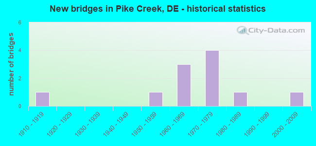
- New bridges - historical statistics
- 11910-1919
- 11950-1959
- 31960-1969
- 41970-1979
- 11980-1989
- 12000-2009
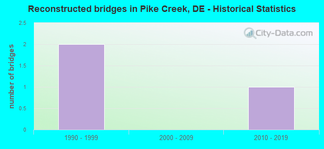
- Reconstructed bridges - Historical Statistics
- 21990-1999
- 02000-2009
- 12010-2019
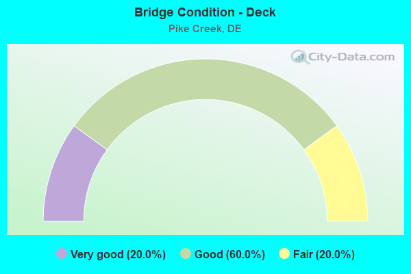
- Bridge Condition - Deck
- 20.0%Very good
- 60.0%Good
- 20.0%Fair
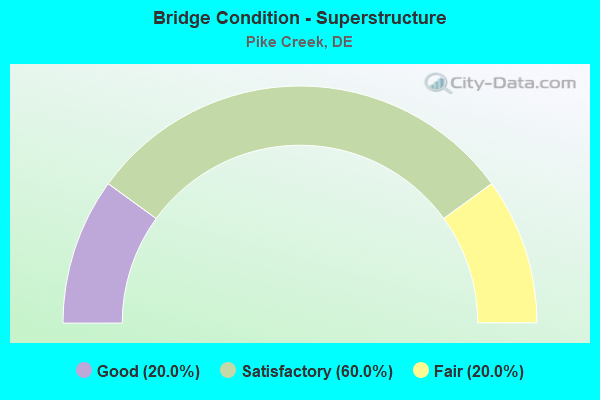
- Bridge Condition - Superstructure
- 20.0%Good
- 60.0%Satisfactory
- 20.0%Fair
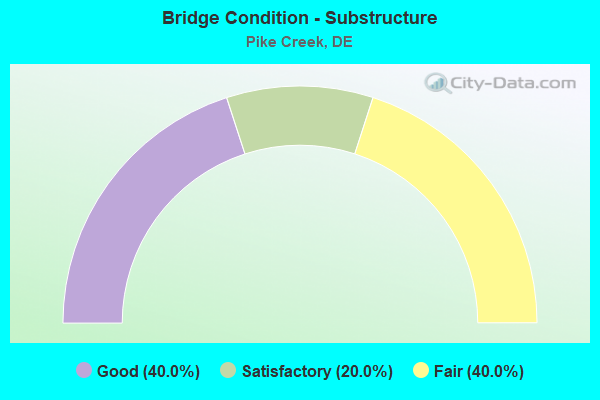
- Bridge Condition - Substructure
- 40.0%Good
- 20.0%Satisfactory
- 40.0%Fair
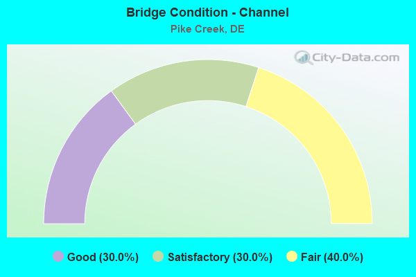
- Bridge Condition - Channel
- 30.0%Good
- 30.0%Satisfactory
- 40.0%Fair
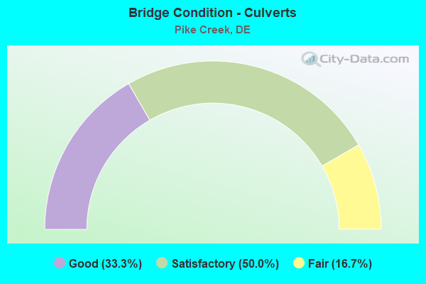
- Bridge Condition - Culverts
- 33.3%Good
- 50.0%Satisfactory
- 16.7%Fair
Find on map >> Show street view
Structure Number: 1187 283, Location: EAST OF MERMAID (Lat: 39.750494, Lng: -75.679336), Route carried "on" structure: County highway 283, Year Built: 1969, Status: Open, Structure Length: 1.43m (4.69ft), Average Daily Traffic: 11,291 (year 2019), Truck Traffic: 8%, Average Future Daily Traffic: 14,033 (year 2042), Design Load: HS 20, Features Intersected: MILL CREEK, Facility Carried by Structure: MERMAID STONEY BAT
Minimum Vertical Clearance: 30.48m (100.00ft), Kilometerpoint: 1.610, Lanes on structure: 2, Owner: State Highway Agency, Approaching Roadway Width: 8.8m (28.9ft), Skew: 2 degrees, Material/Design: Concrete, Design/Construction: Culvert, Number Of Spans In Main Unit: 3, Length of Maximum Span: 4.5m (14.8ft)
Condition: Channel: Fair, Culverts: Satisfactory, Operating Rating: 39.5 metric tons, Method Used To Determine Operating Rating: Load and Resistance Factor Rating (LRFR) rating reported by rating factor(RF) method using HL-93 loadings, Inventory Rating: 30.5 metric tons, Method Used To Determine Inventory Rating: Load and Resistance Factor Rating (LRFR) rating reported by rating factor(RF) method using HL-93 loadings, Structural Evaluation: Equal to present minimum criteria, Waterway Adequacy: Equal to present minimum criteria, Approach Roadway Alignment: Equal to present desirable criteria, Designated Inspection Frequency: Every 24 months, Inspection Date: June 2020
Find on map >> Show street view
Structure Number: 1188, Location: S/ OF DELCASTLE REC. AREA (Lat: 39.736636, Lng: -75.670508), Route carried "on" structure: City street , Year Built: 1971, Status: Open, Structure Length: 0.91m (2.99ft), Average Daily Traffic: 99 (year 2019), Truck Traffic: 8%, Average Future Daily Traffic: 123 (year 2042), Design Load: HS 20, Features Intersected: TRIB OF MILL CREEK, Facility Carried by Structure: ELDERON DRIVE
Minimum Vertical Clearance: 30.48m (100.00ft), Kilometerpoint: 0.016, Lanes on structure: 2, Owner: State Highway Agency, Approaching Roadway Width: 9.7m (31.8ft), Material/Design: Concrete, Design/Construction: Culvert, Number Of Spans In Main Unit: 4, Length of Maximum Span: 2.1m (6.9ft)
Condition: Channel: Fair, Culverts: Good, Operating Rating: 54.4 metric tons, Method Used To Determine Operating Rating: Field evaluation and documented engineering judgment, Inventory Rating: 32.7 metric tons, Method Used To Determine Inventory Rating: Field evaluation and documented engineering judgment, Structural Evaluation: Better than present minimum criteria, Waterway Adequacy: Better than present minimum criteria, Approach Roadway Alignment: Equal to present desirable criteria, Designated Inspection Frequency: Every 24 months, Inspection Date: June 2020
Find on map >> Show street view
Structure Number: 1189, Location: ARUNDEL (Lat: 39.735844, Lng: -75.671603), Route carried "on" structure: City street , Year Built: 1971, Status: Open, Structure Length: 0.91m (2.99ft), Average Daily Traffic: 99 (year 2019), Truck Traffic: 11%, Average Future Daily Traffic: 123 (year 2042), Design Load: HS 20, Features Intersected: TRIB OF MILL CREEK, Facility Carried by Structure: FAWKES DRIVE
Minimum Vertical Clearance: 30.48m (100.00ft), Kilometerpoint: 0.016, Lanes on structure: 2, Owner: State Highway Agency, Maintenance Responsibility: Private, Approaching Roadway Width: 9.9m (32.5ft), Material/Design: Concrete, Design/Construction: Culvert, Number Of Spans In Main Unit: 4, Length of Maximum Span: 2.1m (6.9ft), Curb or Sidewalk Widths: Left: 1.2m (3.9ft), Right: 1.2m (3.9ft), Curb-To-Curb Width: 15.5m (50.9ft), Out-to-Out Width: 16.2m (53.1ft)
Condition: Channel: Good, Culverts: Fair, Operating Rating: 32.7 metric tons, Method Used To Determine Operating Rating: Load and Resistance Factor Rating (LRFR) rating reported by rating factor(RF) method using HL-93 loadings, Inventory Rating: 25.3 metric tons, Method Used To Determine Inventory Rating: Load and Resistance Factor Rating (LRFR) rating reported by rating factor(RF) method using HL-93 loadings, Structural Evaluation: Somewhat better than minimum adequacy, Deck Geometry: Superior to present desirable criteria, Waterway Adequacy: Better than present minimum criteria, Approach Roadway Alignment: Equal to present desirable criteria, Designated Inspection Frequency: Every 24 months, Inspection Date: June 2020, Deck Structure Type: Concrete Cast-file-Place, Wearing Surface/Protective System: Wearing Surface: Bituminous
Find on map >> Show street view
Structure Number: 1190 031, Location: S. OF DELCASTLE REC. AREA (Lat: 39.733697, Lng: -75.673642), Route carried "on" structure: State highway 7, Year Built: 1962, Status: Open, Structure Length: 1.46m (4.79ft), Average Daily Traffic: 38,260 (year 2019), Truck Traffic: 9%, Average Future Daily Traffic: 47,554 (year 2042), Design Load: HS 20, Features Intersected: MILL CREEK
Minimum Vertical Clearance: 30.48m (100.00ft), Kilometerpoint: 3.331, Lanes on structure: 7, Base Highway Network: Yes, Owner: State Highway Agency, Approaching Roadway Width: 27.4m (89.9ft), Skew: 23 degrees, Material/Design: Concrete, Design/Construction: Culvert, Number Of Spans In Main Unit: 3, Length of Maximum Span: 4.7m (15.4ft), Curb or Sidewalk Widths: Left: 1.5m (4.9ft), Right: 1.3m (4.3ft), Curb-To-Curb Width: 26.4m (86.6ft), Out-to-Out Width: 32.2m (105.6ft)
Condition: Channel: Satisfactory, Culverts: Satisfactory, Operating Rating: 92.3 metric tons, Method Used To Determine Operating Rating: Load and Resistance Factor Rating (LRFR) rating reported by rating factor(RF) method using HL-93 loadings, Inventory Rating: 71.9 metric tons, Method Used To Determine Inventory Rating: Load and Resistance Factor Rating (LRFR) rating reported by rating factor(RF) method using HL-93 loadings, Structural Evaluation: Equal to present minimum criteria, Deck Geometry: Meets minimum limits, Waterway Adequacy: Equal to present minimum criteria, Approach Roadway Alignment: Equal to present desirable criteria, Designated Inspection Frequency: Every 24 months, Inspection Date: July 2020, Deck Structure Type: Concrete Cast-file-Place, Wearing Surface/Protective System: Wearing Surface: Bituminous
Find on map >> Show street view
Structure Number: 1191 318, Location: MILLTOWN (Lat: 39.729742, Lng: -75.668508), Route carried "on" structure: County highway 318, Year Built: 1959, Year Reconstructed: 2016, Status: Open, Structure Length: 2.90m (9.51ft), Average Daily Traffic: 8,080 (year 2019), Truck Traffic: 9%, Average Future Daily Traffic: 10,042 (year 2042), Design Load: HS 20, Features Intersected: MILL CREEK, Facility Carried by Structure: MILLTOWN RD
Minimum Vertical Clearance: 30.48m (100.00ft), Kilometerpoint: 1.720, Lanes on structure: 2, Owner: State Highway Agency, Approaching Roadway Width: 12.9m (42.3ft), Skew: 2 degrees, Material/Design: Steel, Design/Construction: Stringer/Multi-beam, Number Of Spans In Main Unit: 1, Length of Maximum Span: 28.0m (91.9ft), Curb or Sidewalk Widths: Left: 1.6m (5.2ft), Right: 1.6m (5.2ft), Curb-To-Curb Width: 12.2m (40.0ft), Out-to-Out Width: 16.5m (54.1ft)
Condition: Deck: Very good, Superstructure: Good, Substructure: Good, Channel: Satisfactory, Operating Rating: 59.9 metric tons, Method Used To Determine Operating Rating: Load and Resistance Factor Rating (LRFR) rating reported by rating factor(RF) method using HL-93 loadings, Inventory Rating: 46.3 metric tons, Method Used To Determine Inventory Rating: Load and Resistance Factor Rating (LRFR) rating reported by rating factor(RF) method using HL-93 loadings, Structural Evaluation: Better than present minimum criteria, Deck Geometry: Somewhat better than minimum adequacy, Waterway Adequacy: Equal to present minimum criteria, Approach Roadway Alignment: Equal to present desirable criteria, Designated Inspection Frequency: Every 24 months, Inspection Date: July 2020, Deck Structure Type: Concrete Cast-file-Place, Wearing Surface/Protective System: Wearing Surface: Monolithic Concrete, Deck Protection: Epoxy Coated Reinforcing
Find on map >> Show street view
Structure Number: 1192 318C, Location: MILLTOWN (Lat: 39.729628, Lng: -75.667717), Route carried "on" structure: County highway 318C, Year Built: 1913, Year Reconstructed: 1999, Status: Open, Structure Length: 1.19m (3.90ft), Average Daily Traffic: 11,615 (year 2019), Truck Traffic: 11%, Average Future Daily Traffic: 14,573 (year 2043), Design Load: HS 25 or greater, Features Intersected: MILL CREEK, Facility Carried by Structure: OLD MILLTOWN RD.
Minimum Vertical Clearance: 30.48m (100.00ft), Kilometerpoint: 0.209, Lanes on structure: 1, Owner: State Highway Agency, Approaching Roadway Width: 4.3m (14.1ft), Skew: 3 degrees, Material/Design: Steel, Design/Construction: Stringer/Multi-beam, Number Of Spans In Main Unit: 1, Length of Maximum Span: 10.7m (35.1ft), Curb-To-Curb Width: 4.0m (13.1ft), Out-to-Out Width: 5.0m (16.4ft)
Condition: Deck: Good, Superstructure: Satisfactory, Substructure: Fair, Channel: Satisfactory, Operating Rating: 66.1 metric tons, Method Used To Determine Operating Rating: Load and Resistance Factor Rating (LRFR) rating reported by rating factor(RF) method using HL-93 loadings, Inventory Rating: 49.9 metric tons, Method Used To Determine Inventory Rating: Load and Resistance Factor Rating (LRFR) rating reported by rating factor(RF) method using HL-93 loadings, Structural Evaluation: Somewhat better than minimum adequacy, Deck Geometry: High priority of replacement, Waterway Adequacy: Better than present minimum criteria, Approach Roadway Alignment: Equal to present desirable criteria, Length Of Structure Improvement: 3.05m (10.01ft), Designated Inspection Frequency: Every 24 months, Inspection Date: March 2021, Bridge Improvement Cost: $500,000, Roadway Improvement Cost: $100,000, Total Project Cost: $600,000, Deck Structure Type: Other, Wearing Surface/Protective System: Wearing Surface: Epoxy Overlay
Find on map >> Show street view
Structure Number: 1196 316, Location: N/W OF DELAWARE PARK (Lat: 39.713514, Lng: -75.695239), Route carried "on" structure: County highway 316, Year Built: 1988, Status: Open, Structure Length: 1.26m (4.13ft), Average Daily Traffic: 5,605 (year 2019), Truck Traffic: 8%, Average Future Daily Traffic: 6,966 (year 2042), Design Load: HS 20, Features Intersected: PIKE CREEK, Facility Carried by Structure: PIKE CREEK RD.
Minimum Vertical Clearance: 30.48m (100.00ft), Kilometerpoint: 1.460, Lanes on structure: 2, Owner: State Highway Agency, Approaching Roadway Width: 11.6m (38.1ft), Skew: 1 degrees, Material/Design: Prestressed concrete, Design/Construction: Box Beam or Girders - Multiple, Number Of Spans In Main Unit: 1, Length of Maximum Span: 12.2m (40.0ft), Curb-To-Curb Width: 13.4m (44.0ft), Out-to-Out Width: 14.2m (46.6ft)
Condition: Deck: Good, Superstructure: Satisfactory, Substructure: Satisfactory, Channel: Fair, Operating Rating: 53.1 metric tons, Method Used To Determine Operating Rating: Load and Resistance Factor Rating (LRFR) rating reported by rating factor(RF) method using HL-93 loadings, Inventory Rating: 41.5 metric tons, Method Used To Determine Inventory Rating: Load and Resistance Factor Rating (LRFR) rating reported by rating factor(RF) method using HL-93 loadings, Structural Evaluation: Equal to present minimum criteria, Deck Geometry: Equal to present minimum criteria, Waterway Adequacy: Equal to present minimum criteria, Approach Roadway Alignment: Equal to present desirable criteria, Designated Inspection Frequency: Every 24 months, Inspection Date: July 2020, Deck Structure Type: Concrete Cast-file-Place, Wearing Surface/Protective System: Wearing Surface: Monolithic Concrete, Deck Protection: Epoxy Coated Reinforcing
Find on map >> Show street view
Structure Number: 1200 321, Location: WEST OF MILLTOWN (Lat: 39.721936, Lng: -75.698667), Route carried "on" structure: County highway 321, Year Built: 1970, Status: Open, Structure Length: 0.98m (3.22ft), Average Daily Traffic: 15,850 (year 2019), Truck Traffic: 9%, Average Future Daily Traffic: 19,700 (year 2042), Design Load: HS 20, Features Intersected: PIKE CREEK, Facility Carried by Structure: NEW LINDEN HILL RD
Minimum Vertical Clearance: 30.48m (100.00ft), Kilometerpoint: 1.460, Lanes on structure: 2, Owner: State Highway Agency, Approaching Roadway Width: 14.8m (48.6ft), Material/Design: Concrete, Design/Construction: Culvert, Number Of Spans In Main Unit: 3, Length of Maximum Span: 3.0m (9.8ft), Curb or Sidewalk Widths: Left: 1.8m (5.9ft), Right: 0.0m
Condition: Channel: Fair, Culverts: Satisfactory, Operating Rating: 97.2 metric tons, Method Used To Determine Operating Rating: Load and Resistance Factor Rating (LRFR) rating reported by rating factor(RF) method using HL-93 loadings, Inventory Rating: 97.2 metric tons, Method Used To Determine Inventory Rating: Load and Resistance Factor Rating (LRFR) rating reported by rating factor(RF) method using HL-93 loadings, Structural Evaluation: Equal to present minimum criteria, Waterway Adequacy: Equal to present minimum criteria, Approach Roadway Alignment: Equal to present desirable criteria, Designated Inspection Frequency: Every 24 months, Inspection Date: July 2020
Find on map >> Show street view
Structure Number: 1202 298, Location: WEST OF MERMAID (Lat: 39.740500, Lng: -75.711686), Route carried "on" structure: County highway 298, Year Built: 1970, Status: Open, Structure Length: 0.98m (3.22ft), Average Daily Traffic: 800 (year 2019), Truck Traffic: 11%, Average Future Daily Traffic: 994 (year 2042), Design Load: HS 20, Features Intersected: PIKE CREEK, Facility Carried by Structure: GRANVILLE RD
Minimum Vertical Clearance: 30.48m (100.00ft), Kilometerpoint: 0.020, Lanes on structure: 2, Owner: State Highway Agency, Approaching Roadway Width: 3.4m (11.2ft), Material/Design: Concrete, Design/Construction: Culvert, Number Of Spans In Main Unit: 2, Length of Maximum Span: 4.7m (15.4ft), Curb-To-Curb Width: 10.9m (35.8ft), Out-to-Out Width: 11.5m (37.7ft)
Condition: Channel: Good, Culverts: Good, Operating Rating: 31.4 metric tons, Method Used To Determine Operating Rating: Load and Resistance Factor Rating (LRFR) rating reported by rating factor(RF) method using HL-93 loadings, Inventory Rating: 24.3 metric tons, Method Used To Determine Inventory Rating: Load and Resistance Factor Rating (LRFR) rating reported by rating factor(RF) method using HL-93 loadings, Structural Evaluation: Equal to present minimum criteria, Deck Geometry: Equal to present minimum criteria, Waterway Adequacy: Better than present minimum criteria, Approach Roadway Alignment: Equal to present desirable criteria, Designated Inspection Frequency: Every 24 months, Inspection Date: June 2020, Deck Structure Type: Concrete Cast-file-Place, Wearing Surface/Protective System: Wearing Surface: Bituminous
Find on map >> Show street view
Structure Number: 1233 012, Location: KIAMENSI (Lat: 39.726144, Lng: -75.651844), Route carried "on" structure: County highway 12, Year Built: 2003, Status: Open, Structure Length: 0.76m (2.49ft), Average Daily Traffic: 8,818 (year 2019), Truck Traffic: 8%, Average Future Daily Traffic: 10,960 (year 2042), Design Load: HS 20+Mod, Features Intersected: CALF RUN, Facility Carried by Structure: OLD CAPITOL TRAIL
Minimum Vertical Clearance: 30.48m (100.00ft), Kilometerpoint: 0.260, Lanes on structure: 2, Owner: State Highway Agency, Approaching Roadway Width: 7.9m (25.9ft), Material/Design: Prestressed concrete, Design/Construction: Box Beam or Girders - Multiple, Number Of Spans In Main Unit: 1, Length of Maximum Span: 6.7m (22.0ft), Curb or Sidewalk Widths: Left: 0.0m, Right: 1.5m (4.9ft), Curb-To-Curb Width: 12.1m (39.7ft), Out-to-Out Width: 14.5m (47.6ft)
Condition: Deck: Good, Superstructure: Satisfactory, Substructure: Good, Channel: Good, Operating Rating: 38.9 metric tons, Method Used To Determine Operating Rating: Load and Resistance Factor Rating (LRFR) rating reported by rating factor(RF) method using HL-93 loadings, Inventory Rating: 30.8 metric tons, Method Used To Determine Inventory Rating: Load and Resistance Factor Rating (LRFR) rating reported by rating factor(RF) method using HL-93 loadings, Structural Evaluation: Equal to present minimum criteria, Deck Geometry: Somewhat better than minimum adequacy, Waterway Adequacy: Better than present minimum criteria, Approach Roadway Alignment: Equal to present desirable criteria, Designated Inspection Frequency: Every 24 months, Inspection Date: June 2020, Deck Structure Type: Concrete Cast-file-Place, Wearing Surface/Protective System: Wearing Surface: Monolithic Concrete, Deck Protection: Epoxy Coated Reinforcing
Find on map >> Show street view
Structure Number: 1655 031, Location: N/W OF STANTON (Lat: 39.718292, Lng: -75.652906), Route carried "on" structure: State highway 7, Year Built: 1960, Year Reconstructed: 1995, Status: Open, Structure Length: 4.33m (14.21ft), Average Daily Traffic: 47,767 (year 2019), Truck Traffic: 8%, Average Future Daily Traffic: 59,370 (year 2042), Design Load: HS 20, Features Intersected: CSX RAILROAD
Minimum Vertical Clearance: 30.48m (100.00ft), Kilometerpoint: 0.820, Lanes on structure: 4, Base Highway Network: Yes, Owner: State Highway Agency, Approaching Roadway Width: 20.1m (65.9ft), Skew: 31 degrees, Material/Design: Steel, Design/Construction: Stringer/Multi-beam, Number Of Spans In Main Unit: 3, Length of Maximum Span: 16.2m (53.1ft), Curb or Sidewalk Widths: Left: 1.2m (3.9ft), Right: 1.2m (3.9ft), Curb-To-Curb Width: 20.1m (65.9ft), Out-to-Out Width: 30.0m (98.4ft)
Condition: Deck: Fair, Superstructure: Fair, Substructure: Fair, Operating Rating: 71.3 metric tons, Method Used To Determine Operating Rating: Load and Resistance Factor Rating (LRFR) rating reported by rating factor(RF) method using HL-93 loadings, Inventory Rating: 54.8 metric tons, Method Used To Determine Inventory Rating: Load and Resistance Factor Rating (LRFR) rating reported by rating factor(RF) method using HL-93 loadings, Structural Evaluation: Somewhat better than minimum adequacy, Deck Geometry: Better than present minimum criteria, Underclear: Better than present minimum criteria, Approach Roadway Alignment: Equal to present desirable criteria, Designated Inspection Frequency: Every 24 months, Inspection Date: Febuary 2020, Bridge Improvement Cost: $800,000, Roadway Improvement Cost: $200,000, Total Project Cost: $1,000,000, Deck Structure Type: Concrete Cast-file-Place, Wearing Surface/Protective System: Wearing Surface: Monolithic Concrete