Bridge Statistics for Pigeon, Michigan (MI)
Condition, Traffic, Stress, Structural Evaluation, Project Costs
- National Bridge Inventory (NBI) Statistics
- 12Number of bridges
- 115ft / 34.8mTotal length
- $1,883,000Total costs
- 11,574Total average daily traffic
- 404Total average daily truck traffic
- 17,473Total future (year 2029) average daily traffic
- National Bridge Inventory (NBI) Registered Bridges for Pigeon
- No street view available for this location
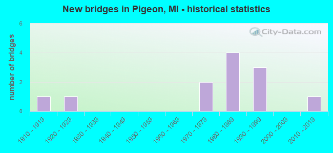
- New bridges - historical statistics
- 11910-1919
- 11920-1929
- 21970-1979
- 41980-1989
- 31990-1999
- 12010-2019


- Bridge Condition - Deck
- 8.3%Very good
- 83.3%Good
- 8.3%Satisfactory

- Bridge Condition - Superstructure
- 8.3%Very good
- 25.0%Good
- 8.3%Satisfactory
- 33.3%Fair
- 16.7%Poor
- 8.3%Serious

- Bridge Condition - Substructure
- 8.3%Very good
- 41.7%Good
- 33.3%Satisfactory
- 16.7%Fair

- Bridge Condition - Channel
- 8.3%Very good
- 25.0%Good
- 41.7%Satisfactory
- 25.0%Fair
Find on map >> Show street view
Structure Number: 3454, Location: 1.0 MI W OF PIGEON (Lat: 43.829586, Lng: -83.288050), Route carried "on" structure: State highway 142, Year Built: 2011, Status: Open, Structure Length: 5.03m (16.50ft), Average Daily Traffic: 4,500 (year 2011), Truck Traffic: 1%, Average Future Daily Traffic: 4,700 (year 2031), Design Load: HL 93, Features Intersected: PIGEON RIVER
Minimum Vertical Clearance: 30.48m (100.00ft), Kilometerpoint: 7.258, Lanes on structure: 2, Base Highway Network: Yes (Inventory Route: 332, Subroute: 33), Owner: State Highway Agency, Approaching Roadway Width: 12.8m (42.0ft), Material/Design: Prestressed concrete, Design/Construction: Box Beam or Girders - Single/Spread, Number Of Spans In Main Unit: 3, Length of Maximum Span: 19.3m (63.3ft), Curb-To-Curb Width: 13.4m (44.0ft), Out-to-Out Width: 14.1m (46.3ft)
Condition: Deck: Good, Superstructure: Very good, Substructure: Very good, Channel: Very good, Operating Rating: 56.1 metric tons, Method Used To Determine Operating Rating: Load and Resistance Factor Rating (LRFR) rating reported by rating factor(RF) method using HL-93 loadings, Inventory Rating: 35.0 metric tons, Method Used To Determine Inventory Rating: Load and Resistance Factor Rating (LRFR) rating reported by rating factor(RF) method using HL-93 loadings, Structural Evaluation: Equal to present desirable criteria, Deck Geometry: Better than present minimum criteria, Waterway Adequacy: Somewhat better than minimum adequacy, Approach Roadway Alignment: Equal to present minimum criteria, Designated Inspection Frequency: Every 24 months, Inspection Date: October 2020, Deck Structure Type: Concrete Cast-file-Place, Wearing Surface/Protective System: Wearing Surface: Monolithic Concrete, Deck Protection: Epoxy Coated Reinforcing
Find on map >> Show street view
Structure Number: 3539, Location: SEC. 14-15 WINSOR TWP. (Lat: 43.814133, Lng: -83.279108), Route carried "on" structure: County highway 3223, Year Built: 1995, Status: Open, Structure Length: 3.21m (10.53ft), Average Daily Traffic: 2,035 (year 2009), Truck Traffic: 3%, Average Future Daily Traffic: 3,675 (year 2029), Design Load: HS 20, Features Intersected: PIGEON RIVER, Facility Carried by Structure: CASEVILLE ROAD
Minimum Vertical Clearance: 30.48m (100.00ft), Kilometerpoint: 9.470, Lanes on structure: 2, Owner: County Highway Agency, Approaching Roadway Width: 11.6m (38.1ft), Skew: 3 degrees, Material/Design: Prestressed concrete, Design/Construction: Tee Beam, Number Of Spans In Main Unit: 3, Length of Maximum Span: 10.7m (35.1ft), Curb-To-Curb Width: 11.4m (37.4ft), Out-to-Out Width: 12.3m (40.4ft)
Condition: Deck: Good, Superstructure: Poor, Substructure: Good, Channel: Satisfactory, Operating Rating: 41.1 metric tons, Method Used To Determine Operating Rating: Load and Resistance Factor Rating (LRFR) rating reported by rating factor(RF) method using HL-93 loadings, Inventory Rating: 31.8 metric tons, Method Used To Determine Inventory Rating: Load and Resistance Factor Rating (LRFR) rating reported by rating factor(RF) method using HL-93 loadings, Structural Evaluation: Meets minimum limits, Deck Geometry: Somewhat better than minimum adequacy, Waterway Adequacy: Equal to present desirable criteria, Approach Roadway Alignment: Equal to present minimum criteria, Designated Inspection Frequency: Every 12 months, Inspection Date: September 2021, Deck Structure Type: Concrete Precast Panels, Wearing Surface/Protective System: Wearing Surface: Bituminous, Membrane: Built-up
Find on map >> Show street view
Structure Number: 354, Location: SEC. 26-27 MCKINLEY TWP. (Lat: 43.865453, Lng: -83.280428), Route carried "on" structure: County highway 3223, Year Built: 1923, Year Reconstructed: 1969, Status: Posted for load, Structure Length: 3.20m (10.50ft), Average Daily Traffic: 2,654 (year 2014), Truck Traffic: 10%, Average Future Daily Traffic: 4,793 (year 2034), Design Load: H 20, Features Intersected: PIGEON RIVER, Facility Carried by Structure: CASEVILLE ROAD
Minimum Vertical Clearance: 30.48m (100.00ft), Kilometerpoint: 15.198, Lanes on structure: 2, Owner: County Highway Agency, Approaching Roadway Width: 9.8m (32.2ft), Material/Design: Prestressed concrete, Design/Construction: Box Beam or Girders - Multiple, Number Of Spans In Main Unit: 2, Length of Maximum Span: 15.6m (51.2ft), Curb-To-Curb Width: 8.1m (26.6ft), Out-to-Out Width: 8.3m (27.2ft)
Condition: Deck: Satisfactory, Superstructure: Serious, Substructure: Satisfactory, Channel: Satisfactory, Operating Rating: 71.3 metric tons, Method Used To Determine Operating Rating: Load Factor (LF) rating reported by rating factor (RF) method using MS18 loading, Inventory Rating: 49.6 metric tons, Method Used To Determine Inventory Rating: Load Factor (LF) rating reported by rating factor (RF) method using MS18 loading, Structural Evaluation: High priority of corrective action, Deck Geometry: High priority of corrective action, Waterway Adequacy: Equal to present desirable criteria, Approach Roadway Alignment: Equal to present minimum criteria, Bridge Posting: Required (Relationship of Operating Rating to Maximum Legal Load: 0.1 - 9.9% below), Length Of Structure Improvement: 3.96m (12.99ft), Designated Inspection Frequency: Every 12 months, Inspection Date: September 2021, Bridge Improvement Cost: $1,580,000, Roadway Improvement Cost: $301,000, Total Project Cost: $1,883,000, Deck Structure Type: Concrete Precast Panels, Wearing Surface/Protective System: Wearing Surface: Bituminous
Find on map >> Show street view
Structure Number: 3621, Location: SEC. 34 MCKINLEY TWP. (Lat: 43.844197, Lng: -83.284339), Route carried "on" structure: ServiceCounty highway , Year Built: 1910, Year Reconstructed: 1971, Status: Open, Structure Length: 2.40m (7.87ft), Average Daily Traffic: 465 (year 2009), Truck Traffic: 1%, Average Future Daily Traffic: 840 (year 2029), Design Load: HS 20, Features Intersected: PIGEON RIVER, Facility Carried by Structure: BERNE ROAD
Minimum Vertical Clearance: 30.48m (100.00ft), Kilometerpoint: 3.967, Lanes on structure: 2, Owner: County Highway Agency, Approaching Roadway Width: 9.1m (29.9ft), Material/Design: Prestressed concrete, Design/Construction: Tee Beam, Number Of Spans In Main Unit: 1, Length of Maximum Span: 23.1m (75.8ft), Curb-To-Curb Width: 6.8m (22.3ft), Out-to-Out Width: 6.9m (22.6ft)
Condition: Deck: Good, Superstructure: Poor, Substructure: Satisfactory, Channel: Good, Operating Rating: 33.4 metric tons, Method Used To Determine Operating Rating: Load and Resistance Factor Rating (LRFR) rating reported by rating factor(RF) method using HL-93 loadings, Inventory Rating: 17.2 metric tons, Method Used To Determine Inventory Rating: Load and Resistance Factor Rating (LRFR) rating reported by rating factor(RF) method using HL-93 loadings, Structural Evaluation: Meets minimum limits, Deck Geometry: Meets minimum limits, Waterway Adequacy: Equal to present desirable criteria, Approach Roadway Alignment: Equal to present minimum criteria, Designated Inspection Frequency: Every 12 months, Inspection Date: September 2021, Deck Structure Type: Concrete Precast Panels, Wearing Surface/Protective System: Wearing Surface: Bituminous
Find on map >> Show street view
Structure Number: 3622, Location: SEC. 27-34 MCKINLEY TWP (Lat: 43.858622, Lng: -83.282622), Route carried "on" structure: ServiceCounty highway , Year Built: 1987, Status: Open, Structure Length: 2.93m (9.61ft), Average Daily Traffic: 80 (year 2009), Average Future Daily Traffic: 145 (year 2029), Design Load: HS 20, Features Intersected: PIGEON RIVER, Facility Carried by Structure: CAMPBELL ROAD
Minimum Vertical Clearance: 30.48m (100.00ft), Kilometerpoint: 3.409, Lanes on structure: 2, Owner: County Highway Agency, Approaching Roadway Width: 9.1m (29.9ft), Material/Design: Prestressed concrete, Design/Construction: Tee Beam, Number Of Spans In Main Unit: 4, Length of Maximum Span: 6.6m (21.7ft), Curb-To-Curb Width: 9.0m (29.5ft), Out-to-Out Width: 9.8m (32.2ft)
Condition: Deck: Good, Superstructure: Fair, Substructure: Good, Channel: Satisfactory, Operating Rating: 44.1 metric tons, Method Used To Determine Operating Rating: Load and Resistance Factor Rating (LRFR) rating reported by rating factor(RF) method using HL-93 loadings, Inventory Rating: 34.0 metric tons, Method Used To Determine Inventory Rating: Load and Resistance Factor Rating (LRFR) rating reported by rating factor(RF) method using HL-93 loadings, Structural Evaluation: Somewhat better than minimum adequacy, Deck Geometry: Better than present minimum criteria, Waterway Adequacy: Equal to present desirable criteria, Approach Roadway Alignment: Equal to present desirable criteria, Designated Inspection Frequency: Every 24 months, Inspection Date: September 2021, Deck Structure Type: Concrete Precast Panels, Wearing Surface/Protective System: Wearing Surface: Bituminous, Membrane: Preformed Fabric
Find on map >> Show street view
Structure Number: 3623, Location: SEC 23-26 MCKINLEY TWP (Lat: 43.873225, Lng: -83.277575), Route carried "on" structure: ServiceCounty highway , Year Built: 1987, Status: Open, Structure Length: 3.58m (11.75ft), Average Daily Traffic: 125 (year 2009), Truck Traffic: 3%, Average Future Daily Traffic: 225 (year 2029), Design Load: HS 20, Features Intersected: PIGEON RIVER, Facility Carried by Structure: CROWN ROAD
Minimum Vertical Clearance: 30.48m (100.00ft), Kilometerpoint: 3.549, Lanes on structure: 2, Owner: County Highway Agency, Approaching Roadway Width: 9.1m (29.9ft), Skew: 3 degrees, Material/Design: Prestressed concrete, Design/Construction: Tee Beam, Number Of Spans In Main Unit: 4, Length of Maximum Span: 8.5m (27.9ft), Curb-To-Curb Width: 9.0m (29.5ft), Out-to-Out Width: 9.8m (32.2ft)
Condition: Deck: Good, Superstructure: Fair, Substructure: Good, Channel: Fair, Operating Rating: 41.5 metric tons, Method Used To Determine Operating Rating: Load and Resistance Factor Rating (LRFR) rating reported by rating factor(RF) method using HL-93 loadings, Inventory Rating: 32.1 metric tons, Method Used To Determine Inventory Rating: Load and Resistance Factor Rating (LRFR) rating reported by rating factor(RF) method using HL-93 loadings, Structural Evaluation: Somewhat better than minimum adequacy, Deck Geometry: Equal to present minimum criteria, Waterway Adequacy: Equal to present desirable criteria, Approach Roadway Alignment: Equal to present desirable criteria, Designated Inspection Frequency: Every 24 months, Inspection Date: September 2021, Deck Structure Type: Concrete Precast Panels, Wearing Surface/Protective System: Wearing Surface: Bituminous
Find on map >> Show street view
Structure Number: 3675, Location: SEC. 24-25 WINSOR TWP (Lat: 43.787331, Lng: -83.244483), Route carried "on" structure: ServiceCounty highway , Year Built: 1987, Status: Open, Structure Length: 2.92m (9.58ft), Average Daily Traffic: 150 (year 2009), Truck Traffic: 1%, Average Future Daily Traffic: 270 (year 2029), Design Load: HS 20, Features Intersected: PIGEON RIVER, Facility Carried by Structure: HAIST ROAD
Minimum Vertical Clearance: 30.48m (100.00ft), Kilometerpoint: 15.082, Lanes on structure: 2, Owner: County Highway Agency, Approaching Roadway Width: 9.1m (29.9ft), Material/Design: Prestressed concrete, Design/Construction: Tee Beam, Number Of Spans In Main Unit: 4, Length of Maximum Span: 7.0m (23.0ft), Curb-To-Curb Width: 8.9m (29.2ft), Out-to-Out Width: 9.8m (32.2ft)
Condition: Deck: Very good, Superstructure: Fair, Substructure: Fair, Channel: Fair, Operating Rating: 95.7 metric tons, Method Used To Determine Operating Rating: Load Factor (LF), Inventory Rating: 57.3 metric tons, Method Used To Determine Inventory Rating: Load Factor (LF), Structural Evaluation: Somewhat better than minimum adequacy, Deck Geometry: Equal to present minimum criteria, Waterway Adequacy: Equal to present desirable criteria, Approach Roadway Alignment: Superior to present desirable criteria, Designated Inspection Frequency: Every 24 months, Inspection Date: September 2021, Deck Structure Type: Concrete Precast Panels, Wearing Surface/Protective System: Wearing Surface: Bituminous, Membrane: Preformed Fabric, Deck Protection: Epoxy Coated Reinforcing
Find on map >> Show street view
Structure Number: 3676, Location: SEC. 24 WINSOR TWP. (Lat: 43.794361, Lng: -83.254447), Route carried "on" structure: ServiceCounty highway , Year Built: 1993, Status: Open, Structure Length: 2.93m (9.61ft), Average Daily Traffic: 25 (year 2009), Average Future Daily Traffic: 45 (year 2029), Design Load: HS 20, Features Intersected: PIGEON RIVER, Facility Carried by Structure: BRODERICK ROAD
Minimum Vertical Clearance: 30.48m (100.00ft), Kilometerpoint: 1.962, Lanes on structure: 2, Owner: County Highway Agency, Approaching Roadway Width: 9.1m (29.9ft), Material/Design: Prestressed concrete, Design/Construction: Box Beam or Girders - Multiple, Number Of Spans In Main Unit: 2, Length of Maximum Span: 14.6m (47.9ft), Curb-To-Curb Width: 9.6m (31.5ft), Out-to-Out Width: 10.5m (34.4ft)
Condition: Deck: Good, Superstructure: Fair, Substructure: Good, Channel: Fair, Operating Rating: 43.4 metric tons, Method Used To Determine Operating Rating: Load and Resistance Factor Rating (LRFR) rating reported by rating factor(RF) method using HL-93 loadings, Inventory Rating: 33.4 metric tons, Method Used To Determine Inventory Rating: Load and Resistance Factor Rating (LRFR) rating reported by rating factor(RF) method using HL-93 loadings, Structural Evaluation: Somewhat better than minimum adequacy, Deck Geometry: Better than present minimum criteria, Waterway Adequacy: Equal to present desirable criteria, Approach Roadway Alignment: Better than present minimum criteria, Designated Inspection Frequency: Every 24 months, Inspection Date: September 2021, Deck Structure Type: Concrete Precast Panels, Wearing Surface/Protective System: Wearing Surface: Bituminous, Membrane: Built-up
Find on map >> Show street view
Structure Number: 3677, Location: SEC. 14-23 WINSOR TWP. (Lat: 43.801356, Lng: -83.261856), Route carried "on" structure: ServiceCounty highway , Year Built: 1982, Status: Open, Structure Length: 3.04m (9.97ft), Average Daily Traffic: 250 (year 2009), Truck Traffic: 2%, Average Future Daily Traffic: 450 (year 2029), Design Load: HS 20, Features Intersected: PIGEON RIVER, Facility Carried by Structure: GEIGER ROAD
Minimum Vertical Clearance: 30.48m (100.00ft), Kilometerpoint: 13.416, Lanes on structure: 2, Owner: County Highway Agency, Approaching Roadway Width: 10.4m (34.1ft), Skew: 4 degrees, Material/Design: Prestressed concrete, Design/Construction: Tee Beam, Number Of Spans In Main Unit: 2, Length of Maximum Span: 14.4m (47.2ft), Curb-To-Curb Width: 9.1m (29.9ft), Out-to-Out Width: 10.0m (32.8ft)
Condition: Deck: Good, Superstructure: Satisfactory, Substructure: Good, Channel: Good, Operating Rating: 79.3 metric tons, Method Used To Determine Operating Rating: Load Factor (LF), Inventory Rating: 47.5 metric tons, Method Used To Determine Inventory Rating: Load Factor (LF), Structural Evaluation: Equal to present minimum criteria, Deck Geometry: Equal to present minimum criteria, Waterway Adequacy: Equal to present desirable criteria, Approach Roadway Alignment: Superior to present desirable criteria, Designated Inspection Frequency: Every 24 months, Inspection Date: September 2021, Deck Structure Type: Concrete Precast Panels, Wearing Surface/Protective System: Wearing Surface: Bituminous, Membrane: Preformed Fabric
Find on map >> Show street view
Structure Number: 3678, Location: SEC. 10-15 WINSOR TWP. (Lat: 43.815283, Lng: -83.284811), Route carried "on" structure: ServiceCounty highway , Year Built: 1970, Status: Posted for load, Structure Length: 1.71m (5.61ft), Average Daily Traffic: 890 (year 2009), Truck Traffic: 2%, Average Future Daily Traffic: 1,610 (year 2029), Design Load: H 20, Features Intersected: PIGEON RIVER, Facility Carried by Structure: WEALE ROAD
Minimum Vertical Clearance: 30.48m (100.00ft), Kilometerpoint: 9.093, Lanes on structure: 2, Owner: County Highway Agency, Approaching Roadway Width: 9.1m (29.9ft), Material/Design: Steel, Design/Construction: Stringer/Multi-beam, Number Of Spans In Main Unit: 1, Length of Maximum Span: 15.8m (51.8ft), Curb-To-Curb Width: 7.3m (24.0ft), Out-to-Out Width: 7.3m (24.0ft)
Condition: Deck: Good, Superstructure: Good, Substructure: Satisfactory, Channel: Satisfactory, Operating Rating: 48.6 metric tons, Method Used To Determine Operating Rating: Load Factor (LF) rating reported by rating factor (RF) method using MS18 loading, Inventory Rating: 29.2 metric tons, Method Used To Determine Inventory Rating: Load Factor (LF) rating reported by rating factor (RF) method using MS18 loading, Structural Evaluation: Equal to present minimum criteria, Deck Geometry: Meets minimum limits, Waterway Adequacy: Equal to present desirable criteria, Approach Roadway Alignment: Equal to present minimum criteria, Bridge Posting: Required (Relationship of Operating Rating to Maximum Legal Load: 10.0 - 19.9% below), Designated Inspection Frequency: Every 24 months, Inspection Date: August 2021, Deck Structure Type: Concrete Cast-file-Place, Wearing Surface/Protective System: Wearing Surface: Monolithic Concrete
Find on map >> Show street view
Structure Number: 368, Location: SEC. 23-24 WINSOR TWP (Lat: 43.800000, Lng: -83.258772), Route carried "on" structure: ServiceCounty highway , Year Built: 1990, Status: Open, Structure Length: 2.92m (9.58ft), Average Daily Traffic: 250 (year 2009), Truck Traffic: 1%, Average Future Daily Traffic: 450 (year 2029), Design Load: HS 20, Features Intersected: PIGEON RIVER, Facility Carried by Structure: NOTTER ROAD
Minimum Vertical Clearance: 30.48m (100.00ft), Kilometerpoint: 14.280, Lanes on structure: 2, Owner: County Highway Agency, Approaching Roadway Width: 9.1m (29.9ft), Material/Design: Prestressed concrete, Design/Construction: Tee Beam, Number Of Spans In Main Unit: 4, Length of Maximum Span: 7.2m (23.6ft), Curb-To-Curb Width: 8.9m (29.2ft), Out-to-Out Width: 9.8m (32.2ft)
Condition: Deck: Good, Superstructure: Good, Substructure: Fair, Channel: Good, Operating Rating: 47.0 metric tons, Method Used To Determine Operating Rating: Load and Resistance Factor Rating (LRFR) rating reported by rating factor(RF) method using HL-93 loadings, Inventory Rating: 36.3 metric tons, Method Used To Determine Inventory Rating: Load and Resistance Factor Rating (LRFR) rating reported by rating factor(RF) method using HL-93 loadings, Structural Evaluation: Somewhat better than minimum adequacy, Deck Geometry: Equal to present minimum criteria, Waterway Adequacy: Equal to present desirable criteria, Approach Roadway Alignment: Equal to present desirable criteria, Designated Inspection Frequency: Every 24 months, Inspection Date: September 2021, Deck Structure Type: Concrete Precast Panels, Wearing Surface/Protective System: Wearing Surface: Bituminous, Membrane: Preformed Fabric
Find on map >> Show street view
Structure Number: 12647, Location: SEC 27-28 WINSOR TWP (Lat: 43.791417, Lng: -83.298253), Route carried "on" structure: Alternate County highway , Year Built: 1979, Status: Open, Structure Length: 0.88m (2.89ft), Average Daily Traffic: 150 (year 2009), Truck Traffic: 1%, Average Future Daily Traffic: 270 (year 2029), Design Load: H 20, Features Intersected: WEST BRANCH DRAIN, Facility Carried by Structure: BROWN ROAD
Minimum Vertical Clearance: 30.48m (100.00ft), Kilometerpoint: 3.779, Lanes on structure: 2, Owner: County Highway Agency, Approaching Roadway Width: 9.1m (29.9ft), Material/Design: Steel, Design/Construction: Stringer/Multi-beam, Number Of Spans In Main Unit: 1, Length of Maximum Span: 6.1m (20.0ft), Curb-To-Curb Width: 7.2m (23.6ft), Out-to-Out Width: 7.3m (24.0ft)
Condition: Deck: Good, Superstructure: Good, Substructure: Satisfactory, Channel: Satisfactory, Operating Rating: 57.3 metric tons, Method Used To Determine Operating Rating: Load Factor (LF), Inventory Rating: 34.3 metric tons, Method Used To Determine Inventory Rating: Load Factor (LF), Structural Evaluation: Equal to present minimum criteria, Deck Geometry: Meets minimum limits, Waterway Adequacy: Better than present minimum criteria, Approach Roadway Alignment: Equal to present minimum criteria, Designated Inspection Frequency: Every 24 months, Inspection Date: September 2021, Deck Structure Type: Concrete Cast-file-Place, Wearing Surface/Protective System: Wearing Surface: Bituminous