Bridge Statistics for Pierce, Colorado (CO)
Condition, Traffic, Stress, Structural Evaluation, Project Costs
- National Bridge Inventory (NBI) Statistics
- 20Number of bridges
- 62ft / 19.1mTotal length
- 23,756Total average daily traffic
- 5,893Total average daily truck traffic
- 32,902Total future (year 2040) average daily traffic
- National Bridge Inventory (NBI) Registered Bridges for Pierce
- No street view available for this location
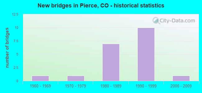
- New bridges - historical statistics
- 11960-1969
- 11970-1979
- 71980-1989
- 101990-1999
- 12000-2009


- Bridge Condition - Deck
- 11.1%Very good
- 16.7%Good
- 27.8%Satisfactory
- 33.3%Fair
- 11.1%Poor

- Bridge Condition - Superstructure
- 5.6%Very good
- 22.2%Good
- 44.4%Satisfactory
- 27.8%Fair

- Bridge Condition - Substructure
- 11.1%Very good
- 38.9%Good
- 50.0%Satisfactory

- Bridge Condition - Channel
- 10.0%Very good
- 70.0%Good
- 20.0%Satisfactory

- Bridge Condition - Culverts
- 50.0%Good
- 50.0%Satisfactory
Find on map >> Show street view
Structure Number: B-17-AZ, Location: 0.5 MI N OF PIERCE @ CR90 (Lat: 40.640286, Lng: -104.754053), Route carried "on" structure: US 85L, Year Built: 1971, Status: Open, Structure Length: 2.58m (8.46ft), Average Daily Traffic: 5,200 (year 2020), Truck Traffic: 12%, Average Future Daily Traffic: 6,552 (year 2040), Design Load: HS 20, Features Intersected: DRAW, Facility Carried by Structure: US 85 ML
Minimum Vertical Clearance: 30+ m (98+ ft), Kilometerpoint: 28.904, Lanes on structure: 7, Base Highway Network: Yes, Owner: State Highway Agency, Approaching Roadway Width: 29.9m (98.1ft), Material/Design: Concrete, Design/Construction: Culvert, Number Of Spans In Main Unit: 8, Length of Maximum Span: 3.0m (9.8ft), Out-to-Out Width: 34.4m (112.9ft)
Condition: Channel: Very good, Culverts: Satisfactory, Operating Rating: 36.3 metric tons, Method Used To Determine Operating Rating: Field evaluation and documented engineering judgment, Inventory Rating: 32.7 metric tons, Method Used To Determine Inventory Rating: Field evaluation and documented engineering judgment, Structural Evaluation: Equal to present minimum criteria, Waterway Adequacy: Equal to present desirable criteria, Approach Roadway Alignment: Equal to present desirable criteria, Designated Inspection Frequency: Every 24 months, Inspection Date: July 2021
Find on map >> Show street view
Structure Number: WEL029.0-084.0A, Location: 0.3 Mi N of Co Rd 84 (Lat: 40.598889, Lng: -104.792778), Route carried "on" structure: County highway , Year Built: 1990, Status: Open, Structure Length: 1.20m (3.94ft), Average Daily Traffic: 1,696 (year 2021), Truck Traffic: 26%, Average Future Daily Traffic: 2,408 (year 2041), Design Load: HS 20, Features Intersected: Collins Lateral Canal, Facility Carried by Structure: County Road 29
Minimum Vertical Clearance: 30+ m (98+ ft), Kilometerpoint: 16.320, Lanes on structure: 2, Owner: County Highway Agency, Approaching Roadway Width: 9.4m (30.8ft), Skew: 3 degrees, Material/Design: Steel, Design/Construction: Stringer/Multi-beam, Number Of Spans In Main Unit: 1, Length of Maximum Span: 11.2m (36.7ft), Curb-To-Curb Width: 9.5m (31.2ft), Out-to-Out Width: 9.8m (32.2ft)
Condition: Deck: Good, Superstructure: Satisfactory, Substructure: Good, Channel: Good, Operating Rating: 59.1 metric tons, Method Used To Determine Operating Rating: Load Factor (LF), Inventory Rating: 33.7 metric tons, Method Used To Determine Inventory Rating: Load Factor (LF), Structural Evaluation: Equal to present minimum criteria, Deck Geometry: Somewhat better than minimum adequacy, Waterway Adequacy: Equal to present desirable criteria, Approach Roadway Alignment: Equal to present desirable criteria, Designated Inspection Frequency: Every 24 months, Inspection Date: April 2020, Deck Structure Type: Corrugated Steel, Wearing Surface/Protective System: Wearing Surface: Gravel
Find on map >> Show street view
Structure Number: WEL029.0-084.0B, Location: 0.3 Mi N of Co Rd 84 (Lat: 40.601000, Lng: -104.792528), Route carried "on" structure: County highway , Year Built: 1992, Status: Open, Structure Length: 1.05m (3.44ft), Average Daily Traffic: 1,843 (year 2021), Truck Traffic: 31%, Average Future Daily Traffic: 2,617 (year 2041), Design Load: HS 20, Features Intersected: Collins Lateral Canal, Facility Carried by Structure: County Road 29
Minimum Vertical Clearance: 30+ m (98+ ft), Kilometerpoint: 16.561, Lanes on structure: 2, Owner: County Highway Agency, Approaching Roadway Width: 10.1m (33.1ft), Skew: 2 degrees, Material/Design: Steel, Design/Construction: Stringer/Multi-beam, Number Of Spans In Main Unit: 1, Length of Maximum Span: 9.8m (32.2ft), Curb-To-Curb Width: 10.1m (33.1ft), Out-to-Out Width: 10.3m (33.8ft)
Condition: Deck: Good, Superstructure: Satisfactory, Substructure: Satisfactory, Channel: Good, Operating Rating: 58.6 metric tons, Method Used To Determine Operating Rating: Load Factor (LF), Inventory Rating: 35.1 metric tons, Method Used To Determine Inventory Rating: Load Factor (LF), Structural Evaluation: Equal to present minimum criteria, Deck Geometry: Somewhat better than minimum adequacy, Waterway Adequacy: Equal to present desirable criteria, Approach Roadway Alignment: Equal to present desirable criteria, Designated Inspection Frequency: Every 24 months, Inspection Date: April 2020, Deck Structure Type: Corrugated Steel, Wearing Surface/Protective System: Wearing Surface: Gravel
Find on map >> Show street view
Structure Number: WEL029.0-088.0A, Location: 0.3 Mi N of Co Rd 88 (Lat: 40.629167, Lng: -104.792028), Route carried "on" structure: County highway , Year Built: 1990, Year Reconstructed: 2020, Status: Open, Structure Length: 0.66m (2.17ft), Average Daily Traffic: 1,426 (year 2021), Truck Traffic: 29%, Average Future Daily Traffic: 2,025 (year 2041), Design Load: HS 20, Features Intersected: Pierce Lateral Canal, Facility Carried by Structure: County Road 29
Minimum Vertical Clearance: 30+ m (98+ ft), Kilometerpoint: 19.698, Lanes on structure: 2, Owner: County Highway Agency, Approaching Roadway Width: 10.1m (33.1ft), Material/Design: Steel, Design/Construction: Stringer/Multi-beam, Number Of Spans In Main Unit: 1, Length of Maximum Span: 6.1m (20.0ft), Curb-To-Curb Width: 10.1m (33.1ft), Out-to-Out Width: 10.7m (35.1ft)
Condition: Deck: Very good, Superstructure: Good, Substructure: Good, Channel: Good, Operating Rating: 47.7 metric tons, Method Used To Determine Operating Rating: Load Factor (LF), Inventory Rating: 28.6 metric tons, Method Used To Determine Inventory Rating: Load Factor (LF), Structural Evaluation: Better than present minimum criteria, Deck Geometry: Somewhat better than minimum adequacy, Waterway Adequacy: Equal to present desirable criteria, Approach Roadway Alignment: Equal to present desirable criteria, Designated Inspection Frequency: Every 24 months, Inspection Date: Febuary 2022, Deck Structure Type: Corrugated Steel, Wearing Surface/Protective System: Wearing Surface: Bituminous
Find on map >> Show street view
Structure Number: WEL029.0-088.0B, Location: 0.7 Mi N of Co Rd 88 (Lat: 40.635556, Lng: -104.791972), Route carried "on" structure: County highway , Year Built: 1989, Year Reconstructed: 2020, Status: Open, Structure Length: 0.67m (2.20ft), Average Daily Traffic: 1,423 (year 2021), Truck Traffic: 30%, Average Future Daily Traffic: 2,021 (year 2041), Design Load: HS 20, Features Intersected: Pierce Lateral Canal, Facility Carried by Structure: County Road 29
Minimum Vertical Clearance: 30+ m (98+ ft), Kilometerpoint: 20.412, Lanes on structure: 2, Owner: County Highway Agency, Approaching Roadway Width: 10.4m (34.1ft), Skew: 2 degrees, Material/Design: Steel, Design/Construction: Stringer/Multi-beam, Number Of Spans In Main Unit: 1, Length of Maximum Span: 5.9m (19.4ft), Curb-To-Curb Width: 10.4m (34.1ft), Out-to-Out Width: 10.8m (35.4ft)
Condition: Deck: Good, Superstructure: Good, Substructure: Good, Channel: Satisfactory, Operating Rating: 42.2 metric tons, Method Used To Determine Operating Rating: Load Factor (LF), Inventory Rating: 25.3 metric tons, Method Used To Determine Inventory Rating: Load Factor (LF), Structural Evaluation: Equal to present minimum criteria, Deck Geometry: Equal to present minimum criteria, Waterway Adequacy: Equal to present desirable criteria, Approach Roadway Alignment: Equal to present desirable criteria, Designated Inspection Frequency: Every 24 months, Inspection Date: Febuary 2022, Deck Structure Type: Corrugated Steel, Wearing Surface/Protective System: Wearing Surface: Gravel
Find on map >> Show street view
Structure Number: WEL029.0-088.0C, Location: 0.9 Mi N of Co Rd 88 (Lat: 40.638833, Lng: -104.791917), Route carried "on" structure: County highway , Year Built: 1993, Year Reconstructed: 2020, Status: Open, Structure Length: 0.76m (2.49ft), Average Daily Traffic: 1,538 (year 2021), Truck Traffic: 32%, Average Future Daily Traffic: 2,184 (year 2041), Design Load: HS 20, Features Intersected: Pierce Lateral Canal, Facility Carried by Structure: County Road 29
Minimum Vertical Clearance: 30+ m (98+ ft), Kilometerpoint: 20.777, Lanes on structure: 2, Owner: County Highway Agency, Approaching Roadway Width: 9.8m (32.2ft), Skew: 3 degrees, Material/Design: Steel, Design/Construction: Stringer/Multi-beam, Number Of Spans In Main Unit: 1, Length of Maximum Span: 6.8m (22.3ft), Curb-To-Curb Width: 9.8m (32.2ft), Out-to-Out Width: 10.3m (33.8ft)
Condition: Deck: Very good, Superstructure: Very good, Substructure: Very good, Channel: Good, Operating Rating: 29.8 metric tons, Method Used To Determine Operating Rating: Load and Resistance Factor Rating (LRFR) rating reported by rating factor(RF) method using HL-93 loadings, Inventory Rating: 23.0 metric tons, Method Used To Determine Inventory Rating: Load and Resistance Factor Rating (LRFR) rating reported by rating factor(RF) method using HL-93 loadings, Structural Evaluation: Equal to present minimum criteria, Deck Geometry: Somewhat better than minimum adequacy, Waterway Adequacy: Equal to present desirable criteria, Approach Roadway Alignment: Equal to present desirable criteria, Designated Inspection Frequency: Every 24 months, Inspection Date: Febuary 2022, Deck Structure Type: Corrugated Steel, Wearing Surface/Protective System: Wearing Surface: Gravel
Find on map >> Show street view
Structure Number: WEL031.0-088.7A, Location: 0.1 Mi N of Co Rd 88.75 (Lat: 40.636944, Lng: -104.773056), Route carried "on" structure: County highway , Year Built: 1989, Status: Open, Structure Length: 0.80m (2.62ft), Average Daily Traffic: 123 (year 2021), Truck Traffic: 38%, Average Future Daily Traffic: 175 (year 2041), Design Load: HS 20, Features Intersected: Pierce Lateral Canal, Facility Carried by Structure: County Road 31
Minimum Vertical Clearance: 30+ m (98+ ft), Kilometerpoint: 18.113, Lanes on structure: 2, Owner: County Highway Agency, Approaching Roadway Width: 7.6m (24.9ft), Skew: 3 degrees, Material/Design: Steel, Design/Construction: Stringer/Multi-beam, Number Of Spans In Main Unit: 1, Length of Maximum Span: 7.2m (23.6ft), Curb-To-Curb Width: 9.6m (31.5ft), Out-to-Out Width: 9.7m (31.8ft)
Condition: Deck: Satisfactory, Superstructure: Good, Substructure: Good, Channel: Good, Operating Rating: 72.0 metric tons, Method Used To Determine Operating Rating: Load Factor (LF), Inventory Rating: 43.1 metric tons, Method Used To Determine Inventory Rating: Load Factor (LF), Structural Evaluation: Better than present minimum criteria, Deck Geometry: Equal to present minimum criteria, Waterway Adequacy: Equal to present desirable criteria, Approach Roadway Alignment: Equal to present desirable criteria, Designated Inspection Frequency: Every 24 months, Inspection Date: Febuary 2022, Deck Structure Type: Corrugated Steel, Wearing Surface/Protective System: Wearing Surface: Gravel
Find on map >> Show street view
Structure Number: WEL031.0_086.0A, Location: 0.1 Mi N of Co Rd 86 (Lat: 40.613250, Lng: -104.772944), Route carried "on" structure: County highway , Year Built: 1995, Status: Open, Structure Length: 0.84m (2.76ft), Average Daily Traffic: 221 (year 2021), Truck Traffic: 48%, Average Future Daily Traffic: 314 (year 2041), Design Load: HS 20, Features Intersected: Collins Lateral Canal, Facility Carried by Structure: County Road 31
Minimum Vertical Clearance: 30+ m (98+ ft), Kilometerpoint: 15.456, Lanes on structure: 2, Owner: County Highway Agency, Approaching Roadway Width: 7.3m (24.0ft), Skew: 4 degrees, Material/Design: Steel, Design/Construction: Stringer/Multi-beam, Number Of Spans In Main Unit: 1, Length of Maximum Span: 7.6m (24.9ft), Curb-To-Curb Width: 9.3m (30.5ft), Out-to-Out Width: 9.4m (30.8ft)
Condition: Deck: Satisfactory, Superstructure: Satisfactory, Substructure: Satisfactory, Channel: Very good, Operating Rating: 45.1 metric tons, Method Used To Determine Operating Rating: Load Factor (LF), Inventory Rating: 27.0 metric tons, Method Used To Determine Inventory Rating: Load Factor (LF), Structural Evaluation: Equal to present minimum criteria, Deck Geometry: Equal to present minimum criteria, Waterway Adequacy: Equal to present desirable criteria, Approach Roadway Alignment: Equal to present desirable criteria, Designated Inspection Frequency: Every 24 months, Inspection Date: Febuary 2022, Deck Structure Type: Corrugated Steel, Wearing Surface/Protective System: Wearing Surface: Gravel
Find on map >> Show street view
Structure Number: WEL033.0_086.0A, Location: 0.1 Mi. N. of Co. Rd. 86 (Lat: 40.611861, Lng: -104.753806), Route carried "on" structure: County highway , Year Built: 1996, Status: Open, Structure Length: 0.71m (2.33ft), Average Daily Traffic: 2,861 (year 2021), Truck Traffic: 14%, Average Future Daily Traffic: 4,063 (year 2041), Design Load: HS 20, Features Intersected: Collins Lateral Ditch, Facility Carried by Structure: County Road 33
Minimum Vertical Clearance: 30+ m (98+ ft), Kilometerpoint: 17.719, Lanes on structure: 2, Owner: County Highway Agency, Approaching Roadway Width: 7.6m (24.9ft), Skew: 3 degrees, Material/Design: Concrete, Design/Construction: Culvert, Number Of Spans In Main Unit: 1, Length of Maximum Span: 7.1m (23.3ft), Curb-To-Curb Width: 11.0m (36.1ft), Out-to-Out Width: 11.7m (38.4ft)
Condition: Channel: Good, Culverts: Good, Operating Rating: 36.3 metric tons, Method Used To Determine Operating Rating: Field evaluation and documented engineering judgment, Inventory Rating: 32.7 metric tons, Method Used To Determine Inventory Rating: Field evaluation and documented engineering judgment, Structural Evaluation: Better than present minimum criteria, Deck Geometry: Somewhat better than minimum adequacy, Waterway Adequacy: Equal to present desirable criteria, Approach Roadway Alignment: Equal to present desirable criteria, Designated Inspection Frequency: Every 24 months, Inspection Date: Febuary 2022, Deck Structure Type: Concrete Cast-file-Place, Wearing Surface/Protective System: Wearing Surface: Bituminous, Membrane: Preformed Fabric, Deck Protection: Epoxy Coated Reinforcing
Find on map >> Show street view
Structure Number: WEL037.0_086.0A, Location: 0.8 Mi N of Co Rd 86 (Lat: 40.621917, Lng: -104.715833), Route carried "on" structure: County highway , Year Built: 1998, Status: Open, Structure Length: 0.85m (2.79ft), Average Daily Traffic: 140 (year 2021), Truck Traffic: 29%, Average Future Daily Traffic: 199 (year 2041), Design Load: HS 20, Features Intersected: Collins Lateral Canal, Facility Carried by Structure: County Road 37
Minimum Vertical Clearance: 30+ m (98+ ft), Kilometerpoint: 8.749, Lanes on structure: 2, Owner: County Highway Agency, Approaching Roadway Width: 7.3m (24.0ft), Skew: 4 degrees, Material/Design: Steel, Design/Construction: Stringer/Multi-beam, Number Of Spans In Main Unit: 1, Length of Maximum Span: 7.4m (24.3ft), Curb-To-Curb Width: 9.6m (31.5ft), Out-to-Out Width: 9.8m (32.2ft)
Condition: Deck: Satisfactory, Superstructure: Good, Substructure: Very good, Channel: Good, Operating Rating: 52.5 metric tons, Method Used To Determine Operating Rating: Load Factor (LF), Inventory Rating: 31.6 metric tons, Method Used To Determine Inventory Rating: Load Factor (LF), Structural Evaluation: Better than present minimum criteria, Deck Geometry: Equal to present minimum criteria, Waterway Adequacy: Equal to present desirable criteria, Approach Roadway Alignment: Equal to present desirable criteria, Designated Inspection Frequency: Every 24 months, Inspection Date: Febuary 2022, Deck Structure Type: Corrugated Steel, Wearing Surface/Protective System: Wearing Surface: Gravel
Find on map >> Show street view
Structure Number: WEL084.0-029.0A, Location: 0.1 Mi E of Co Rd 29 (Lat: 40.596944, Lng: -104.790556), Route carried "on" structure: County highway , Year Built: 1987, Status: Open, Structure Length: 0.93m (3.05ft), Average Daily Traffic: 217 (year 2021), Truck Traffic: 35%, Average Future Daily Traffic: 308 (year 2041), Design Load: HS 20, Features Intersected: Collins Lateral Canal, Facility Carried by Structure: County Road 84
Minimum Vertical Clearance: 30+ m (98+ ft), Kilometerpoint: 12.989, Lanes on structure: 2, Owner: County Highway Agency, Approaching Roadway Width: 6.7m (22.0ft), Skew: 2 degrees, Material/Design: Steel, Design/Construction: Stringer/Multi-beam, Number Of Spans In Main Unit: 1, Length of Maximum Span: 8.5m (27.9ft), Curb-To-Curb Width: 8.3m (27.2ft), Out-to-Out Width: 8.7m (28.5ft)
Condition: Deck: Fair, Superstructure: Fair, Substructure: Satisfactory, Channel: Good, Operating Rating: 53.1 metric tons, Method Used To Determine Operating Rating: Load Factor (LF), Inventory Rating: 31.8 metric tons, Method Used To Determine Inventory Rating: Load Factor (LF), Structural Evaluation: Somewhat better than minimum adequacy, Deck Geometry: Somewhat better than minimum adequacy, Waterway Adequacy: Equal to present desirable criteria, Approach Roadway Alignment: Equal to present desirable criteria, Designated Inspection Frequency: Every 24 months, Inspection Date: April 2020, Deck Structure Type: Corrugated Steel, Wearing Surface/Protective System: Wearing Surface: Gravel
Find on map >> Show street view
Structure Number: WEL086.0-027.0A, Location: 1.7 Mi E of Co Rd 25 (Lat: 40.611111, Lng: -104.797778), Route carried "on" structure: County highway , Year Built: 1989, Status: Open, Structure Length: 0.68m (2.23ft), Average Daily Traffic: 156 (year 2021), Truck Traffic: 36%, Average Future Daily Traffic: 222 (year 2041), Design Load: HS 20, Features Intersected: Pierce Lateral Canal, Facility Carried by Structure: County Road 86
Minimum Vertical Clearance: 30+ m (98+ ft), Kilometerpoint: 2.873, Lanes on structure: 2, Owner: County Highway Agency, Approaching Roadway Width: 7.3m (24.0ft), Material/Design: Steel, Design/Construction: Stringer/Multi-beam, Number Of Spans In Main Unit: 1, Length of Maximum Span: 6.1m (20.0ft), Curb-To-Curb Width: 9.5m (31.2ft), Out-to-Out Width: 9.8m (32.2ft)
Condition: Deck: Fair, Superstructure: Satisfactory, Substructure: Satisfactory, Channel: Good, Operating Rating: 62.9 metric tons, Method Used To Determine Operating Rating: Load Factor (LF), Inventory Rating: 37.6 metric tons, Method Used To Determine Inventory Rating: Load Factor (LF), Structural Evaluation: Equal to present minimum criteria, Deck Geometry: Equal to present minimum criteria, Waterway Adequacy: Better than present minimum criteria, Approach Roadway Alignment: Equal to present desirable criteria, Designated Inspection Frequency: Every 24 months, Inspection Date: Febuary 2022, Deck Structure Type: Corrugated Steel, Wearing Surface/Protective System: Wearing Surface: Gravel
Find on map >> Show street view
Structure Number: WEL086.0-029.0A, Location: 0.6 Mi E of Co Rd 29 (Lat: 40.611194, Lng: -104.780389), Route carried "on" structure: County highway , Year Built: 1990, Status: Open, Structure Length: 0.69m (2.26ft), Average Daily Traffic: 177 (year 2021), Truck Traffic: 36%, Average Future Daily Traffic: 251 (year 2041), Design Load: HS 20, Features Intersected: Collins Lateral Canal, Facility Carried by Structure: County Road 86
Minimum Vertical Clearance: 30+ m (98+ ft), Kilometerpoint: 4.344, Lanes on structure: 2, Owner: County Highway Agency, Approaching Roadway Width: 7.6m (24.9ft), Skew: 1 degrees, Material/Design: Steel, Design/Construction: Stringer/Multi-beam, Number Of Spans In Main Unit: 1, Length of Maximum Span: 6.3m (20.7ft), Curb-To-Curb Width: 9.0m (29.5ft), Out-to-Out Width: 9.1m (29.9ft)
Condition: Deck: Fair, Superstructure: Satisfactory, Substructure: Satisfactory, Channel: Satisfactory, Operating Rating: 46.4 metric tons, Method Used To Determine Operating Rating: Load Factor (LF), Inventory Rating: 27.8 metric tons, Method Used To Determine Inventory Rating: Load Factor (LF), Structural Evaluation: Equal to present minimum criteria, Deck Geometry: Equal to present minimum criteria, Waterway Adequacy: Equal to present desirable criteria, Approach Roadway Alignment: Equal to present desirable criteria, Designated Inspection Frequency: Every 24 months, Inspection Date: Febuary 2022, Deck Structure Type: Corrugated Steel, Wearing Surface/Protective System: Wearing Surface: Gravel
Find on map >> Show street view
Structure Number: WEL086.0_033.0A, Location: 0.2 Mi E of Co Rd 33 (Lat: 40.611547, Lng: -104.748603), Route carried "on" structure: County highway , Year Built: 2006, Status: Open, Structure Length: 1.44m (4.72ft), Average Daily Traffic: 547 (year 2021), Truck Traffic: 31%, Average Future Daily Traffic: 777 (year 2041), Design Load: HS 20, Features Intersected: Collins Lateral Canal, Facility Carried by Structure: County Road 86
Minimum Vertical Clearance: 30+ m (98+ ft), Kilometerpoint: 7.059, Lanes on structure: 2, Owner: County Highway Agency, Approaching Roadway Width: 7.3m (24.0ft), Skew: 6 degrees, Material/Design: Steel, Design/Construction: Stringer/Multi-beam, Number Of Spans In Main Unit: 1, Length of Maximum Span: 12.5m (41.0ft), Curb-To-Curb Width: 10.5m (34.4ft), Out-to-Out Width: 10.7m (35.1ft)
Condition: Deck: Satisfactory, Superstructure: Satisfactory, Substructure: Good, Channel: Good, Operating Rating: 48.9 metric tons, Method Used To Determine Operating Rating: Load Factor (LF), Inventory Rating: 29.3 metric tons, Method Used To Determine Inventory Rating: Load Factor (LF), Structural Evaluation: Equal to present minimum criteria, Deck Geometry: Equal to present minimum criteria, Waterway Adequacy: Equal to present desirable criteria, Approach Roadway Alignment: Equal to present desirable criteria, Designated Inspection Frequency: Every 24 months, Inspection Date: Febuary 2022, Deck Structure Type: Corrugated Steel, Wearing Surface/Protective System: Wearing Surface: Bituminous
Find on map >> Show street view
Structure Number: WEL088.0_027.0A, Location: 0.1 Mi W of Co Rd 29 (Lat: 40.625667, Lng: -104.793306), Route carried "on" structure: County highway , Year Built: 1994, Status: Open, Structure Length: 0.69m (2.26ft), Average Daily Traffic: 247 (year 2021), Truck Traffic: 16%, Average Future Daily Traffic: 351 (year 2041), Design Load: HS 20, Features Intersected: Pierce Lateral Canal, Facility Carried by Structure: County Road 88
Minimum Vertical Clearance: 30+ m (98+ ft), Kilometerpoint: 3.215, Lanes on structure: 2, Owner: County Highway Agency, Approaching Roadway Width: 7.0m (23.0ft), Skew: 1 degrees, Material/Design: Steel, Design/Construction: Stringer/Multi-beam, Number Of Spans In Main Unit: 1, Length of Maximum Span: 6.1m (20.0ft), Curb-To-Curb Width: 9.3m (30.5ft), Out-to-Out Width: 9.5m (31.2ft)
Condition: Deck: Fair, Superstructure: Satisfactory, Substructure: Satisfactory, Channel: Good, Operating Rating: 44.5 metric tons, Method Used To Determine Operating Rating: Load Factor (LF), Inventory Rating: 26.6 metric tons, Method Used To Determine Inventory Rating: Load Factor (LF), Structural Evaluation: Equal to present minimum criteria, Deck Geometry: Equal to present minimum criteria, Waterway Adequacy: Equal to present desirable criteria, Approach Roadway Alignment: Equal to present desirable criteria, Designated Inspection Frequency: Every 24 months, Inspection Date: Febuary 2022, Deck Structure Type: Corrugated Steel, Wearing Surface/Protective System: Wearing Surface: Gravel
Find on map >> Show street view
Structure Number: WEL090.0-023.0A, Location: 0.3 Mi E of Co Rd 23 (Lat: 40.639806, Lng: -104.842556), Route carried "on" structure: County highway , Year Built: 1980, Status: Open, Structure Length: 1.18m (3.87ft), Average Daily Traffic: 215 (year 2021), Truck Traffic: 37%, Average Future Daily Traffic: 305 (year 2041), Features Intersected: Coalbank Creek, Facility Carried by Structure: County Road 90
Minimum Vertical Clearance: 30+ m (98+ ft), Kilometerpoint: 8.578, Lanes on structure: 2, Owner: County Highway Agency, Approaching Roadway Width: 7.3m (24.0ft), Material/Design: Steel, Design/Construction: Stringer/Multi-beam, Number Of Spans In Main Unit: 1, Length of Maximum Span: 11.1m (36.4ft), Curb-To-Curb Width: 9.2m (30.2ft), Out-to-Out Width: 9.7m (31.8ft)
Condition: Deck: Satisfactory, Superstructure: Satisfactory, Substructure: Good, Channel: Good, Operating Rating: 53.7 metric tons, Method Used To Determine Operating Rating: Load Factor (LF), Inventory Rating: 32.1 metric tons, Method Used To Determine Inventory Rating: Load Factor (LF), Structural Evaluation: Equal to present minimum criteria, Deck Geometry: Equal to present minimum criteria, Waterway Adequacy: Better than present minimum criteria, Approach Roadway Alignment: Equal to present desirable criteria, Designated Inspection Frequency: Every 24 months, Inspection Date: April 2020, Deck Structure Type: Corrugated Steel, Wearing Surface/Protective System: Wearing Surface: Gravel
Find on map >> Show street view
Structure Number: WEL090.0-029.0A, Location: 0.2 Mi E of Co Rd 29 (Lat: 40.640278, Lng: -104.787667), Route carried "on" structure: County highway , Year Built: 1993, Status: Open, Structure Length: 0.93m (3.05ft), Average Daily Traffic: 1,003 (year 2021), Truck Traffic: 38%, Average Future Daily Traffic: 1,424 (year 2041), Design Load: HS 20, Features Intersected: Pierce Lateral Canal, Facility Carried by Structure: County Road 90
Minimum Vertical Clearance: 30+ m (98+ ft), Kilometerpoint: 0.359, Lanes on structure: 2, Owner: City or Municipal Highway Agency, Approaching Roadway Width: 7.3m (24.0ft), Skew: 1 degrees, Material/Design: Steel, Design/Construction: Stringer/Multi-beam, Number Of Spans In Main Unit: 1, Length of Maximum Span: 8.2m (26.9ft), Curb-To-Curb Width: 9.3m (30.5ft), Out-to-Out Width: 9.6m (31.5ft)
Condition: Deck: Poor, Superstructure: Fair, Substructure: Satisfactory, Channel: Satisfactory, Operating Rating: 47.0 metric tons, Method Used To Determine Operating Rating: Load Factor (LF), Inventory Rating: 28.2 metric tons, Method Used To Determine Inventory Rating: Load Factor (LF), Structural Evaluation: Somewhat better than minimum adequacy, Deck Geometry: Somewhat better than minimum adequacy, Waterway Adequacy: Equal to present desirable criteria, Approach Roadway Alignment: Equal to present desirable criteria, Designated Inspection Frequency: Every 12 months, Inspection Date: Febuary 2022, Deck Structure Type: Corrugated Steel, Wearing Surface/Protective System: Wearing Surface: Bituminous
Find on map >> Show street view
Structure Number: WEL090.0-029.1B, Location: 0.7 Mi E of Co Rd 29 (Lat: 40.640250, Lng: -104.778444), Route carried "on" structure: County highway , Year Built: 1989, Status: Open, Structure Length: 0.73m (2.40ft), Average Daily Traffic: 1,058 (year 2021), Truck Traffic: 33%, Average Future Daily Traffic: 1,502 (year 2041), Design Load: HS 20, Features Intersected: Pierce Lateral Canal, Facility Carried by Structure: County Road 90
Minimum Vertical Clearance: 30+ m (98+ ft), Kilometerpoint: 1.143, Lanes on structure: 2, Owner: City or Municipal Highway Agency, Approaching Roadway Width: 7.3m (24.0ft), Skew: 3 degrees, Material/Design: Steel, Design/Construction: Stringer/Multi-beam, Number Of Spans In Main Unit: 1, Length of Maximum Span: 6.4m (21.0ft), Curb-To-Curb Width: 9.5m (31.2ft), Out-to-Out Width: 9.7m (31.8ft)
Condition: Deck: Poor, Superstructure: Fair, Substructure: Satisfactory, Channel: Good, Operating Rating: 34.3 metric tons, Method Used To Determine Operating Rating: Load Factor (LF), Inventory Rating: 20.6 metric tons, Method Used To Determine Inventory Rating: Load Factor (LF), Structural Evaluation: Somewhat better than minimum adequacy, Deck Geometry: Somewhat better than minimum adequacy, Waterway Adequacy: Equal to present desirable criteria, Approach Roadway Alignment: Equal to present desirable criteria, Designated Inspection Frequency: Every 12 months, Inspection Date: Febuary 2022, Deck Structure Type: Corrugated Steel, Wearing Surface/Protective System: Wearing Surface: Bituminous
Find on map >> Show street view
Structure Number: WEL090.0-031.0A, Location: 0.5 Mi E of Co Rd 31 (Lat: 40.640167, Lng: -104.763583), Route carried "on" structure: County highway , Year Built: 1982, Status: Open, Structure Length: 0.79m (2.59ft), Average Daily Traffic: 1,103 (year 2021), Truck Traffic: 30%, Average Future Daily Traffic: 1,566 (year 2041), Design Load: HS 20, Features Intersected: Pierce Lateral Canal, Facility Carried by Structure: County Road 90
Minimum Vertical Clearance: 30+ m (98+ ft), Kilometerpoint: 2.404, Lanes on structure: 2, Owner: City or Municipal Highway Agency, Approaching Roadway Width: 7.3m (24.0ft), Skew: 5 degrees, Material/Design: Steel, Design/Construction: Stringer/Multi-beam, Number Of Spans In Main Unit: 1, Length of Maximum Span: 6.9m (22.6ft), Curb-To-Curb Width: 10.0m (32.8ft), Out-to-Out Width: 10.0m (32.8ft)
Condition: Deck: Fair, Superstructure: Fair, Substructure: Good, Channel: Satisfactory, Operating Rating: 26.0 metric tons, Method Used To Determine Operating Rating: Load Factor (LF), Inventory Rating: 15.6 metric tons, Method Used To Determine Inventory Rating: Load Factor (LF), Structural Evaluation: Meets minimum limits, Deck Geometry: Somewhat better than minimum adequacy, Waterway Adequacy: Equal to present desirable criteria, Approach Roadway Alignment: Equal to present desirable criteria, Designated Inspection Frequency: Every 24 months, Inspection Date: Febuary 2022, Deck Structure Type: Corrugated Steel, Wearing Surface/Protective System: Wearing Surface: Bituminous
Find on map >> Show street view
Structure Number: WEL090.0-031.0B, Location: 200 Ft E of US Hwy 85 (Lat: 40.640139, Lng: -104.753194), Route carried "on" structure: County highway , Year Built: 1960, Status: Open, Structure Length: 0.94m (3.08ft), Average Daily Traffic: 2,562 (year 2021), Truck Traffic: 31%, Average Future Daily Traffic: 3,638 (year 2041), Features Intersected: Spring Creek, Facility Carried by Structure: County Road 90
Minimum Vertical Clearance: 30+ m (98+ ft), Kilometerpoint: 0.463, Lanes on structure: 2, Owner: County Highway Agency, Approaching Roadway Width: 7.6m (24.9ft), Material/Design: Prestressed concrete, Design/Construction: Tee Beam, Number Of Spans In Main Unit: 1, Length of Maximum Span: 8.6m (28.2ft), Curb-To-Curb Width: 9.0m (29.5ft), Out-to-Out Width: 9.2m (30.2ft)
Condition: Deck: Fair, Superstructure: Fair, Substructure: Satisfactory, Channel: Good, Operating Rating: 36.3 metric tons, Method Used To Determine Operating Rating: Field evaluation and documented engineering judgment, Inventory Rating: 32.7 metric tons, Method Used To Determine Inventory Rating: Field evaluation and documented engineering judgment, Structural Evaluation: Somewhat better than minimum adequacy, Deck Geometry: Meets minimum limits, Waterway Adequacy: Equal to present desirable criteria, Approach Roadway Alignment: Equal to present desirable criteria, Designated Inspection Frequency: Every 24 months, Inspection Date: April 2020, Deck Structure Type: Other, Wearing Surface/Protective System: Wearing Surface: Bituminous