Bridge Statistics for Phillipsburg, New Jersey (NJ)
Condition, Traffic, Stress, Structural Evaluation, Project Costs
- National Bridge Inventory (NBI) Statistics
- 23Number of bridges
- 489ft / 149mTotal length
- $10,689,000Total costs
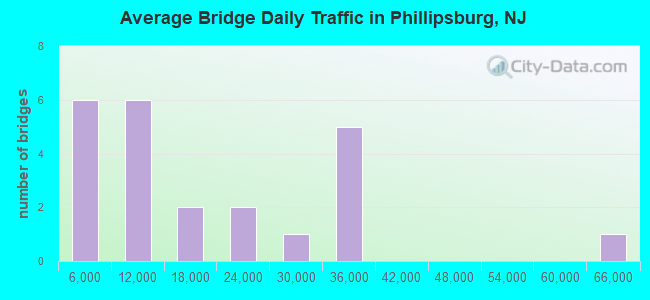
- 383,096Total average daily traffic
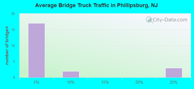
- 41,699Total average daily truck traffic
- National Bridge Inventory (NBI) Registered Bridges for Phillipsburg
- No street view available for this location
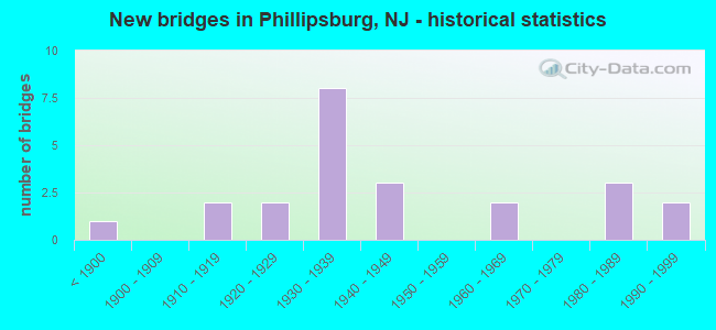
- New bridges - historical statistics
- 1Before 1900
- 21910-1919
- 21920-1929
- 81930-1939
- 31940-1949
- 21960-1969
- 31980-1989
- 21990-1999
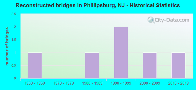
- Reconstructed bridges - Historical Statistics
- 11960-1969
- 01970-1979
- 11980-1989
- 21990-1999
- 12000-2009
- 12010-2019
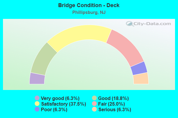
- Bridge Condition - Deck
- 6.3%Very good
- 18.8%Good
- 37.5%Satisfactory
- 25.0%Fair
- 6.3%Poor
- 6.3%Serious
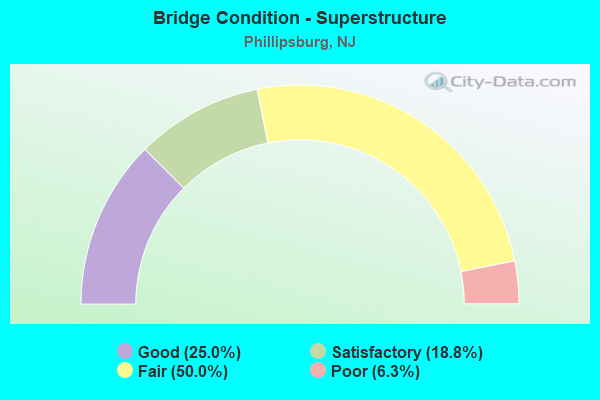
- Bridge Condition - Superstructure
- 25.0%Good
- 18.8%Satisfactory
- 50.0%Fair
- 6.3%Poor
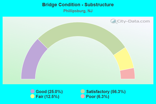
- Bridge Condition - Substructure
- 25.0%Good
- 56.3%Satisfactory
- 12.5%Fair
- 6.3%Poor
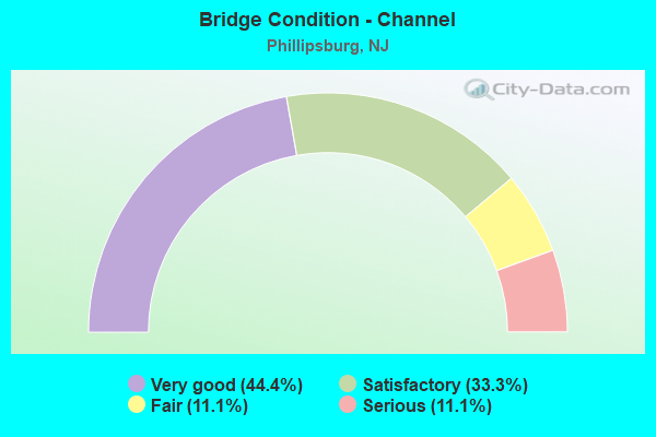
- Bridge Condition - Channel
- 44.4%Very good
- 33.3%Satisfactory
- 11.1%Fair
- 11.1%Serious
Find on map >> Show street view
Structure Number: 210115, Location: 0.6 MI EAST OF DELAWARE R (Lat: 40.696619, Lng: -75.193319), Route carried "on" structure: US 22, Year Built: 1961, Year Reconstructed: 2018, Status: Open, Structure Length: 2.71m (8.89ft), Average Daily Traffic: 19,986 (year 2021), Truck Traffic: 4%, Average Future Daily Traffic: 24,386 (year 2041), Design Load: HL 93, Features Intersected: MEMORIAL PARKWAY EB
Minimum Vertical Clearance: 30+ m (98+ ft), Kilometerpoint: 0.933, Lanes on structure: 2, Lanes under structure: 1, Base Highway Network: Yes, Owner: State Highway Agency, Approaching Roadway Width: 10.7m (35.1ft), Skew: 6 degrees, Material/Design: Steel, Design/Construction: Stringer/Multi-beam, Number Of Spans In Main Unit: 1, Length of Maximum Span: 25.9m (85.0ft), Curb-To-Curb Width: 11.8m (38.7ft), Out-to-Out Width: 12.9m (42.3ft)
Condition: Deck: Very good, Superstructure: Good, Substructure: Good, Operating Rating: 96.9 metric tons, Method Used To Determine Operating Rating: Load and Resistance Factor Rating (LRFR) rating reported by rating factor(RF) method using HL-93 loadings, Inventory Rating: 80.7 metric tons, Method Used To Determine Inventory Rating: Load and Resistance Factor Rating (LRFR) rating reported by rating factor(RF) method using HL-93 loadings, Structural Evaluation: Better than present minimum criteria, Deck Geometry: Equal to present minimum criteria, Underclear: Meets minimum limits, Approach Roadway Alignment: Equal to present desirable criteria, Length Of Structure Improvement: 2.77m (9.09ft), Designated Inspection Frequency: Every 24 months, Inspection Date: March 2021, Bridge Improvement Cost: $535,000, Roadway Improvement Cost: $100,000, Total Project Cost: $911,000 ( Estimate for 2015), Deck Structure Type: Concrete Cast-file-Place, Wearing Surface/Protective System: Wearing Surface: Bituminous
Find on map >> Show street view
Structure Number: 2101152, Location: AT 22-57 JCT (Lat: 40.699161, Lng: -75.164311), Route carried "on" structure: US 22, Year Built: 1939, Status: Open, Structure Length: 1.62m (5.31ft), Average Daily Traffic: 15,000 (year 2021), Truck Traffic: 4%, Average Future Daily Traffic: 18,000 (year 2041), Features Intersected: NJ 57 EASTBOUND
Minimum Vertical Clearance: 30+ m (98+ ft), Kilometerpoint: 3.396, Lanes on structure: 2, Lanes under structure: 2, Base Highway Network: Yes, Owner: State Highway Agency, Approaching Roadway Width: 7.3m (24.0ft), Skew: 4 degrees, Material/Design: Steel, Design/Construction: Stringer/Multi-beam, Number Of Spans In Main Unit: 1, Length of Maximum Span: 15.2m (49.9ft), Curb or Sidewalk Widths: Left: 0.8m (2.6ft), Right: 1.8m (5.9ft), Curb-To-Curb Width: 7.4m (24.3ft), Out-to-Out Width: 10.5m (34.4ft)
Condition: Deck: Fair, Superstructure: Satisfactory, Substructure: Satisfactory, Operating Rating: 47.2 metric tons, Method Used To Determine Operating Rating: Load Factor (LF), Inventory Rating: 28.1 metric tons, Method Used To Determine Inventory Rating: Load Factor (LF), Structural Evaluation: Equal to present minimum criteria, Deck Geometry: High priority of replacement, Underclear: High priority of replacement, Approach Roadway Alignment: Meets minimum limits, Length Of Structure Improvement: 2.26m (7.41ft), Designated Inspection Frequency: Every 24 months, Inspection Date: October 2021, Bridge Improvement Cost: $1,466,000, Roadway Improvement Cost: $50,000, Total Project Cost: $2,116,000 ( Estimate for 2021), Deck Structure Type: Concrete Cast-file-Place, Wearing Surface/Protective System: Wearing Surface: Bituminous, Membrane: Other
Find on map >> Show street view
Structure Number: 2101153, Location: .6 MI EAST OF DELAWARE R (Lat: 40.695989, Lng: -75.192169), Route carried "on" structure: Ramp US 22, Year Built: 1945, Status: Open, Structure Length: 1.77m (5.81ft), Average Daily Traffic: 3,050 (year 2021), Truck Traffic: 4%, Average Future Daily Traffic: 3,660 (year 2041), Design Load: H 20, Features Intersected: US 22 EB, Facility Carried by Structure: Ramp to Morris St
Minimum Vertical Clearance: 30+ m (98+ ft), Kilometerpoint: 1.030, Lanes on structure: 1, Lanes under structure: 3, Owner: State Highway Agency, Approaching Roadway Width: 7.3m (24.0ft), Skew: 2 degrees, Material/Design: Concrete, Design/Construction: Tee Beam, Number Of Spans In Main Unit: 1, Length of Maximum Span: 17.1m (56.1ft), Curb or Sidewalk Widths: Left: 2.5m (8.2ft), Right: 0.8m (2.6ft), Curb-To-Curb Width: 7.3m (24.0ft), Out-to-Out Width: 11.4m (37.4ft)
Condition: Deck: Fair, Superstructure: Fair, Substructure: Satisfactory, Operating Rating: 56.2 metric tons, Method Used To Determine Operating Rating: Load Factor (LF), Inventory Rating: 33.6 metric tons, Method Used To Determine Inventory Rating: Load Factor (LF), Structural Evaluation: Somewhat better than minimum adequacy, Deck Geometry: Better than present minimum criteria, Underclear: High priority of replacement, Approach Roadway Alignment: Equal to present minimum criteria, Length Of Structure Improvement: 2.50m (8.20ft), Designated Inspection Frequency: Every 24 months, Inspection Date: October 2021, Bridge Improvement Cost: $1,097,000, Roadway Improvement Cost: $53,000, Total Project Cost: $1,611,000 ( Estimate for 2021), Deck Structure Type: Concrete Cast-file-Place
Find on map >> Show street view
Structure Number: 2101154, Location: 2 MI EAST OF DELAWARE RIV (Lat: 40.698800, Lng: -75.164769), Route carried "on" structure: US 22, Year Built: 1939, Status: Open, Structure Length: 4.18m (13.71ft), Average Daily Traffic: 30,009 (year 2021), Truck Traffic: 4%, Average Future Daily Traffic: 36,011 (year 2041), Design Load: H 20, Features Intersected: NORFOLK SOUTHERN RR
Minimum Vertical Clearance: 30+ m (98+ ft), Kilometerpoint: 3.407, Lanes on structure: 2, Base Highway Network: Yes, Owner: State Highway Agency, Approaching Roadway Width: 7.3m (24.0ft), Skew: 4 degrees, Material/Design: Steel, Design/Construction: Stringer/Multi-beam, Number Of Spans In Main Unit: 3, Length of Maximum Span: 17.4m (57.1ft), Curb or Sidewalk Widths: Left: 0.4m (1.3ft), Right: 1.9m (6.2ft), Curb-To-Curb Width: 7.3m (24.0ft), Out-to-Out Width: 10.3m (33.8ft)
Condition: Deck: Satisfactory, Superstructure: Satisfactory, Substructure: Fair, Operating Rating: 43.5 metric tons, Method Used To Determine Operating Rating: Load Factor (LF), Inventory Rating: 26.3 metric tons, Method Used To Determine Inventory Rating: Load Factor (LF), Structural Evaluation: Somewhat better than minimum adequacy, Deck Geometry: High priority of replacement, Underclear: Meets minimum limits, Approach Roadway Alignment: Somewhat better than minimum adequacy, Length Of Structure Improvement: 4.18m (13.71ft), Designated Inspection Frequency: Every 24 months, Inspection Date: March 2021, Bridge Improvement Cost: $666,000, Roadway Improvement Cost: $56,000, Total Project Cost: $1,043,000 ( Estimate for 2021), Deck Structure Type: Concrete Cast-file-Place, Wearing Surface/Protective System: Wearing Surface: Bituminous, Membrane: Built-up
Find on map >> Show street view
Structure Number: 2101155, Location: .06 MI EAST OF NJ 57 (Lat: 40.698939, Lng: -75.164250), Route carried "on" structure: US 22, Year Built: 1939, Status: Open, Structure Length: 3.29m (10.79ft), Average Daily Traffic: 24,405 (year 2021), Truck Traffic: 4%, Average Future Daily Traffic: 29,285 (year 2041), Features Intersected: WASH SEC NORFOLKSOUTHERN
Minimum Vertical Clearance: 30+ m (98+ ft), Kilometerpoint: 3.428, Lanes on structure: 2, Base Highway Network: Yes, Owner: State Highway Agency, Approaching Roadway Width: 7.3m (24.0ft), Skew: 2 degrees, Material/Design: Steel, Design/Construction: Stringer/Multi-beam, Number Of Spans In Main Unit: 3, Length of Maximum Span: 11.9m (39.0ft), Curb or Sidewalk Widths: Left: 1.9m (6.2ft), Right: 0.4m (1.3ft), Curb-To-Curb Width: 7.3m (24.0ft), Out-to-Out Width: 10.2m (33.5ft)
Condition: Deck: Satisfactory, Superstructure: Satisfactory, Substructure: Fair, Operating Rating: 39.0 metric tons, Method Used To Determine Operating Rating: Load Factor (LF), Inventory Rating: 22.7 metric tons, Method Used To Determine Inventory Rating: Load Factor (LF), Structural Evaluation: Somewhat better than minimum adequacy, Deck Geometry: High priority of replacement, Underclear: Meets minimum limits, Approach Roadway Alignment: Equal to present minimum criteria, Length Of Structure Improvement: 3.29m (10.79ft), Designated Inspection Frequency: Every 24 months, Inspection Date: July 2021, Bridge Improvement Cost: $207,000, Roadway Improvement Cost: $21,000, Total Project Cost: $333,000 ( Estimate for 2019), Deck Structure Type: Concrete Cast-file-Place, Wearing Surface/Protective System: Wearing Surface: Bituminous, Membrane: Other
Find on map >> Show street view
Structure Number: 2101515, Location: 0.5 MI SOUTH US 22 (Lat: 40.690181, Lng: -75.158189), Route carried "on" structure: City street , Year Built: 1946, Status: Open, Structure Length: 1.37m (4.49ft), Average Daily Traffic: 420 (year 2021), Truck Traffic: 1%, Average Future Daily Traffic: 500 (year 2041), Features Intersected: LOPATCONG CREEK, Facility Carried by Structure: LOCK STREET
Minimum Vertical Clearance: 30+ m (98+ ft), Kilometerpoint: 0.000, Lanes on structure: 2, Owner: County Highway Agency, Approaching Roadway Width: 6.7m (22.0ft), Skew: 3 degrees, Material/Design: Steel, Design/Construction: Stringer/Multi-beam, Number Of Spans In Main Unit: 1, Length of Maximum Span: 12.5m (41.0ft), Curb or Sidewalk Widths: Left: 0.1m (0.3ft), Right: 0.1m (0.3ft), Curb-To-Curb Width: 8.5m (27.9ft), Out-to-Out Width: 9.6m (31.5ft)
Condition: Deck: Fair, Superstructure: Fair, Substructure: Satisfactory, Channel: Fair, Operating Rating: 39.0 metric tons, Method Used To Determine Operating Rating: Load Factor (LF), Inventory Rating: 23.6 metric tons, Method Used To Determine Inventory Rating: Load Factor (LF), Structural Evaluation: Somewhat better than minimum adequacy, Deck Geometry: Somewhat better than minimum adequacy, Waterway Adequacy: Better than present minimum criteria, Approach Roadway Alignment: Equal to present desirable criteria, Designated Inspection Frequency: Every 24 months, Inspection Date: March 2021, Deck Structure Type: Concrete Cast-file-Place, Wearing Surface/Protective System: Wearing Surface: Bituminous
Find on map >> Show street view
Structure Number: 2101531, Location: 1 Mi N of US22 & NJ57 Jct (Lat: 40.719361, Lng: -75.164000), Route carried "on" structure: City street , Year Built: 1999, Status: Open, Structure Length: 0.70m (2.30ft), Average Daily Traffic: 377 (year 2021), Truck Traffic: 1%, Average Future Daily Traffic: 461 (year 2041), Design Load: HS 25 or greater, Features Intersected: TRIB TO LOPATCONG CREEK, Facility Carried by Structure: JADE DRIVE
Minimum Vertical Clearance: 30+ m (98+ ft), Kilometerpoint: 0.000, Lanes on structure: 2, Owner: County Highway Agency, Approaching Roadway Width: 9.1m (29.9ft), Skew: 3 degrees, Material/Design: Concrete, Design/Construction: Culvert, Number Of Spans In Main Unit: 1, Length of Maximum Span: 7.0m (23.0ft), Curb or Sidewalk Widths: Left: 2.9m (9.5ft), Right: 2.9m (9.5ft), Curb-To-Curb Width: 9.1m (29.9ft), Out-to-Out Width: 15.8m (51.8ft)
Condition: Channel: Very good, Culverts: Satisfactory, Structural Evaluation: Equal to present minimum criteria, Deck Geometry: Equal to present minimum criteria, Waterway Adequacy: Superior to present desirable criteria, Approach Roadway Alignment: Equal to present desirable criteria, Designated Inspection Frequency: Every 24 months, Inspection Date: April 2021
Find on map >> Show street view
Structure Number: 2101902, Location: 0.01 MI.NORTH OF RT.NJ122 (Lat: 40.677250, Lng: -75.166631), Route carried "on" structure: City street , Year Built: 1926, Status: Open, Structure Length: 1.07m (3.51ft), Average Daily Traffic: 2,304 (year 2021), Truck Traffic: 4%, Average Future Daily Traffic: 2,811 (year 2041), Features Intersected: LOPATCONG CREEK, Facility Carried by Structure: LOCK STREET
Minimum Vertical Clearance: 30+ m (98+ ft), Kilometerpoint: 0.016, Lanes on structure: 2, Owner: County Highway Agency, Approaching Roadway Width: 9.1m (29.9ft), Material/Design: Steel, Design/Construction: Stringer/Multi-beam, Number Of Spans In Main Unit: 1, Length of Maximum Span: 9.4m (30.8ft), Curb or Sidewalk Widths: Left: 1.2m (3.9ft), Right: 1.4m (4.6ft), Curb-To-Curb Width: 9.1m (29.9ft), Out-to-Out Width: 12.3m (40.4ft)
Condition: Deck: Fair, Superstructure: Fair, Substructure: Satisfactory, Channel: Satisfactory, Operating Rating: 47.2 metric tons, Method Used To Determine Operating Rating: Load Factor (LF), Inventory Rating: 28.1 metric tons, Method Used To Determine Inventory Rating: Load Factor (LF), Structural Evaluation: Somewhat better than minimum adequacy, Deck Geometry: Meets minimum limits, Waterway Adequacy: Better than present minimum criteria, Approach Roadway Alignment: Meets minimum limits, Designated Inspection Frequency: Every 24 months, Inspection Date: April 2021, Deck Structure Type: Concrete Cast-file-Place, Wearing Surface/Protective System: Wearing Surface: Bituminous
Find on map >> Show street view
Structure Number: 2101903, Location: 0.55 MI WEST OF CR 519 (Lat: 40.677339, Lng: -75.169761), Route carried "on" structure: County highway 678, Year Built: 1925, Year Reconstructed: 1967, Status: Open, Structure Length: 1.46m (4.79ft), Average Daily Traffic: 8,380 (year 2021), Truck Traffic: 4%, Average Future Daily Traffic: 10,000 (year 2041), Features Intersected: LOPATCONG CREEK
Minimum Vertical Clearance: 30+ m (98+ ft), Kilometerpoint: 0.966, Lanes on structure: 3, Base Highway Network: Yes, Owner: County Highway Agency, Approaching Roadway Width: 14.9m (48.9ft), Skew: 5 degrees, Material/Design: Steel, Design/Construction: Stringer/Multi-beam, Number Of Spans In Main Unit: 1, Length of Maximum Span: 12.5m (41.0ft), Curb or Sidewalk Widths: Left: 0.8m (2.6ft), Right: 0.3m (1.0ft), Curb-To-Curb Width: 15.0m (49.2ft), Out-to-Out Width: 16.9m (55.4ft)
Condition: Deck: Poor, Superstructure: Fair, Substructure: Satisfactory, Channel: Serious, Operating Rating: 29.0 metric tons, Method Used To Determine Operating Rating: Load Factor (LF), Inventory Rating: 17.2 metric tons, Method Used To Determine Inventory Rating: Load Factor (LF), Structural Evaluation: Meets minimum limits, Deck Geometry: Equal to present minimum criteria, Waterway Adequacy: Superior to present desirable criteria, Approach Roadway Alignment: Equal to present minimum criteria, Length Of Structure Improvement: 2.13m (6.99ft), Designated Inspection Frequency: Every 24 months, Inspection Date: March 2021, Bridge Improvement Cost: $1,452,000, Roadway Improvement Cost: $50,000, Total Project Cost: $1,850,000 ( Estimate for 2021), Deck Structure Type: Concrete Cast-file-Place, Wearing Surface/Protective System: Wearing Surface: Bituminous
Find on map >> Show street view
Structure Number: 2101905, Location: 0.9 MI S OF US-22 JCT (Lat: 40.684600, Lng: -75.162419), Route carried "on" structure: City street , Year Built: 1994, Status: Open, Structure Length: 2.68m (8.79ft), Average Daily Traffic: 410 (year 2021), Truck Traffic: 1%, Average Future Daily Traffic: 490 (year 2041), Design Load: HS 20+Mod, Features Intersected: LOPATCONG CREEK, Facility Carried by Structure: LOCK STREET
Minimum Vertical Clearance: 30+ m (98+ ft), Kilometerpoint: 0.000, Lanes on structure: 2, Owner: County Highway Agency, Approaching Roadway Width: 6.4m (21.0ft), Skew: 3 degrees, Material/Design: Steel, Design/Construction: Truss - Thru, Number Of Spans In Main Unit: 1, Length of Maximum Span: 25.0m (82.0ft), Curb-To-Curb Width: 6.6m (21.7ft), Out-to-Out Width: 7.2m (23.6ft)
Condition: Deck: Satisfactory, Superstructure: Fair, Substructure: Good, Channel: Satisfactory, Operating Rating: 29.9 metric tons, Method Used To Determine Operating Rating: Load Factor (LF), Inventory Rating: 18.1 metric tons, Method Used To Determine Inventory Rating: Load Factor (LF), Structural Evaluation: Somewhat better than minimum adequacy, Deck Geometry: High priority of corrective action, Waterway Adequacy: Equal to present desirable criteria, Approach Roadway Alignment: Equal to present minimum criteria, Length Of Structure Improvement: 2.68m (8.79ft), Designated Inspection Frequency: Every 24 months, Critical Feature Inspection Frequency: Every 24 months, Inspection Date: April 2021, Critical Feature Inspection Date: April 2021, Bridge Improvement Cost: $18,000, Total Project Cost: $28,000 ( Estimate for 2021), Deck Structure Type: Wood or Timber, Wearing Surface/Protective System: Wearing Surface: Bituminous, Membrane: Preformed Fabric
Find on map >> Show street view
Structure Number: 215416, Location: 0.55MI SE PA611&US22 JCT (Lat: 40.688481, Lng: -75.198919), Route carried "on" structure: Alternate City street , Year Built: 1910, Status: Open, Structure Length: 1.62m (5.31ft), Average Daily Traffic: 8,836 (year 2021), Truck Traffic: 4%, Average Future Daily Traffic: 10,782 (year 2041), Features Intersected: Washington Sec (Conrail), Facility Carried by Structure: South Main Street
Minimum Vertical Clearance: 30+ m (98+ ft), Kilometerpoint: 0.612, Lanes on structure: 2, Base Highway Network: Yes, Maintenance Responsibility: State Highway Agency, Approaching Roadway Width: 11.0m (36.1ft), Skew: 4 degrees, Material/Design: Steel, Design/Construction: Stringer/Multi-beam, Number Of Spans In Main Unit: 2, Length of Maximum Span: 8.8m (28.9ft), Curb or Sidewalk Widths: Left: 3.6m (11.8ft), Right: 3.6m (11.8ft), Curb-To-Curb Width: 11.0m (36.1ft), Out-to-Out Width: 18.6m (61.0ft)
Condition: Deck: Serious, Superstructure: Poor, Substructure: Poor, Operating Rating: 55.3 metric tons, Method Used To Determine Operating Rating: Load Factor (LF), Inventory Rating: 32.7 metric tons, Method Used To Determine Inventory Rating: Load Factor (LF), Structural Evaluation: Meets minimum limits, Deck Geometry: Meets minimum limits, Underclear: High priority of replacement, Approach Roadway Alignment: Equal to present minimum criteria, Length Of Structure Improvement: 2.29m (7.51ft), Designated Inspection Frequency: Every 24 months, Critical Feature Inspection Frequency: Every 24 months, Other Special Inspection Frequency: Every 12 months, Inspection Date: September 2021, Critical Feature Inspection Date: September 2021, Other Special Inspection Date: September 2021, Bridge Improvement Cost: $1,455,000, Roadway Improvement Cost: $212,000, Total Project Cost: $2,796,000 ( Estimate for 2021), Deck Structure Type: Concrete Cast-file-Place, Wearing Surface/Protective System: Wearing Surface: Bituminous
Find on map >> Show street view
Structure Number: 2160166, Location: 1.92MI SW US22 & CR57 JCT (Lat: 40.687919, Lng: -75.197750), Route carried "on" structure: City street , Year Built: 1914, Year Reconstructed: 1992, Status: Open, Structure Length: 4.54m (14.90ft), Average Daily Traffic: 8,836 (year 2021), Truck Traffic: 4%, Average Future Daily Traffic: 10,782 (year 2041), Design Load: HS 20+Mod, Features Intersected: RARITAN VALLEY LINE, Facility Carried by Structure: SOUTH MAIN STREET
Minimum Vertical Clearance: 4.50m (14.76ft), Kilometerpoint: 0.692, Lanes on structure: 2, Base Highway Network: Yes, Owner: State Agenciy, Approaching Roadway Width: 11.0m (36.1ft), Skew: 4 degrees, Material/Design: Steel, Design/Construction: Truss - Thru, Number Of Spans In Main Unit: 1, Length of Maximum Span: 41.8m (137.1ft), Curb or Sidewalk Widths: Left: 2.9m (9.5ft), Right: 2.9m (9.5ft), Curb-To-Curb Width: 11.0m (36.1ft), Out-to-Out Width: 11.2m (36.7ft)
Condition: Deck: Satisfactory, Superstructure: Fair, Substructure: Satisfactory, Operating Rating: 49.9 metric tons, Method Used To Determine Operating Rating: Load Factor (LF), Inventory Rating: 29.9 metric tons, Method Used To Determine Inventory Rating: Load Factor (LF), Structural Evaluation: Somewhat better than minimum adequacy, Deck Geometry: Meets minimum limits, Underclear: Equal to present minimum criteria, Approach Roadway Alignment: Equal to present minimum criteria, Designated Inspection Frequency: Every 24 months, Critical Feature Inspection Frequency: Every 24 months, Inspection Date: Febuary 2021, Critical Feature Inspection Date: Febuary 2021, Deck Structure Type: Closed Grating, Wearing Surface/Protective System: Wearing Surface: Latex Concrete, Membrane: Epoxy, Deck Protection: Galvanized Reinforcing
Find on map >> Show street view
Structure Number: 330027, Location: Easton (Lat: 40.672011, Lng: -75.177939), Route carried "on" structure: Interstate 78, Year Built: 1989, Status: Open, Structure Length: 37.37m (122.60ft), Average Daily Traffic: 32,500 (year 2021), Truck Traffic: 24%, Average Future Daily Traffic: 38,000 (year 2041), Design Load: HS 25 or greater, Features Intersected: Delaware River
Minimum Vertical Clearance: 30+ m (98+ ft), Kilometerpoint: 124.483, Lanes on structure: 3, Base Highway Network: Yes, Toll: Toll bridge, Owner: Local Toll Authority, Approaching Roadway Width: 14.6m (47.9ft), Skew: 10 degrees, Material/Design: Steel continuous, Design/Construction: Stringer/Multi-beam, Number Of Spans In Main Unit: 7, Length of Maximum Span: 69.5m (228.0ft), Curb-To-Curb Width: 14.6m (47.9ft), Out-to-Out Width: 15.7m (51.5ft)
Condition: Deck: Satisfactory, Superstructure: Good, Substructure: Satisfactory, Channel: Very good, Operating Rating: 45.4 metric tons, Method Used To Determine Operating Rating: Load and Resistance Factor (LRFR), Inventory Rating: 27.2 metric tons, Method Used To Determine Inventory Rating: Load and Resistance Factor (LRFR), Structural Evaluation: Equal to present minimum criteria, Deck Geometry: Meets minimum limits, Underclear: High priority of corrective action, Waterway Adequacy: Superior to present desirable criteria, Approach Roadway Alignment: Better than present minimum criteria, Designated Inspection Frequency: Every 24 months, Underwater Inspection Frequency: Every 60 months, Inspection Date: May 2021, Underwater Inspection Date: September 2016, Deck Structure Type: Concrete Cast-file-Place, Wearing Surface/Protective System: Wearing Surface: Monolithic Concrete, Deck Protection: Epoxy Coated Reinforcing
Find on map >> Show street view
Structure Number: 3300275, Location: I-78 at Phillipsburg (Lat: 40.672300, Lng: -75.177761), Route carried "on" structure: Interstate 78, Year Built: 1989, Status: Open, Structure Length: 37.37m (122.60ft), Average Daily Traffic: 33,485 (year 2021), Truck Traffic: 24%, Average Future Daily Traffic: 40,858 (year 2041), Design Load: HS 25 or greater, Features Intersected: Delaware River
Minimum Vertical Clearance: 30+ m (98+ ft), Kilometerpoint: 0.000, Lanes on structure: 3, Base Highway Network: Yes, Toll: Toll bridge, Owner: Local Toll Authority, Approaching Roadway Width: 14.6m (47.9ft), Skew: 10 degrees, Material/Design: Steel continuous, Design/Construction: Stringer/Multi-beam, Number Of Spans In Main Unit: 7, Length of Maximum Span: 69.5m (228.0ft), Curb-To-Curb Width: 14.6m (47.9ft), Out-to-Out Width: 15.7m (51.5ft)
Condition: Deck: Satisfactory, Superstructure: Good, Substructure: Satisfactory, Channel: Very good, Operating Rating: 45.4 metric tons, Method Used To Determine Operating Rating: Load and Resistance Factor (LRFR), Inventory Rating: 27.2 metric tons, Method Used To Determine Inventory Rating: Load and Resistance Factor (LRFR), Structural Evaluation: Equal to present minimum criteria, Deck Geometry: Meets minimum limits, Underclear: High priority of corrective action, Waterway Adequacy: Superior to present desirable criteria, Approach Roadway Alignment: Better than present minimum criteria, Designated Inspection Frequency: Every 24 months, Underwater Inspection Frequency: Every 60 months, Inspection Date: May 2021, Underwater Inspection Date: September 2016, Deck Structure Type: Concrete Cast-file-Place, Wearing Surface/Protective System: Wearing Surface: Monolithic Concrete, Deck Protection: Epoxy Coated Reinforcing
Find on map >> Show street view
Structure Number: 330028, Location: 0.5 miles south of US 22 (Lat: 40.691469, Lng: -75.204211), Route carried "on" structure: City street , Year Built: 1896, Year Reconstructed: 2002, Status: Posted for load, Structure Length: 16.95m (55.61ft), Average Daily Traffic: 18,700 (year 2020), Average Future Daily Traffic: 23,000 (year 2040), Features Intersected: DELAWARE RIVER, Facility Carried by Structure: Northampton Street
Minimum Vertical Clearance: 3.96m (12.99ft), Kilometerpoint: 0.000, Lanes on structure: 3, Owner: Local Toll Authority, Maintenance Responsibility: Private, Approaching Roadway Width: 9.8m (32.2ft), Material/Design: Steel, Design/Construction: Truss - Thru, Number Of Spans In Main Unit: 3, Length of Maximum Span: 91.4m (299.9ft), Curb or Sidewalk Widths: Left: 2.4m (7.9ft), Right: 2.4m (7.9ft), Curb-To-Curb Width: 9.8m (32.2ft), Out-to-Out Width: 10.4m (34.1ft)
Condition: Deck: Good, Superstructure: Fair, Substructure: Satisfactory, Channel: Very good, Operating Rating: 11.9 metric tons, Method Used To Determine Operating Rating: Field evaluation and documented engineering judgment, Inventory Rating: 6.4 metric tons, Method Used To Determine Inventory Rating: Field evaluation and documented engineering judgment, Structural Evaluation: High priority of corrective action, Deck Geometry: High priority of replacement, Waterway Adequacy: Better than present minimum criteria, Approach Roadway Alignment: Meets minimum limits, Bridge Posting: Required (Relationship of Operating Rating to Maximum Legal Load: > 39.9% below), Length Of Structure Improvement: 17.80m (58.40ft), Designated Inspection Frequency: Every 24 months, Critical Feature Inspection Frequency: Every 24 months, Underwater Inspection Frequency: Every 60 months, Other Special Inspection Frequency: Every 12 months, Inspection Date: June 2020, Critical Feature Inspection Date: June 2020, Underwater Inspection Date: August 2016, Other Special Inspection Date: June 2021, Total Project Cost: $1,000 ( Estimate for 2016), Deck Structure Type: Open Grating
Find on map >> Show street view
Structure Number: 33003, Location: US 22 at PA & NJ Border (Lat: 40.694511, Lng: -75.203669), Route carried "on" structure: US 22, Year Built: 1938, Year Reconstructed: 1990, Status: Open, Structure Length: 16.76m (54.99ft), Average Daily Traffic: 35,800 (year 2021), Truck Traffic: 6%, Average Future Daily Traffic: 43,000 (year 2041), Design Load: H 20, Features Intersected: Delaware River
Minimum Vertical Clearance: 5.11m (16.77ft), Kilometerpoint: 0.000, Lanes on structure: 4, Base Highway Network: Yes, Toll: Toll bridge, Owner: Local Toll Authority, Maintenance Responsibility: Private, Approaching Roadway Width: 12.2m (40.0ft), Material/Design: Steel, Design/Construction: Truss - Thru, Number Of Spans In Main Unit: 1, Length of Maximum Span: 164.6m (540.0ft), Curb or Sidewalk Widths: Left: 2.4m (7.9ft), Right: 2.4m (7.9ft), Curb-To-Curb Width: 12.2m (40.0ft), Out-to-Out Width: 14.0m (45.9ft)
Condition: Deck: Good, Superstructure: Good, Substructure: Good, Channel: Satisfactory, Operating Rating: 76.2 metric tons, Method Used To Determine Operating Rating: Allowable Stress (AS), Inventory Rating: 52.6 metric tons, Method Used To Determine Inventory Rating: Allowable Stress (AS), Structural Evaluation: Better than present minimum criteria, Deck Geometry: High priority of replacement, Waterway Adequacy: Superior to present desirable criteria, Approach Roadway Alignment: Somewhat better than minimum adequacy, Designated Inspection Frequency: Every 24 months, Critical Feature Inspection Frequency: Every 24 months, Underwater Inspection Frequency: Every 60 months, Inspection Date: May 2021, Critical Feature Inspection Date: May 2021, Underwater Inspection Date: August 2016, Deck Structure Type: Steel plate, Wearing Surface/Protective System: Wearing Surface: Bituminous
Find on map >> Show street view
Structure Number: 3300301, Location: ADJACENT TO DEL RIVER (Lat: 40.694489, Lng: -75.202600), Route carried "on" structure: US 22, Year Built: 1938, Year Reconstructed: 2014, Status: Open, Structure Length: 13.14m (43.11ft), Average Daily Traffic: 35,300 (year 2021), Truck Traffic: 6%, Average Future Daily Traffic: 43,000 (year 2041), Design Load: H 20, Features Intersected: BROAD ST, BDRV RR,RS WAY
Minimum Vertical Clearance: 30+ m (98+ ft), Kilometerpoint: 0.225, Lanes on structure: 4, Lanes under structure: 4, Base Highway Network: Yes, Toll: Toll bridge, Owner: State Toll Authority, Approaching Roadway Width: 12.2m (40.0ft), Skew: 9 degrees, Material/Design: Steel, Design/Construction: Girder and Floorbeam System, Number Of Spans In Main Unit: 5, Length of Maximum Span: 29.6m (97.1ft), Curb or Sidewalk Widths: Left: 2.4m (7.9ft), Right: 2.4m (7.9ft), Curb-To-Curb Width: 12.2m (40.0ft), Out-to-Out Width: 19.1m (62.7ft)
Condition: Deck: Good, Superstructure: Fair, Substructure: Good, Operating Rating: 52.6 metric tons, Method Used To Determine Operating Rating: Load Factor (LF), Inventory Rating: 31.8 metric tons, Method Used To Determine Inventory Rating: Load Factor (LF), Structural Evaluation: Somewhat better than minimum adequacy, Deck Geometry: High priority of replacement, Underclear: Somewhat better than minimum adequacy, Approach Roadway Alignment: Equal to present minimum criteria, Designated Inspection Frequency: Every 12 months, Critical Feature Inspection Frequency: Every 24 months, Inspection Date: May 2021, Critical Feature Inspection Date: May 2021, Deck Structure Type: Steel plate, Wearing Surface/Protective System: Wearing Surface: Bituminous, Deck Protection: Other
Find on map >> Show street view
Structure Number: 210115, Location: 0.6 MI EAST OF DELAWARE R (Lat: 40.696619, Lng: -75.193319), Route carried "under" structure: City street , Year Built: 1961, Structure Length: 0. m, Average Daily Traffic: 8,992 (year 2021), Truck Traffic: 2%, Features Intersected: MEMORIAL PARKWAY EB, Facility Carried by Structure: US 22 WB
Minimum Vertical Clearance: 4.88m (16.01ft), Kilometerpoint: 0.000, Lanes on structure: 2, Lanes under structure: 1, Material/Design: Steel, Design/Construction: Stringer/Multi-beam, Length of Maximum Span: 25.9m (85.0ft)
Find on map >> Show street view
Structure Number: 2101152, Location: AT 22-57 JCT (Lat: 40.699161, Lng: -75.164311), Route carried "under" structure: State highway 57, Year Built: 1939, Structure Length: 0. m, Average Daily Traffic: 6,750 (year 2021), Truck Traffic: 4%, Features Intersected: NJ 57 EASTBOUND, Facility Carried by Structure: US 22 WB
Minimum Vertical Clearance: 4.60m (15.09ft), Kilometerpoint: 0.113, Lanes on structure: 2, Lanes under structure: 2, Material/Design: Steel, Design/Construction: Stringer/Multi-beam, Length of Maximum Span: 15.2m (49.9ft)
Find on map >> Show street view
Structure Number: 2101153, Location: .6 MI EAST OF DELAWARE R (Lat: 40.695989, Lng: -75.192169), Route carried "under" structure: US 22, Year Built: 1945, Structure Length: 0. m, Average Daily Traffic: 15,400 (year 2021), Truck Traffic: 4%, Features Intersected: US 22 EB, Facility Carried by Structure: Ramp to Morris St
Minimum Vertical Clearance: 4.62m (15.16ft), Kilometerpoint: 1.030, Lanes on structure: 1, Lanes under structure: 3, Material/Design: Concrete, Design/Construction: Tee Beam, Length of Maximum Span: 17.1m (56.1ft)
Find on map >> Show street view
Structure Number: 2112151, Location: 1/2 MI. E OF DEL RIVER (Lat: 40.665981, Lng: -75.174300), Route carried "under" structure: Interstate 78, Year Built: 1987, Structure Length: 0. m, Average Daily Traffic: 65,000 (year 2021), Truck Traffic: 24%, Features Intersected: I 78, Facility Carried by Structure: CARPENTERSVILLE RD
Minimum Vertical Clearance: 5.64m (18.50ft), Kilometerpoint: 0.772, Lanes on structure: 2, Lanes under structure: 6, Material/Design: Steel, Design/Construction: Stringer/Multi-beam, Length of Maximum Span: 31.1m (102.0ft)
Find on map >> Show street view
Structure Number: 3300301, Location: ADJACENT TO DEL RIVER (Lat: 40.694489, Lng: -75.202600), Route carried "under" structure: City street , Year Built: 1938, Structure Length: 0. m, Average Daily Traffic: 200 (year 2021), Truck Traffic: 1%, Features Intersected: BROAD ST, BDRV RR,RS WAY, Facility Carried by Structure: US RT 22
Minimum Vertical Clearance: 6.99m (22.93ft), Kilometerpoint: 0.000, Lanes on structure: 4, Lanes under structure: 2, Material/Design: Steel, Design/Construction: Girder and Floorbeam System, Length of Maximum Span: 29.6m (97.1ft)
Find on map >> Show street view
Structure Number: 3300301, Location: ADJACENT TO DEL RIVER (Lat: 40.694489, Lng: -75.202600), Route carried "under" structure: City street , Year Built: 1938, Structure Length: 0. m, Average Daily Traffic: 8,956 (year 2017), Truck Traffic: 1%, Features Intersected: BROAD ST, BDRV RR,RS WAY, Facility Carried by Structure: US RT 22
Minimum Vertical Clearance: 7.13m (23.39ft), Kilometerpoint: 0.370, Lanes on structure: 4, Lanes under structure: 2, Material/Design: Steel, Design/Construction: Girder and Floorbeam System, Length of Maximum Span: 29.6m (97.1ft)