Bridge Statistics for Philippi, West Virginia (WV)
Condition, Traffic, Stress, Structural Evaluation, Project Costs
- National Bridge Inventory (NBI) Statistics
- 29Number of bridges
- 344ft / 105mTotal length
- $16,667,000Total costs
- 42,464Total average daily traffic
- 3,546Total average daily truck traffic
- National Bridge Inventory (NBI) Registered Bridges for Philippi
- No street view available for this location
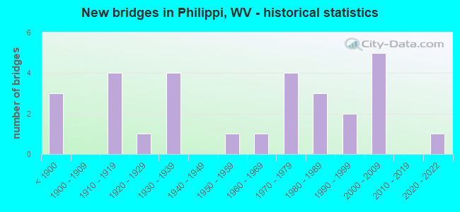
- New bridges - historical statistics
- 3Before 1900
- 41910-1919
- 11920-1929
- 41930-1939
- 11950-1959
- 11960-1969
- 41970-1979
- 31980-1989
- 21990-1999
- 52000-2009
- 12020-2022

- Reconstructed bridges - Historical Statistics
- 11980-1989
- 11990-1999


- Bridge Condition - Deck
- 15.0%Good
- 60.0%Satisfactory
- 20.0%Fair
- 5.0%Poor

- Bridge Condition - Superstructure
- 20.8%Good
- 33.3%Satisfactory
- 29.2%Fair
- 16.7%Poor

- Bridge Condition - Substructure
- 22.7%Good
- 45.5%Satisfactory
- 27.3%Fair
- 4.5%Poor

- Bridge Condition - Channel
- 4.0%Very good
- 56.0%Good
- 32.0%Satisfactory
- 4.0%Fair
- 4.0%Poor

- Bridge Condition - Culverts
- 66.7%Satisfactory
- 33.3%Fair
Find on map >> Show street view
Structure Number: 1A007, Location: 0.01 MI W OF US 119 F (Lat: 39.150481, Lng: -80.053811), Route carried "on" structure: County highway 700, Year Built: 1912, Status: Posted for load, Structure Length: 0.85m (2.79ft), Average Daily Traffic: 850 (year 2018), Truck Traffic: 8%, Average Future Daily Traffic: 1,020 (year 2038), Features Intersected: SHOOKS RUN, Facility Carried by Structure: CO ROUTE 7 SLS
Minimum Vertical Clearance: 30+ m (98+ ft), Kilometerpoint: 18.347, Lanes on structure: 2, Owner: State Highway Agency, Approaching Roadway Width: 6.1m (20.0ft), Material/Design: Concrete, Design/Construction: Arch - Deck, Number Of Spans In Main Unit: 1, Length of Maximum Span: 7.6m (24.9ft), Curb-To-Curb Width: 7.0m (23.0ft), Out-to-Out Width: 7.0m (23.0ft)
Condition: Superstructure: Poor, Channel: Satisfactory, Operating Rating: 31.7 metric tons, Method Used To Determine Operating Rating: Field evaluation and documented engineering judgment, Inventory Rating: 14.5 metric tons, Method Used To Determine Inventory Rating: Field evaluation and documented engineering judgment, Structural Evaluation: Meets minimum limits, Deck Geometry: Meets minimum limits, Waterway Adequacy: Superior to present desirable criteria, Approach Roadway Alignment: Equal to present minimum criteria, Length Of Structure Improvement: 1.22m (4.00ft), Designated Inspection Frequency: Every 24 months, Inspection Date: January 2021, Bridge Improvement Cost: $200,000, Roadway Improvement Cost: $50,000, Total Project Cost: $300,000 ( Estimate for 2021)
Find on map >> Show street view
Structure Number: 1A008, Location: 0.24 MI E CO 40 (Lat: 39.104231, Lng: -79.940339), Route carried "on" structure: County highway 900, Year Built: 1915, Status: Open, Structure Length: 0.89m (2.92ft), Average Daily Traffic: 150 (year 2017), Average Future Daily Traffic: 181 (year 2037), Features Intersected: SUGAR CREEK, Facility Carried by Structure: COUNTY ROUTE 9
Minimum Vertical Clearance: 30+ m (98+ ft), Kilometerpoint: 6.083, Lanes on structure: 1, Owner: State Highway Agency, Approaching Roadway Width: 3.7m (12.1ft), Material/Design: Concrete, Design/Construction: Slab, Number Of Spans In Main Unit: 1, Length of Maximum Span: 8.0m (26.2ft), Curb or Sidewalk Widths: Left: 0.2m (0.7ft), Right: 0.2m (0.7ft), Curb-To-Curb Width: 4.5m (14.8ft), Out-to-Out Width: 5.1m (16.7ft)
Condition: Deck: Good, Superstructure: Good, Substructure: Good, Channel: Good, Operating Rating: 47.2 metric tons, Method Used To Determine Operating Rating: Field evaluation and documented engineering judgment, Inventory Rating: 21.8 metric tons, Method Used To Determine Inventory Rating: Field evaluation and documented engineering judgment, Structural Evaluation: Equal to present minimum criteria, Deck Geometry: High priority of replacement, Waterway Adequacy: Somewhat better than minimum adequacy, Approach Roadway Alignment: Equal to present minimum criteria, Designated Inspection Frequency: Every 24 months, Underwater Inspection Frequency: Every 60 months, Inspection Date: March 2020, Underwater Inspection Date: July 2019, Deck Structure Type: Concrete Cast-file-Place, Wearing Surface/Protective System: Wearing Surface: Gravel
Find on map >> Show street view
Structure Number: 1A037, Location: 0.02 MI E OF CO RT 12 SLS (Lat: 39.183311, Lng: -79.975119), Route carried "on" structure: County highway 2400, Year Built: 1980, Status: Open, Structure Length: 2.56m (8.40ft), Average Daily Traffic: 80 (year 2018), Average Future Daily Traffic: 100 (year 2038), Design Load: HS 20, Features Intersected: LAUREL CREEK, Facility Carried by Structure: CO ROUTE 24 SLS
Minimum Vertical Clearance: 30+ m (98+ ft), Kilometerpoint: 8.063, Lanes on structure: 1, Owner: State Highway Agency, Approaching Roadway Width: 5.5m (18.0ft), Material/Design: Steel, Design/Construction: Stringer/Multi-beam, Number Of Spans In Main Unit: 1, Length of Maximum Span: 24.3m (79.7ft), Curb-To-Curb Width: 4.8m (15.7ft), Out-to-Out Width: 4.9m (16.1ft)
Condition: Deck: Satisfactory, Superstructure: Fair, Substructure: Satisfactory, Channel: Good, Operating Rating: 88.9 metric tons, Method Used To Determine Operating Rating: Load Factor (LF), Inventory Rating: 56.2 metric tons, Method Used To Determine Inventory Rating: Load Factor (LF), Structural Evaluation: Somewhat better than minimum adequacy, Deck Geometry: Equal to present desirable criteria, Waterway Adequacy: Equal to present desirable criteria, Approach Roadway Alignment: Meets minimum limits, Designated Inspection Frequency: Every 24 months, Inspection Date: November 2020, Deck Structure Type: Closed Grating
Find on map >> Show street view
Structure Number: 1A045, Location: 0.04 MI S OF CO 30/2 (Lat: 39.123219, Lng: -80.041669), Route carried "on" structure: County highway 3000, Year Built: 1937, Status: Open, Structure Length: 0.75m (2.46ft), Average Daily Traffic: 1,100 (year 2018), Truck Traffic: 8%, Average Future Daily Traffic: 1,232 (year 2038), Features Intersected: LITTLE LAUREL RUN, Facility Carried by Structure: COUNTY ROUTE 30
Minimum Vertical Clearance: 30+ m (98+ ft), Kilometerpoint: 13.889, Lanes on structure: 2, Owner: State Highway Agency, Approaching Roadway Width: 7.3m (24.0ft), Material/Design: Concrete, Design/Construction: Slab, Number Of Spans In Main Unit: 1, Length of Maximum Span: 7.1m (23.3ft), Curb or Sidewalk Widths: Left: 0.5m (1.6ft), Right: 0.5m (1.6ft), Curb-To-Curb Width: 5.9m (19.4ft), Out-to-Out Width: 6.4m (21.0ft)
Condition: Deck: Satisfactory, Superstructure: Satisfactory, Substructure: Satisfactory, Channel: Good, Operating Rating: 47.2 metric tons, Method Used To Determine Operating Rating: Field evaluation and documented engineering judgment, Inventory Rating: 21.8 metric tons, Method Used To Determine Inventory Rating: Field evaluation and documented engineering judgment, Structural Evaluation: Somewhat better than minimum adequacy, Deck Geometry: High priority of replacement, Waterway Adequacy: Equal to present minimum criteria, Approach Roadway Alignment: Somewhat better than minimum adequacy, Length Of Structure Improvement: 0.76m (2.49ft), Designated Inspection Frequency: Every 24 months, Inspection Date: January 2022, Bridge Improvement Cost: $41,000, Roadway Improvement Cost: $40,000, Total Project Cost: $95,000 ( Estimate for 2022), Deck Structure Type: Concrete Cast-file-Place, Wearing Surface/Protective System: Wearing Surface: Bituminous
Find on map >> Show street view
Structure Number: 1A047, Location: 0.01 MI W OF CO 32/2 (Lat: 39.121489, Lng: -80.095300), Route carried "on" structure: County highway 3200, Year Built: 1987, Status: Open, Structure Length: 1.00m (3.28ft), Average Daily Traffic: 200 (year 2018), Truck Traffic: 8%, Average Future Daily Traffic: 225 (year 2038), Design Load: HS 20+Mod, Features Intersected: ELK CREEK, Facility Carried by Structure: COUNTY ROUTE 32
Minimum Vertical Clearance: 30+ m (98+ ft), Kilometerpoint: 13.003, Lanes on structure: 1, Owner: State Highway Agency, Approaching Roadway Width: 4.9m (16.1ft), Material/Design: Prestressed concrete, Design/Construction: Box Beam or Girders - Multiple, Number Of Spans In Main Unit: 1, Length of Maximum Span: 9.5m (31.2ft), Curb-To-Curb Width: 4.3m (14.1ft), Out-to-Out Width: 4.6m (15.1ft)
Condition: Deck: Fair, Superstructure: Fair, Substructure: Satisfactory, Channel: Satisfactory, Operating Rating: 31.7 metric tons, Method Used To Determine Operating Rating: Load and Resistance Factor (LRFR), Inventory Rating: 24.5 metric tons, Method Used To Determine Inventory Rating: Load and Resistance Factor (LRFR), Structural Evaluation: Somewhat better than minimum adequacy, Deck Geometry: High priority of replacement, Waterway Adequacy: Better than present minimum criteria, Approach Roadway Alignment: Equal to present minimum criteria, Designated Inspection Frequency: Every 24 months, Inspection Date: July 2021, Deck Structure Type: Other, Wearing Surface/Protective System: Wearing Surface: Bituminous, Deck Protection: Epoxy Coated Reinforcing
Find on map >> Show street view
Structure Number: 1A048, Location: 0.01 MI S CO 11/3 (Lat: 39.090189, Lng: -80.086561), Route carried "on" structure: County highway 3600, Year Built: 1856, Year Reconstructed: 2003, Status: Open, Structure Length: 4.64m (15.22ft), Average Daily Traffic: 250 (year 2018), Truck Traffic: 8%, Average Future Daily Traffic: 280 (year 2038), Design Load: HS 20, Features Intersected: BUCKHANNON RIVER, Facility Carried by Structure: COUNTY ROUTE 36
Minimum Vertical Clearance: 3.66m (12.01ft), Kilometerpoint: 7.644, Lanes on structure: 1, Owner: State Highway Agency, Approaching Roadway Width: 5.5m (18.0ft), Material/Design: Prestressed concrete, Design/Construction: Box Beam or Girders - Multiple, Number Of Spans In Main Unit: 1, Number Of Approach Spans: 2, Length of Maximum Span: 14.7m (48.2ft), Curb or Sidewalk Widths: Left: 0.2m (0.7ft), Right: 0.9m (3.0ft), Curb-To-Curb Width: 3.2m (10.5ft), Out-to-Out Width: 3.7m (12.1ft)
Condition: Deck: Satisfactory, Superstructure: Satisfactory, Substructure: Satisfactory, Channel: Satisfactory, Operating Rating: 69.8 metric tons, Method Used To Determine Operating Rating: Load and Resistance Factor (LRFR), Inventory Rating: 53.5 metric tons, Method Used To Determine Inventory Rating: Load and Resistance Factor (LRFR), Structural Evaluation: Equal to present minimum criteria, Deck Geometry: High priority of replacement, Waterway Adequacy: Superior to present desirable criteria, Approach Roadway Alignment: Meets minimum limits, Length Of Structure Improvement: 4.64m (15.22ft), Designated Inspection Frequency: Every 24 months, Underwater Inspection Frequency: Every 60 months, Inspection Date: December 2021, Underwater Inspection Date: July 2019, Bridge Improvement Cost: $1,000,000, Total Project Cost: $1,300,000 ( Estimate for 2022), Deck Structure Type: Other
Find on map >> Show street view
Structure Number: 1A049, Location: 0.08 MI W OF CO 38/9 (Lat: 39.155411, Lng: -79.968019), Route carried "on" structure: State highway 3800, Year Built: 1966, Status: Open, Structure Length: 5.80m (19.03ft), Average Daily Traffic: 1,832 (year 2015), Truck Traffic: 8%, Average Future Daily Traffic: 2,162 (year 2035), Design Load: HS 20, Features Intersected: LAUREL CREEK, Facility Carried by Structure: WV 38
Minimum Vertical Clearance: 30+ m (98+ ft), Kilometerpoint: 4.345, Lanes on structure: 2, Owner: State Highway Agency, Approaching Roadway Width: 13.4m (44.0ft), Skew: 4 degrees, Material/Design: Steel continuous, Design/Construction: Stringer/Multi-beam, Number Of Spans In Main Unit: 1, Number Of Approach Spans: 2, Length of Maximum Span: 21.9m (71.9ft), Curb-To-Curb Width: 8.4m (27.6ft), Out-to-Out Width: 9.1m (29.9ft)
Condition: Deck: Satisfactory, Superstructure: Satisfactory, Substructure: Satisfactory, Channel: Satisfactory, Operating Rating: 68.9 metric tons, Method Used To Determine Operating Rating: Load Factor (LF), Inventory Rating: 41.7 metric tons, Method Used To Determine Inventory Rating: Load Factor (LF), Structural Evaluation: Equal to present minimum criteria, Deck Geometry: Meets minimum limits, Waterway Adequacy: Superior to present desirable criteria, Approach Roadway Alignment: Equal to present desirable criteria, Length Of Structure Improvement: 5.79m (19.00ft), Designated Inspection Frequency: Every 24 months, Inspection Date: July 2020, Bridge Improvement Cost: $200,000, Roadway Improvement Cost: $50,000, Total Project Cost: $300,000 ( Estimate for 2020), Deck Structure Type: Concrete Cast-file-Place, Wearing Surface/Protective System: Wearing Surface: Latex Concrete
Find on map >> Show street view
Structure Number: 1A055, Location: 0.02 MI S OF CO 40/6 (Lat: 39.094050, Lng: -79.935381), Route carried "on" structure: County highway 4000, Year Built: 1989, Status: Open, Structure Length: 2.88m (9.45ft), Average Daily Traffic: 325 (year 2017), Truck Traffic: 8%, Average Future Daily Traffic: 400 (year 2037), Design Load: HS 25 or greater, Features Intersected: SUGAR CREEK, Facility Carried by Structure: COUNTY ROUTE 40
Minimum Vertical Clearance: 30+ m (98+ ft), Kilometerpoint: 8.320, Lanes on structure: 1, Owner: State Highway Agency, Approaching Roadway Width: 6.7m (22.0ft), Material/Design: Prestressed concrete, Design/Construction: Box Beam or Girders - Multiple, Number Of Spans In Main Unit: 1, Length of Maximum Span: 28.3m (92.8ft), Curb-To-Curb Width: 4.5m (14.8ft), Out-to-Out Width: 4.6m (15.1ft)
Condition: Deck: Satisfactory, Superstructure: Satisfactory, Substructure: Satisfactory, Channel: Good, Operating Rating: 78.0 metric tons, Method Used To Determine Operating Rating: Load and Resistance Factor (LRFR), Inventory Rating: 59.9 metric tons, Method Used To Determine Inventory Rating: Load and Resistance Factor (LRFR), Structural Evaluation: Equal to present minimum criteria, Deck Geometry: High priority of replacement, Waterway Adequacy: Equal to present desirable criteria, Approach Roadway Alignment: Equal to present desirable criteria, Length Of Structure Improvement: 2.99m (9.81ft), Designated Inspection Frequency: Every 24 months, Inspection Date: January 2020, Bridge Improvement Cost: $154,000, Roadway Improvement Cost: $89,000, Total Project Cost: $292,000 ( Estimate for 2018), Deck Structure Type: Other, Wearing Surface/Protective System: Wearing Surface: Bituminous, Membrane: Preformed Fabric, Deck Protection: Epoxy Coated Reinforcing
Find on map >> Show street view
Structure Number: 1A065, Location: 0.01 MI W CO 30/7 (Lat: 39.090719, Lng: -80.001539), Route carried "on" structure: County highway 2100, Year Built: 1974, Status: Posted for load, Structure Length: 0.76m (2.49ft), Average Daily Traffic: 498 (year 2015), Truck Traffic: 8%, Average Future Daily Traffic: 599 (year 2035), Design Load: HS 25 or greater, Features Intersected: LAUREL RUN, Facility Carried by Structure: COUNTY ROUTE 21
Minimum Vertical Clearance: 30+ m (98+ ft), Kilometerpoint: 0.901, Lanes on structure: 1, Owner: State Highway Agency, Approaching Roadway Width: 5.5m (18.0ft), Material/Design: Steel, Design/Construction: Stringer/Multi-beam, Number Of Spans In Main Unit: 1, Length of Maximum Span: 6.7m (22.0ft), Curb or Sidewalk Widths: Left: 0.2m (0.7ft), Right: 0.2m (0.7ft), Curb-To-Curb Width: 4.0m (13.1ft), Out-to-Out Width: 4.9m (16.1ft)
Condition: Deck: Poor, Superstructure: Poor, Substructure: Satisfactory, Channel: Satisfactory, Operating Rating: 46.3 metric tons, Method Used To Determine Operating Rating: Load Factor (LF), Inventory Rating: 28.1 metric tons, Method Used To Determine Inventory Rating: Load Factor (LF), Structural Evaluation: Meets minimum limits, Deck Geometry: High priority of replacement, Waterway Adequacy: Equal to present minimum criteria, Approach Roadway Alignment: Equal to present minimum criteria, Bridge Posting: Required (Relationship of Operating Rating to Maximum Legal Load: 10.0 - 19.9% below), Length Of Structure Improvement: 1.37m (4.49ft), Designated Inspection Frequency: Every 24 months, Inspection Date: May 2020, Bridge Improvement Cost: $145,000, Roadway Improvement Cost: $136,000, Total Project Cost: $388,000 ( Estimate for 2020), Deck Structure Type: Wood or Timber, Wearing Surface/Protective System: Wearing Surface: Bituminous
Find on map >> Show street view
Structure Number: 1A07, Location: 0.12 MI N WV 57 (Lat: 39.142061, Lng: -80.112939), Route carried "on" structure: County highway 5710, Year Built: 1914, Status: Posted for load, Structure Length: 1.74m (5.71ft), Average Daily Traffic: 33 (year 2015), Average Future Daily Traffic: 40 (year 2035), Features Intersected: ELK CREEK, Facility Carried by Structure: COUNTY ROUTE 57/10
Minimum Vertical Clearance: 30+ m (98+ ft), Kilometerpoint: 0.193, Lanes on structure: 2, Owner: State Highway Agency, Approaching Roadway Width: 7.3m (24.0ft), Skew: 3 degrees, Material/Design: Concrete, Design/Construction: Arch - Deck, Number Of Spans In Main Unit: 1, Length of Maximum Span: 17.4m (57.1ft), Curb-To-Curb Width: 4.9m (16.1ft), Out-to-Out Width: 4.9m (16.1ft)
Condition: Superstructure: Fair, Channel: Satisfactory, Operating Rating: 28.1 metric tons, Method Used To Determine Operating Rating: Field evaluation and documented engineering judgment, Inventory Rating: 11.8 metric tons, Method Used To Determine Inventory Rating: Field evaluation and documented engineering judgment, Structural Evaluation: Meets minimum limits, Deck Geometry: High priority of corrective action, Waterway Adequacy: Equal to present desirable criteria, Approach Roadway Alignment: Equal to present desirable criteria, Length Of Structure Improvement: 1.83m (6.00ft), Designated Inspection Frequency: Every 24 months, Inspection Date: January 2020, Bridge Improvement Cost: $40,000, Roadway Improvement Cost: $15,000, Total Project Cost: $70,000 ( Estimate for 2020)
Find on map >> Show street view
Structure Number: 1A071, Location: 0.04 MI S WV 57 (Lat: 39.142169, Lng: -80.108361), Route carried "on" structure: County highway 5710, Year Built: 1914, Status: Open, Structure Length: 1.23m (4.04ft), Average Daily Traffic: 30 (year 2015), Average Future Daily Traffic: 40 (year 2035), Features Intersected: ELK CREEK, Facility Carried by Structure: COUNTY ROUTE 57/10
Minimum Vertical Clearance: 30+ m (98+ ft), Kilometerpoint: 0.579, Lanes on structure: 2, Owner: State Highway Agency, Approaching Roadway Width: 7.3m (24.0ft), Material/Design: Concrete, Design/Construction: Arch - Deck, Number Of Spans In Main Unit: 1, Length of Maximum Span: 12.3m (40.4ft), Curb-To-Curb Width: 5.0m (16.4ft), Out-to-Out Width: 5.1m (16.7ft)
Condition: Superstructure: Fair, Substructure: Satisfactory, Channel: Satisfactory, Operating Rating: 47.2 metric tons, Method Used To Determine Operating Rating: Field evaluation and documented engineering judgment, Inventory Rating: 21.8 metric tons, Method Used To Determine Inventory Rating: Field evaluation and documented engineering judgment, Structural Evaluation: Somewhat better than minimum adequacy, Deck Geometry: High priority of corrective action, Waterway Adequacy: Equal to present desirable criteria, Approach Roadway Alignment: Equal to present minimum criteria, Length Of Structure Improvement: 1.52m (4.99ft), Designated Inspection Frequency: Every 24 months, Inspection Date: January 2020, Bridge Improvement Cost: $48,000, Roadway Improvement Cost: $45,000, Total Project Cost: $109,000 ( Estimate for 2020)
Find on map >> Show street view
Structure Number: 1A08, Location: 0.72 MI N CO 40/4 (Lat: 39.129889, Lng: -79.935769), Route carried "on" structure: County highway 9212, Year Built: 1972, Status: Posted for load, Structure Length: 0.80m (2.62ft), Average Daily Traffic: 10 (year 2017), Average Future Daily Traffic: 13 (year 2037), Features Intersected: GLADE CREEK, Facility Carried by Structure: COUNTY ROUTE 92/12
Minimum Vertical Clearance: 30+ m (98+ ft), Kilometerpoint: 1.159, Lanes on structure: 1, Owner: State Highway Agency, Approaching Roadway Width: 3.7m (12.1ft), Material/Design: Steel, Design/Construction: Stringer/Multi-beam, Number Of Spans In Main Unit: 1, Length of Maximum Span: 7.0m (23.0ft), Curb or Sidewalk Widths: Left: 0.2m (0.7ft), Right: 0.2m (0.7ft), Curb-To-Curb Width: 4.3m (14.1ft), Out-to-Out Width: 4.3m (14.1ft)
Condition: Deck: Fair, Superstructure: Satisfactory, Substructure: Fair, Channel: Poor, Operating Rating: 15.4 metric tons, Method Used To Determine Operating Rating: Load Factor (LF), Inventory Rating: 9.1 metric tons, Method Used To Determine Inventory Rating: Load Factor (LF), Structural Evaluation: High priority of replacement, Deck Geometry: Equal to present minimum criteria, Waterway Adequacy: Somewhat better than minimum adequacy, Approach Roadway Alignment: Equal to present minimum criteria, Bridge Posting: Required (Relationship of Operating Rating to Maximum Legal Load: 30.0 - 39.9% below), Length Of Structure Improvement: 0.79m (2.59ft), Designated Inspection Frequency: Every 24 months, Inspection Date: March 2020, Bridge Improvement Cost: $29,000, Roadway Improvement Cost: $28,000, Total Project Cost: $80,000 ( Estimate for 2020), Deck Structure Type: Wood or Timber
Find on map >> Show street view
Structure Number: 1A085, Location: 0.13 MI N JCT CO 22 SLS (Lat: 39.178019, Lng: -80.055611), Route carried "on" structure: US 11900, Year Built: 1925, Status: Open, Structure Length: 1.01m (3.31ft), Average Daily Traffic: 3,100 (year 2018), Truck Traffic: 9%, Average Future Daily Traffic: 3,658 (year 2038), Features Intersected: HACKERS CREEK, Facility Carried by Structure: US 119 T
Minimum Vertical Clearance: 30+ m (98+ ft), Kilometerpoint: 21.887, Lanes on structure: 2, Base Highway Network: Yes, Owner: State Highway Agency, Approaching Roadway Width: 8.5m (27.9ft), Skew: 3 degrees, Material/Design: Concrete, Design/Construction: Slab, Number Of Spans In Main Unit: 1, Length of Maximum Span: 9.0m (29.5ft), Curb-To-Curb Width: 7.3m (24.0ft), Out-to-Out Width: 8.4m (27.6ft)
Condition: Deck: Fair, Superstructure: Fair, Substructure: Fair, Channel: Satisfactory, Operating Rating: 63.5 metric tons, Method Used To Determine Operating Rating: Field evaluation and documented engineering judgment, Inventory Rating: 29.0 metric tons, Method Used To Determine Inventory Rating: Field evaluation and documented engineering judgment, Structural Evaluation: Somewhat better than minimum adequacy, Deck Geometry: High priority of replacement, Waterway Adequacy: Superior to present desirable criteria, Approach Roadway Alignment: Equal to present desirable criteria, Length Of Structure Improvement: 1.52m (4.99ft), Designated Inspection Frequency: Every 24 months, Inspection Date: Febuary 2021, Bridge Improvement Cost: $275,000, Roadway Improvement Cost: $75,000, Total Project Cost: $450,000 ( Estimate for 2021), Deck Structure Type: Concrete Cast-file-Place, Wearing Surface/Protective System: Wearing Surface: Bituminous
Find on map >> Show street view
Structure Number: 1A086, Location: 0.12 MI S OF CO 6 (Lat: 39.208969, Lng: -80.053961), Route carried "on" structure: US 11900, Year Built: 1994, Status: Open, Structure Length: 10.67m (35.01ft), Average Daily Traffic: 2,184 (year 2015), Truck Traffic: 9%, Average Future Daily Traffic: 2,562 (year 2035), Design Load: HS 25 or greater, Features Intersected: CSX RAILROAD, Facility Carried by Structure: US 119
Minimum Vertical Clearance: 30+ m (98+ ft), Kilometerpoint: 25.524, Lanes on structure: 2, Base Highway Network: Yes, Owner: State Highway Agency, Approaching Roadway Width: 9.1m (29.9ft), Skew: 9 degrees, Material/Design: Steel continuous, Design/Construction: Stringer/Multi-beam, Number Of Spans In Main Unit: 1, Number Of Approach Spans: 3, Length of Maximum Span: 28.0m (91.9ft), Curb or Sidewalk Widths: Left: 0.2m (0.7ft), Right: 0.2m (0.7ft), Curb-To-Curb Width: 9.1m (29.9ft), Out-to-Out Width: 10.2m (33.5ft)
Condition: Deck: Satisfactory, Superstructure: Good, Substructure: Good, Operating Rating: 52.6 metric tons, Method Used To Determine Operating Rating: Load and Resistance Factor (LRFR), Inventory Rating: 40.8 metric tons, Method Used To Determine Inventory Rating: Load and Resistance Factor (LRFR), Structural Evaluation: Better than present minimum criteria, Deck Geometry: Meets minimum limits, Underclear: Better than present minimum criteria, Approach Roadway Alignment: Equal to present desirable criteria, Designated Inspection Frequency: Every 48 months, Inspection Date: May 2019, Deck Structure Type: Concrete Cast-file-Place, Wearing Surface/Protective System: Wearing Surface: Monolithic Concrete, Deck Protection: Epoxy Coated Reinforcing
Find on map >> Show street view
Structure Number: 1A087, Location: 1.01 MI S CO 10 (Lat: 39.229950, Lng: -80.054589), Route carried "on" structure: US 11900, Year Built: 1937, Status: Open, Structure Length: 6.49m (21.29ft), Average Daily Traffic: 2,184 (year 2017), Truck Traffic: 9%, Average Future Daily Traffic: 2,578 (year 2037), Features Intersected: A&O RAILROAD, Facility Carried by Structure: US 119
Minimum Vertical Clearance: 30+ m (98+ ft), Kilometerpoint: 28.147, Lanes on structure: 2, Base Highway Network: Yes, Owner: State Highway Agency, Approaching Roadway Width: 9.1m (29.9ft), Skew: 6 degrees, Material/Design: Steel, Design/Construction: Stringer/Multi-beam, Number Of Spans In Main Unit: 1, Number Of Approach Spans: 2, Length of Maximum Span: 18.9m (62.0ft), Curb-To-Curb Width: 9.0m (29.5ft), Out-to-Out Width: 10.2m (33.5ft)
Condition: Deck: Fair, Superstructure: Poor, Substructure: Poor, Operating Rating: 49.0 metric tons, Method Used To Determine Operating Rating: Load Factor (LF), Inventory Rating: 29.0 metric tons, Method Used To Determine Inventory Rating: Load Factor (LF), Structural Evaluation: Meets minimum limits, Deck Geometry: Meets minimum limits, Underclear: Better than present minimum criteria, Approach Roadway Alignment: Equal to present minimum criteria, Length Of Structure Improvement: 7.62m (25.00ft), Designated Inspection Frequency: Every 24 months, Inspection Date: March 2020, Bridge Improvement Cost: $850,000, Roadway Improvement Cost: $450,000, Total Project Cost: $1,500,000 ( Estimate for 2020), Deck Structure Type: Concrete Cast-file-Place, Wearing Surface/Protective System: Wearing Surface: Latex Concrete, Deck Protection: Epoxy Coated Reinforcing
Find on map >> Show street view
Structure Number: 1A092, Location: 0.07 MI. S. OF US 119 (Lat: 39.152989, Lng: -80.043331), Route carried "on" structure: US 25000, Year Built: 1852, Year Reconstructed: 1991, Status: Posted for load, Structure Length: 9.50m (31.17ft), Average Daily Traffic: 7,000 (year 2018), Truck Traffic: 9%, Average Future Daily Traffic: 8,260 (year 2038), Design Load: H 15, Features Intersected: TYGART VALLEY RIVER, Facility Carried by Structure: US 250 (T)
Minimum Vertical Clearance: 3.18m (10.43ft), Kilometerpoint: 27.745, Lanes on structure: 2, Base Highway Network: Yes, Owner: State Highway Agency, Approaching Roadway Width: 9.4m (30.8ft), Skew: 10 degrees, Material/Design: Steel continuous, Design/Construction: Stringer/Multi-beam, Number Of Spans In Main Unit: 2, Number Of Approach Spans: 4, Length of Maximum Span: 23.8m (78.1ft), Curb or Sidewalk Widths: Left: 1.2m (3.9ft), Right: 0.0m, Curb-To-Curb Width: 6.1m (20.0ft), Out-to-Out Width: 6.2m (20.3ft)
Condition: Deck: Satisfactory, Superstructure: Satisfactory, Substructure: Fair, Channel: Good, Operating Rating: 49.0 metric tons, Method Used To Determine Operating Rating: Load Factor (LF), Inventory Rating: 29.0 metric tons, Method Used To Determine Inventory Rating: Load Factor (LF), Structural Evaluation: Somewhat better than minimum adequacy, Deck Geometry: High priority of replacement, Waterway Adequacy: Equal to present desirable criteria, Approach Roadway Alignment: Somewhat better than minimum adequacy, Bridge Posting: Required (Relationship of Operating Rating to Maximum Legal Load: 10.0 - 19.9% below), Length Of Structure Improvement: 10.06m (33.01ft), Designated Inspection Frequency: Every 24 months, Critical Feature Inspection Frequency: Every 24 months, Underwater Inspection Frequency: Every 60 months, Inspection Date: August 2020, Critical Feature Inspection Date: August 2018, Underwater Inspection Date: July 2017, Bridge Improvement Cost: $5,000,000, Roadway Improvement Cost: $1,000,000, Total Project Cost: $7,500,000 ( Estimate for 2021), Deck Structure Type: Concrete Cast-file-Place, Wearing Surface/Protective System: Deck Protection: Epoxy Coated Reinforcing
Find on map >> Show street view
Structure Number: 1A093, Location: 0.08 MI E OF CO 119/5 (Lat: 39.155719, Lng: -80.043019), Route carried "on" structure: County highway 11921, Year Built: 1972, Status: Open, Structure Length: 10.33m (33.89ft), Average Daily Traffic: 4,101 (year 2015), Truck Traffic: 8%, Average Future Daily Traffic: 431 (year 2035), Design Load: HS 15, Features Intersected: TYGART VALLEY RIVER, Facility Carried by Structure: COUNTY RT 119/21
Minimum Vertical Clearance: 30+ m (98+ ft), Kilometerpoint: 0.129, Lanes on structure: 2, Owner: State Highway Agency, Approaching Roadway Width: 6.1m (20.0ft), Material/Design: Steel continuous, Design/Construction: Stringer/Multi-beam, Number Of Spans In Main Unit: 1, Number Of Approach Spans: 2, Length of Maximum Span: 37.5m (123.0ft), Curb or Sidewalk Widths: Left: 0.0m, Right: 1.1m (3.6ft), Curb-To-Curb Width: 6.2m (20.3ft), Out-to-Out Width: 6.9m (22.6ft)
Condition: Deck: Satisfactory, Superstructure: Satisfactory, Substructure: Fair, Channel: Good, Operating Rating: 45.4 metric tons, Method Used To Determine Operating Rating: Load Factor (LF), Inventory Rating: 27.2 metric tons, Method Used To Determine Inventory Rating: Load Factor (LF), Structural Evaluation: Somewhat better than minimum adequacy, Deck Geometry: High priority of replacement, Waterway Adequacy: Equal to present desirable criteria, Approach Roadway Alignment: Equal to present desirable criteria, Length Of Structure Improvement: 11.37m (37.30ft), Designated Inspection Frequency: Every 24 months, Underwater Inspection Frequency: Every 12 months, Inspection Date: August 2020, Underwater Inspection Date: July 2021, Bridge Improvement Cost: $1,283,000, Roadway Improvement Cost: $1,103,000, Total Project Cost: $2,966,000 ( Estimate for 2019), Deck Structure Type: Concrete Cast-file-Place, Wearing Surface/Protective System: Wearing Surface: Latex Concrete
Find on map >> Show street view
Structure Number: 1A097, Location: 0.01 MI N OF US 250 (Lat: 39.151700, Lng: -80.045019), Route carried "on" structure: US 11900, Year Built: 1995, Status: Open, Structure Length: 0.71m (2.33ft), Average Daily Traffic: 5,100 (year 2018), Truck Traffic: 7%, Average Future Daily Traffic: 5,661 (year 2038), Design Load: HS 25 or greater, Features Intersected: SHOOKS RUN, Facility Carried by Structure: US 119
Minimum Vertical Clearance: 30+ m (98+ ft), Kilometerpoint: 18.347, Lanes on structure: 3, Base Highway Network: Yes, Owner: State Highway Agency, Approaching Roadway Width: 8.5m (27.9ft), Skew: 3 degrees, Material/Design: Aluminum, Iron, Design/Construction: Culvert, Number Of Spans In Main Unit: 1, Length of Maximum Span: 6.9m (22.6ft), Curb or Sidewalk Widths: Left: 1.5m (4.9ft), Right: 1.5m (4.9ft)
Condition: Channel: Good, Culverts: Satisfactory, Operating Rating: 88.9 metric tons, Method Used To Determine Operating Rating: Field evaluation and documented engineering judgment, Inventory Rating: 40.8 metric tons, Method Used To Determine Inventory Rating: Field evaluation and documented engineering judgment, Structural Evaluation: Equal to present minimum criteria, Waterway Adequacy: Equal to present minimum criteria, Approach Roadway Alignment: Equal to present desirable criteria, Designated Inspection Frequency: Every 48 months, Inspection Date: October 2021
Find on map >> Show street view
Structure Number: 1A098, Location: 0.01 MI W OF CO 57/10 SLS (Lat: 39.142419, Lng: -80.108061), Route carried "on" structure: State highway 5700, Year Built: 1950, Status: Open, Structure Length: 0.94m (3.08ft), Average Daily Traffic: 3,200 (year 2018), Truck Traffic: 9%, Average Future Daily Traffic: 3,750 (year 2038), Features Intersected: SPAW LICK, Facility Carried by Structure: WV ROUTE 57 F
Minimum Vertical Clearance: 30+ m (98+ ft), Kilometerpoint: 11.668, Lanes on structure: 2, Owner: State Highway Agency, Approaching Roadway Width: 10.7m (35.1ft), Skew: 4 degrees, Material/Design: Concrete, Design/Construction: Culvert, Number Of Spans In Main Unit: 2, Length of Maximum Span: 4.3m (14.1ft)
Condition: Channel: Good, Culverts: Fair, Operating Rating: 53.5 metric tons, Method Used To Determine Operating Rating: Field evaluation and documented engineering judgment, Inventory Rating: 24.5 metric tons, Method Used To Determine Inventory Rating: Field evaluation and documented engineering judgment, Structural Evaluation: Somewhat better than minimum adequacy, Waterway Adequacy: Superior to present desirable criteria, Approach Roadway Alignment: Equal to present desirable criteria, Length Of Structure Improvement: 1.22m (4.00ft), Designated Inspection Frequency: Every 24 months, Inspection Date: October 2020, Bridge Improvement Cost: $200,000, Roadway Improvement Cost: $50,000, Total Project Cost: $400,000 ( Estimate for 2020)
Find on map >> Show street view
Structure Number: 1A106, Location: .04 MI N CO 7/7 (Lat: 39.150250, Lng: -80.060089), Route carried "on" structure: County highway 710, Year Built: 1930, Status: Posted for load, Structure Length: 1.25m (4.10ft), Average Daily Traffic: 30 (year 2018), Average Future Daily Traffic: 45 (year 2038), Features Intersected: SHOOKS RUN, Facility Carried by Structure: COUNTY ROUTE 7/10
Minimum Vertical Clearance: 30+ m (98+ ft), Kilometerpoint: 0.145, Lanes on structure: 2, Owner: State Highway Agency, Approaching Roadway Width: 6.1m (20.0ft), Material/Design: Steel, Design/Construction: Stringer/Multi-beam, Number Of Spans In Main Unit: 1, Length of Maximum Span: 11.4m (37.4ft), Curb or Sidewalk Widths: Left: 0.2m (0.7ft), Right: 0.2m (0.7ft), Curb-To-Curb Width: 5.8m (19.0ft), Out-to-Out Width: 6.1m (20.0ft)
Condition: Deck: Satisfactory, Superstructure: Fair, Substructure: Fair, Channel: Good, Operating Rating: 31.7 metric tons, Method Used To Determine Operating Rating: Load Factor (LF), Inventory Rating: 19.0 metric tons, Method Used To Determine Inventory Rating: Load Factor (LF), Structural Evaluation: Somewhat better than minimum adequacy, Deck Geometry: Meets minimum limits, Waterway Adequacy: Superior to present desirable criteria, Approach Roadway Alignment: Equal to present desirable criteria, Bridge Posting: Required (Relationship of Operating Rating to Maximum Legal Load: 20.0 - 29.9% below), Length Of Structure Improvement: 1.34m (4.40ft), Designated Inspection Frequency: Every 24 months, Inspection Date: August 2021, Bridge Improvement Cost: $40,000, Roadway Improvement Cost: $39,000, Total Project Cost: $96,000 ( Estimate for 2021), Deck Structure Type: Concrete Cast-file-Place, Wearing Surface/Protective System: Wearing Surface: Bituminous
Find on map >> Show street view
Structure Number: 1A107, Location: 0.08 MI N CO 30 (Lat: 39.148861, Lng: -80.040039), Route carried "on" structure: US 25000, Year Built: 2001, Status: Open, Structure Length: 27.39m (89.86ft), Average Daily Traffic: 7,925 (year 2017), Truck Traffic: 9%, Average Future Daily Traffic: 9,275 (year 2037), Design Load: HL 93, Features Intersected: TYGART VALLEY RV CSX RR, Facility Carried by Structure: US 250 T
Minimum Vertical Clearance: 30+ m (98+ ft), Kilometerpoint: 27.182, Lanes on structure: 2, Base Highway Network: Yes, Owner: State Highway Agency, Approaching Roadway Width: 12.2m (40.0ft), Material/Design: Prestressed concrete continuous, Design/Construction: Stringer/Multi-beam, Number Of Spans In Main Unit: 3, Number Of Approach Spans: 4, Length of Maximum Span: 42.7m (140.1ft), Curb-To-Curb Width: 13.4m (44.0ft), Out-to-Out Width: 14.2m (46.6ft)
Condition: Deck: Good, Superstructure: Fair, Substructure: Satisfactory, Channel: Good, Operating Rating: 38.1 metric tons, Method Used To Determine Operating Rating: Load and Resistance Factor (LRFR), Inventory Rating: 29.9 metric tons, Method Used To Determine Inventory Rating: Load and Resistance Factor (LRFR), Structural Evaluation: Somewhat better than minimum adequacy, Deck Geometry: Equal to present minimum criteria, Underclear: Superior to present desirable criteria, Waterway Adequacy: Superior to present desirable criteria, Approach Roadway Alignment: Equal to present desirable criteria, Designated Inspection Frequency: Every 24 months, Underwater Inspection Frequency: Every 60 months, Inspection Date: March 2020, Underwater Inspection Date: July 2017, Deck Structure Type: Concrete Cast-file-Place, Wearing Surface/Protective System: Wearing Surface: Latex Concrete, Deck Protection: Epoxy Coated Reinforcing
Find on map >> Show street view
Structure Number: 1A108, Location: 0.01 MI S OF CO 5/8 (Lat: 39.144689, Lng: -79.960181), Route carried "on" structure: County highway 4001, Year Built: 2002, Status: Open, Structure Length: 2.91m (9.55ft), Average Daily Traffic: 33 (year 2018), Average Future Daily Traffic: 40 (year 2038), Design Load: HS 25 or greater, Features Intersected: SUGAR CREEK, Facility Carried by Structure: COUNTY ROUTE 40/1
Minimum Vertical Clearance: 30+ m (98+ ft), Kilometerpoint: 1.996, Lanes on structure: 2, Owner: State Highway Agency, Approaching Roadway Width: 6.7m (22.0ft), Material/Design: Prestressed concrete, Design/Construction: Box Beam or Girders - Multiple, Number Of Spans In Main Unit: 1, Length of Maximum Span: 28.7m (94.2ft), Curb-To-Curb Width: 7.3m (24.0ft), Out-to-Out Width: 7.5m (24.6ft)
Condition: Deck: Satisfactory, Superstructure: Satisfactory, Substructure: Good, Channel: Good, Operating Rating: 70.7 metric tons, Method Used To Determine Operating Rating: Load and Resistance Factor (LRFR), Inventory Rating: 54.4 metric tons, Method Used To Determine Inventory Rating: Load and Resistance Factor (LRFR), Structural Evaluation: Equal to present minimum criteria, Deck Geometry: Equal to present minimum criteria, Waterway Adequacy: Equal to present desirable criteria, Approach Roadway Alignment: Equal to present desirable criteria, Designated Inspection Frequency: Every 48 months, Inspection Date: September 2020, Deck Structure Type: Other, Wearing Surface/Protective System: Wearing Surface: Bituminous, Deck Protection: Epoxy Coated Reinforcing
Find on map >> Show street view
Structure Number: 1A111, Location: 0.01 MI E OF CO 38/13 (Lat: 39.130869, Lng: -79.958519), Route carried "on" structure: County highway 4004, Year Built: 2003, Status: Open, Structure Length: 2.91m (9.55ft), Average Daily Traffic: 30 (year 2015), Average Future Daily Traffic: 40 (year 2035), Design Load: HS 25 or greater, Features Intersected: SUGAR CREEK, Facility Carried by Structure: COUNTY ROUTE 40/4
Minimum Vertical Clearance: 30+ m (98+ ft), Kilometerpoint: 0.016, Lanes on structure: 2, Owner: State Highway Agency, Approaching Roadway Width: 4.9m (16.1ft), Skew: 3 degrees, Material/Design: Prestressed concrete, Design/Construction: Box Beam or Girders - Multiple, Number Of Spans In Main Unit: 1, Length of Maximum Span: 28.7m (94.2ft), Curb-To-Curb Width: 7.3m (24.0ft), Out-to-Out Width: 7.5m (24.6ft)
Condition: Superstructure: Good, Substructure: Good, Channel: Very good, Operating Rating: 69.8 metric tons, Method Used To Determine Operating Rating: Load Factor (LF), Inventory Rating: 53.5 metric tons, Method Used To Determine Inventory Rating: Load Factor (LF), Structural Evaluation: Better than present minimum criteria, Deck Geometry: Equal to present minimum criteria, Waterway Adequacy: Superior to present desirable criteria, Approach Roadway Alignment: Equal to present minimum criteria, Designated Inspection Frequency: Every 48 months, Inspection Date: April 2018, Deck Structure Type: Other, Wearing Surface/Protective System: Wearing Surface: Bituminous, Deck Protection: Epoxy Coated Reinforcing
Find on map >> Show street view
Structure Number: 1A112, Location: 0.01 MI S. US 250 TRUCK (Lat: 39.146189, Lng: -80.039219), Route carried "on" structure: County highway 3000, Year Built: 2001, Status: Open, Structure Length: 0.69m (2.26ft), Average Daily Traffic: 875 (year 2015), Truck Traffic: 4%, Average Future Daily Traffic: 1,050 (year 2035), Design Load: HS 25 or greater, Features Intersected: Anglins Run, Facility Carried by Structure: CO 30 SLS
Minimum Vertical Clearance: 30+ m (98+ ft), Kilometerpoint: 17.413, Lanes on structure: 2, Owner: State Highway Agency, Approaching Roadway Width: 7.3m (24.0ft), Material/Design: Concrete continuous, Design/Construction: Culvert, Number Of Spans In Main Unit: 2, Length of Maximum Span: 3.0m (9.8ft), Curb or Sidewalk Widths: Left: 1.2m (3.9ft), Right: 0.0m
Condition: Channel: Fair, Culverts: Satisfactory, Operating Rating: 88.9 metric tons, Method Used To Determine Operating Rating: Field evaluation and documented engineering judgment, Inventory Rating: 40.8 metric tons, Method Used To Determine Inventory Rating: Field evaluation and documented engineering judgment, Structural Evaluation: Equal to present minimum criteria, Waterway Adequacy: Equal to present desirable criteria, Approach Roadway Alignment: Equal to present desirable criteria, Designated Inspection Frequency: Every 48 months, Inspection Date: May 2018
Find on map >> Show street view
Structure Number: 1A114, Location: 0.08 MI S US 119 (Lat: 39.179581, Lng: -80.052750), Route carried "on" structure: County highway 11902, Year Built: 2005, Status: Open, Structure Length: 1.00m (3.28ft), Average Daily Traffic: 20 (year 2018), Truck Traffic: 8%, Average Future Daily Traffic: 22 (year 2038), Design Load: HS 25 or greater, Features Intersected: HACKERS CREEK, Facility Carried by Structure: COUNTY ROUTE 119/2
Minimum Vertical Clearance: 30+ m (98+ ft), Kilometerpoint: 0.225, Lanes on structure: 1, Owner: State Highway Agency, Approaching Roadway Width: 4.9m (16.1ft), Material/Design: Steel, Design/Construction: Stringer/Multi-beam, Number Of Spans In Main Unit: 1, Length of Maximum Span: 9.4m (30.8ft), Curb-To-Curb Width: 4.6m (15.1ft), Out-to-Out Width: 4.6m (15.1ft)
Condition: Deck: Satisfactory, Superstructure: Good, Substructure: Fair, Channel: Good, Operating Rating: 80.7 metric tons, Method Used To Determine Operating Rating: Load Factor (LF), Inventory Rating: 49.0 metric tons, Method Used To Determine Inventory Rating: Load Factor (LF), Structural Evaluation: Somewhat better than minimum adequacy, Deck Geometry: Better than present minimum criteria, Waterway Adequacy: Better than present minimum criteria, Approach Roadway Alignment: Equal to present minimum criteria, Designated Inspection Frequency: Every 24 months, Inspection Date: November 2021, Deck Structure Type: Wood or Timber, Wearing Surface/Protective System: Wearing Surface: Bituminous
Find on map >> Show street view
Structure Number: 1A115, Location: 0.01 MI S OF WV 57 (Lat: 39.138181, Lng: -80.103919), Route carried "on" structure: County highway 5715, Year Built: 1886, Status: Posted for load, Structure Length: 2.94m (9.65ft), Average Daily Traffic: 11 (year 2015), Average Future Daily Traffic: 13 (year 2035), Features Intersected: ELK CREEK, Facility Carried by Structure: COUNTY ROUTE 57/15
Minimum Vertical Clearance: 4.06m (13.32ft), Kilometerpoint: 0.016, Lanes on structure: 1, Owner: State Highway Agency, Approaching Roadway Width: 3.7m (12.1ft), Material/Design: Steel, Design/Construction: Truss - Thru, Number Of Spans In Main Unit: 1, Length of Maximum Span: 28.5m (93.5ft), Curb or Sidewalk Widths: Left: 0.2m (0.7ft), Right: 0.2m (0.7ft), Curb-To-Curb Width: 3.7m (12.1ft), Out-to-Out Width: 3.7m (12.1ft)
Condition: Deck: Satisfactory, Superstructure: Poor, Substructure: Satisfactory, Channel: Good, Operating Rating: 10.9 metric tons, Method Used To Determine Operating Rating: Load Factor (LF), Inventory Rating: 6.3 metric tons, Method Used To Determine Inventory Rating: Load Factor (LF), Structural Evaluation: High priority of replacement, Deck Geometry: High priority of replacement, Waterway Adequacy: Superior to present desirable criteria, Approach Roadway Alignment: Meets minimum limits, Bridge Posting: Required (Relationship of Operating Rating to Maximum Legal Load: > 39.9% below), Length Of Structure Improvement: 3.78m (12.40ft), Designated Inspection Frequency: Every 24 months, Critical Feature Inspection Frequency: Every 24 months, Inspection Date: March 2020, Critical Feature Inspection Date: March 2020, Bridge Improvement Cost: $463,000, Roadway Improvement Cost: $235,000, Total Project Cost: $821,000 ( Estimate for 2020), Deck Structure Type: Wood or Timber
Find on map >> Show street view
Structure Number: 1A124, Location: 0.02 MI E CO 250/5 (Lat: 39.117719, Lng: -79.960119), Route carried "on" structure: County highway 405, Year Built: 2020, Status: Open, Structure Length: 2.14m (7.02ft), Average Daily Traffic: 300 (year 2018), Truck Traffic: 8%, Average Future Daily Traffic: 354 (year 2038), Design Load: HL 93, Features Intersected: SUGAR CREEK, Facility Carried by Structure: COUNTY ROUTE 40/5
Minimum Vertical Clearance: 30+ m (98+ ft), Kilometerpoint: 0.032, Lanes on structure: 2, Owner: State Highway Agency, Approaching Roadway Width: 8.2m (26.9ft), Skew: 1 degrees, Material/Design: Prestressed concrete, Design/Construction: Box Beam or Girders - Multiple, Number Of Spans In Main Unit: 1, Length of Maximum Span: 21.3m (69.9ft), Curb-To-Curb Width: 8.2m (26.9ft), Out-to-Out Width: 8.4m (27.6ft)
Condition: Deck: Good, Superstructure: Good, Substructure: Good, Channel: Good, Operating Rating: 60.8 metric tons, Method Used To Determine Operating Rating: Load and Resistance Factor (LRFR), Inventory Rating: 46.3 metric tons, Method Used To Determine Inventory Rating: Load and Resistance Factor (LRFR), Structural Evaluation: Better than present minimum criteria, Deck Geometry: Somewhat better than minimum adequacy, Waterway Adequacy: Equal to present desirable criteria, Approach Roadway Alignment: Somewhat better than minimum adequacy, Designated Inspection Frequency: Every 24 months, Inspection Date: January 2021, Deck Structure Type: Concrete Precast Panels, Wearing Surface/Protective System: Wearing Surface: Bituminous, Membrane: Other, Deck Protection: Epoxy Coated Reinforcing
Find on map >> Show street view
Structure Number: 1A035, Location: 0.04 MI W OF CO 22/3 (Lat: 39.190169, Lng: -80.030811), Route carried "under" structure: County highway 2200, Year Built: 1936, Structure Length: 0. m, Average Daily Traffic: 50 (year 2018), Features Intersected: CSX RAILROAD, Facility Carried by Structure: CSX RR
Minimum Vertical Clearance: 6.30m (20.67ft), Kilometerpoint: 7.226, Lanes under structure: 1, Material/Design: Concrete, Design/Construction: Slab, Length of Maximum Span: 9.2m (30.2ft)
Find on map >> Show street view
Structure Number: 1A094, Location: 0.35 MI W US 119 (Lat: 39.195839, Lng: -80.058650), Route carried "under" structure: State highway 7600, Year Built: 1975, Structure Length: 0. m, Average Daily Traffic: 963 (year 2015), Truck Traffic: 10%, Features Intersected: CONVEYOR BELT, Facility Carried by Structure: SENTINEL MINE CONV
Minimum Vertical Clearance: 9.68m (31.76ft), Kilometerpoint: 10.091, Lanes under structure: 2, Length of Maximum Span: 44.2m (145.0ft)