Bridge Statistics for Peyton, Colorado (CO)
Condition, Traffic, Stress, Structural Evaluation, Project Costs
- National Bridge Inventory (NBI) Statistics
- 13Number of bridges
- 112ft / 34.2mTotal length
- $615,000Total costs
- 53,665Total average daily traffic
- 3,691Total average daily truck traffic
- 70,221Total future (year 2040) average daily traffic
- National Bridge Inventory (NBI) Registered Bridges for Peyton
- No street view available for this location
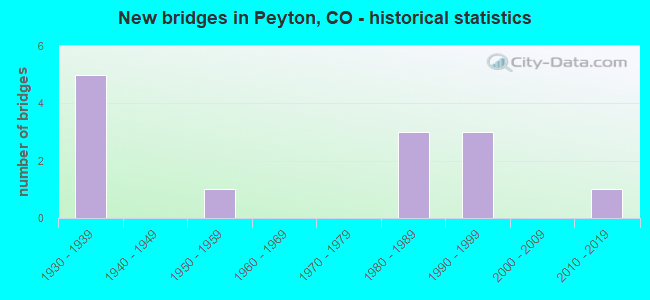
- New bridges - historical statistics
- 51930-1939
- 11950-1959
- 31980-1989
- 31990-1999
- 12010-2019


- Bridge Condition - Deck
- 16.7%Very good
- 16.7%Good
- 58.3%Satisfactory
- 8.3%Poor

- Bridge Condition - Superstructure
- 8.3%Very good
- 25.0%Good
- 16.7%Satisfactory
- 50.0%Fair

- Bridge Condition - Substructure
- 16.7%Good
- 58.3%Satisfactory
- 25.0%Fair

- Bridge Condition - Channel
- 53.8%Very good
- 30.8%Good
- 15.4%Satisfactory
Find on map >> Show street view
Structure Number: EPC0044-07.68A, Location: 0.7 MI E OF PEYTON HWY (Lat: 39.042244, Lng: -104.467964), Route carried "on" structure: County highway , Year Built: 1989, Status: Open, Structure Length: 1.25m (4.10ft), Average Daily Traffic: 777 (year 2020), Truck Traffic: 4%, Average Future Daily Traffic: 1,018 (year 2040), Design Load: HS 20, Features Intersected: BRANCH SPRING CREEK, Facility Carried by Structure: MURPHY ROAD
Minimum Vertical Clearance: 30+ m (98+ ft), Kilometerpoint: 12.189, Lanes on structure: 2, Owner: County Highway Agency, Approaching Roadway Width: 7.0m (23.0ft), Material/Design: Steel, Design/Construction: Stringer/Multi-beam, Number Of Spans In Main Unit: 1, Length of Maximum Span: 11.7m (38.4ft), Curb-To-Curb Width: 11.0m (36.1ft), Out-to-Out Width: 11.0m (36.1ft)
Condition: Deck: Satisfactory, Superstructure: Satisfactory, Substructure: Satisfactory, Channel: Very good, Operating Rating: 45.4 metric tons, Method Used To Determine Operating Rating: Load Factor (LF), Inventory Rating: 27.2 metric tons, Method Used To Determine Inventory Rating: Load Factor (LF), Structural Evaluation: Equal to present minimum criteria, Deck Geometry: Better than present minimum criteria, Waterway Adequacy: Equal to present desirable criteria, Approach Roadway Alignment: Equal to present desirable criteria, Designated Inspection Frequency: Every 24 months, Inspection Date: January 2022, Deck Structure Type: Corrugated Steel, Wearing Surface/Protective System: Wearing Surface: Bituminous
Find on map >> Show street view
Structure Number: EPC0091-01.5, Location: 1.7 MI N JUDGE ORR ROAD (Lat: 38.975556, Lng: -104.534167), Route carried "on" structure: County highway , Year Built: 1934, Status: Open, Structure Length: 1.22m (4.00ft), Average Daily Traffic: 1,273 (year 2020), Truck Traffic: 9%, Average Future Daily Traffic: 1,668 (year 2040), Features Intersected: BLACK SQUIRREL CREEK, Facility Carried by Structure: ELBERT ROAD
Minimum Vertical Clearance: 30+ m (98+ ft), Kilometerpoint: 2.475, Lanes on structure: 2, Owner: County Highway Agency, Approaching Roadway Width: 7.6m (24.9ft), Skew: 3 degrees, Material/Design: Steel continuous, Design/Construction: Stringer/Multi-beam, Number Of Spans In Main Unit: 2, Length of Maximum Span: 5.9m (19.4ft), Curb-To-Curb Width: 8.9m (29.2ft), Out-to-Out Width: 9.1m (29.9ft)
Condition: Deck: Very good, Superstructure: Fair, Substructure: Satisfactory, Channel: Good, Operating Rating: 92.7 metric tons, Method Used To Determine Operating Rating: Load Factor (LF), Inventory Rating: 55.6 metric tons, Method Used To Determine Inventory Rating: Load Factor (LF), Structural Evaluation: Somewhat better than minimum adequacy, Deck Geometry: Somewhat better than minimum adequacy, Waterway Adequacy: Equal to present desirable criteria, Approach Roadway Alignment: Equal to present desirable criteria, Designated Inspection Frequency: Every 24 months, Inspection Date: Febuary 2022, Deck Structure Type: Corrugated Steel, Wearing Surface/Protective System: Wearing Surface: Bituminous
Find on map >> Show street view
Structure Number: EPC0091-04.37A, Location: 0.4 MI N OF LATIGO BLVD (Lat: 39.018114, Lng: -104.534278), Route carried "on" structure: County highway , Year Built: 1996, Status: Open, Structure Length: 3.66m (12.01ft), Average Daily Traffic: 2,050 (year 2020), Truck Traffic: 5%, Average Future Daily Traffic: 2,685 (year 2040), Design Load: HS 20, Features Intersected: BLACK SQUIRREL CREEK, Facility Carried by Structure: ELBERT ROAD
Minimum Vertical Clearance: 30+ m (98+ ft), Kilometerpoint: 7.075, Lanes on structure: 2, Owner: County Highway Agency, Approaching Roadway Width: 7.3m (24.0ft), Skew: 2 degrees, Material/Design: Steel continuous, Design/Construction: Stringer/Multi-beam, Number Of Spans In Main Unit: 3, Length of Maximum Span: 14.4m (47.2ft), Curb-To-Curb Width: 11.0m (36.1ft), Out-to-Out Width: 11.2m (36.7ft)
Condition: Deck: Poor, Superstructure: Fair, Substructure: Fair, Channel: Good, Operating Rating: 52.0 metric tons, Method Used To Determine Operating Rating: Load Factor (LF), Inventory Rating: 31.1 metric tons, Method Used To Determine Inventory Rating: Load Factor (LF), Structural Evaluation: Somewhat better than minimum adequacy, Deck Geometry: Somewhat better than minimum adequacy, Waterway Adequacy: Equal to present desirable criteria, Approach Roadway Alignment: Equal to present desirable criteria, Length Of Structure Improvement: 3.66m (12.01ft), Designated Inspection Frequency: Every 24 months, Inspection Date: January 2022, Deck Structure Type: Corrugated Steel, Wearing Surface/Protective System: Wearing Surface: Bituminous
Find on map >> Show street view
Structure Number: EPC0092-00.52A, Location: .4 MI EAST OF PEYTON HWY (Lat: 38.983056, Lng: -104.469167), Route carried "on" structure: County highway , Year Built: 1999, Status: Open, Structure Length: 0.91m (2.99ft), Average Daily Traffic: 92 (year 2021), Average Future Daily Traffic: 121 (year 2041), Features Intersected: SPRING CREEK, Facility Carried by Structure: SPENCER ROAD
Minimum Vertical Clearance: 30+ m (98+ ft), Kilometerpoint: 0.797, Lanes on structure: 2, Owner: County Highway Agency, Approaching Roadway Width: 8.5m (27.9ft), Material/Design: Steel, Design/Construction: Stringer/Multi-beam, Number Of Spans In Main Unit: 1, Length of Maximum Span: 8.5m (27.9ft), Curb-To-Curb Width: 9.1m (29.9ft), Out-to-Out Width: 9.2m (30.2ft)
Condition: Deck: Very good, Superstructure: Good, Substructure: Satisfactory, Channel: Satisfactory, Operating Rating: 65.8 metric tons, Method Used To Determine Operating Rating: Load Factor (LF), Inventory Rating: 39.5 metric tons, Method Used To Determine Inventory Rating: Load Factor (LF), Structural Evaluation: Equal to present minimum criteria, Deck Geometry: Better than present minimum criteria, Waterway Adequacy: Equal to present desirable criteria, Approach Roadway Alignment: Equal to present desirable criteria, Designated Inspection Frequency: Every 24 months, Inspection Date: Febuary 2022, Deck Structure Type: Corrugated Steel, Wearing Surface/Protective System: Wearing Surface: Bituminous
Find on map >> Show street view
Structure Number: EPC0405-02.83A, Location: .8 MI N OF JUDGE ORR ROAD (Lat: 38.966389, Lng: -104.478611), Route carried "on" structure: County highway , Year Built: 1989, Status: Open, Structure Length: 6.77m (22.21ft), Average Daily Traffic: 472 (year 2021), Truck Traffic: 4%, Average Future Daily Traffic: 618 (year 2041), Design Load: HS 20, Features Intersected: BLACK SQUIRREL CREEK, Facility Carried by Structure: PEYTON HIGHWAY
Minimum Vertical Clearance: 30+ m (98+ ft), Kilometerpoint: 4.648, Lanes on structure: 2, Owner: County Highway Agency, Approaching Roadway Width: 7.3m (24.0ft), Material/Design: Steel continuous, Design/Construction: Stringer/Multi-beam, Number Of Spans In Main Unit: 4, Length of Maximum Span: 17.8m (58.4ft), Curb-To-Curb Width: 10.9m (35.8ft), Out-to-Out Width: 11.0m (36.1ft)
Condition: Deck: Satisfactory, Superstructure: Satisfactory, Substructure: Satisfactory, Channel: Very good, Operating Rating: 63.1 metric tons, Method Used To Determine Operating Rating: Load Factor (LF), Inventory Rating: 37.9 metric tons, Method Used To Determine Inventory Rating: Load Factor (LF), Structural Evaluation: Equal to present minimum criteria, Deck Geometry: Equal to present minimum criteria, Waterway Adequacy: Equal to present desirable criteria, Approach Roadway Alignment: Equal to present desirable criteria, Length Of Structure Improvement: 6.77m (22.21ft), Designated Inspection Frequency: Every 24 months, Inspection Date: Febuary 2022, Bridge Improvement Cost: $1,000, Total Project Cost: $1,000, Deck Structure Type: Corrugated Steel, Wearing Surface/Protective System: Wearing Surface: Bituminous
Find on map >> Show street view
Structure Number: EPC0405-05.01A, Location: JUST S OF SCOTT ROAD (Lat: 38.998056, Lng: -104.478333), Route carried "on" structure: County highway , Year Built: 1988, Status: Open, Structure Length: 1.28m (4.20ft), Average Daily Traffic: 401 (year 2021), Truck Traffic: 4%, Average Future Daily Traffic: 525 (year 2041), Design Load: HS 20, Features Intersected: SPRING CREEK, Facility Carried by Structure: PEYTON HIGHWAY
Minimum Vertical Clearance: 30+ m (98+ ft), Kilometerpoint: 8.191, Lanes on structure: 2, Owner: County Highway Agency, Approaching Roadway Width: 7.3m (24.0ft), Skew: 3 degrees, Material/Design: Steel, Design/Construction: Stringer/Multi-beam, Number Of Spans In Main Unit: 1, Length of Maximum Span: 11.6m (38.1ft), Curb-To-Curb Width: 10.9m (35.8ft), Out-to-Out Width: 10.9m (35.8ft)
Condition: Deck: Satisfactory, Superstructure: Fair, Substructure: Satisfactory, Channel: Very good, Operating Rating: 44.6 metric tons, Method Used To Determine Operating Rating: Load Factor (LF), Inventory Rating: 26.7 metric tons, Method Used To Determine Inventory Rating: Load Factor (LF), Structural Evaluation: Somewhat better than minimum adequacy, Deck Geometry: Equal to present minimum criteria, Waterway Adequacy: Equal to present desirable criteria, Approach Roadway Alignment: Equal to present desirable criteria, Designated Inspection Frequency: Every 24 months, Inspection Date: Febuary 2022, Deck Structure Type: Corrugated Steel, Wearing Surface/Protective System: Wearing Surface: Bituminous
Find on map >> Show street view
Structure Number: H-18-AD, Location: 7.1 MI E OF FALCON (Lat: 39.003047, Lng: -104.513594), Route carried "on" structure: US 24G, Year Built: 2012, Status: Open, Structure Length: 6.96m (22.83ft), Average Daily Traffic: 7,400 (year 2020), Truck Traffic: 7%, Average Future Daily Traffic: 10,138 (year 2040), Design Load: HL 93, Features Intersected: BLACK SQUIRREL CREEK, Facility Carried by Structure: US 24 ML
Minimum Vertical Clearance: 30.45m (99.90ft), Kilometerpoint: 26.442, Lanes on structure: 2, Base Highway Network: Yes, Owner: State Highway Agency, Approaching Roadway Width: 12.2m (40.0ft), Material/Design: Prestressed concrete continuous, Design/Construction: Stringer/Multi-beam, Number Of Spans In Main Unit: 2, Length of Maximum Span: 34.1m (111.9ft), Curb-To-Curb Width: 12.2m (40.0ft), Out-to-Out Width: 13.1m (43.0ft)
Condition: Deck: Good, Superstructure: Good, Substructure: Good, Channel: Very good, Operating Rating: 50.5 metric tons, Method Used To Determine Operating Rating: Load and Resistance Factor Rating (LRFR) rating reported by rating factor(RF) method using HL-93 loadings, Inventory Rating: 38.9 metric tons, Method Used To Determine Inventory Rating: Load and Resistance Factor Rating (LRFR) rating reported by rating factor(RF) method using HL-93 loadings, Structural Evaluation: Better than present minimum criteria, Deck Geometry: Somewhat better than minimum adequacy, Waterway Adequacy: Equal to present desirable criteria, Approach Roadway Alignment: Equal to present desirable criteria, Designated Inspection Frequency: Every 24 months, Inspection Date: Febuary 2021, Deck Structure Type: Concrete Precast Panels, Wearing Surface/Protective System: Wearing Surface: Bituminous, Membrane: Built-up, Deck Protection: Epoxy Coated Reinforcing
Find on map >> Show street view
Structure Number: H-19-A, Location: 0.3 MI E OF PEYTON (Lat: 39.026386, Lng: -104.475242), Route carried "on" structure: US 24G, Year Built: 1935, Status: Open, Structure Length: 2.15m (7.05ft), Average Daily Traffic: 5,700 (year 2020), Truck Traffic: 8%, Average Future Daily Traffic: 6,840 (year 2040), Design Load: H 15, Features Intersected: BRAKETT CREEK, Facility Carried by Structure: US 24 ML
Minimum Vertical Clearance: 30.45m (99.90ft), Kilometerpoint: 28.843, Lanes on structure: 2, Base Highway Network: Yes, Owner: State Highway Agency, Approaching Roadway Width: 12.2m (40.0ft), Material/Design: Wood or Timber, Design/Construction: Stringer/Multi-beam, Number Of Spans In Main Unit: 3, Length of Maximum Span: 7.0m (23.0ft), Curb-To-Curb Width: 8.8m (28.9ft), Out-to-Out Width: 9.1m (29.9ft)
Condition: Deck: Satisfactory, Superstructure: Fair, Substructure: Fair, Channel: Very good, Operating Rating: 36.8 metric tons, Method Used To Determine Operating Rating: Allowable Stress (AS), Inventory Rating: 25.4 metric tons, Method Used To Determine Inventory Rating: Allowable Stress (AS), Structural Evaluation: Somewhat better than minimum adequacy, Deck Geometry: High priority of replacement, Waterway Adequacy: Equal to present desirable criteria, Approach Roadway Alignment: Equal to present desirable criteria, Designated Inspection Frequency: Every 24 months, Inspection Date: Febuary 2021, Deck Structure Type: Wood or Timber, Wearing Surface/Protective System: Wearing Surface: Bituminous
Find on map >> Show street view
Structure Number: H-19-B, Location: 1.2 MI E OF PEYTON (Lat: 39.026306, Lng: -104.457194), Route carried "on" structure: US 24G, Year Built: 1935, Status: Open, Structure Length: 2.15m (7.05ft), Average Daily Traffic: 5,700 (year 2020), Truck Traffic: 8%, Average Future Daily Traffic: 6,840 (year 2040), Design Load: H 15, Features Intersected: DRAW, Facility Carried by Structure: US 24 ML
Minimum Vertical Clearance: 30.45m (99.90ft), Kilometerpoint: 30.771, Lanes on structure: 2, Base Highway Network: Yes, Owner: State Highway Agency, Approaching Roadway Width: 13.4m (44.0ft), Material/Design: Wood or Timber, Design/Construction: Stringer/Multi-beam, Number Of Spans In Main Unit: 3, Length of Maximum Span: 7.0m (23.0ft), Curb-To-Curb Width: 8.8m (28.9ft), Out-to-Out Width: 9.1m (29.9ft)
Condition: Deck: Satisfactory, Superstructure: Fair, Substructure: Fair, Channel: Good, Operating Rating: 35.2 metric tons, Method Used To Determine Operating Rating: Allowable Stress (AS), Inventory Rating: 23.8 metric tons, Method Used To Determine Inventory Rating: Allowable Stress (AS), Structural Evaluation: Somewhat better than minimum adequacy, Deck Geometry: High priority of replacement, Waterway Adequacy: Equal to present desirable criteria, Approach Roadway Alignment: Equal to present desirable criteria, Designated Inspection Frequency: Every 24 months, Inspection Date: Febuary 2021, Deck Structure Type: Wood or Timber, Wearing Surface/Protective System: Wearing Surface: Bituminous
Find on map >> Show street view
Structure Number: H-19-E, Location: 3.6 MI E OF PEYTON (Lat: 39.026069, Lng: -104.412983), Route carried "on" structure: US 24G, Year Built: 1959, Status: Open, Structure Length: 0.64m (2.10ft), Average Daily Traffic: 5,700 (year 2020), Truck Traffic: 8%, Average Future Daily Traffic: 6,840 (year 2040), Design Load: HS 20, Features Intersected: DRAW, Facility Carried by Structure: US 24 ML
Minimum Vertical Clearance: 30.45m (99.90ft), Kilometerpoint: 35.396, Lanes on structure: 2, Base Highway Network: Yes, Owner: State Highway Agency, Approaching Roadway Width: 13.4m (44.0ft), Material/Design: Concrete, Design/Construction: Culvert, Number Of Spans In Main Unit: 2, Length of Maximum Span: 3.0m (9.8ft), Out-to-Out Width: 29.9m (98.1ft)
Condition: Channel: Good, Culverts: Satisfactory, Operating Rating: 81.6 metric tons, Method Used To Determine Operating Rating: Field evaluation and documented engineering judgment, Inventory Rating: 81.6 metric tons, Method Used To Determine Inventory Rating: Field evaluation and documented engineering judgment, Structural Evaluation: Equal to present minimum criteria, Waterway Adequacy: Equal to present desirable criteria, Approach Roadway Alignment: Equal to present desirable criteria, Designated Inspection Frequency: Every 24 months, Inspection Date: Febuary 2021
Find on map >> Show street view
Structure Number: H-19-K, Location: 8.6 MI E OF FALCON (Lat: 39.017986, Lng: -104.493444), Route carried "on" structure: US 24G, Year Built: 1935, Status: Open, Structure Length: 3.55m (11.65ft), Average Daily Traffic: 7,400 (year 2020), Truck Traffic: 7%, Average Future Daily Traffic: 10,138 (year 2040), Design Load: H 15, Features Intersected: DRAW, Facility Carried by Structure: US 24 ML
Minimum Vertical Clearance: 30.45m (99.90ft), Kilometerpoint: 28.844, Lanes on structure: 2, Base Highway Network: Yes, Owner: State Highway Agency, Approaching Roadway Width: 12.2m (40.0ft), Material/Design: Wood or Timber, Design/Construction: Stringer/Multi-beam, Number Of Spans In Main Unit: 5, Length of Maximum Span: 7.0m (23.0ft), Curb-To-Curb Width: 8.8m (28.9ft), Out-to-Out Width: 9.1m (29.9ft)
Condition: Deck: Satisfactory, Superstructure: Fair, Substructure: Satisfactory, Channel: Very good, Operating Rating: 40.8 metric tons, Method Used To Determine Operating Rating: Allowable Stress (AS), Inventory Rating: 28.0 metric tons, Method Used To Determine Inventory Rating: Allowable Stress (AS), Structural Evaluation: Somewhat better than minimum adequacy, Deck Geometry: High priority of replacement, Waterway Adequacy: Equal to present desirable criteria, Approach Roadway Alignment: Equal to present desirable criteria, Length Of Structure Improvement: 3.55m (11.65ft), Designated Inspection Frequency: Every 24 months, Inspection Date: Febuary 2021, Bridge Improvement Cost: $558,000, Roadway Improvement Cost: $56,000, Total Project Cost: $614,000 ( Estimate for 2018), Deck Structure Type: Wood or Timber, Wearing Surface/Protective System: Wearing Surface: Bituminous
Find on map >> Show street view
Structure Number: H-19-L, Location: 1.9 MI E OF PEYTON (Lat: 39.026342, Lng: -104.496036), Route carried "on" structure: US 24G, Year Built: 1935, Status: Open, Structure Length: 0.87m (2.85ft), Average Daily Traffic: 5,700 (year 2020), Truck Traffic: 8%, Average Future Daily Traffic: 6,840 (year 2040), Design Load: H 15, Features Intersected: DRAW, Facility Carried by Structure: US 24 ML
Minimum Vertical Clearance: 30.45m (99.90ft), Kilometerpoint: 31.857, Lanes on structure: 2, Base Highway Network: Yes, Owner: State Highway Agency, Approaching Roadway Width: 13.4m (44.0ft), Material/Design: Wood or Timber, Design/Construction: Stringer/Multi-beam, Number Of Spans In Main Unit: 1, Length of Maximum Span: 8.2m (26.9ft), Curb-To-Curb Width: 8.8m (28.9ft), Out-to-Out Width: 9.1m (29.9ft)
Condition: Deck: Satisfactory, Superstructure: Good, Substructure: Satisfactory, Channel: Very good, Operating Rating: 32.1 metric tons, Method Used To Determine Operating Rating: Allowable Stress (AS), Inventory Rating: 21.0 metric tons, Method Used To Determine Inventory Rating: Allowable Stress (AS), Structural Evaluation: Somewhat better than minimum adequacy, Deck Geometry: High priority of replacement, Waterway Adequacy: Equal to present desirable criteria, Approach Roadway Alignment: Equal to present desirable criteria, Designated Inspection Frequency: Every 24 months, Inspection Date: Febuary 2021, Deck Structure Type: Wood or Timber, Wearing Surface/Protective System: Wearing Surface: Bituminous
Find on map >> Show street view
Structure Number: I-18-BL, Location: 5.1 MI NE OF FALCON (Lat: 38.983739, Lng: -104.539711), Route carried "on" structure: US 24G, Year Built: 1995, Status: Open, Structure Length: 2.83m (9.28ft), Average Daily Traffic: 11,000 (year 2020), Truck Traffic: 5%, Average Future Daily Traffic: 15,950 (year 2040), Design Load: HS 20, Features Intersected: DRAW, Facility Carried by Structure: US 24 ML
Minimum Vertical Clearance: 30.45m (99.90ft), Kilometerpoint: 23.329, Lanes on structure: 2, Base Highway Network: Yes, Owner: State Highway Agency, Approaching Roadway Width: 12.2m (40.0ft), Skew: 3 degrees, Material/Design: Prestressed concrete, Design/Construction: Stringer/Multi-beam, Number Of Spans In Main Unit: 1, Length of Maximum Span: 27.4m (89.9ft), Curb-To-Curb Width: 12.2m (40.0ft), Out-to-Out Width: 13.0m (42.7ft)
Condition: Deck: Good, Superstructure: Very good, Substructure: Good, Channel: Satisfactory, Operating Rating: 68.8 metric tons, Method Used To Determine Operating Rating: Load Factor (LF), Inventory Rating: 29.0 metric tons, Method Used To Determine Inventory Rating: Load Factor (LF), Structural Evaluation: Better than present minimum criteria, Deck Geometry: Somewhat better than minimum adequacy, Waterway Adequacy: Equal to present desirable criteria, Approach Roadway Alignment: Equal to present desirable criteria, Designated Inspection Frequency: Every 24 months, Inspection Date: Febuary 2021, Deck Structure Type: Concrete Precast Panels, Wearing Surface/Protective System: Wearing Surface: Bituminous, Membrane: Built-up, Deck Protection: Epoxy Coated Reinforcing