Bridge Statistics for Pewamo, Michigan (MI)
Condition, Traffic, Stress, Structural Evaluation, Project Costs
- National Bridge Inventory (NBI) Statistics
- 12Number of bridges
- 125ft / 38.2mTotal length
- $253,000Total costs
- 78,488Total average daily traffic
- 6,016Total average daily truck traffic
- National Bridge Inventory (NBI) Registered Bridges for Pewamo
- No street view available for this location
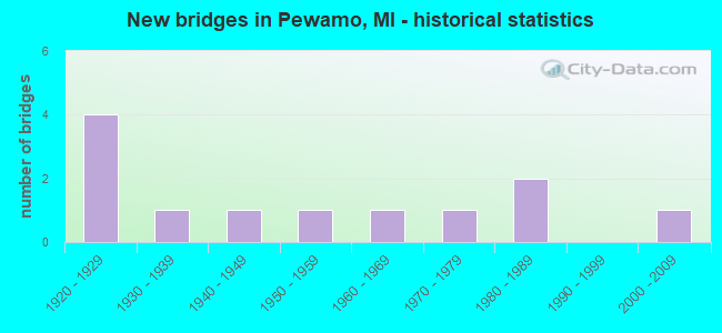
- New bridges - historical statistics
- 41920-1929
- 11930-1939
- 11940-1949
- 11950-1959
- 11960-1969
- 11970-1979
- 21980-1989
- 12000-2009

- Reconstructed bridges - Historical Statistics
- 21970-1979
- 11980-1989
- 11990-1999


- Bridge Condition - Deck
- 20.0%Very good
- 10.0%Good
- 60.0%Satisfactory
- 10.0%Fair

- Bridge Condition - Superstructure
- 20.0%Very good
- 20.0%Good
- 50.0%Satisfactory
- 10.0%Fair

- Bridge Condition - Substructure
- 10.0%Very good
- 30.0%Good
- 20.0%Satisfactory
- 20.0%Fair
- 20.0%Poor

- Bridge Condition - Channel
- 11.1%Very good
- 44.4%Satisfactory
- 22.2%Fair
- 22.2%Poor
Find on map >> Show street view
Structure Number: 1963, Location: 0.7 MI W OF JONES RD (Lat: 42.987992, Lng: -84.830233), Route carried "on" structure: County highway , Year Built: 1920, Year Reconstructed: 1987, Status: Open, Structure Length: 0.88m (2.89ft), Average Daily Traffic: 138 (year 2011), Average Future Daily Traffic: 249 (year 2031), Design Load: HS 20, Features Intersected: LOST CREEK, Facility Carried by Structure: TOWNSEND ROAD
Minimum Vertical Clearance: 30.48m (100.00ft), Kilometerpoint: 1.408, Lanes on structure: 2, Owner: County Highway Agency, Approaching Roadway Width: 9.8m (32.2ft), Material/Design: Prestressed concrete, Design/Construction: Box Beam or Girders - Multiple, Number Of Spans In Main Unit: 1, Length of Maximum Span: 8.2m (26.9ft), Curb-To-Curb Width: 5.2m (17.1ft), Out-to-Out Width: 5.5m (18.0ft)
Condition: Deck: Satisfactory, Superstructure: Satisfactory, Substructure: Fair, Channel: Fair, Operating Rating: 74.4 metric tons, Method Used To Determine Operating Rating: Load Factor (LF), Inventory Rating: 44.7 metric tons, Method Used To Determine Inventory Rating: Load Factor (LF), Structural Evaluation: Somewhat better than minimum adequacy, Deck Geometry: High priority of replacement, Waterway Adequacy: Better than present minimum criteria, Approach Roadway Alignment: Somewhat better than minimum adequacy, Designated Inspection Frequency: Every 24 months, Inspection Date: October 2021, Deck Structure Type: Concrete Precast Panels, Wearing Surface/Protective System: Wearing Surface: Integral Concrete
Find on map >> Show street view
Structure Number: 1965, Location: 0.2 MI N OF TOWNSEND RD (Lat: 42.994092, Lng: -84.818733), Route carried "on" structure: County highway , Year Built: 1924, Year Reconstructed: 1984, Status: Open, Structure Length: 0.67m (2.20ft), Average Daily Traffic: 86 (year 2011), Average Future Daily Traffic: 155 (year 2031), Design Load: HS 20, Features Intersected: LOST CREEK, Facility Carried by Structure: JONES ROAD
Minimum Vertical Clearance: 30.48m (100.00ft), Kilometerpoint: 1.521, Lanes on structure: 2, Owner: County Highway Agency, Approaching Roadway Width: 8.5m (27.9ft), Material/Design: Prestressed concrete, Design/Construction: Box Beam or Girders - Multiple, Number Of Spans In Main Unit: 1, Length of Maximum Span: 6.1m (20.0ft), Curb-To-Curb Width: 5.5m (18.0ft), Out-to-Out Width: 5.5m (18.0ft)
Condition: Deck: Satisfactory, Superstructure: Satisfactory, Substructure: Poor, Channel: Fair, Operating Rating: 72.3 metric tons, Method Used To Determine Operating Rating: Load Factor (LF), Inventory Rating: 43.4 metric tons, Method Used To Determine Inventory Rating: Load Factor (LF), Structural Evaluation: Meets minimum limits, Deck Geometry: Meets minimum limits, Waterway Adequacy: Equal to present minimum criteria, Approach Roadway Alignment: Equal to present minimum criteria, Designated Inspection Frequency: Every 24 months, Inspection Date: October 2021, Deck Structure Type: Concrete Cast-file-Place
Find on map >> Show street view
Structure Number: 1966, Location: 0.2 MI N OF TOWNSEND RD (Lat: 42.996536, Lng: -84.818733), Route carried "on" structure: County highway , Year Built: 1924, Year Reconstructed: 1984, Status: Open, Structure Length: 0.67m (2.20ft), Average Daily Traffic: 86 (year 2011), Average Future Daily Traffic: 155 (year 2031), Design Load: HS 20, Features Intersected: WIEBER CREEK, Facility Carried by Structure: JONES ROAD
Minimum Vertical Clearance: 30.48m (100.00ft), Kilometerpoint: 1.791, Lanes on structure: 2, Owner: County Highway Agency, Approaching Roadway Width: 8.5m (27.9ft), Material/Design: Prestressed concrete, Design/Construction: Box Beam or Girders - Multiple, Number Of Spans In Main Unit: 1, Length of Maximum Span: 6.4m (21.0ft), Curb-To-Curb Width: 5.5m (18.0ft), Out-to-Out Width: 5.5m (18.0ft)
Condition: Deck: Satisfactory, Superstructure: Satisfactory, Substructure: Fair, Channel: Satisfactory, Operating Rating: 72.3 metric tons, Method Used To Determine Operating Rating: Load Factor (LF), Inventory Rating: 43.4 metric tons, Method Used To Determine Inventory Rating: Load Factor (LF), Structural Evaluation: Somewhat better than minimum adequacy, Deck Geometry: Meets minimum limits, Waterway Adequacy: Equal to present minimum criteria, Approach Roadway Alignment: Meets minimum limits, Designated Inspection Frequency: Every 24 months, Inspection Date: October 2021, Deck Structure Type: Concrete Precast Panels
Find on map >> Show street view
Structure Number: 2198, Location: 2 MI N OF FELCH (Lat: 46.027611, Lng: -87.834503), Route carried "on" structure: County highway 2245, Year Built: 1927, Status: Open, Structure Length: 1.05m (3.44ft), Average Daily Traffic: 406 (year 2020), Truck Traffic: 44%, Average Future Daily Traffic: 447 (year 2020), Features Intersected: E BR STURGEON RIVER, Facility Carried by Structure: COUNTY HWY 581
Minimum Vertical Clearance: 30.48m (100.00ft), Kilometerpoint: 1.569, Lanes on structure: 2, Owner: County Highway Agency, Approaching Roadway Width: 6.9m (22.6ft), Material/Design: Concrete, Design/Construction: Girder and Floorbeam System, Number Of Spans In Main Unit: 1, Length of Maximum Span: 9.7m (31.8ft), Curb-To-Curb Width: 6.7m (22.0ft), Out-to-Out Width: 8.1m (26.6ft)
Condition: Deck: Very good, Superstructure: Very good, Substructure: Good, Channel: Very good, Operating Rating: 54.5 metric tons, Method Used To Determine Operating Rating: Field evaluation and documented engineering judgment, Inventory Rating: 32.7 metric tons, Method Used To Determine Inventory Rating: Field evaluation and documented engineering judgment, Structural Evaluation: Better than present minimum criteria, Deck Geometry: Meets minimum limits, Waterway Adequacy: Somewhat better than minimum adequacy, Approach Roadway Alignment: Equal to present desirable criteria, Length Of Structure Improvement: 1.30m (4.27ft), Designated Inspection Frequency: Every 24 months, Underwater Inspection Frequency: Every 60 months, Inspection Date: September 2020, Underwater Inspection Date: August 2019, Bridge Improvement Cost: $183,000, Roadway Improvement Cost: $19,000, Total Project Cost: $253,000, Deck Structure Type: Concrete Cast-file-Place, Wearing Surface/Protective System: Wearing Surface: Bituminous, Membrane: Preformed Fabric
Find on map >> Show street view
Structure Number: 4029, Location: 2 MI N PEWAMO & 2 MI WEST (Lat: 43.032539, Lng: -84.866633), Route carried "on" structure: ServiceCounty highway 3476, Year Built: 1983, Status: Open, Structure Length: 0.61m (2.00ft), Average Daily Traffic: 404 (year 2010), Truck Traffic: 17%, Average Future Daily Traffic: 420 (year 2027), Design Load: HS 20+Mod, Features Intersected: MAPLE RIVER FLOOD, Facility Carried by Structure: NICKLE PLATE RD
Minimum Vertical Clearance: 30.48m (100.00ft), Kilometerpoint: 14.504, Lanes on structure: 2, Owner: County Highway Agency, Approaching Roadway Width: 6.1m (20.0ft), Material/Design: Steel, Design/Construction: Culvert, Number Of Spans In Main Unit: 2, Length of Maximum Span: 2.4m (7.9ft)
Condition: Channel: Poor, Culverts: Serious, Operating Rating: 55.1 metric tons, Method Used To Determine Operating Rating: Load Factor (LF) rating reported by rating factor (RF) method using MS18 loading, Inventory Rating: 33.0 metric tons, Method Used To Determine Inventory Rating: Load Factor (LF) rating reported by rating factor (RF) method using MS18 loading, Structural Evaluation: High priority of corrective action, Waterway Adequacy: Somewhat better than minimum adequacy, Approach Roadway Alignment: Equal to present desirable criteria, Designated Inspection Frequency: Every 12 months, Inspection Date: October 2021
Find on map >> Show street view
Structure Number: 403, Location: 2 MI N OF PEWAMO & 1 MI W (Lat: 43.032558, Lng: -84.861867), Route carried "on" structure: ServiceCounty highway 3476, Year Built: 1983, Status: Open, Structure Length: 5.94m (19.49ft), Average Daily Traffic: 123 (year 2013), Truck Traffic: 16%, Average Future Daily Traffic: 150 (year 2033), Design Load: HS 20+Mod, Features Intersected: MAPLE RIVER, Facility Carried by Structure: NICKLE PLATE RD
Minimum Vertical Clearance: 30.48m (100.00ft), Kilometerpoint: 15.859, Lanes on structure: 2, Owner: County Highway Agency, Approaching Roadway Width: 6.1m (20.0ft), Material/Design: Prestressed concrete, Design/Construction: Box Beam or Girders - Multiple, Number Of Spans In Main Unit: 3, Length of Maximum Span: 19.8m (65.0ft), Curb-To-Curb Width: 9.1m (29.9ft), Out-to-Out Width: 10.6m (34.8ft)
Condition: Deck: Satisfactory, Superstructure: Satisfactory, Substructure: Good, Channel: Satisfactory, Operating Rating: 70.0 metric tons, Method Used To Determine Operating Rating: Load Factor (LF) rating reported by rating factor (RF) method using MS18 loading, Inventory Rating: 41.8 metric tons, Method Used To Determine Inventory Rating: Load Factor (LF) rating reported by rating factor (RF) method using MS18 loading, Structural Evaluation: Equal to present minimum criteria, Deck Geometry: Equal to present minimum criteria, Waterway Adequacy: Equal to present desirable criteria, Approach Roadway Alignment: Equal to present desirable criteria, Designated Inspection Frequency: Every 24 months, Underwater Inspection Frequency: Every 24 months, Inspection Date: October 2021, Underwater Inspection Date: October 2020, Deck Structure Type: Concrete Cast-file-Place, Wearing Surface/Protective System: Wearing Surface: Monolithic Concrete, Deck Protection: Epoxy Coated Reinforcing
Find on map >> Show street view
Structure Number: 4047, Location: .5 MI S PEWAMO VILL LIMIT (Lat: 42.987583, Lng: -84.847289), Route carried "on" structure: ServiceCounty highway 3456, Year Built: 1959, Status: Posted for load, Structure Length: 4.11m (13.48ft), Average Daily Traffic: 1,201 (year 2007), Truck Traffic: 8%, Average Future Daily Traffic: 1,397 (year 2027), Design Load: HS 20+Mod, Features Intersected: STONEY CREEK, Facility Carried by Structure: HUBBARDSTON ROAD
Minimum Vertical Clearance: 30.48m (100.00ft), Kilometerpoint: 1.614, Lanes on structure: 2, Owner: County Highway Agency, Approaching Roadway Width: 9.1m (29.9ft), Skew: 4 degrees, Material/Design: Prestressed concrete, Design/Construction: Box Beam or Girders - Multiple, Number Of Spans In Main Unit: 3, Length of Maximum Span: 13.7m (44.9ft), Curb or Sidewalk Widths: Left: 0.4m (1.3ft), Right: 0.4m (1.3ft), Curb-To-Curb Width: 9.1m (29.9ft), Out-to-Out Width: 10.3m (33.8ft)
Condition: Deck: Satisfactory, Superstructure: Satisfactory, Substructure: Satisfactory, Channel: Satisfactory, Operating Rating: 37.9 metric tons, Method Used To Determine Operating Rating: Load Factor (LF) rating reported by rating factor (RF) method using MS18 loading, Inventory Rating: 22.7 metric tons, Method Used To Determine Inventory Rating: Load Factor (LF) rating reported by rating factor (RF) method using MS18 loading, Structural Evaluation: Equal to present minimum criteria, Deck Geometry: Somewhat better than minimum adequacy, Waterway Adequacy: Better than present minimum criteria, Approach Roadway Alignment: Better than present minimum criteria, Bridge Posting: Required (Relationship of Operating Rating to Maximum Legal Load: 20.0 - 29.9% below), Designated Inspection Frequency: Every 24 months, Inspection Date: October 2021, Deck Structure Type: Concrete Precast Panels, Wearing Surface/Protective System: Wearing Surface: Bituminous
Find on map >> Show street view
Structure Number: 5947, Location: IN ST IGNACE (Lat: 45.877156, Lng: -84.738889), Route carried "on" structure: Interstate 75, Year Built: 1960, Status: Open, Structure Length: 8.47m (27.79ft), Average Daily Traffic: 2,555 (year 2007), Truck Traffic: 8%, Average Future Daily Traffic: 6,165 (year 2018), Design Load: HS 20+Mod, Features Intersected: CHEESEMAN RD & RR (ABN)
Minimum Vertical Clearance: 30+ m (98+ ft), Kilometerpoint: 10.394, Lanes on structure: 2, Lanes under structure: 2, Base Highway Network: Yes (Inventory Route: 114, Subroute: 7), Owner: State Highway Agency, Approaching Roadway Width: 10.9m (35.8ft), Skew: 13 degrees, Material/Design: Steel, Design/Construction: Stringer/Multi-beam, Number Of Spans In Main Unit: 4, Length of Maximum Span: 21.9m (71.9ft), Curb-To-Curb Width: 10.3m (33.8ft), Out-to-Out Width: 10.6m (34.8ft)
Condition: Deck: Fair, Superstructure: Fair, Substructure: Poor, Operating Rating: 81.0 metric tons, Method Used To Determine Operating Rating: Load Factor (LF) rating reported by rating factor (RF) method using MS18 loading, Inventory Rating: 48.6 metric tons, Method Used To Determine Inventory Rating: Load Factor (LF) rating reported by rating factor (RF) method using MS18 loading, Structural Evaluation: Meets minimum limits, Deck Geometry: Meets minimum limits, Underclear: Somewhat better than minimum adequacy, Approach Roadway Alignment: Better than present minimum criteria, Designated Inspection Frequency: Every 12 months, Inspection Date: May 2021, Bridge Improvement Cost: $171,000, Deck Structure Type: Concrete Cast-file-Place, Wearing Surface/Protective System: Wearing Surface: Latex Concrete
Find on map >> Show street view
Structure Number: 6885, Location: 0.8 MI N OF US-10 (Lat: 43.741969, Lng: -84.486867), Route carried "on" structure: State highway 18, Year Built: 2001, Status: Open, Structure Length: 3.04m (9.97ft), Average Daily Traffic: 4,766 (year 2007), Truck Traffic: 5%, Average Future Daily Traffic: 5,965 (year 2018), Design Load: HS 25 or greater, Features Intersected: BLUFF CREEK
Minimum Vertical Clearance: 30.48m (100.00ft), Kilometerpoint: 3.547, Lanes on structure: 2, Base Highway Network: Yes (Inventory Route: 88, Subroute: 4), Owner: State Highway Agency, Approaching Roadway Width: 13.6m (44.6ft), Material/Design: Prestressed concrete, Design/Construction: Stringer/Multi-beam, Number Of Spans In Main Unit: 1, Length of Maximum Span: 30.4m (99.7ft), Curb-To-Curb Width: 13.7m (44.9ft), Out-to-Out Width: 14.4m (47.2ft)
Condition: Deck: Very good, Superstructure: Very good, Substructure: Very good, Channel: Satisfactory, Operating Rating: 49.2 metric tons, Method Used To Determine Operating Rating: Load and Resistance Factor Rating (LRFR) rating reported by rating factor(RF) method using HL-93 loadings, Inventory Rating: 38.2 metric tons, Method Used To Determine Inventory Rating: Load and Resistance Factor Rating (LRFR) rating reported by rating factor(RF) method using HL-93 loadings, Structural Evaluation: Equal to present desirable criteria, Deck Geometry: Superior to present desirable criteria, Waterway Adequacy: Equal to present minimum criteria, Approach Roadway Alignment: Equal to present minimum criteria, Designated Inspection Frequency: Every 24 months, Inspection Date: June 2020, Deck Structure Type: Concrete Cast-file-Place, Wearing Surface/Protective System: Wearing Surface: Monolithic Concrete, Deck Protection: Epoxy Coated Reinforcing
Find on map >> Show street view
Structure Number: 7255, Location: 2. MI NO OF M 50 (Lat: 41.986786, Lng: -83.673158), Route carried "on" structure: County highway 5817, Year Built: 1947, Year Reconstructed: 1990, Status: Open, Structure Length: 4.11m (13.48ft), Average Daily Traffic: 3,140 (year 2017), Truck Traffic: 15%, Average Future Daily Traffic: 3,611 (year 2037), Design Load: HS 20, Features Intersected: MACON RIVER, Facility Carried by Structure: ANN ARBOR ROAD
Minimum Vertical Clearance: 30.48m (100.00ft), Kilometerpoint: 3.129, Lanes on structure: 2, Owner: County Highway Agency, Approaching Roadway Width: 11.9m (39.0ft), Skew: 2 degrees, Material/Design: Steel, Design/Construction: Stringer/Multi-beam, Number Of Spans In Main Unit: 3, Length of Maximum Span: 16.6m (54.5ft), Curb-To-Curb Width: 13.9m (45.6ft), Out-to-Out Width: 14.6m (47.9ft)
Condition: Deck: Good, Superstructure: Good, Substructure: Satisfactory, Channel: Poor, Operating Rating: 97.2 metric tons, Method Used To Determine Operating Rating: Load Factor (LF) rating reported by rating factor (RF) method using MS18 loading, Inventory Rating: 73.5 metric tons, Method Used To Determine Inventory Rating: Load Factor (LF) rating reported by rating factor (RF) method using MS18 loading, Structural Evaluation: Equal to present minimum criteria, Deck Geometry: Superior to present desirable criteria, Waterway Adequacy: Equal to present minimum criteria, Approach Roadway Alignment: Equal to present desirable criteria, Designated Inspection Frequency: Every 24 months, Inspection Date: July 2020, Deck Structure Type: Concrete Cast-file-Place, Wearing Surface/Protective System: Wearing Surface: Monolithic Concrete
Find on map >> Show street view
Structure Number: 1196, Location: IN LIVONIA (Lat: 42.381047, Lng: -83.437097), Route carried "on" structure: Interstate 275, Year Built: 1971, Status: Open, Structure Length: 8.69m (28.51ft), Average Daily Traffic: 63,050 (year 2013), Truck Traffic: 7%, Average Future Daily Traffic: 72,508 (year 2033), Design Load: HS 20, Features Intersected: CSX RR
Minimum Vertical Clearance: 30.48m (100.00ft), Kilometerpoint: 34.441, Lanes on structure: 4, Base Highway Network: Yes (Inventory Route: 160, Subroute: 10), Owner: State Highway Agency, Approaching Roadway Width: 20.4m (66.9ft), Material/Design: Steel, Design/Construction: Stringer/Multi-beam, Number Of Spans In Main Unit: 4, Length of Maximum Span: 27.7m (90.9ft), Curb-To-Curb Width: 18.9m (62.0ft), Out-to-Out Width: 19.7m (64.6ft)
Condition: Deck: Satisfactory, Superstructure: Good, Substructure: Good, Operating Rating: 59.6 metric tons, Method Used To Determine Operating Rating: Load Factor (LF) rating reported by rating factor (RF) method using MS18 loading, Inventory Rating: 35.6 metric tons, Method Used To Determine Inventory Rating: Load Factor (LF) rating reported by rating factor (RF) method using MS18 loading, Structural Evaluation: Better than present minimum criteria, Deck Geometry: Meets minimum limits, Approach Roadway Alignment: Equal to present desirable criteria, Designated Inspection Frequency: Every 24 months, Inspection Date: October 2021, Deck Structure Type: Concrete Cast-file-Place, Wearing Surface/Protective System: Wearing Surface: Latex Concrete
Find on map >> Show street view
Structure Number: 4013, Location: 1.0 MI W OF PEWAMO (Lat: 42.998858, Lng: -84.868381), Route carried "under" structure: State highway 21, Year Built: 1932, Structure Length: 0. m, Average Daily Traffic: 2,533 (year 2007), Truck Traffic: 13%, Features Intersected: M-21, Facility Carried by Structure: FREDMEIJER CIS TRL
Minimum Vertical Clearance: 4.39m (14.40ft), Kilometerpoint: 0.600, Lanes under structure: 2, Material/Design: Steel, Design/Construction: Girder and Floorbeam System, Length of Maximum Span: 26.2m (86.0ft)