Bridge Statistics for Petoskey, Michigan (MI)
Condition, Traffic, Stress, Structural Evaluation, Project Costs
- National Bridge Inventory (NBI) Statistics
- 24Number of bridges
- 210ft / 63.8mTotal length
- $33,325,000Total costs
- 163,993Total average daily traffic
- 13,819Total average daily truck traffic
- National Bridge Inventory (NBI) Registered Bridges for Petoskey
- No street view available for this location
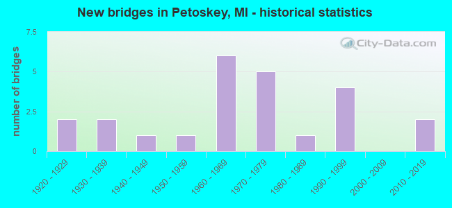
- New bridges - historical statistics
- 21920-1929
- 21930-1939
- 11940-1949
- 11950-1959
- 61960-1969
- 51970-1979
- 11980-1989
- 41990-1999
- 22010-2019

- Reconstructed bridges - Historical Statistics
- 11940-1949
- 01950-1959
- 01960-1969
- 01970-1979
- 11980-1989
- 01990-1999
- 12000-2009
- 12010-2019


- Bridge Condition - Deck
- 17.6%Very good
- 47.1%Good
- 23.5%Satisfactory
- 11.8%Fair

- Bridge Condition - Superstructure
- 29.4%Very good
- 23.5%Good
- 35.3%Satisfactory
- 11.8%Fair

- Bridge Condition - Substructure
- 23.5%Very good
- 41.2%Good
- 17.6%Satisfactory
- 17.6%Fair

- Bridge Condition - Channel
- 4.5%Excellent
- 13.6%Very good
- 27.3%Good
- 22.7%Satisfactory
- 31.8%Fair

- Bridge Condition - Culverts
- 33.3%Satisfactory
- 66.7%Fair
Find on map >> Show street view
Structure Number: 1431, Location: 0.5 MI W OF DOWAGIAC (Lat: 41.983992, Lng: -86.131622), Route carried "on" structure: State highway 62, Year Built: 1954, Status: Open, Structure Length: 1.52m (4.99ft), Average Daily Traffic: 5,340 (year 2012), Truck Traffic: 4%, Average Future Daily Traffic: 6,247 (year 2032), Design Load: HS 20, Features Intersected: DOWAGIAC CREEK
Minimum Vertical Clearance: 30.48m (100.00ft), Kilometerpoint: 0.694, Lanes on structure: 2, Owner: State Highway Agency, Approaching Roadway Width: 12.2m (40.0ft), Skew: 3 degrees, Material/Design: Steel, Design/Construction: Stringer/Multi-beam, Number Of Spans In Main Unit: 1, Length of Maximum Span: 14.5m (47.6ft), Curb-To-Curb Width: 11.6m (38.1ft), Out-to-Out Width: 13.2m (43.3ft)
Condition: Deck: Satisfactory, Superstructure: Fair, Substructure: Good, Channel: Fair, Operating Rating: 97.2 metric tons, Method Used To Determine Operating Rating: Load Factor (LF) rating reported by rating factor (RF) method using MS18 loading, Inventory Rating: 59.3 metric tons, Method Used To Determine Inventory Rating: Load Factor (LF) rating reported by rating factor (RF) method using MS18 loading, Structural Evaluation: Somewhat better than minimum adequacy, Deck Geometry: Somewhat better than minimum adequacy, Waterway Adequacy: Equal to present desirable criteria, Approach Roadway Alignment: Equal to present desirable criteria, Designated Inspection Frequency: Every 24 months, Inspection Date: April 2021, Deck Structure Type: Concrete Cast-file-Place, Wearing Surface/Protective System: Wearing Surface: Latex Concrete
Find on map >> Show street view
Structure Number: 2446, Location: IN PETOSKEY (MITCHELL ST) (Lat: 45.374031, Lng: -84.960517), Route carried "on" structure: US 31, Year Built: 1930, Status: Open, Structure Length: 8.07m (26.48ft), Average Daily Traffic: 28,667 (year 2007), Truck Traffic: 3%, Average Future Daily Traffic: 33,554 (year 2018), Design Load: H 15, Features Intersected: BEAR CREEK
Minimum Vertical Clearance: 30.48m (100.00ft), Kilometerpoint: 10.299, Lanes on structure: 4, Base Highway Network: Yes (Inventory Route: 116, Subroute: 1), Owner: State Highway Agency, Approaching Roadway Width: 13.7m (44.9ft), Material/Design: Concrete, Design/Construction: Tee Beam, Number Of Spans In Main Unit: 7, Length of Maximum Span: 13.7m (44.9ft), Curb or Sidewalk Widths: Left: 1.8m (5.9ft), Right: 1.8m (5.9ft), Curb-To-Curb Width: 12.2m (40.0ft), Out-to-Out Width: 16.9m (55.4ft)
Condition: Deck: Fair, Superstructure: Satisfactory, Substructure: Fair, Channel: Very good, Operating Rating: 53.8 metric tons, Method Used To Determine Operating Rating: Load Factor (LF) rating reported by rating factor (RF) method using MS18 loading, Inventory Rating: 32.4 metric tons, Method Used To Determine Inventory Rating: Load Factor (LF) rating reported by rating factor (RF) method using MS18 loading, Structural Evaluation: Somewhat better than minimum adequacy, Deck Geometry: High priority of replacement, Waterway Adequacy: Superior to present desirable criteria, Approach Roadway Alignment: Better than present minimum criteria, Designated Inspection Frequency: Every 24 months, Inspection Date: July 2021, Deck Structure Type: Concrete Cast-file-Place, Wearing Surface/Protective System: Wearing Surface: Epoxy Overlay, Membrane: Other
Find on map >> Show street view
Structure Number: 2461, Location: IN PETOSKEY (Lat: 45.368628, Lng: -84.965367), Route carried "on" structure: Business City street 2051, Year Built: 1976, Status: Posted for load, Structure Length: 5.48m (17.98ft), Average Daily Traffic: 2,382 (year 2018), Truck Traffic: 7%, Average Future Daily Traffic: 2,620 (year 2038), Design Load: HS 20, Features Intersected: BEAR RIVER, Facility Carried by Structure: BRIDGE STREET
Minimum Vertical Clearance: 30.48m (100.00ft), Kilometerpoint: 0.068, Lanes on structure: 2, Owner: City or Municipal Highway Agency, Approaching Roadway Width: 11.5m (37.7ft), Skew: 9 degrees, Material/Design: Prestressed concrete, Design/Construction: Stringer/Multi-beam, Number Of Spans In Main Unit: 3, Length of Maximum Span: 18.2m (59.7ft), Curb or Sidewalk Widths: Left: 0.0m, Right: 1.5m (4.9ft), Curb-To-Curb Width: 9.1m (29.9ft), Out-to-Out Width: 11.6m (38.1ft)
Condition: Deck: Very good, Superstructure: Good, Substructure: Very good, Channel: Excellent, Operating Rating: 30.5 metric tons, Method Used To Determine Operating Rating: Load and Resistance Factor Rating (LRFR) rating reported by rating factor(RF) method using HL-93 loadings, Inventory Rating: 23.3 metric tons, Method Used To Determine Inventory Rating: Load and Resistance Factor Rating (LRFR) rating reported by rating factor(RF) method using HL-93 loadings, Structural Evaluation: Equal to present minimum criteria, Deck Geometry: Meets minimum limits, Waterway Adequacy: Superior to present desirable criteria, Approach Roadway Alignment: Equal to present desirable criteria, Bridge Posting: Required (Relationship of Operating Rating to Maximum Legal Load: 10.0 - 19.9% below), Designated Inspection Frequency: Every 24 months, Inspection Date: September 2020, Deck Structure Type: Concrete Cast-file-Place, Wearing Surface/Protective System: Wearing Surface: Monolithic Concrete
Find on map >> Show street view
Structure Number: 2462, Location: IN PETOSKEY (Lat: 45.374994, Lng: -84.960717), Route carried "on" structure: City street , Year Built: 1993, Status: Open, Structure Length: 1.95m (6.40ft), Average Daily Traffic: 800 (year 1990), Truck Traffic: 10%, Average Future Daily Traffic: 1,200 (year 2015), Design Load: HS 20, Features Intersected: BEAR RIVER, Facility Carried by Structure: LAKE STREET
Minimum Vertical Clearance: 30.48m (100.00ft), Kilometerpoint: 0.941, Lanes on structure: 2, Owner: City or Municipal Highway Agency, Approaching Roadway Width: 11.0m (36.1ft), Skew: 1 degrees, Material/Design: Prestressed concrete, Design/Construction: Box Beam or Girders - Multiple, Number Of Spans In Main Unit: 1, Length of Maximum Span: 19.2m (63.0ft), Curb or Sidewalk Widths: Left: 2.8m (9.2ft), Right: 2.8m (9.2ft), Curb-To-Curb Width: 11.0m (36.1ft), Out-to-Out Width: 17.1m (56.1ft)
Condition: Deck: Satisfactory, Superstructure: Good, Substructure: Very good, Channel: Very good, Operating Rating: 62.9 metric tons, Method Used To Determine Operating Rating: Load Factor (LF) rating reported by rating factor (RF) method using MS18 loading, Inventory Rating: 37.6 metric tons, Method Used To Determine Inventory Rating: Load Factor (LF) rating reported by rating factor (RF) method using MS18 loading, Structural Evaluation: Better than present minimum criteria, Deck Geometry: Better than present minimum criteria, Waterway Adequacy: Superior to present desirable criteria, Approach Roadway Alignment: Equal to present desirable criteria, Designated Inspection Frequency: Every 24 months, Inspection Date: September 2020, Deck Structure Type: Concrete Precast Panels, Wearing Surface/Protective System: Wearing Surface: Bituminous, Membrane: Preformed Fabric
Find on map >> Show street view
Structure Number: 2463, Location: IN PETOSKEY (Lat: 45.358978, Lng: -84.956528), Route carried "on" structure: City street , Year Built: 1998, Status: Open, Structure Length: 1.64m (5.38ft), Average Daily Traffic: 2,238 (year 1988), Truck Traffic: 10%, Average Future Daily Traffic: 4,050 (year 2012), Design Load: HS 20, Features Intersected: BEAR RIVER, Facility Carried by Structure: STANDISH STREET
Minimum Vertical Clearance: 30.48m (100.00ft), Kilometerpoint: 7.601, Lanes on structure: 2, Owner: City or Municipal Highway Agency, Approaching Roadway Width: 9.1m (29.9ft), Material/Design: Wood or Timber, Design/Construction: Stringer/Multi-beam, Number Of Spans In Main Unit: 1, Length of Maximum Span: 16.4m (53.8ft), Curb or Sidewalk Widths: Left: 0.0m, Right: 1.8m (5.9ft), Curb-To-Curb Width: 11.3m (37.1ft), Out-to-Out Width: 11.9m (39.0ft)
Condition: Deck: Good, Superstructure: Very good, Substructure: Very good, Channel: Good, Operating Rating: 64.2 metric tons, Method Used To Determine Operating Rating: Allowable Stress (AS) rating reported by rating factor (RF) method using MS18 loading, Inventory Rating: 43.7 metric tons, Method Used To Determine Inventory Rating: Allowable Stress (AS) rating reported by rating factor (RF) method using MS18 loading, Structural Evaluation: Equal to present desirable criteria, Deck Geometry: Somewhat better than minimum adequacy, Waterway Adequacy: Superior to present desirable criteria, Approach Roadway Alignment: Equal to present desirable criteria, Designated Inspection Frequency: Every 24 months, Inspection Date: September 2020, Deck Structure Type: Wood or Timber, Wearing Surface/Protective System: Wearing Surface: Bituminous, Membrane: Preformed Fabric
Find on map >> Show street view
Structure Number: 2731, Location: BET GENESEE & VASSAR ROAD (Lat: 43.121072, Lng: -83.596247), Route carried "on" structure: County highway 2002, Year Built: 1927, Status: Posted for load, Structure Length: 0.82m (2.69ft), Average Daily Traffic: 3,115 (year 2016), Truck Traffic: 5%, Average Future Daily Traffic: 5,620 (year 2036), Design Load: HS 20+Mod, Features Intersected: BUTTERNUT CREEK, Facility Carried by Structure: MT MORRIS ROAD
Minimum Vertical Clearance: 30.48m (100.00ft), Kilometerpoint: 7.992, Lanes on structure: 2, Owner: County Highway Agency, Approaching Roadway Width: 11.0m (36.1ft), Material/Design: Concrete, Design/Construction: Tee Beam, Number Of Spans In Main Unit: 1, Length of Maximum Span: 7.3m (24.0ft), Curb-To-Curb Width: 11.0m (36.1ft), Out-to-Out Width: 11.5m (37.7ft)
Condition: Deck: Satisfactory, Superstructure: Satisfactory, Substructure: Satisfactory, Channel: Satisfactory, Operating Rating: 24.6 metric tons, Method Used To Determine Operating Rating: Load Factor (LF) rating reported by rating factor (RF) method using MS18 loading, Inventory Rating: 14.9 metric tons, Method Used To Determine Inventory Rating: Load Factor (LF) rating reported by rating factor (RF) method using MS18 loading, Structural Evaluation: Meets minimum limits, Deck Geometry: Somewhat better than minimum adequacy, Waterway Adequacy: Equal to present minimum criteria, Approach Roadway Alignment: Better than present minimum criteria, Bridge Posting: Required (Relationship of Operating Rating to Maximum Legal Load: 30.0 - 39.9% below), Designated Inspection Frequency: Every 12 months, Inspection Date: November 2021, Deck Structure Type: Concrete Cast-file-Place, Wearing Surface/Protective System: Wearing Surface: Bituminous
Find on map >> Show street view
Structure Number: 2751, Location: BET DAVISON & RICHFIELD (Lat: 43.040767, Lng: -83.595856), Route carried "on" structure: City street 2002, Year Built: 1994, Status: Open, Structure Length: 2.37m (7.78ft), Average Daily Traffic: 12,023 (year 1998), Truck Traffic: 5%, Average Future Daily Traffic: 21,715 (year 2018), Design Load: HS 20, Features Intersected: KEARSLEY CREEK, Facility Carried by Structure: BELSAY ROAD
Minimum Vertical Clearance: 30.48m (100.00ft), Kilometerpoint: 8.845, Lanes on structure: 5, Owner: City or Municipal Highway Agency, Approaching Roadway Width: 18.9m (62.0ft), Skew: 2 degrees, Material/Design: Prestressed concrete, Design/Construction: Box Beam or Girders - Multiple, Number Of Spans In Main Unit: 1, Length of Maximum Span: 22.2m (72.8ft), Curb or Sidewalk Widths: Left: 1.7m (5.6ft), Right: 1.7m (5.6ft), Curb-To-Curb Width: 20.1m (65.9ft), Out-to-Out Width: 23.7m (77.8ft)
Condition: Deck: Good, Superstructure: Very good, Substructure: Good, Channel: Good, Operating Rating: 74.5 metric tons, Method Used To Determine Operating Rating: Load Factor (LF) rating reported by rating factor (RF) method using MS18 loading, Inventory Rating: 44.7 metric tons, Method Used To Determine Inventory Rating: Load Factor (LF) rating reported by rating factor (RF) method using MS18 loading, Structural Evaluation: Better than present minimum criteria, Deck Geometry: Somewhat better than minimum adequacy, Waterway Adequacy: Equal to present minimum criteria, Approach Roadway Alignment: Equal to present desirable criteria, Designated Inspection Frequency: Every 24 months, Inspection Date: August 2021, Deck Structure Type: Concrete Cast-file-Place, Wearing Surface/Protective System: Wearing Surface: Integral Concrete, Deck Protection: Epoxy Coated Reinforcing
Find on map >> Show street view
Structure Number: 7701, Location: IN NORTH MUSKEGON (Lat: 43.243133, Lng: -86.295861), Route carried "on" structure: City street 2007, Year Built: 1971, Status: Posted for load, Structure Length: 1.52m (4.99ft), Average Daily Traffic: 10,550 (year 2004), Truck Traffic: 5%, Average Future Daily Traffic: 19,050 (year 2024), Design Load: H 20, Features Intersected: BEAR LAKE CHANNEL, Facility Carried by Structure: RUDDIMAN AVENUE
Minimum Vertical Clearance: 30.48m (100.00ft), Kilometerpoint: 4.994, Lanes on structure: 2, Owner: City or Municipal Highway Agency, Approaching Roadway Width: 9.8m (32.2ft), Material/Design: Steel, Design/Construction: Stringer/Multi-beam, Number Of Spans In Main Unit: 1, Length of Maximum Span: 14.5m (47.6ft), Curb or Sidewalk Widths: Left: 0.2m (0.7ft), Right: 1.8m (5.9ft), Curb-To-Curb Width: 9.8m (32.2ft), Out-to-Out Width: 12.4m (40.7ft)
Condition: Deck: Fair, Superstructure: Satisfactory, Substructure: Fair, Channel: Good, Operating Rating: 37.6 metric tons, Method Used To Determine Operating Rating: Load Factor (LF) rating reported by rating factor (RF) method using MS18 loading, Inventory Rating: 22.7 metric tons, Method Used To Determine Inventory Rating: Load Factor (LF) rating reported by rating factor (RF) method using MS18 loading, Structural Evaluation: Somewhat better than minimum adequacy, Deck Geometry: Meets minimum limits, Waterway Adequacy: Superior to present desirable criteria, Approach Roadway Alignment: Equal to present minimum criteria, Bridge Posting: Required (Relationship of Operating Rating to Maximum Legal Load: 20.0 - 29.9% below), Length Of Structure Improvement: 1.52m (4.99ft), Designated Inspection Frequency: Every 12 months, Inspection Date: March 2021, Bridge Improvement Cost: $25,000,000, Roadway Improvement Cost: $8,000,000, Total Project Cost: $33,000,000, Deck Structure Type: Concrete Cast-file-Place, Wearing Surface/Protective System: Wearing Surface: Latex Concrete
Find on map >> Show street view
Structure Number: 8352, Location: 1.0 MI W OF HART (Lat: 43.703775, Lng: -86.392817), Route carried "on" structure: County highway 6454, Year Built: 1976, Status: Open, Structure Length: 11.28m (37.01ft), Average Daily Traffic: 1,000 (year 1993), Truck Traffic: 6%, Average Future Daily Traffic: 1,200 (year 2010), Design Load: H 20, Features Intersected: US-31, Facility Carried by Structure: TYLER ROAD
Minimum Vertical Clearance: 30.48m (100.00ft), Kilometerpoint: 9.013, Lanes on structure: 2, Lanes under structure: 4, Owner: State Highway Agency, Approaching Roadway Width: 12.2m (40.0ft), Material/Design: Steel, Design/Construction: Stringer/Multi-beam, Number Of Spans In Main Unit: 5, Length of Maximum Span: 30.4m (99.7ft), Curb-To-Curb Width: 12.8m (42.0ft), Out-to-Out Width: 13.5m (44.3ft)
Condition: Deck: Good, Superstructure: Good, Substructure: Good, Operating Rating: 84.2 metric tons, Method Used To Determine Operating Rating: Load Factor (LF) rating reported by rating factor (RF) method using MS18 loading, Inventory Rating: 50.5 metric tons, Method Used To Determine Inventory Rating: Load Factor (LF) rating reported by rating factor (RF) method using MS18 loading, Structural Evaluation: Better than present minimum criteria, Deck Geometry: Superior to present desirable criteria, Underclear: Better than present minimum criteria, Approach Roadway Alignment: Equal to present desirable criteria, Designated Inspection Frequency: Every 24 months, Inspection Date: November 2021, Bridge Improvement Cost: $386,000, Roadway Improvement Cost: $28,000, Total Project Cost: $325,000, Deck Structure Type: Concrete Cast-file-Place, Wearing Surface/Protective System: Wearing Surface: Monolithic Concrete
Find on map >> Show street view
Structure Number: 8362, Location: 9.4 MI E OF US-31 (Lat: 43.570922, Lng: -86.212817), Route carried "on" structure: State highway 20, Year Built: 1963, Status: Open, Structure Length: 4.17m (13.68ft), Average Daily Traffic: 2,034 (year 2007), Truck Traffic: 11%, Average Future Daily Traffic: 2,453 (year 2018), Design Load: HS 20, Features Intersected: N BR WHITE RIVER
Minimum Vertical Clearance: 30.48m (100.00ft), Kilometerpoint: 23.752, Lanes on structure: 2, Base Highway Network: Yes (Inventory Route: 364, Subroute: 72), Owner: State Highway Agency, Approaching Roadway Width: 15.2m (49.9ft), Material/Design: Prestressed concrete, Design/Construction: Stringer/Multi-beam, Number Of Spans In Main Unit: 3, Length of Maximum Span: 14.0m (45.9ft), Curb or Sidewalk Widths: Left: 0.1m (0.3ft), Right: 0.1m (0.3ft), Curb-To-Curb Width: 13.7m (44.9ft), Out-to-Out Width: 14.4m (47.2ft)
Condition: Deck: Satisfactory, Superstructure: Satisfactory, Substructure: Fair, Channel: Fair, Operating Rating: 53.5 metric tons, Method Used To Determine Operating Rating: Load Factor (LF) rating reported by rating factor (RF) method using MS18 loading, Inventory Rating: 32.1 metric tons, Method Used To Determine Inventory Rating: Load Factor (LF) rating reported by rating factor (RF) method using MS18 loading, Structural Evaluation: Somewhat better than minimum adequacy, Deck Geometry: Superior to present desirable criteria, Waterway Adequacy: Better than present minimum criteria, Approach Roadway Alignment: Better than present minimum criteria, Designated Inspection Frequency: Every 24 months, Inspection Date: April 2020, Deck Structure Type: Concrete Cast-file-Place, Wearing Surface/Protective System: Wearing Surface: Monolithic Concrete
Find on map >> Show street view
Structure Number: 8762, Location: 2.7 MI W OF KENT CO LINE (Lat: 42.972131, Lng: -85.839700), Route carried "on" structure: State highway 45, Year Built: 1999, Status: Open, Structure Length: 2.00m (6.56ft), Average Daily Traffic: 18,856 (year 2007), Truck Traffic: 5%, Average Future Daily Traffic: 26,942 (year 2018), Design Load: HS 25 or greater, Features Intersected: SAND CREEK
Minimum Vertical Clearance: 30.48m (100.00ft), Kilometerpoint: 9.880, Lanes on structure: 6, Owner: State Highway Agency, Approaching Roadway Width: 28.4m (93.2ft), Material/Design: Prestressed concrete, Design/Construction: Stringer/Multi-beam, Number Of Spans In Main Unit: 1, Length of Maximum Span: 20.0m (65.6ft), Curb-To-Curb Width: 29.3m (96.1ft), Out-to-Out Width: 30.4m (99.7ft)
Condition: Deck: Good, Superstructure: Very good, Substructure: Good, Channel: Good, Operating Rating: 70.0 metric tons, Method Used To Determine Operating Rating: Load Factor (LF) rating reported by rating factor (RF) method using MS18 loading, Inventory Rating: 41.8 metric tons, Method Used To Determine Inventory Rating: Load Factor (LF) rating reported by rating factor (RF) method using MS18 loading, Structural Evaluation: Better than present minimum criteria, Deck Geometry: Superior to present desirable criteria, Waterway Adequacy: Equal to present desirable criteria, Approach Roadway Alignment: Better than present minimum criteria, Designated Inspection Frequency: Every 24 months, Inspection Date: August 2021, Deck Structure Type: Concrete Cast-file-Place, Wearing Surface/Protective System: Wearing Surface: Integral Concrete, Deck Protection: Epoxy Coated Reinforcing
Find on map >> Show street view
Structure Number: 10672, Location: SEC 11-14 WISNER TWP (Lat: 43.623442, Lng: -83.604250), Route carried "on" structure: ServiceCounty highway , Year Built: 1967, Status: Open, Structure Length: 1.13m (3.71ft), Average Daily Traffic: 75 (year 2009), Average Future Daily Traffic: 135 (year 2029), Design Load: H 15, Features Intersected: NORTHWEST DRAIN OUTLET 3, Facility Carried by Structure: CARSON ROAD
Minimum Vertical Clearance: 30.48m (100.00ft), Kilometerpoint: 0.803, Lanes on structure: 2, Owner: County Highway Agency, Approaching Roadway Width: 8.5m (27.9ft), Material/Design: Steel, Design/Construction: Stringer/Multi-beam, Number Of Spans In Main Unit: 1, Length of Maximum Span: 10.8m (35.4ft), Curb-To-Curb Width: 7.8m (25.6ft), Out-to-Out Width: 8.2m (26.9ft)
Condition: Deck: Good, Superstructure: Satisfactory, Substructure: Good, Channel: Good, Operating Rating: 44.7 metric tons, Method Used To Determine Operating Rating: Load Factor (LF) rating reported by rating factor (RF) method using MS18 loading, Inventory Rating: 26.9 metric tons, Method Used To Determine Inventory Rating: Load Factor (LF) rating reported by rating factor (RF) method using MS18 loading, Structural Evaluation: Equal to present minimum criteria, Deck Geometry: Equal to present minimum criteria, Waterway Adequacy: Better than present minimum criteria, Approach Roadway Alignment: Equal to present minimum criteria, Bridge Posting: Required (Relationship of Operating Rating to Maximum Legal Load: 0.1 - 9.9% below), Designated Inspection Frequency: Every 24 months, Inspection Date: April 2021, Deck Structure Type: Concrete Cast-file-Place, Wearing Surface/Protective System: Wearing Surface: Monolithic Concrete
Find on map >> Show street view
Structure Number: 10692, Location: 0.3 MI S OF ALLEGAN COL (Lat: 42.417239, Lng: -86.252550), Route carried "on" structure: Interstate 196, Year Built: 1963, Year Reconstructed: 2006, Status: Open, Structure Length: 10.30m (33.79ft), Average Daily Traffic: 10,650 (year 2014), Truck Traffic: 24%, Average Future Daily Traffic: 12,248 (year 2034), Design Load: HS 25 or greater, Features Intersected: KAL-HAVEN TRL & BLACK RV
Minimum Vertical Clearance: 30.48m (100.00ft), Kilometerpoint: 21.476, Lanes on structure: 2, Base Highway Network: Yes (Inventory Route: 58, Subroute: 2), Owner: State Highway Agency, Approaching Roadway Width: 12.8m (42.0ft), Skew: 2 degrees, Material/Design: Prestressed concrete, Design/Construction: Stringer/Multi-beam, Number Of Spans In Main Unit: 4, Length of Maximum Span: 26.5m (86.9ft), Curb-To-Curb Width: 10.1m (33.1ft), Out-to-Out Width: 11.1m (36.4ft)
Condition: Deck: Good, Superstructure: Fair, Substructure: Satisfactory, Channel: Fair, Operating Rating: 61.6 metric tons, Method Used To Determine Operating Rating: Load Factor (LF) rating reported by rating factor (RF) method using MS18 loading, Inventory Rating: 34.3 metric tons, Method Used To Determine Inventory Rating: Load Factor (LF) rating reported by rating factor (RF) method using MS18 loading, Structural Evaluation: Somewhat better than minimum adequacy, Deck Geometry: Meets minimum limits, Waterway Adequacy: Equal to present desirable criteria, Approach Roadway Alignment: Better than present minimum criteria, Designated Inspection Frequency: Every 24 months, Underwater Inspection Frequency: Every 60 months, Inspection Date: July 2021, Underwater Inspection Date: June 2017, Bridge Improvement Cost: $124,000, Deck Structure Type: Concrete Cast-file-Place, Wearing Surface/Protective System: Wearing Surface: Latex Concrete, Deck Protection: Epoxy Coated Reinforcing
Find on map >> Show street view
Structure Number: 10712, Location: 1.4 MI E OF M-40 (Lat: 42.214222, Lng: -85.863833), Route carried "on" structure: Interstate 94, Year Built: 1960, Year Reconstructed: 2017, Status: Open, Structure Length: 1.10m (3.61ft), Average Daily Traffic: 18,138 (year 2014), Truck Traffic: 24%, Average Future Daily Traffic: 20,138 (year 2035), Design Load: Greater than HL93, Features Intersected: E BR OF PAW PAW RIVER
Minimum Vertical Clearance: 30.48m (100.00ft), Kilometerpoint: 30.466, Lanes on structure: 2, Base Highway Network: Yes (Inventory Route: 58, Subroute: 3), Owner: State Highway Agency, Approaching Roadway Width: 14.9m (48.9ft), Skew: 2 degrees, Material/Design: Prestressed concrete, Design/Construction: Stringer/Multi-beam, Number Of Spans In Main Unit: 1, Length of Maximum Span: 10.4m (34.1ft), Curb-To-Curb Width: 16.3m (53.5ft), Out-to-Out Width: 17.3m (56.8ft)
Condition: Deck: Very good, Superstructure: Very good, Substructure: Good, Channel: Fair, Operating Rating: 91.7 metric tons, Method Used To Determine Operating Rating: Load and Resistance Factor Rating (LRFR) rating reported by rating factor(RF) method using HL-93 loadings, Inventory Rating: 70.6 metric tons, Method Used To Determine Inventory Rating: Load and Resistance Factor Rating (LRFR) rating reported by rating factor(RF) method using HL-93 loadings, Structural Evaluation: Better than present minimum criteria, Deck Geometry: Superior to present desirable criteria, Waterway Adequacy: Equal to present desirable criteria, Approach Roadway Alignment: Equal to present desirable criteria, Designated Inspection Frequency: Every 24 months, Inspection Date: August 2021, Deck Structure Type: Concrete Cast-file-Place, Wearing Surface/Protective System: Wearing Surface: Epoxy Overlay, Deck Protection: Epoxy Coated Reinforcing
Find on map >> Show street view
Structure Number: 10722, Location: 0.3 MI N OF I-196 (Lat: 42.368228, Lng: -86.268408), Route carried "on" structure: State highway 140, Year Built: 1948, Status: Open, Structure Length: 0.85m (2.79ft), Average Daily Traffic: 5,157 (year 2007), Truck Traffic: 16%, Average Future Daily Traffic: 9,703 (year 2018), Design Load: HS 20, Features Intersected: DEERLICK CREEK
Minimum Vertical Clearance: 30.48m (100.00ft), Kilometerpoint: 0.053, Lanes on structure: 2, Base Highway Network: Yes (Inventory Route: 57, Subroute: 10), Owner: State Highway Agency, Approaching Roadway Width: 11.7m (38.4ft), Material/Design: Concrete continuous, Design/Construction: Culvert, Number Of Spans In Main Unit: 2, Length of Maximum Span: 4.2m (13.8ft), Curb-To-Curb Width: 12.2m (40.0ft), Out-to-Out Width: 20.2m (66.3ft)
Condition: Channel: Fair, Culverts: Satisfactory, Operating Rating: 97.2 metric tons, Method Used To Determine Operating Rating: Load Factor (LF) rating reported by rating factor (RF) method using MS18 loading, Inventory Rating: 97.2 metric tons, Method Used To Determine Inventory Rating: Load Factor (LF) rating reported by rating factor (RF) method using MS18 loading, Structural Evaluation: Equal to present minimum criteria, Deck Geometry: Somewhat better than minimum adequacy, Waterway Adequacy: Equal to present desirable criteria, Approach Roadway Alignment: Equal to present desirable criteria, Designated Inspection Frequency: Every 24 months, Inspection Date: April 2021
Find on map >> Show street view
Structure Number: 10732, Location: 4.0 MI N OF PAW PAW (Lat: 42.271036, Lng: -85.878728), Route carried "on" structure: State highway 40, Year Built: 1925, Year Reconstructed: 1994, Status: Open, Structure Length: 1.08m (3.54ft), Average Daily Traffic: 5,684 (year 2007), Truck Traffic: 7%, Average Future Daily Traffic: 7,715 (year 2018), Design Load: HS 25 or greater, Features Intersected: PAW PAW RIVER
Minimum Vertical Clearance: 30.48m (100.00ft), Kilometerpoint: 25.250, Lanes on structure: 2, Base Highway Network: Yes (Inventory Route: 57, Subroute: 1), Owner: State Highway Agency, Approaching Roadway Width: 12.2m (40.0ft), Material/Design: Prestressed concrete, Design/Construction: Stringer/Multi-beam, Number Of Spans In Main Unit: 1, Length of Maximum Span: 9.5m (31.2ft), Curb-To-Curb Width: 13.4m (44.0ft), Out-to-Out Width: 14.4m (47.2ft)
Condition: Deck: Good, Superstructure: Satisfactory, Substructure: Satisfactory, Channel: Satisfactory, Operating Rating: 52.2 metric tons, Method Used To Determine Operating Rating: Load Factor (LF), Inventory Rating: 31.5 metric tons, Method Used To Determine Inventory Rating: Load Factor (LF), Structural Evaluation: Equal to present minimum criteria, Deck Geometry: Equal to present minimum criteria, Waterway Adequacy: Equal to present desirable criteria, Approach Roadway Alignment: Equal to present desirable criteria, Designated Inspection Frequency: Every 24 months, Inspection Date: May 2021, Deck Structure Type: Concrete Cast-file-Place, Wearing Surface/Protective System: Wearing Surface: Monolithic Concrete, Deck Protection: Epoxy Coated Reinforcing
Find on map >> Show street view
Structure Number: 10742, Location: 1.1 MI N BERRIEN COUNTY (Lat: 42.253200, Lng: -86.345464), Route carried "on" structure: County highway 8001, Year Built: 1931, Year Reconstructed: 1947, Status: Open, Structure Length: 0.79m (2.59ft), Average Daily Traffic: 2,472 (year 2004), Truck Traffic: 2%, Average Future Daily Traffic: 6,856 (year 2034), Features Intersected: ROGERS CREEK, Facility Carried by Structure: BLUE STAR MEM HWY
Minimum Vertical Clearance: 30.48m (100.00ft), Kilometerpoint: 1.621, Lanes on structure: 2, Owner: County Highway Agency, Approaching Roadway Width: 13.4m (44.0ft), Material/Design: Concrete, Design/Construction: Culvert, Number Of Spans In Main Unit: 2, Length of Maximum Span: 3.9m (12.8ft)
Condition: Channel: Fair, Culverts: Fair, Operating Rating: 43.6 metric tons, Method Used To Determine Operating Rating: Field evaluation and documented engineering judgment, Inventory Rating: 32.7 metric tons, Method Used To Determine Inventory Rating: Field evaluation and documented engineering judgment, Structural Evaluation: Somewhat better than minimum adequacy, Waterway Adequacy: Equal to present desirable criteria, Approach Roadway Alignment: Equal to present desirable criteria, Designated Inspection Frequency: Every 24 months, Inspection Date: April 2020, Wearing Surface/Protective System: Wearing Surface: Bituminous
Find on map >> Show street view
Structure Number: 12291, Location: SUMPTER N/JUDD (Lat: 42.149194, Lng: -83.461067), Route carried "on" structure: County highway , Year Built: 1987, Status: Open, Structure Length: 1.06m (3.48ft), Average Daily Traffic: 2,635 (year 1995), Truck Traffic: 1%, Average Future Daily Traffic: 650 (year 2015), Design Load: HS 25 or greater, Features Intersected: BIG SWAN CREEK, Facility Carried by Structure: MARTINSVILLE ROAD
Minimum Vertical Clearance: 30.48m (100.00ft), Kilometerpoint: 6.879, Lanes on structure: 2, Owner: County Highway Agency, Approaching Roadway Width: 9.1m (29.9ft), Skew: 1 degrees, Material/Design: Steel, Design/Construction: Culvert, Number Of Spans In Main Unit: 3, Length of Maximum Span: 2.7m (8.9ft), Out-to-Out Width: 20.4m (66.9ft)
Condition: Channel: Satisfactory, Culverts: Satisfactory, Operating Rating: 35.3 metric tons, Method Used To Determine Operating Rating: Load Factor (LF) rating reported by rating factor (RF) method using MS18 loading, Inventory Rating: 21.1 metric tons, Method Used To Determine Inventory Rating: Load Factor (LF) rating reported by rating factor (RF) method using MS18 loading, Structural Evaluation: Somewhat better than minimum adequacy, Waterway Adequacy: Equal to present desirable criteria, Approach Roadway Alignment: Equal to present desirable criteria, Designated Inspection Frequency: Every 24 months, Inspection Date: Febuary 2021
Find on map >> Show street view
Structure Number: 12801, Location: SEC 16&17 BEAR CREEK TWP. (Lat: 45.338903, Lng: -84.935097), Route carried "on" structure: County highway 81, Year Built: 1972, Status: Open, Structure Length: 0.96m (3.15ft), Average Daily Traffic: 2,248 (year 2003), Truck Traffic: 8%, Average Future Daily Traffic: 3,372 (year 2023), Features Intersected: BEAR RIVER, Facility Carried by Structure: MCDOUGAL ROAD
Minimum Vertical Clearance: 30.48m (100.00ft), Kilometerpoint: 0.555, Lanes on structure: 2, Owner: County Highway Agency, Approaching Roadway Width: 8.5m (27.9ft), Skew: 1 degrees, Material/Design: Steel, Design/Construction: Culvert, Number Of Spans In Main Unit: 2, Length of Maximum Span: 4.3m (14.1ft)
Condition: Channel: Satisfactory, Culverts: Fair, Operating Rating: 21.4 metric tons, Method Used To Determine Operating Rating: Load Factor (LF) rating reported by rating factor (RF) method using MS18 loading, Inventory Rating: 13.0 metric tons, Method Used To Determine Inventory Rating: Load Factor (LF) rating reported by rating factor (RF) method using MS18 loading, Structural Evaluation: Meets minimum limits, Waterway Adequacy: Somewhat better than minimum adequacy, Approach Roadway Alignment: Equal to present desirable criteria, Designated Inspection Frequency: Every 24 months, Inspection Date: August 2020
Find on map >> Show street view
Structure Number: 12802, Location: SEC 16&21 BEAR CREEK TWP (Lat: 45.333967, Lng: -84.928911), Route carried "on" structure: County highway , Year Built: 2012, Status: Open, Structure Length: 1.99m (6.53ft), Average Daily Traffic: 1,001 (year 2003), Truck Traffic: 4%, Average Future Daily Traffic: 1,890 (year 2023), Design Load: HL 93, Features Intersected: BEAR RIVER, Facility Carried by Structure: CLICK ROAD
Minimum Vertical Clearance: 30.48m (100.00ft), Kilometerpoint: 1.080, Lanes on structure: 2, Owner: County Highway Agency, Approaching Roadway Width: 7.6m (24.9ft), Skew: 4 degrees, Material/Design: Wood or Timber, Design/Construction: Slab, Number Of Spans In Main Unit: 3, Length of Maximum Span: 9.0m (29.5ft), Curb-To-Curb Width: 9.2m (30.2ft), Out-to-Out Width: 9.8m (32.2ft)
Condition: Deck: Good, Superstructure: Good, Substructure: Good, Channel: Very good, Operating Rating: 34.7 metric tons, Method Used To Determine Operating Rating: Load and Resistance Factor Rating (LRFR) rating reported by rating factor(RF) method using HL-93 loadings, Inventory Rating: 24.0 metric tons, Method Used To Determine Inventory Rating: Load and Resistance Factor Rating (LRFR) rating reported by rating factor(RF) method using HL-93 loadings, Structural Evaluation: Equal to present minimum criteria, Deck Geometry: Somewhat better than minimum adequacy, Waterway Adequacy: Better than present minimum criteria, Approach Roadway Alignment: Equal to present desirable criteria, Designated Inspection Frequency: Every 24 months, Inspection Date: August 2020, Deck Structure Type: Wood or Timber, Wearing Surface/Protective System: Wearing Surface: Bituminous
Find on map >> Show street view
Structure Number: 12803, Location: SEC 21 BEAR CREEK TWP (Lat: 45.320836, Lng: -84.920122), Route carried "on" structure: County highway , Year Built: 1964, Status: Open, Structure Length: 1.43m (4.69ft), Average Daily Traffic: 586 (year 2003), Truck Traffic: 5%, Average Future Daily Traffic: 970 (year 2023), Features Intersected: BEAR RIVER, Facility Carried by Structure: EVERGREEN TRAIL
Minimum Vertical Clearance: 30.48m (100.00ft), Kilometerpoint: 0.288, Lanes on structure: 2, Owner: County Highway Agency, Approaching Roadway Width: 8.5m (27.9ft), Material/Design: Steel, Design/Construction: Culvert, Number Of Spans In Main Unit: 3, Length of Maximum Span: 4.1m (13.5ft)
Condition: Channel: Fair, Culverts: Fair, Operating Rating: 23.0 metric tons, Method Used To Determine Operating Rating: Load Factor (LF) rating reported by rating factor (RF) method using MS18 loading, Inventory Rating: 13.6 metric tons, Method Used To Determine Inventory Rating: Load Factor (LF) rating reported by rating factor (RF) method using MS18 loading, Structural Evaluation: Meets minimum limits, Waterway Adequacy: Better than present minimum criteria, Approach Roadway Alignment: Equal to present minimum criteria, Designated Inspection Frequency: Every 24 months, Inspection Date: August 2020
Find on map >> Show street view
Structure Number: 13717, Location: IN PETOSKEY (Lat: 45.364639, Lng: -84.961528), Route carried "on" structure: City street , Year Built: 1972, Status: Open, Structure Length: 1.53m (5.02ft), Average Daily Traffic: 6,190 (year 2009), Truck Traffic: 7%, Average Future Daily Traffic: 12,217 (year 2032), Features Intersected: BEAR RIVER, Facility Carried by Structure: SHERIDAN ROAD
Minimum Vertical Clearance: 30.48m (100.00ft), Kilometerpoint: 2.792, Lanes on structure: 2, Owner: City or Municipal Highway Agency, Approaching Roadway Width: 8.5m (27.9ft), Material/Design: Steel, Design/Construction: Culvert, Number Of Spans In Main Unit: 3, Length of Maximum Span: 4.7m (15.4ft), Curb or Sidewalk Widths: Left: 1.5m (4.9ft), Right: 0.0m, Curb-To-Curb Width: 7.9m (25.9ft), Out-to-Out Width: 19.5m (64.0ft)
Condition: Channel: Satisfactory, Culverts: Fair, Operating Rating: 24.0 metric tons, Method Used To Determine Operating Rating: Load Factor (LF) rating reported by rating factor (RF) method using MS18 loading, Inventory Rating: 14.3 metric tons, Method Used To Determine Inventory Rating: Load Factor (LF) rating reported by rating factor (RF) method using MS18 loading, Structural Evaluation: High priority of corrective action, Deck Geometry: High priority of replacement, Waterway Adequacy: Superior to present desirable criteria, Approach Roadway Alignment: Better than present minimum criteria, Designated Inspection Frequency: Every 24 months, Inspection Date: September 2020, Wearing Surface/Protective System: Wearing Surface: Bituminous
Find on map >> Show street view
Structure Number: 13971, Location: JEROME TWP SEC 31 (Lat: 43.649917, Lng: -84.488222), Route carried "on" structure: County highway , Year Built: 2016, Status: Open, Structure Length: 0.71m (2.33ft), Average Daily Traffic: 158 (year 2015), Truck Traffic: 2%, Average Future Daily Traffic: 244 (year 2037), Design Load: HL 93, Features Intersected: N BR CARROLL CREEK, Facility Carried by Structure: CASTOR ROAD
Minimum Vertical Clearance: 30+ m (98+ ft), Kilometerpoint: 0.000, Lanes on structure: 2, Owner: County Highway Agency, Approaching Roadway Width: 11.0m (36.1ft), Material/Design: Wood or Timber, Design/Construction: Slab, Number Of Spans In Main Unit: 1, Length of Maximum Span: 6.7m (22.0ft), Curb-To-Curb Width: 10.5m (34.4ft), Out-to-Out Width: 11.1m (36.4ft)
Condition: Deck: Very good, Superstructure: Very good, Substructure: Very good, Channel: Good, Operating Rating: 94.0 metric tons, Method Used To Determine Operating Rating: Load and Resistance Factor Rating (LRFR) rating reported by rating factor(RF) method using HL-93 loadings, Inventory Rating: 72.6 metric tons, Method Used To Determine Inventory Rating: Load and Resistance Factor Rating (LRFR) rating reported by rating factor(RF) method using HL-93 loadings, Structural Evaluation: Equal to present desirable criteria, Deck Geometry: Better than present minimum criteria, Waterway Adequacy: Better than present minimum criteria, Approach Roadway Alignment: Equal to present desirable criteria, Designated Inspection Frequency: Every 24 months, Inspection Date: November 2020, Deck Structure Type: Wood or Timber, Wearing Surface/Protective System: Wearing Surface: Bituminous, Deck Protection: Other
Find on map >> Show street view
Structure Number: 2448, Location: E LTS OF PETOSKEY (Lat: 45.385853, Lng: -84.936847), Route carried "under" structure: US 31, Year Built: 1967, Structure Length: 0. m, Average Daily Traffic: 21,994 (year 2007), Truck Traffic: 4%, Features Intersected: US-31 & M-68, Facility Carried by Structure: PEDESTRIAN STRUCT
Minimum Vertical Clearance: 5.41m (17.75ft), Kilometerpoint: 2.261, Lanes under structure: 2, Material/Design: Steel, Design/Construction: Truss - Thru, Length of Maximum Span: 21.9m (71.9ft)