Bridge Statistics for Perry, Michigan (MI)
Condition, Traffic, Stress, Structural Evaluation, Project Costs
- National Bridge Inventory (NBI) Statistics
- 14Number of bridges
- 131ft / 39.6mTotal length
- 198,698Total average daily traffic
- 27,526Total average daily truck traffic
- National Bridge Inventory (NBI) Registered Bridges for Perry
- No street view available for this location
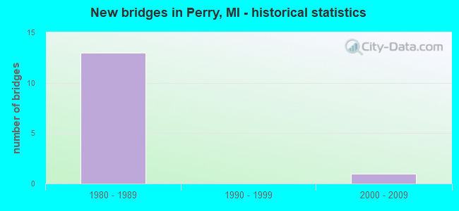
- New bridges - historical statistics
- 131980-1989
- 12000-2009


- Bridge Condition - Deck
- 25.0%Very good
- 25.0%Good
- 50.0%Satisfactory

- Bridge Condition - Superstructure
- 37.5%Very good
- 37.5%Good
- 25.0%Satisfactory

- Bridge Condition - Substructure
- 12.5%Very good
- 75.0%Good
- 12.5%Satisfactory
Find on map >> Show street view
Structure Number: 9723, Location: 2.6 MI N OF I-69 (Lat: 42.878747, Lng: -84.221667), Route carried "on" structure: State highway 52, Year Built: 2000, Status: Open, Structure Length: 2.35m (7.71ft), Average Daily Traffic: 10,212 (year 2007), Truck Traffic: 5%, Average Future Daily Traffic: 13,177 (year 2018), Design Load: HS 25 or greater, Features Intersected: LOOKING GLASS RIVER
Minimum Vertical Clearance: 30.48m (100.00ft), Kilometerpoint: 11.644, Lanes on structure: 2, Base Highway Network: Yes (Inventory Route: 55, Subroute: 6), Owner: State Highway Agency, Approaching Roadway Width: 12.8m (42.0ft), Material/Design: Prestressed concrete, Design/Construction: Box Beam or Girders - Single/Spread, Number Of Spans In Main Unit: 1, Length of Maximum Span: 22.6m (74.1ft), Curb-To-Curb Width: 13.2m (43.3ft), Out-to-Out Width: 14.2m (46.6ft)
Condition: Deck: Satisfactory, Superstructure: Very good, Substructure: Good, Channel: Satisfactory, Operating Rating: 62.5 metric tons, Method Used To Determine Operating Rating: Load Factor (LF) rating reported by rating factor (RF) method using MS18 loading, Inventory Rating: 21.4 metric tons, Method Used To Determine Inventory Rating: Load Factor (LF) rating reported by rating factor (RF) method using MS18 loading, Structural Evaluation: Somewhat better than minimum adequacy, Deck Geometry: Somewhat better than minimum adequacy, Waterway Adequacy: Equal to present desirable criteria, Approach Roadway Alignment: Equal to present desirable criteria, Designated Inspection Frequency: Every 24 months, Inspection Date: July 2021, Deck Structure Type: Concrete Cast-file-Place, Wearing Surface/Protective System: Wearing Surface: Epoxy Overlay, Deck Protection: Epoxy Coated Reinforcing
Find on map >> Show street view
Structure Number: 9759, Location: 1.6 MI E OF COLBY LAKE RD (Lat: 42.813217, Lng: -84.293403), Route carried "on" structure: Interstate 69, Year Built: 1989, Status: Open, Structure Length: 3.01m (9.88ft), Average Daily Traffic: 20,138 (year 2020), Truck Traffic: 15%, Average Future Daily Traffic: 22,263 (year 2040), Design Load: HS 25 or greater, Features Intersected: SHAFTSBURG RD
Minimum Vertical Clearance: 30.48m (100.00ft), Kilometerpoint: 6.071, Lanes on structure: 2, Lanes under structure: 2, Base Highway Network: Yes (Inventory Route: 55, Subroute: 8), Owner: State Highway Agency, Approaching Roadway Width: 7.3m (24.0ft), Skew: 1 degrees, Material/Design: Prestressed concrete, Design/Construction: Stringer/Multi-beam, Number Of Spans In Main Unit: 1, Length of Maximum Span: 30.1m (98.8ft), Curb-To-Curb Width: 13.4m (44.0ft), Out-to-Out Width: 14.4m (47.2ft)
Condition: Deck: Satisfactory, Superstructure: Good, Substructure: Good, Operating Rating: 61.4 metric tons, Method Used To Determine Operating Rating: Load Factor (LF), Inventory Rating: 44.5 metric tons, Method Used To Determine Inventory Rating: Load Factor (LF), Structural Evaluation: Better than present minimum criteria, Deck Geometry: Superior to present desirable criteria, Underclear: Somewhat better than minimum adequacy, Approach Roadway Alignment: Equal to present desirable criteria, Designated Inspection Frequency: Every 24 months, Inspection Date: June 2021, Deck Structure Type: Concrete Cast-file-Place, Wearing Surface/Protective System: Wearing Surface: Epoxy Overlay, Deck Protection: Epoxy Coated Reinforcing
Find on map >> Show street view
Structure Number: 976, Location: 2.5 MI WEST OF PERRY (Lat: 42.819600, Lng: -84.270642), Route carried "on" structure: Interstate 69, Year Built: 1988, Status: Open, Structure Length: 5.18m (16.99ft), Average Daily Traffic: 20,138 (year 2020), Truck Traffic: 15%, Average Future Daily Traffic: 22,263 (year 2040), Design Load: HS 25 or greater, Features Intersected: BATH RD
Minimum Vertical Clearance: 30.48m (100.00ft), Kilometerpoint: 8.087, Lanes on structure: 2, Lanes under structure: 4, Base Highway Network: Yes (Inventory Route: 55, Subroute: 8), Owner: State Highway Agency, Approaching Roadway Width: 14.6m (47.9ft), Skew: 4 degrees, Material/Design: Prestressed concrete, Design/Construction: Stringer/Multi-beam, Number Of Spans In Main Unit: 3, Length of Maximum Span: 24.7m (81.0ft), Curb-To-Curb Width: 13.7m (44.9ft), Out-to-Out Width: 14.7m (48.2ft)
Condition: Deck: Good, Superstructure: Satisfactory, Substructure: Satisfactory, Operating Rating: 51.2 metric tons, Method Used To Determine Operating Rating: Load and Resistance Factor Rating (LRFR) rating reported by rating factor(RF) method using HL-93 loadings, Inventory Rating: 39.5 metric tons, Method Used To Determine Inventory Rating: Load and Resistance Factor Rating (LRFR) rating reported by rating factor(RF) method using HL-93 loadings, Structural Evaluation: Equal to present minimum criteria, Deck Geometry: Superior to present desirable criteria, Underclear: Equal to present minimum criteria, Approach Roadway Alignment: Equal to present desirable criteria, Designated Inspection Frequency: Every 24 months, Inspection Date: July 2021, Deck Structure Type: Concrete Cast-file-Place, Wearing Surface/Protective System: Wearing Surface: Epoxy Overlay, Membrane: Epoxy, Deck Protection: Epoxy Coated Reinforcing
Find on map >> Show street view
Structure Number: 9762, Location: 0.5 M WEST OF PERRY (Lat: 42.834025, Lng: -84.238678), Route carried "on" structure: County highway 53, Year Built: 1989, Status: Open, Structure Length: 12.95m (42.49ft), Average Daily Traffic: 25,000 (year 1995), Truck Traffic: 21%, Average Future Daily Traffic: 28,750 (year 2015), Design Load: HS 25 or greater, Features Intersected: I-69, Facility Carried by Structure: BRITTON RD
Minimum Vertical Clearance: 30.48m (100.00ft), Kilometerpoint: 10.984, Lanes on structure: 2, Lanes under structure: 4, Owner: State Highway Agency, Approaching Roadway Width: 12.2m (40.0ft), Skew: 4 degrees, Material/Design: Steel continuous, Design/Construction: Stringer/Multi-beam, Number Of Spans In Main Unit: 2, Number Of Approach Spans: 2, Length of Maximum Span: 48.0m (157.5ft), Curb-To-Curb Width: 13.4m (44.0ft), Out-to-Out Width: 14.4m (47.2ft)
Condition: Deck: Good, Superstructure: Satisfactory, Substructure: Good, Operating Rating: 73.2 metric tons, Method Used To Determine Operating Rating: Load Factor (LF) rating reported by rating factor (RF) method using MS18 loading, Inventory Rating: 43.7 metric tons, Method Used To Determine Inventory Rating: Load Factor (LF) rating reported by rating factor (RF) method using MS18 loading, Structural Evaluation: Equal to present minimum criteria, Deck Geometry: Equal to present minimum criteria, Underclear: Equal to present minimum criteria, Approach Roadway Alignment: Equal to present desirable criteria, Designated Inspection Frequency: Every 24 months, Inspection Date: July 2021, Deck Structure Type: Concrete Cast-file-Place, Wearing Surface/Protective System: Wearing Surface: Epoxy Overlay, Deck Protection: Epoxy Coated Reinforcing
Find on map >> Show street view
Structure Number: 9763, Location: 0.5 MI N OF PERRY (Lat: 42.839667, Lng: -84.219722), Route carried "on" structure: State highway 52, Year Built: 1989, Status: Open, Structure Length: 8.41m (27.59ft), Average Daily Traffic: 15,425 (year 2020), Truck Traffic: 3%, Average Future Daily Traffic: 17,050 (year 2040), Design Load: HS 25 or greater, Features Intersected: I-69
Minimum Vertical Clearance: 30.48m (100.00ft), Kilometerpoint: 7.302, Lanes on structure: 3, Lanes under structure: 4, Base Highway Network: Yes (Inventory Route: 55, Subroute: 6), Owner: State Highway Agency, Approaching Roadway Width: 14.6m (47.9ft), Material/Design: Steel continuous, Design/Construction: Stringer/Multi-beam, Number Of Spans In Main Unit: 2, Length of Maximum Span: 41.5m (136.2ft), Curb-To-Curb Width: 17.1m (56.1ft), Out-to-Out Width: 18.0m (59.1ft)
Condition: Deck: Satisfactory, Superstructure: Good, Substructure: Good, Operating Rating: 78.7 metric tons, Method Used To Determine Operating Rating: Load Factor (LF) rating reported by rating factor (RF) method using MS18 loading, Inventory Rating: 47.0 metric tons, Method Used To Determine Inventory Rating: Load Factor (LF) rating reported by rating factor (RF) method using MS18 loading, Structural Evaluation: Better than present minimum criteria, Deck Geometry: Superior to present desirable criteria, Underclear: Equal to present minimum criteria, Approach Roadway Alignment: Equal to present desirable criteria, Designated Inspection Frequency: Every 24 months, Inspection Date: June 2021, Deck Structure Type: Concrete Cast-file-Place, Wearing Surface/Protective System: Wearing Surface: Epoxy Overlay, Deck Protection: Epoxy Coated Reinforcing
Find on map >> Show street view
Structure Number: 9766, Location: 1.6 MI E OF COLBY LAKE RD (Lat: 42.813561, Lng: -84.293411), Route carried "on" structure: Interstate 69, Year Built: 1989, Status: Open, Structure Length: 2.92m (9.58ft), Average Daily Traffic: 20,138 (year 2020), Truck Traffic: 15%, Average Future Daily Traffic: 22,263 (year 2040), Design Load: HS 25 or greater, Features Intersected: SHAFTSBURG RD
Minimum Vertical Clearance: 30.48m (100.00ft), Kilometerpoint: 6.072, Lanes on structure: 2, Lanes under structure: 2, Base Highway Network: Yes (Inventory Route: 55, Subroute: 9), Owner: State Highway Agency, Approaching Roadway Width: 12.8m (42.0ft), Skew: 1 degrees, Material/Design: Prestressed concrete, Design/Construction: Stringer/Multi-beam, Number Of Spans In Main Unit: 1, Length of Maximum Span: 28.0m (91.9ft), Curb-To-Curb Width: 13.4m (44.0ft), Out-to-Out Width: 14.4m (47.2ft)
Condition: Deck: Satisfactory, Superstructure: Good, Substructure: Good, Operating Rating: 80.4 metric tons, Method Used To Determine Operating Rating: Load Factor (LF) rating reported by rating factor (RF) method using MS18 loading, Inventory Rating: 37.3 metric tons, Method Used To Determine Inventory Rating: Load Factor (LF) rating reported by rating factor (RF) method using MS18 loading, Structural Evaluation: Better than present minimum criteria, Deck Geometry: Superior to present desirable criteria, Underclear: Equal to present minimum criteria, Approach Roadway Alignment: Equal to present desirable criteria, Designated Inspection Frequency: Every 24 months, Inspection Date: June 2021, Deck Structure Type: Concrete Cast-file-Place, Wearing Surface/Protective System: Wearing Surface: Epoxy Overlay, Deck Protection: Epoxy Coated Reinforcing
Find on map >> Show street view
Structure Number: 9829, Location: 4.5 MI SE OF LAINGSBURG (Lat: 42.873872, Lng: -84.265903), Route carried "on" structure: County highway , Year Built: 1984, Status: Open, Structure Length: 2.68m (8.79ft), Average Daily Traffic: 210 (year 1992), Truck Traffic: 5%, Average Future Daily Traffic: 463 (year 2032), Design Load: HS 20+Mod, Features Intersected: LOOKINGGLASS RIVER, Facility Carried by Structure: BEARDSLEE RD
Minimum Vertical Clearance: 30.48m (100.00ft), Kilometerpoint: 4.770, Lanes on structure: 2, Owner: County Highway Agency, Approaching Roadway Width: 9.1m (29.9ft), Material/Design: Prestressed concrete, Design/Construction: Box Beam or Girders - Multiple, Number Of Spans In Main Unit: 1, Length of Maximum Span: 25.6m (84.0ft), Curb-To-Curb Width: 9.1m (29.9ft), Out-to-Out Width: 9.5m (31.2ft)
Condition: Deck: Very good, Superstructure: Very good, Substructure: Very good, Channel: Satisfactory, Operating Rating: 65.1 metric tons, Method Used To Determine Operating Rating: Load Factor (LF) rating reported by rating factor (RF) method using MS18 loading, Inventory Rating: 38.9 metric tons, Method Used To Determine Inventory Rating: Load Factor (LF) rating reported by rating factor (RF) method using MS18 loading, Structural Evaluation: Equal to present desirable criteria, Deck Geometry: Equal to present minimum criteria, Waterway Adequacy: Equal to present desirable criteria, Approach Roadway Alignment: Equal to present desirable criteria, Designated Inspection Frequency: Every 24 months, Inspection Date: March 2022, Deck Structure Type: Concrete Precast Panels, Wearing Surface/Protective System: Wearing Surface: Bituminous, Membrane: Preformed Fabric
Find on map >> Show street view
Structure Number: 9859, Location: 1.5 MI SE OF SHAFTSBURG (Lat: 42.790825, Lng: -84.267025), Route carried "on" structure: County highway , Year Built: 1983, Status: Open, Structure Length: 2.13m (6.99ft), Average Daily Traffic: 523 (year 2015), Truck Traffic: 5%, Average Future Daily Traffic: 778 (year 2035), Design Load: HS 20, Features Intersected: S BR LOOKINGGLASS RIVER, Facility Carried by Structure: BEARDSLEE RD
Minimum Vertical Clearance: 30.48m (100.00ft), Kilometerpoint: 1.910, Lanes on structure: 2, Owner: County Highway Agency, Approaching Roadway Width: 9.4m (30.8ft), Material/Design: Prestressed concrete, Design/Construction: Box Beam or Girders - Multiple, Number Of Spans In Main Unit: 1, Length of Maximum Span: 20.9m (68.6ft), Curb-To-Curb Width: 8.9m (29.2ft), Out-to-Out Width: 9.5m (31.2ft)
Condition: Deck: Very good, Superstructure: Very good, Substructure: Good, Channel: Satisfactory, Operating Rating: 65.1 metric tons, Method Used To Determine Operating Rating: Load Factor (LF) rating reported by rating factor (RF) method using MS18 loading, Inventory Rating: 39.2 metric tons, Method Used To Determine Inventory Rating: Load Factor (LF) rating reported by rating factor (RF) method using MS18 loading, Structural Evaluation: Better than present minimum criteria, Deck Geometry: Somewhat better than minimum adequacy, Waterway Adequacy: Equal to present desirable criteria, Approach Roadway Alignment: Equal to present desirable criteria, Designated Inspection Frequency: Every 24 months, Inspection Date: May 2020, Deck Structure Type: Concrete Precast Panels, Wearing Surface/Protective System: Wearing Surface: Bituminous, Membrane: Preformed Fabric
Find on map >> Show street view
Structure Number: 9759, Location: 1.6 MI E OF COLBY LAKE RD (Lat: 42.813217, Lng: -84.293403), Route carried "under" structure: County highway 1999, Year Built: 1989, Structure Length: 0. m, Average Daily Traffic: 1,050 (year 1993), Truck Traffic: 2%, Features Intersected: SHAFTSBURG RD, Facility Carried by Structure: I-69 EB
Minimum Vertical Clearance: 4.67m (15.32ft), Kilometerpoint: 4.133, Lanes on structure: 2, Lanes under structure: 2, Material/Design: Prestressed concrete, Design/Construction: Stringer/Multi-beam, Length of Maximum Span: 30.1m (98.8ft)
Find on map >> Show street view
Structure Number: 976, Location: 2.5 MI WEST OF PERRY (Lat: 42.819600, Lng: -84.270642), Route carried "under" structure: County highway 7612, Year Built: 1988, Structure Length: 0. m, Average Daily Traffic: 2,132 (year 1989), Truck Traffic: 2%, Features Intersected: BATH RD, Facility Carried by Structure: I-69 EB
Minimum Vertical Clearance: 4.78m (15.68ft), Kilometerpoint: 8.465, Lanes on structure: 2, Lanes under structure: 4, Material/Design: Prestressed concrete, Design/Construction: Stringer/Multi-beam, Length of Maximum Span: 24.7m (81.0ft)
Find on map >> Show street view
Structure Number: 9761, Location: 2.5 MILES W OF PERRY (Lat: 42.819597, Lng: -84.271303), Route carried "under" structure: County highway 7612, Year Built: 1988, Structure Length: 0. m, Average Daily Traffic: 2,132 (year 1989), Truck Traffic: 2%, Features Intersected: BATH RD, Facility Carried by Structure: I-69 WB
Minimum Vertical Clearance: 4.75m (15.58ft), Kilometerpoint: 8.411, Lanes on structure: 2, Lanes under structure: 2, Material/Design: Prestressed concrete, Design/Construction: Stringer/Multi-beam, Length of Maximum Span: 24.7m (81.0ft)
Find on map >> Show street view
Structure Number: 9762, Location: 0.5 M WEST OF PERRY (Lat: 42.834025, Lng: -84.238678), Route carried "under" structure: Interstate 69, Year Built: 1989, Structure Length: 0. m, Average Daily Traffic: 40,275 (year 2020), Truck Traffic: 15%, Features Intersected: I-69, Facility Carried by Structure: BRITTON RD
Minimum Vertical Clearance: 5.72m (18.77ft), Kilometerpoint: 11.224, Lanes on structure: 2, Lanes under structure: 4, Material/Design: Steel continuous, Design/Construction: Stringer/Multi-beam, Length of Maximum Span: 48.0m (157.5ft)
Find on map >> Show street view
Structure Number: 9763, Location: 0.5 MI N OF PERRY (Lat: 42.839667, Lng: -84.219722), Route carried "under" structure: Interstate 69, Year Built: 1989, Structure Length: 0. m, Average Daily Traffic: 40,275 (year 2020), Truck Traffic: 15%, Features Intersected: I-69, Facility Carried by Structure: M-52
Minimum Vertical Clearance: 5.36m (17.59ft), Kilometerpoint: 12.940, Lanes on structure: 3, Lanes under structure: 4, Material/Design: Steel continuous, Design/Construction: Stringer/Multi-beam, Length of Maximum Span: 41.5m (136.2ft)
Find on map >> Show street view
Structure Number: 9766, Location: 1.6 MI E OF COLBY LAKE RD (Lat: 42.813561, Lng: -84.293411), Route carried "under" structure: County highway 19, Year Built: 1989, Structure Length: 0. m, Average Daily Traffic: 1,050 (year 1993), Truck Traffic: 2%, Features Intersected: SHAFTSBURG RD, Facility Carried by Structure: I-69 WB
Minimum Vertical Clearance: 4.52m (14.83ft), Kilometerpoint: 4.172, Lanes on structure: 2, Lanes under structure: 2, Material/Design: Prestressed concrete, Design/Construction: Stringer/Multi-beam, Length of Maximum Span: 28.0m (91.9ft)