Bridge Statistics for Peotone, Illinois (IL)
Condition, Traffic, Stress, Structural Evaluation, Project Costs
- National Bridge Inventory (NBI) Statistics
- 35Number of bridges
- 262ft / 79.6mTotal length
- $1,489,000Total costs
- 174,725Total average daily traffic
- 37,887Total average daily truck traffic
- National Bridge Inventory (NBI) Registered Bridges for Peotone
- No street view available for this location
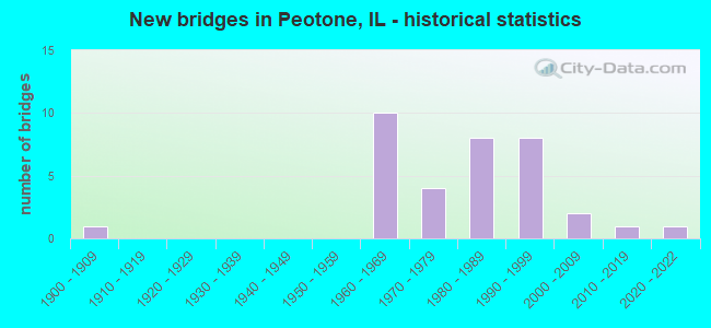
- New bridges - historical statistics
- 11900-1909
- 101960-1969
- 41970-1979
- 81980-1989
- 81990-1999
- 22000-2009
- 12010-2019
- 12020-2022

- Reconstructed bridges - Historical Statistics
- 11980-1989
- 21990-1999
- 12000-2009


- Bridge Condition - Deck
- 10.7%Very good
- 21.4%Good
- 42.9%Satisfactory
- 21.4%Fair
- 3.6%Poor

- Bridge Condition - Superstructure
- 14.3%Very good
- 21.4%Good
- 32.1%Satisfactory
- 28.6%Fair
- 3.6%Poor

- Bridge Condition - Substructure
- 10.7%Very good
- 39.3%Good
- 35.7%Satisfactory
- 14.3%Fair

- Bridge Condition - Channel
- 3.4%Excellent
- 13.8%Very good
- 20.7%Good
- 34.5%Satisfactory
- 27.6%Fair

- Bridge Condition - Culverts
- 40.0%Very good
- 40.0%Satisfactory
- 20.0%Fair
Find on map >> Show street view
Structure Number: 463018, Location: 3.62 MI NE MANTENO (Lat: 41.281819, Lng: -87.781439), Route carried "on" structure: County highway , Year Built: 1966, Status: Open, Structure Length: 1.40m (4.59ft), Average Daily Traffic: 625 (year 2021), Truck Traffic: 14%, Average Future Daily Traffic: 973 (year 2032), Design Load: HS 15, Features Intersected: MARSHALL SL, Facility Carried by Structure: CH 51
Minimum Vertical Clearance: 30+ m (98+ ft), Kilometerpoint: 1.561, Lanes on structure: 2, Owner: County Highway Agency, Approaching Roadway Width: 5.5m (18.0ft), Material/Design: Prestressed concrete, Design/Construction: Box Beam or Girders - Multiple, Number Of Spans In Main Unit: 1, Length of Maximum Span: 13.1m (43.0ft), Curb-To-Curb Width: 7.3m (24.0ft), Out-to-Out Width: 8.7m (28.5ft)
Condition: Deck: Fair, Superstructure: Fair, Substructure: Good, Channel: Satisfactory, Operating Rating: 44.7 metric tons, Method Used To Determine Operating Rating: Load Factor (LF) rating reported by rating factor (RF) method using MS18 loading, Inventory Rating: 26.9 metric tons, Method Used To Determine Inventory Rating: Load Factor (LF) rating reported by rating factor (RF) method using MS18 loading, Structural Evaluation: Somewhat better than minimum adequacy, Deck Geometry: Meets minimum limits, Waterway Adequacy: Equal to present minimum criteria, Approach Roadway Alignment: Better than present minimum criteria, Designated Inspection Frequency: Every 24 months, Inspection Date: April 2020, Deck Structure Type: Concrete Precast Panels, Wearing Surface/Protective System: Wearing Surface: Bituminous
Find on map >> Show street view
Structure Number: 463232, Location: 3.2 MI NE MANTENO (Lat: 41.295711, Lng: -87.794750), Route carried "on" structure: County highway , Year Built: 1965, Status: Open, Structure Length: 1.69m (5.54ft), Average Daily Traffic: 1,900 (year 2021), Truck Traffic: 20%, Average Future Daily Traffic: 1,676 (year 2032), Design Load: HS 15, Features Intersected: BLACK WALNUT CR, Facility Carried by Structure: CH 16
Minimum Vertical Clearance: 30+ m (98+ ft), Kilometerpoint: 1.239, Lanes on structure: 2, Owner: County Highway Agency, Approaching Roadway Width: 6.1m (20.0ft), Material/Design: Prestressed concrete, Design/Construction: Box Beam or Girders - Multiple, Number Of Spans In Main Unit: 1, Length of Maximum Span: 16.5m (54.1ft), Curb-To-Curb Width: 7.3m (24.0ft), Out-to-Out Width: 8.8m (28.9ft)
Condition: Deck: Poor, Superstructure: Poor, Substructure: Satisfactory, Channel: Satisfactory, Operating Rating: 39.9 metric tons, Method Used To Determine Operating Rating: Load Factor (LF) rating reported by rating factor (RF) method using MS18 loading, Inventory Rating: 21.1 metric tons, Method Used To Determine Inventory Rating: Load Factor (LF) rating reported by rating factor (RF) method using MS18 loading, Structural Evaluation: Meets minimum limits, Deck Geometry: Meets minimum limits, Waterway Adequacy: Equal to present minimum criteria, Approach Roadway Alignment: Equal to present desirable criteria, Designated Inspection Frequency: Every 24 months, Inspection Date: April 2020, Deck Structure Type: Concrete Precast Panels, Wearing Surface/Protective System: Wearing Surface: Bituminous
Find on map >> Show street view
Structure Number: 463233, Location: 4.7 MI NE MANTENO (Lat: 41.296100, Lng: -87.751375), Route carried "on" structure: County highway , Year Built: 1971, Status: Open, Structure Length: 0.98m (3.22ft), Average Daily Traffic: 1,900 (year 2021), Truck Traffic: 20%, Average Future Daily Traffic: 1,676 (year 2032), Design Load: HS 15, Features Intersected: ROCK CR, Facility Carried by Structure: CH 16
Minimum Vertical Clearance: 30+ m (98+ ft), Kilometerpoint: 4.860, Lanes on structure: 2, Owner: County Highway Agency, Approaching Roadway Width: 5.5m (18.0ft), Material/Design: Concrete, Design/Construction: Channel Beam, Number Of Spans In Main Unit: 1, Length of Maximum Span: 8.8m (28.9ft), Curb-To-Curb Width: 7.4m (24.3ft), Out-to-Out Width: 8.2m (26.9ft)
Condition: Deck: Satisfactory, Superstructure: Satisfactory, Substructure: Satisfactory, Channel: Fair, Operating Rating: 49.6 metric tons, Method Used To Determine Operating Rating: Load Factor (LF) rating reported by rating factor (RF) method using MS18 loading, Inventory Rating: 29.8 metric tons, Method Used To Determine Inventory Rating: Load Factor (LF) rating reported by rating factor (RF) method using MS18 loading, Structural Evaluation: Equal to present minimum criteria, Deck Geometry: Meets minimum limits, Waterway Adequacy: Equal to present minimum criteria, Approach Roadway Alignment: Equal to present desirable criteria, Designated Inspection Frequency: Every 24 months, Inspection Date: April 2020, Deck Structure Type: Concrete Precast Panels, Wearing Surface/Protective System: Wearing Surface: Bituminous
Find on map >> Show street view
Structure Number: 463461, Location: 6 M NE MANTENO (Lat: 41.283439, Lng: -87.761711), Route carried "on" structure: County highway , Year Built: 1993, Status: Open, Structure Length: 2.52m (8.27ft), Average Daily Traffic: 50 (year 2020), Average Future Daily Traffic: 54 (year 2032), Design Load: HS 20, Features Intersected: MARSHALL SLOUGH, Facility Carried by Structure: TR 182
Minimum Vertical Clearance: 30+ m (98+ ft), Kilometerpoint: 1.384, Lanes on structure: 2, Owner: Town or Township Highway Agency, Approaching Roadway Width: 5.5m (18.0ft), Skew: 1 degrees, Material/Design: Prestressed concrete, Design/Construction: Box Beam or Girders - Multiple, Number Of Spans In Main Unit: 3, Length of Maximum Span: 12.2m (40.0ft), Curb-To-Curb Width: 8.5m (27.9ft), Out-to-Out Width: 8.5m (27.9ft)
Condition: Deck: Good, Superstructure: Good, Substructure: Good, Channel: Fair, Operating Rating: 44.1 metric tons, Method Used To Determine Operating Rating: Assigned rating based on Load Factor Design (LFD) reported by rating factor (RF) using MS18 loading, Inventory Rating: 32.4 metric tons, Method Used To Determine Inventory Rating: Assigned rating based on Load Factor Design (LFD) reported by rating factor (RF) using MS18 loading, Structural Evaluation: Better than present minimum criteria, Deck Geometry: Better than present minimum criteria, Waterway Adequacy: Equal to present minimum criteria, Approach Roadway Alignment: Equal to present desirable criteria, Designated Inspection Frequency: Every 48 months, Inspection Date: April 2018, Deck Structure Type: Concrete Precast Panels
Find on map >> Show street view
Structure Number: 990038, Location: 12.8 M S OF US 30 (Lat: 41.328494, Lng: -87.818964), Route carried "on" structure: Interstate 57, Year Built: 1967, Status: Open, Structure Length: 5.29m (17.36ft), Average Daily Traffic: 17,100 (year 2021), Truck Traffic: 23%, Average Future Daily Traffic: 20,517 (year 2032), Design Load: HS 20+Mod, Features Intersected: ABANDONED RR
Minimum Vertical Clearance: 30+ m (98+ ft), Kilometerpoint: 526.965, Lanes on structure: 2, Base Highway Network: Yes, Owner: State Highway Agency, Approaching Roadway Width: 13.4m (44.0ft), Skew: 2 degrees, Material/Design: Steel continuous, Design/Construction: Stringer/Multi-beam, Number Of Spans In Main Unit: 3, Length of Maximum Span: 19.1m (62.7ft), Curb-To-Curb Width: 11.0m (36.1ft), Out-to-Out Width: 12.0m (39.4ft)
Condition: Deck: Fair, Superstructure: Fair, Substructure: Satisfactory, Operating Rating: 60.9 metric tons, Method Used To Determine Operating Rating: Load Factor (LF) rating reported by rating factor (RF) method using MS18 loading, Inventory Rating: 36.6 metric tons, Method Used To Determine Inventory Rating: Load Factor (LF) rating reported by rating factor (RF) method using MS18 loading, Structural Evaluation: Somewhat better than minimum adequacy, Deck Geometry: Somewhat better than minimum adequacy, Approach Roadway Alignment: Equal to present desirable criteria, Designated Inspection Frequency: Every 24 months, Inspection Date: August 2020, Deck Structure Type: Concrete Cast-file-Place, Wearing Surface/Protective System: Wearing Surface: Latex Concrete, Membrane: Built-up
Find on map >> Show street view
Structure Number: 990039, Location: 12.8 M S OF US 30 (Lat: 41.328642, Lng: -87.818936), Route carried "on" structure: Interstate 57, Year Built: 1967, Status: Open, Structure Length: 5.29m (17.36ft), Average Daily Traffic: 17,100 (year 2021), Truck Traffic: 23%, Average Future Daily Traffic: 20,517 (year 2032), Design Load: HS 20+Mod, Features Intersected: ABANDONED RR
Minimum Vertical Clearance: 30+ m (98+ ft), Kilometerpoint: 526.981, Lanes on structure: 2, Base Highway Network: Yes, Owner: State Highway Agency, Approaching Roadway Width: 13.4m (44.0ft), Skew: 2 degrees, Material/Design: Steel continuous, Design/Construction: Stringer/Multi-beam, Number Of Spans In Main Unit: 3, Length of Maximum Span: 19.1m (62.7ft), Curb-To-Curb Width: 9.9m (32.5ft), Out-to-Out Width: 11.0m (36.1ft)
Condition: Deck: Fair, Superstructure: Fair, Substructure: Satisfactory, Operating Rating: 67.1 metric tons, Method Used To Determine Operating Rating: Load Factor (LF) rating reported by rating factor (RF) method using MS18 loading, Inventory Rating: 40.2 metric tons, Method Used To Determine Inventory Rating: Load Factor (LF) rating reported by rating factor (RF) method using MS18 loading, Structural Evaluation: Somewhat better than minimum adequacy, Deck Geometry: High priority of replacement, Approach Roadway Alignment: Equal to present desirable criteria, Designated Inspection Frequency: Every 24 months, Inspection Date: August 2020, Deck Structure Type: Concrete Cast-file-Place, Wearing Surface/Protective System: Wearing Surface: Latex Concrete, Membrane: Built-up
Find on map >> Show street view
Structure Number: 990161, Location: 13.2 M S OF US 30 (Lat: 41.324464, Lng: -87.820272), Route carried "on" structure: Other road , Year Built: 1967, Year Reconstructed: 2001, Status: Open, Structure Length: 7.03m (23.06ft), Average Daily Traffic: 5,600 (year 2019), Truck Traffic: 29%, Average Future Daily Traffic: 5,565 (year 2032), Design Load: HS 20, Features Intersected: I- 57, Facility Carried by Structure: WILMINGTON RD
Minimum Vertical Clearance: 30+ m (98+ ft), Kilometerpoint: 36.563, Lanes on structure: 2, Lanes under structure: 4, Base Highway Network: Yes, Owner: State Highway Agency, Approaching Roadway Width: 9.6m (31.5ft), Material/Design: Steel continuous, Design/Construction: Stringer/Multi-beam, Number Of Spans In Main Unit: 4, Length of Maximum Span: 20.7m (67.9ft), Curb-To-Curb Width: 9.6m (31.5ft), Out-to-Out Width: 10.6m (34.8ft)
Condition: Deck: Satisfactory, Superstructure: Fair, Substructure: Good, Operating Rating: 89.1 metric tons, Method Used To Determine Operating Rating: Load Factor (LF) rating reported by rating factor (RF) method using MS18 loading, Inventory Rating: 58.3 metric tons, Method Used To Determine Inventory Rating: Load Factor (LF) rating reported by rating factor (RF) method using MS18 loading, Structural Evaluation: Somewhat better than minimum adequacy, Deck Geometry: Meets minimum limits, Underclear: High priority of corrective action, Approach Roadway Alignment: Equal to present desirable criteria, Length Of Structure Improvement: 6.95m (22.80ft), Designated Inspection Frequency: Every 24 months, Inspection Date: November 2020, Bridge Improvement Cost: $155,000, Roadway Improvement Cost: $16,000, Total Project Cost: $186,000, Deck Structure Type: Concrete Cast-file-Place, Wearing Surface/Protective System: Deck Protection: Epoxy Coated Reinforcing
Find on map >> Show street view
Structure Number: 990162, Location: 11.2 M S OF US 30 (Lat: 41.353656, Lng: -87.813325), Route carried "on" structure: County highway , Year Built: 1967, Status: Open, Structure Length: 8.65m (28.38ft), Average Daily Traffic: 1,000 (year 2019), Truck Traffic: 4%, Average Future Daily Traffic: 2,481 (year 2032), Design Load: HS 20+Mod, Features Intersected: I- 57, Facility Carried by Structure: JOLIET RD (PEOTONE
Minimum Vertical Clearance: 30+ m (98+ ft), Kilometerpoint: 5.761, Lanes on structure: 2, Lanes under structure: 4, Owner: State Highway Agency, Approaching Roadway Width: 8.5m (27.9ft), Skew: 3 degrees, Material/Design: Steel continuous, Design/Construction: Stringer/Multi-beam, Number Of Spans In Main Unit: 4, Length of Maximum Span: 26.2m (86.0ft), Curb-To-Curb Width: 9.3m (30.5ft), Out-to-Out Width: 10.3m (33.8ft)
Condition: Deck: Satisfactory, Superstructure: Fair, Substructure: Good, Operating Rating: 57.0 metric tons, Method Used To Determine Operating Rating: Load Factor (LF) rating reported by rating factor (RF) method using MS18 loading, Inventory Rating: 34.0 metric tons, Method Used To Determine Inventory Rating: Load Factor (LF) rating reported by rating factor (RF) method using MS18 loading, Structural Evaluation: Somewhat better than minimum adequacy, Deck Geometry: Equal to present minimum criteria, Underclear: High priority of corrective action, Approach Roadway Alignment: Equal to present desirable criteria, Length Of Structure Improvement: 8.66m (28.41ft), Designated Inspection Frequency: Every 24 months, Inspection Date: November 2020, Bridge Improvement Cost: $528,000, Roadway Improvement Cost: $53,000, Total Project Cost: $792,000, Deck Structure Type: Concrete Cast-file-Place, Wearing Surface/Protective System: Wearing Surface: Latex Concrete
Find on map >> Show street view
Structure Number: 992001, Location: 12.5 M S OF US 30 (Lat: 41.334019, Lng: -87.817967), Route carried "on" structure: Interstate 57, Year Built: 1967, Status: Open, Structure Length: 1.45m (4.76ft), Average Daily Traffic: 34,200 (year 2021), Truck Traffic: 23%, Average Future Daily Traffic: 41,035 (year 2032), Design Load: HS 20+Mod, Features Intersected: ROCK CREEK
Minimum Vertical Clearance: 30+ m (98+ ft), Kilometerpoint: 527.577, Lanes on structure: 4, Base Highway Network: Yes, Owner: State Highway Agency, Approaching Roadway Width: 24.4m (80.1ft), Skew: 13 degrees, Material/Design: Concrete continuous, Design/Construction: Culvert, Number Of Spans In Main Unit: 3, Length of Maximum Span: 3.5m (11.5ft)
Condition: Channel: Fair, Culverts: Satisfactory, Operating Rating: 53.1 metric tons, Method Used To Determine Operating Rating: Load Factor (LF) rating reported by rating factor (RF) method using MS18 loading, Inventory Rating: 21.7 metric tons, Method Used To Determine Inventory Rating: Load Factor (LF) rating reported by rating factor (RF) method using MS18 loading, Structural Evaluation: Somewhat better than minimum adequacy, Waterway Adequacy: Equal to present minimum criteria, Approach Roadway Alignment: Equal to present desirable criteria, Designated Inspection Frequency: Every 24 months, Inspection Date: December 2020
Find on map >> Show street view
Structure Number: 993091, Location: 0.5 MI SO IL 50 (Lat: 41.321069, Lng: -87.785075), Route carried "on" structure: County highway , Year Built: 1962, Year Reconstructed: 2006, Status: Open, Structure Length: 1.48m (4.86ft), Average Daily Traffic: 1,600 (year 2019), Truck Traffic: 31%, Average Future Daily Traffic: 1,743 (year 2032), Design Load: HS 20, Features Intersected: BLACK WALNUT CREEK, Facility Carried by Structure: Drecksler Road
Minimum Vertical Clearance: 30+ m (98+ ft), Kilometerpoint: 1.014, Lanes on structure: 2, Owner: County Highway Agency, Approaching Roadway Width: 12.2m (40.0ft), Skew: 1 degrees, Material/Design: Steel, Design/Construction: Stringer/Multi-beam, Number Of Spans In Main Unit: 1, Length of Maximum Span: 14.2m (46.6ft), Curb-To-Curb Width: 12.2m (40.0ft), Out-to-Out Width: 13.2m (43.3ft)
Condition: Deck: Good, Superstructure: Very good, Substructure: Good, Channel: Excellent, Operating Rating: 96.6 metric tons, Method Used To Determine Operating Rating: Load Factor (LF) rating reported by rating factor (RF) method using MS18 loading, Inventory Rating: 57.7 metric tons, Method Used To Determine Inventory Rating: Load Factor (LF) rating reported by rating factor (RF) method using MS18 loading, Structural Evaluation: Better than present minimum criteria, Deck Geometry: Better than present minimum criteria, Waterway Adequacy: Equal to present desirable criteria, Approach Roadway Alignment: Equal to present desirable criteria, Length Of Structure Improvement: 2.19m (7.19ft), Designated Inspection Frequency: Every 48 months, Inspection Date: July 2018, Bridge Improvement Cost: $143,000, Roadway Improvement Cost: $14,000, Total Project Cost: $215,000, Deck Structure Type: Concrete Cast-file-Place, Wearing Surface/Protective System: Deck Protection: Epoxy Coated Reinforcing
Find on map >> Show street view
Structure Number: 993328, Location: 1.8M S OF BEACHER RD (Lat: 41.315131, Lng: -87.727361), Route carried "on" structure: County highway , Year Built: 2012, Status: Open, Structure Length: 1.10m (3.61ft), Average Daily Traffic: 950 (year 2019), Truck Traffic: 7%, Average Future Daily Traffic: 3,200 (year 2036), Design Load: HS 20, Features Intersected: S. BR ROCK CREEK, Facility Carried by Structure: WILL-CENTER RD, CH
Minimum Vertical Clearance: 30+ m (98+ ft), Kilometerpoint: 11.362, Lanes on structure: 2, Owner: County Highway Agency, Approaching Roadway Width: 12.2m (40.0ft), Material/Design: Concrete continuous, Design/Construction: Culvert, Number Of Spans In Main Unit: 3, Length of Maximum Span: 3.4m (11.2ft)
Condition: Channel: Satisfactory, Culverts: Satisfactory, Operating Rating: 43.7 metric tons, Method Used To Determine Operating Rating: Assigned rating based on Load Factor Design (LFD) reported by rating factor (RF) using MS18 loading, Inventory Rating: 32.4 metric tons, Method Used To Determine Inventory Rating: Assigned rating based on Load Factor Design (LFD) reported by rating factor (RF) using MS18 loading, Structural Evaluation: Equal to present minimum criteria, Waterway Adequacy: Superior to present desirable criteria, Approach Roadway Alignment: Equal to present desirable criteria, Designated Inspection Frequency: Every 24 months, Inspection Date: July 2020
Find on map >> Show street view
Structure Number: 99333, Location: 1.5M.E.OF IL-50 (Lat: 41.339700, Lng: -87.756208), Route carried "on" structure: Other road , Year Built: 1988, Year Reconstructed: 2003, Status: Open, Structure Length: 2.07m (6.79ft), Average Daily Traffic: 3,050 (year 2019), Truck Traffic: 13%, Average Future Daily Traffic: 3,420 (year 2032), Design Load: HS 20, Features Intersected: BLACK WALNUT CREEK, Facility Carried by Structure: PEOTONE-BEECHER RD
Minimum Vertical Clearance: 30+ m (98+ ft), Kilometerpoint: 2.446, Lanes on structure: 2, Base Highway Network: Yes, Owner: County Highway Agency, Approaching Roadway Width: 8.2m (26.9ft), Material/Design: Concrete, Design/Construction: Slab, Number Of Spans In Main Unit: 2, Length of Maximum Span: 10.4m (34.1ft), Curb-To-Curb Width: 13.7m (44.9ft), Out-to-Out Width: 14.0m (45.9ft)
Condition: Deck: Very good, Superstructure: Very good, Substructure: Fair, Channel: Very good, Operating Rating: 44.4 metric tons, Method Used To Determine Operating Rating: Load Factor (LF) rating reported by rating factor (RF) method using MS18 loading, Inventory Rating: 32.4 metric tons, Method Used To Determine Inventory Rating: Load Factor (LF) rating reported by rating factor (RF) method using MS18 loading, Structural Evaluation: Somewhat better than minimum adequacy, Deck Geometry: Superior to present desirable criteria, Waterway Adequacy: Equal to present desirable criteria, Approach Roadway Alignment: Equal to present desirable criteria, Length Of Structure Improvement: 2.07m (6.79ft), Designated Inspection Frequency: Every 24 months, Inspection Date: March 2021, Bridge Improvement Cost: $197,000, Roadway Improvement Cost: $20,000, Total Project Cost: $296,000, Deck Structure Type: Concrete Cast-file-Place, Wearing Surface/Protective System: Deck Protection: Other Coated Reinforcing
Find on map >> Show street view
Structure Number: 993339, Location: 0.8 M E WILTON RD (Lat: 41.340061, Lng: -87.712583), Route carried "on" structure: Other road , Year Built: 1990, Status: Open, Structure Length: 0.86m (2.82ft), Average Daily Traffic: 3,350 (year 2019), Truck Traffic: 9%, Average Future Daily Traffic: 3,554 (year 2032), Design Load: HS 20, Features Intersected: S.BR.ROCK CREEK, Facility Carried by Structure: PEOTONE/BEECHER RD
Minimum Vertical Clearance: 30+ m (98+ ft), Kilometerpoint: 6.099, Lanes on structure: 2, Base Highway Network: Yes, Owner: County Highway Agency, Approaching Roadway Width: 13.4m (44.0ft), Skew: 2 degrees, Material/Design: Concrete, Design/Construction: Culvert, Number Of Spans In Main Unit: 2, Length of Maximum Span: 4.3m (14.1ft)
Condition: Channel: Satisfactory, Culverts: Fair, Operating Rating: 44.4 metric tons, Method Used To Determine Operating Rating: Assigned rating based on Load Factor Design (LFD) reported by rating factor (RF) using MS18 loading, Inventory Rating: 32.4 metric tons, Method Used To Determine Inventory Rating: Assigned rating based on Load Factor Design (LFD) reported by rating factor (RF) using MS18 loading, Structural Evaluation: Somewhat better than minimum adequacy, Waterway Adequacy: Equal to present desirable criteria, Approach Roadway Alignment: Equal to present desirable criteria, Designated Inspection Frequency: Every 24 months, Inspection Date: July 2020
Find on map >> Show street view
Structure Number: 993344, Location: 0.5 MI W I-57 (Lat: 41.324331, Lng: -87.830931), Route carried "on" structure: Other road , Year Built: 1994, Status: Open, Structure Length: 3.07m (10.07ft), Average Daily Traffic: 5,600 (year 2019), Truck Traffic: 29%, Average Future Daily Traffic: 5,565 (year 2032), Design Load: HS 20, Features Intersected: ROCK CREEK, Facility Carried by Structure: WILMINGTON-PEOTNE
Minimum Vertical Clearance: 30+ m (98+ ft), Kilometerpoint: 35.662, Lanes on structure: 2, Base Highway Network: Yes, Owner: County Highway Agency, Approaching Roadway Width: 12.2m (40.0ft), Skew: 2 degrees, Material/Design: Concrete continuous, Design/Construction: Slab, Number Of Spans In Main Unit: 3, Length of Maximum Span: 11.3m (37.1ft), Curb-To-Curb Width: 12.2m (40.0ft), Out-to-Out Width: 13.0m (42.7ft)
Condition: Deck: Satisfactory, Superstructure: Satisfactory, Substructure: Satisfactory, Channel: Good, Operating Rating: 44.1 metric tons, Method Used To Determine Operating Rating: Assigned rating based on Load Factor Design (LFD) reported by rating factor (RF) using MS18 loading, Inventory Rating: 32.4 metric tons, Method Used To Determine Inventory Rating: Assigned rating based on Load Factor Design (LFD) reported by rating factor (RF) using MS18 loading, Structural Evaluation: Equal to present minimum criteria, Deck Geometry: Somewhat better than minimum adequacy, Waterway Adequacy: Equal to present desirable criteria, Approach Roadway Alignment: Equal to present desirable criteria, Designated Inspection Frequency: Every 24 months, Inspection Date: July 2020, Deck Structure Type: Concrete Cast-file-Place, Wearing Surface/Protective System: Deck Protection: Epoxy Coated Reinforcing
Find on map >> Show street view
Structure Number: 993345, Location: 1.9 MI E OF US 35,52 (Lat: 41.353242, Lng: -87.844381), Route carried "on" structure: County highway , Year Built: 1994, Status: Open, Structure Length: 2.47m (8.10ft), Average Daily Traffic: 1,750 (year 2021), Truck Traffic: 5%, Average Future Daily Traffic: 2,012 (year 2032), Design Load: HS 20, Features Intersected: SO BR FORKED CREEK, Facility Carried by Structure: NORTH PEOTONE RD
Minimum Vertical Clearance: 30+ m (98+ ft), Kilometerpoint: 3.154, Lanes on structure: 2, Owner: County Highway Agency, Approaching Roadway Width: 12.2m (40.0ft), Skew: 3 degrees, Material/Design: Steel, Design/Construction: Stringer/Multi-beam, Number Of Spans In Main Unit: 1, Length of Maximum Span: 23.8m (78.1ft), Curb-To-Curb Width: 12.2m (40.0ft), Out-to-Out Width: 13.0m (42.7ft)
Condition: Deck: Satisfactory, Superstructure: Good, Substructure: Good, Channel: Fair, Operating Rating: 44.1 metric tons, Method Used To Determine Operating Rating: Assigned rating based on Load Factor Design (LFD) reported by rating factor (RF) using MS18 loading, Inventory Rating: 32.4 metric tons, Method Used To Determine Inventory Rating: Assigned rating based on Load Factor Design (LFD) reported by rating factor (RF) using MS18 loading, Structural Evaluation: Better than present minimum criteria, Deck Geometry: Better than present minimum criteria, Waterway Adequacy: Equal to present desirable criteria, Approach Roadway Alignment: Equal to present desirable criteria, Designated Inspection Frequency: Every 48 months, Inspection Date: July 2018, Deck Structure Type: Concrete Cast-file-Place, Wearing Surface/Protective System: Deck Protection: Epoxy Coated Reinforcing
Find on map >> Show street view
Structure Number: 993346, Location: 0.1 MI N PEOTONE RD (Lat: 41.353542, Lng: -87.843617), Route carried "on" structure: Other road , Year Built: 1994, Status: Open, Structure Length: 2.47m (8.10ft), Average Daily Traffic: 2,300 (year 2019), Truck Traffic: 10%, Average Future Daily Traffic: 3,621 (year 2032), Design Load: HS 20, Features Intersected: S.BR. FORKED CREEK, Facility Carried by Structure: CENTER ROAD
Minimum Vertical Clearance: 30+ m (98+ ft), Kilometerpoint: 16.962, Lanes on structure: 2, Owner: County Highway Agency, Approaching Roadway Width: 12.2m (40.0ft), Skew: 3 degrees, Material/Design: Steel, Design/Construction: Stringer/Multi-beam, Number Of Spans In Main Unit: 1, Length of Maximum Span: 23.8m (78.1ft), Curb-To-Curb Width: 12.2m (40.0ft), Out-to-Out Width: 13.0m (42.7ft)
Condition: Deck: Good, Superstructure: Good, Substructure: Very good, Channel: Satisfactory, Operating Rating: 44.1 metric tons, Method Used To Determine Operating Rating: Assigned rating based on Load Factor Design (LFD) reported by rating factor (RF) using MS18 loading, Inventory Rating: 32.4 metric tons, Method Used To Determine Inventory Rating: Assigned rating based on Load Factor Design (LFD) reported by rating factor (RF) using MS18 loading, Structural Evaluation: Better than present minimum criteria, Deck Geometry: Equal to present minimum criteria, Waterway Adequacy: Equal to present desirable criteria, Approach Roadway Alignment: Equal to present desirable criteria, Designated Inspection Frequency: Every 48 months, Inspection Date: July 2018, Deck Structure Type: Concrete Cast-file-Place, Wearing Surface/Protective System: Deck Protection: Epoxy Coated Reinforcing
Find on map >> Show street view
Structure Number: 993366, Location: 0.5 MI E I-57 (Lat: 41.348831, Lng: -87.804778), Route carried "on" structure: County highway , Year Built: 2001, Status: Open, Structure Length: 2.30m (7.55ft), Average Daily Traffic: 1,000 (year 2019), Truck Traffic: 4%, Average Future Daily Traffic: 2,481 (year 2032), Design Load: HS 20, Features Intersected: ROCK CREEK, Facility Carried by Structure: JOLIET RD
Minimum Vertical Clearance: 30+ m (98+ ft), Kilometerpoint: 6.920, Lanes on structure: 2, Owner: County Highway Agency, Approaching Roadway Width: 13.4m (44.0ft), Material/Design: Steel, Design/Construction: Stringer/Multi-beam, Number Of Spans In Main Unit: 1, Length of Maximum Span: 22.3m (73.2ft), Curb-To-Curb Width: 13.4m (44.0ft), Out-to-Out Width: 14.4m (47.2ft)
Condition: Deck: Very good, Superstructure: Very good, Substructure: Very good, Channel: Very good, Operating Rating: 44.1 metric tons, Method Used To Determine Operating Rating: Assigned rating based on Load Factor Design (LFD) reported by rating factor (RF) using MS18 loading, Inventory Rating: 32.4 metric tons, Method Used To Determine Inventory Rating: Assigned rating based on Load Factor Design (LFD) reported by rating factor (RF) using MS18 loading, Structural Evaluation: Equal to present desirable criteria, Deck Geometry: Superior to present desirable criteria, Waterway Adequacy: Equal to present desirable criteria, Approach Roadway Alignment: Equal to present desirable criteria, Designated Inspection Frequency: Every 48 months, Inspection Date: May 2020, Deck Structure Type: Concrete Cast-file-Place, Wearing Surface/Protective System: Deck Protection: Epoxy Coated Reinforcing
Find on map >> Show street view
Structure Number: 994902, Location: 1 MI W.PEOTONE (Lat: 41.331700, Lng: -87.823961), Route carried "on" structure: Other road , Year Built: 1977, Status: Open, Structure Length: 2.38m (7.81ft), Average Daily Traffic: 500 (year 2019), Truck Traffic: 10%, Average Future Daily Traffic: 469 (year 2032), Design Load: HS 20, Features Intersected: ROCK CREEK, Facility Carried by Structure: PEOTONE RD
Minimum Vertical Clearance: 30+ m (98+ ft), Kilometerpoint: 15.514, Lanes on structure: 2, Owner: Town or Township Highway Agency, Approaching Roadway Width: 7.3m (24.0ft), Material/Design: Concrete, Design/Construction: Channel Beam, Number Of Spans In Main Unit: 3, Length of Maximum Span: 7.9m (25.9ft), Curb-To-Curb Width: 9.0m (29.5ft), Out-to-Out Width: 9.6m (31.5ft)
Condition: Deck: Satisfactory, Superstructure: Satisfactory, Substructure: Satisfactory, Channel: Fair, Operating Rating: 44.4 metric tons, Method Used To Determine Operating Rating: Assigned rating based on Load Factor Design (LFD) reported by rating factor (RF) using MS18 loading, Inventory Rating: 32.4 metric tons, Method Used To Determine Inventory Rating: Assigned rating based on Load Factor Design (LFD) reported by rating factor (RF) using MS18 loading, Structural Evaluation: Equal to present minimum criteria, Deck Geometry: Somewhat better than minimum adequacy, Waterway Adequacy: Equal to present desirable criteria, Approach Roadway Alignment: Equal to present desirable criteria, Designated Inspection Frequency: Every 24 months, Inspection Date: July 2020, Deck Structure Type: Concrete Precast Panels, Wearing Surface/Protective System: Wearing Surface: Gravel
Find on map >> Show street view
Structure Number: 994903, Location: 1 MI N PEOTONE (Lat: 41.353958, Lng: -87.789950), Route carried "on" structure: County highway , Year Built: 1979, Status: Open, Structure Length: 2.44m (8.01ft), Average Daily Traffic: 1,850 (year 2019), Truck Traffic: 8%, Average Future Daily Traffic: 268 (year 2032), Design Load: HS 20, Features Intersected: ROCK CREEK, Facility Carried by Structure: W North Peotone Rd
Minimum Vertical Clearance: 30+ m (98+ ft), Kilometerpoint: 0.129, Lanes on structure: 2, Owner: Town or Township Highway Agency, Approaching Roadway Width: 9.8m (32.2ft), Skew: 1 degrees, Material/Design: Concrete, Design/Construction: Channel Beam, Number Of Spans In Main Unit: 3, Length of Maximum Span: 9.8m (32.2ft), Curb-To-Curb Width: 8.4m (27.6ft), Out-to-Out Width: 9.8m (32.2ft)
Condition: Deck: Satisfactory, Superstructure: Satisfactory, Substructure: Satisfactory, Channel: Satisfactory, Operating Rating: 44.4 metric tons, Method Used To Determine Operating Rating: Assigned rating based on Load Factor Design (LFD) reported by rating factor (RF) using MS18 loading, Inventory Rating: 32.4 metric tons, Method Used To Determine Inventory Rating: Assigned rating based on Load Factor Design (LFD) reported by rating factor (RF) using MS18 loading, Structural Evaluation: Equal to present minimum criteria, Deck Geometry: Meets minimum limits, Waterway Adequacy: Equal to present desirable criteria, Approach Roadway Alignment: Equal to present desirable criteria, Designated Inspection Frequency: Every 24 months, Inspection Date: July 2020, Deck Structure Type: Concrete Precast Panels, Wearing Surface/Protective System: Wearing Surface: Bituminous
Find on map >> Show street view
Structure Number: 994904, Location: 0.6 MI NO. KKK ROAD (Lat: 41.303972, Lng: -87.842675), Route carried "on" structure: County highway , Year Built: 1979, Status: Open, Structure Length: 2.65m (8.69ft), Average Daily Traffic: 650 (year 2019), Truck Traffic: 6%, Average Future Daily Traffic: 1,408 (year 2032), Design Load: HS 20, Features Intersected: ROCK CREEK, Facility Carried by Structure: CENTER ROAD
Minimum Vertical Clearance: 30+ m (98+ ft), Kilometerpoint: 2.237, Lanes on structure: 2, Owner: Town or Township Highway Agency, Approaching Roadway Width: 8.8m (28.9ft), Skew: 1 degrees, Material/Design: Concrete, Design/Construction: Channel Beam, Number Of Spans In Main Unit: 3, Length of Maximum Span: 8.8m (28.9ft), Curb-To-Curb Width: 9.1m (29.9ft), Out-to-Out Width: 9.7m (31.8ft)
Condition: Deck: Satisfactory, Superstructure: Satisfactory, Substructure: Good, Channel: Fair, Operating Rating: 44.4 metric tons, Method Used To Determine Operating Rating: Assigned rating based on Load Factor Design (LFD) reported by rating factor (RF) using MS18 loading, Inventory Rating: 32.4 metric tons, Method Used To Determine Inventory Rating: Assigned rating based on Load Factor Design (LFD) reported by rating factor (RF) using MS18 loading, Structural Evaluation: Equal to present minimum criteria, Deck Geometry: Equal to present minimum criteria, Waterway Adequacy: Equal to present desirable criteria, Approach Roadway Alignment: Equal to present desirable criteria, Designated Inspection Frequency: Every 24 months, Inspection Date: July 2020, Deck Structure Type: Concrete Precast Panels, Wearing Surface/Protective System: Wearing Surface: Gravel
Find on map >> Show street view
Structure Number: 994905, Location: 0.8 MI E CENTER RD. (Lat: 41.367958, Lng: -87.828128), Route carried "on" structure: County highway , Year Built: 1980, Status: Open, Structure Length: 1.89m (6.20ft), Average Daily Traffic: 100 (year 2016), Truck Traffic: 18%, Average Future Daily Traffic: 34 (year 2032), Design Load: HS 20, Features Intersected: S.BRANCH FORKED CR., Facility Carried by Structure: EAGLE LAKE RD.
Minimum Vertical Clearance: 30+ m (98+ ft), Kilometerpoint: 8.851, Lanes on structure: 2, Owner: Town or Township Highway Agency, Approaching Roadway Width: 9.1m (29.9ft), Material/Design: Prestressed concrete, Design/Construction: Box Beam or Girders - Multiple, Number Of Spans In Main Unit: 1, Length of Maximum Span: 18.6m (61.0ft), Curb-To-Curb Width: 9.1m (29.9ft), Out-to-Out Width: 9.8m (32.2ft)
Condition: Deck: Satisfactory, Superstructure: Satisfactory, Substructure: Fair, Channel: Fair, Operating Rating: 44.4 metric tons, Method Used To Determine Operating Rating: Assigned rating based on Load Factor Design (LFD) reported by rating factor (RF) using MS18 loading, Inventory Rating: 32.4 metric tons, Method Used To Determine Inventory Rating: Assigned rating based on Load Factor Design (LFD) reported by rating factor (RF) using MS18 loading, Structural Evaluation: Somewhat better than minimum adequacy, Deck Geometry: Better than present minimum criteria, Waterway Adequacy: Equal to present desirable criteria, Approach Roadway Alignment: Equal to present desirable criteria, Designated Inspection Frequency: Every 24 months, Inspection Date: July 2020, Deck Structure Type: Concrete Precast Panels, Wearing Surface/Protective System: Wearing Surface: Bituminous
Find on map >> Show street view
Structure Number: 994906, Location: 0.2 MI S OFFNER RD (Lat: 41.379614, Lng: -87.824803), Route carried "on" structure: Other road , Year Built: 1982, Status: Open, Structure Length: 2.01m (6.59ft), Average Daily Traffic: 500 (year 2019), Truck Traffic: 10%, Average Future Daily Traffic: 469 (year 2032), Design Load: HS 20, Features Intersected: S BR FORKED CR, Facility Carried by Structure: PEOTONE RD
Minimum Vertical Clearance: 30+ m (98+ ft), Kilometerpoint: 10.122, Lanes on structure: 2, Owner: Town or Township Highway Agency, Approaching Roadway Width: 6.5m (21.3ft), Skew: 1 degrees, Material/Design: Prestressed concrete, Design/Construction: Box Beam or Girders - Multiple, Number Of Spans In Main Unit: 1, Length of Maximum Span: 20.1m (65.9ft), Curb-To-Curb Width: 9.1m (29.9ft), Out-to-Out Width: 9.1m (29.9ft)
Condition: Deck: Satisfactory, Superstructure: Satisfactory, Substructure: Satisfactory, Channel: Satisfactory, Operating Rating: 44.4 metric tons, Method Used To Determine Operating Rating: Assigned rating based on Load Factor Design (LFD) reported by rating factor (RF) using MS18 loading, Inventory Rating: 32.4 metric tons, Method Used To Determine Inventory Rating: Assigned rating based on Load Factor Design (LFD) reported by rating factor (RF) using MS18 loading, Structural Evaluation: Equal to present minimum criteria, Deck Geometry: Equal to present minimum criteria, Waterway Adequacy: Equal to present desirable criteria, Approach Roadway Alignment: Equal to present desirable criteria, Designated Inspection Frequency: Every 24 months, Inspection Date: July 2020, Deck Structure Type: Concrete Precast Panels, Wearing Surface/Protective System: Wearing Surface: Bituminous, Membrane: Built-up
Find on map >> Show street view
Structure Number: 994907, Location: .7M E of IL50 (Lat: 41.310297, Lng: -87.790886), Route carried "on" structure: County highway , Year Built: 1984, Status: Open, Structure Length: 2.13m (6.99ft), Average Daily Traffic: 425 (year 2019), Truck Traffic: 14%, Average Future Daily Traffic: 3,822 (year 2032), Design Load: HS 20, Features Intersected: BLACK WALNUT CRK, Facility Carried by Structure: KENNEDY ROAD
Minimum Vertical Clearance: 30+ m (98+ ft), Kilometerpoint: 2.688, Lanes on structure: 2, Owner: Town or Township Highway Agency, Approaching Roadway Width: 9.1m (29.9ft), Material/Design: Prestressed concrete, Design/Construction: Box Beam or Girders - Multiple, Number Of Spans In Main Unit: 1, Length of Maximum Span: 21.0m (68.9ft), Curb-To-Curb Width: 9.1m (29.9ft), Out-to-Out Width: 21.9m (71.9ft)
Condition: Deck: Fair, Superstructure: Fair, Substructure: Good, Channel: Good, Operating Rating: 44.1 metric tons, Method Used To Determine Operating Rating: Assigned rating based on Load Factor Design (LFD) reported by rating factor (RF) using MS18 loading, Inventory Rating: 32.4 metric tons, Method Used To Determine Inventory Rating: Assigned rating based on Load Factor Design (LFD) reported by rating factor (RF) using MS18 loading, Structural Evaluation: Somewhat better than minimum adequacy, Deck Geometry: Equal to present minimum criteria, Waterway Adequacy: Equal to present desirable criteria, Approach Roadway Alignment: Equal to present desirable criteria, Designated Inspection Frequency: Every 24 months, Inspection Date: July 2020, Deck Structure Type: Concrete Precast Panels, Wearing Surface/Protective System: Wearing Surface: Bituminous
Find on map >> Show street view
Structure Number: 994908, Location: 0.4MI E. OF US45 (Lat: 41.338300, Lng: -87.875258), Route carried "on" structure: County highway , Year Built: 1985, Status: Open, Structure Length: 1.52m (4.99ft), Average Daily Traffic: 100 (year 2019), Truck Traffic: 12%, Average Future Daily Traffic: 134 (year 2032), Design Load: HS 20, Features Intersected: S.BR.OF FORKED CREEK, Facility Carried by Structure: BARR ROAD
Minimum Vertical Clearance: 30+ m (98+ ft), Kilometerpoint: 16.994, Lanes on structure: 2, Owner: Town or Township Highway Agency, Approaching Roadway Width: 9.8m (32.2ft), Skew: 3 degrees, Material/Design: Prestressed concrete, Design/Construction: Box Beam or Girders - Multiple, Number Of Spans In Main Unit: 1, Length of Maximum Span: 15.2m (49.9ft), Curb-To-Curb Width: 9.1m (29.9ft), Out-to-Out Width: 9.1m (29.9ft)
Condition: Deck: Satisfactory, Superstructure: Satisfactory, Substructure: Fair, Channel: Satisfactory, Operating Rating: 44.1 metric tons, Method Used To Determine Operating Rating: Assigned rating based on Load Factor Design (LFD) reported by rating factor (RF) using MS18 loading, Inventory Rating: 32.4 metric tons, Method Used To Determine Inventory Rating: Assigned rating based on Load Factor Design (LFD) reported by rating factor (RF) using MS18 loading, Structural Evaluation: Somewhat better than minimum adequacy, Deck Geometry: Better than present minimum criteria, Waterway Adequacy: Equal to present desirable criteria, Approach Roadway Alignment: Equal to present desirable criteria, Designated Inspection Frequency: Every 24 months, Inspection Date: July 2020, Deck Structure Type: Concrete Precast Panels, Wearing Surface/Protective System: Wearing Surface: Bituminous
Find on map >> Show street view
Structure Number: 994909, Location: 2.3 MI E US 45 (Lat: 41.309692, Lng: -87.837908), Route carried "on" structure: County highway , Year Built: 1985, Status: Open, Structure Length: 1.86m (6.10ft), Average Daily Traffic: 125 (year 2016), Truck Traffic: 15%, Average Future Daily Traffic: 67 (year 2032), Design Load: HS 20, Features Intersected: ROCK CREEK, Facility Carried by Structure: KENNEDY RD
Minimum Vertical Clearance: 30+ m (98+ ft), Kilometerpoint: 18.378, Lanes on structure: 2, Owner: Town or Township Highway Agency, Approaching Roadway Width: 9.8m (32.2ft), Skew: 2 degrees, Material/Design: Prestressed concrete, Design/Construction: Box Beam or Girders - Multiple, Number Of Spans In Main Unit: 1, Length of Maximum Span: 17.9m (58.7ft), Curb-To-Curb Width: 9.1m (29.9ft), Out-to-Out Width: 9.1m (29.9ft)
Condition: Deck: Satisfactory, Superstructure: Satisfactory, Substructure: Fair, Channel: Satisfactory, Operating Rating: 44.4 metric tons, Method Used To Determine Operating Rating: Assigned rating based on Load Factor Design (LFD) reported by rating factor (RF) using MS18 loading, Inventory Rating: 32.4 metric tons, Method Used To Determine Inventory Rating: Assigned rating based on Load Factor Design (LFD) reported by rating factor (RF) using MS18 loading, Structural Evaluation: Somewhat better than minimum adequacy, Deck Geometry: Equal to present minimum criteria, Waterway Adequacy: Equal to present desirable criteria, Approach Roadway Alignment: Equal to present minimum criteria, Designated Inspection Frequency: Every 24 months, Inspection Date: July 2020, Deck Structure Type: Concrete Precast Panels, Wearing Surface/Protective System: Wearing Surface: Bituminous
Find on map >> Show street view
Structure Number: 994952, Location: 0.5 MI E OF IL 50 (Lat: 41.332250, Lng: -87.775100), Route carried "on" structure: County highway , Year Built: 1985, Status: Open, Structure Length: 1.87m (6.14ft), Average Daily Traffic: 525 (year 2019), Truck Traffic: 13%, Average Future Daily Traffic: 302 (year 2032), Design Load: HS 20, Features Intersected: BLACK WALNUT CREEK, Facility Carried by Structure: CORNING AVENUE
Minimum Vertical Clearance: 30+ m (98+ ft), Kilometerpoint: 0.853, Lanes on structure: 2, Owner: City or Municipal Highway Agency, Approaching Roadway Width: 9.8m (32.2ft), Material/Design: Prestressed concrete, Design/Construction: Box Beam or Girders - Multiple, Number Of Spans In Main Unit: 1, Length of Maximum Span: 17.9m (58.7ft), Curb-To-Curb Width: 9.1m (29.9ft), Out-to-Out Width: 10.1m (33.1ft)
Condition: Deck: Good, Superstructure: Good, Substructure: Good, Channel: Good, Operating Rating: 53.8 metric tons, Method Used To Determine Operating Rating: Assigned rating based on Load Factor Design (LFD) reported by rating factor (RF) using MS18 loading, Inventory Rating: 32.4 metric tons, Method Used To Determine Inventory Rating: Assigned rating based on Load Factor Design (LFD) reported by rating factor (RF) using MS18 loading, Structural Evaluation: Better than present minimum criteria, Deck Geometry: Equal to present minimum criteria, Waterway Adequacy: Equal to present desirable criteria, Approach Roadway Alignment: Equal to present desirable criteria, Designated Inspection Frequency: Every 48 months, Inspection Date: October 2021, Deck Structure Type: Concrete Precast Panels, Wearing Surface/Protective System: Wearing Surface: Bituminous, Membrane: Built-up
Find on map >> Show street view
Structure Number: 994954, Location: 2.5M.E.OF IL-50 (Lat: 41.310619, Lng: -87.754242), Route carried "on" structure: County highway , Year Built: 1988, Status: Open, Structure Length: 1.58m (5.18ft), Average Daily Traffic: 425 (year 2019), Truck Traffic: 14%, Average Future Daily Traffic: 302 (year 2032), Design Load: HS 20, Features Intersected: MARSHALL SLOUGH, Facility Carried by Structure: KENNEDY RD
Minimum Vertical Clearance: 30+ m (98+ ft), Kilometerpoint: 5.761, Lanes on structure: 2, Owner: Town or Township Highway Agency, Approaching Roadway Width: 6.7m (22.0ft), Material/Design: Prestressed concrete, Design/Construction: Box Beam or Girders - Multiple, Number Of Spans In Main Unit: 1, Length of Maximum Span: 15.2m (49.9ft), Curb-To-Curb Width: 9.1m (29.9ft), Out-to-Out Width: 9.1m (29.9ft)
Condition: Deck: Fair, Superstructure: Fair, Substructure: Satisfactory, Channel: Good, Operating Rating: 54.1 metric tons, Method Used To Determine Operating Rating: Field evaluation and documented engineering judgment, Inventory Rating: 32.4 metric tons, Method Used To Determine Inventory Rating: Field evaluation and documented engineering judgment, Structural Evaluation: Somewhat better than minimum adequacy, Deck Geometry: Equal to present minimum criteria, Waterway Adequacy: Equal to present desirable criteria, Approach Roadway Alignment: Equal to present desirable criteria, Designated Inspection Frequency: Every 24 months, Inspection Date: April 2021, Deck Structure Type: Concrete Precast Panels, Wearing Surface/Protective System: Wearing Surface: Bituminous, Membrane: Built-up
Find on map >> Show street view
Structure Number: 994956, Location: 0.2M.N.OF WILL-KKK L (Lat: 41.299497, Lng: -87.746475), Route carried "on" structure: County highway , Year Built: 1990, Status: Open, Structure Length: 0.91m (2.99ft), Average Daily Traffic: 200 (year 2016), Truck Traffic: 21%, Average Future Daily Traffic: 67 (year 2032), Design Load: HS 20, Features Intersected: S.BR.ROCK CREEK, Facility Carried by Structure: CENTRAL AVE.
Minimum Vertical Clearance: 30+ m (98+ ft), Kilometerpoint: 12.102, Lanes on structure: 2, Owner: Town or Township Highway Agency, Approaching Roadway Width: 8.5m (27.9ft), Material/Design: Prestressed concrete, Design/Construction: Box Beam or Girders - Multiple, Number Of Spans In Main Unit: 1, Length of Maximum Span: 8.7m (28.5ft), Curb-To-Curb Width: 8.5m (27.9ft), Out-to-Out Width: 8.5m (27.9ft)
Condition: Deck: Fair, Superstructure: Fair, Substructure: Good, Channel: Good, Operating Rating: 44.4 metric tons, Method Used To Determine Operating Rating: Assigned rating based on Load Factor Design (LFD) reported by rating factor (RF) using MS18 loading, Inventory Rating: 32.4 metric tons, Method Used To Determine Inventory Rating: Assigned rating based on Load Factor Design (LFD) reported by rating factor (RF) using MS18 loading, Structural Evaluation: Somewhat better than minimum adequacy, Deck Geometry: Equal to present minimum criteria, Waterway Adequacy: Equal to present desirable criteria, Approach Roadway Alignment: Equal to present desirable criteria, Designated Inspection Frequency: Every 24 months, Inspection Date: June 2021, Deck Structure Type: Concrete Precast Panels, Wearing Surface/Protective System: Wearing Surface: Bituminous
Find on map >> Show street view
Structure Number: 994958, Location: 0.2 M S PEOTONE/BEEC (Lat: 41.336517, Lng: -87.766106), Route carried "on" structure: County highway , Year Built: 1990, Status: Open, Structure Length: 1.81m (5.94ft), Average Daily Traffic: 150 (year 2019), Truck Traffic: 12%, Average Future Daily Traffic: 168 (year 2032), Design Load: HS 20, Features Intersected: BLACK WALNUT CREEK, Facility Carried by Structure: RIDGELAND AVE
Minimum Vertical Clearance: 30+ m (98+ ft), Kilometerpoint: 4.377, Lanes on structure: 2, Owner: City or Municipal Highway Agency, Approaching Roadway Width: 6.1m (20.0ft), Material/Design: Prestressed concrete, Design/Construction: Box Beam or Girders - Multiple, Number Of Spans In Main Unit: 1, Length of Maximum Span: 17.3m (56.8ft), Curb-To-Curb Width: 9.1m (29.9ft), Out-to-Out Width: 9.1m (29.9ft)
Condition: Deck: Good, Superstructure: Good, Substructure: Good, Channel: Good, Operating Rating: 53.8 metric tons, Method Used To Determine Operating Rating: Assigned rating based on Load Factor Design (LFD) reported by rating factor (RF) using MS18 loading, Inventory Rating: 32.4 metric tons, Method Used To Determine Inventory Rating: Assigned rating based on Load Factor Design (LFD) reported by rating factor (RF) using MS18 loading, Structural Evaluation: Better than present minimum criteria, Deck Geometry: Equal to present minimum criteria, Waterway Adequacy: Equal to present desirable criteria, Approach Roadway Alignment: Equal to present desirable criteria, Designated Inspection Frequency: Every 48 months, Inspection Date: October 2021, Deck Structure Type: Concrete Precast Panels, Wearing Surface/Protective System: Wearing Surface: Bituminous, Membrane: Built-up
Find on map >> Show street view
Structure Number: 99496, Location: 1.8 M N PEOTONE (Lat: 41.359819, Lng: -87.785856), Route carried "on" structure: County highway , Year Built: 1992, Status: Open, Structure Length: 1.31m (4.30ft), Average Daily Traffic: 775 (year 2019), Truck Traffic: 5%, Average Future Daily Traffic: 1,676 (year 2032), Design Load: HS 20, Features Intersected: ROCK CREEK, Facility Carried by Structure: HARLEM RD
Minimum Vertical Clearance: 30+ m (98+ ft), Kilometerpoint: 7.483, Lanes on structure: 2, Owner: Town or Township Highway Agency, Approaching Roadway Width: 7.3m (24.0ft), Material/Design: Prestressed concrete, Design/Construction: Box Beam or Girders - Multiple, Number Of Spans In Main Unit: 1, Length of Maximum Span: 12.6m (41.3ft), Curb-To-Curb Width: 7.3m (24.0ft), Out-to-Out Width: 7.3m (24.0ft)
Condition: Deck: Good, Superstructure: Good, Substructure: Satisfactory, Channel: Satisfactory, Operating Rating: 44.1 metric tons, Method Used To Determine Operating Rating: Assigned rating based on Load Factor Design (LFD) reported by rating factor (RF) using MS18 loading, Inventory Rating: 32.4 metric tons, Method Used To Determine Inventory Rating: Assigned rating based on Load Factor Design (LFD) reported by rating factor (RF) using MS18 loading, Structural Evaluation: Equal to present minimum criteria, Deck Geometry: Meets minimum limits, Waterway Adequacy: Equal to present desirable criteria, Approach Roadway Alignment: Equal to present desirable criteria, Designated Inspection Frequency: Every 24 months, Inspection Date: June 2021, Deck Structure Type: Concrete Precast Panels, Wearing Surface/Protective System: Wearing Surface: Bituminous, Membrane: Built-up
Find on map >> Show street view
Structure Number: 994961, Location: 0.6 M.E OF CICEROAVE (Lat: 41.325469, Lng: -87.717147), Route carried "on" structure: County highway , Year Built: 1900, Year Reconstructed: 1993, Status: Open, Structure Length: 1.01m (3.31ft), Average Daily Traffic: 50 (year 2016), Truck Traffic: 14%, Average Future Daily Traffic: 34 (year 2032), Design Load: HS 20, Features Intersected: S. BR ROCK CREEK, Facility Carried by Structure: CORNING ROAD
Minimum Vertical Clearance: 30+ m (98+ ft), Kilometerpoint: 4.088, Lanes on structure: 2, Owner: Town or Township Highway Agency, Approaching Roadway Width: 9.1m (29.9ft), Material/Design: Concrete continuous, Design/Construction: Culvert, Number Of Spans In Main Unit: 3, Length of Maximum Span: 3.0m (9.8ft), Curb-To-Curb Width: 9.1m (29.9ft), Out-to-Out Width: 9.1m (29.9ft)
Condition: Channel: Fair, Culverts: Very good, Operating Rating: 63.5 metric tons, Method Used To Determine Operating Rating: Load Factor (LF) rating reported by rating factor (RF) method using MS18 loading, Inventory Rating: 37.9 metric tons, Method Used To Determine Inventory Rating: Load Factor (LF) rating reported by rating factor (RF) method using MS18 loading, Structural Evaluation: Equal to present desirable criteria, Deck Geometry: Better than present minimum criteria, Waterway Adequacy: Equal to present desirable criteria, Approach Roadway Alignment: Equal to present desirable criteria, Designated Inspection Frequency: Every 24 months, Inspection Date: June 2021
Find on map >> Show street view
Structure Number: 994964, Location: 3.5 MI E IL-50 (Lat: 41.310819, Lng: -87.731067), Route carried "on" structure: County highway , Year Built: 2000, Status: Open, Structure Length: 1.97m (6.46ft), Average Daily Traffic: 100 (year 2016), Truck Traffic: 15%, Average Future Daily Traffic: 536 (year 2032), Design Load: HS 20, Features Intersected: S BR ROCK CREEK, Facility Carried by Structure: KENNEDY ROAD
Minimum Vertical Clearance: 30+ m (98+ ft), Kilometerpoint: 7.692, Lanes on structure: 2, Owner: Town or Township Highway Agency, Approaching Roadway Width: 9.1m (29.9ft), Skew: 2 degrees, Material/Design: Prestressed concrete, Design/Construction: Box Beam or Girders - Multiple, Number Of Spans In Main Unit: 1, Length of Maximum Span: 18.8m (61.7ft), Curb-To-Curb Width: 9.1m (29.9ft), Out-to-Out Width: 9.1m (29.9ft)
Condition: Deck: Very good, Superstructure: Very good, Substructure: Very good, Channel: Very good, Operating Rating: 62.2 metric tons, Method Used To Determine Operating Rating: Load Factor (LF) rating reported by rating factor (RF) method using MS18 loading, Inventory Rating: 37.3 metric tons, Method Used To Determine Inventory Rating: Load Factor (LF) rating reported by rating factor (RF) method using MS18 loading, Structural Evaluation: Equal to present desirable criteria, Deck Geometry: Better than present minimum criteria, Waterway Adequacy: Equal to present desirable criteria, Approach Roadway Alignment: Equal to present desirable criteria, Designated Inspection Frequency: Every 48 months, Inspection Date: April 2019, Deck Structure Type: Concrete Precast Panels, Wearing Surface/Protective System: Wearing Surface: Bituminous, Membrane: Built-up
Find on map >> Show street view
Structure Number: 99603, Location: 0.42 M N CORNING AVE (Lat: 41.338044, Lng: -87.804639), Route carried "on" structure: Other road , Year Built: 2020, Status: Open, Structure Length: 2.13m (6.99ft), Average Daily Traffic: 775 (year 2019), Truck Traffic: 4%, Average Future Daily Traffic: 945 (year 2040), Design Load: HS 25 or greater, Features Intersected: ROCK CREEK TRIBUTARY, Facility Carried by Structure: RATHJE ROAD
Minimum Vertical Clearance: 30+ m (98+ ft), Kilometerpoint: 0.257, Lanes on structure: 2, Owner: City or Municipal Highway Agency, Approaching Roadway Width: 9.4m (30.8ft), Material/Design: Concrete, Design/Construction: Culvert, Number Of Spans In Main Unit: 2, Length of Maximum Span: 0.0m, Curb or Sidewalk Widths: Left: 0.0m, Right: 1.5m (4.9ft), Curb-To-Curb Width: 7.9m (25.9ft), Out-to-Out Width: 9.4m (30.8ft)
Condition: Channel: Very good, Culverts: Very good, Deck Geometry: Somewhat better than minimum adequacy, Waterway Adequacy: Better than present minimum criteria, Approach Roadway Alignment: Equal to present desirable criteria, Designated Inspection Frequency: Every 24 months, Inspection Date: October 2021
Find on map >> Show street view
Structure Number: 990161, Location: 13.2 M S OF US 30 (Lat: 41.324481, Lng: -87.819689), Route carried "under" structure: Interstate 57, Year Built: 1967, Structure Length: 0. m, Average Daily Traffic: 34,200 (year 2021), Truck Traffic: 23%, Features Intersected: I- 57, Facility Carried by Structure: WILMINGTON RD
Minimum Vertical Clearance: 4.95m (16.24ft), Kilometerpoint: 526.482, Lanes on structure: 2, Lanes under structure: 4, Material/Design: Steel continuous, Design/Construction: Stringer/Multi-beam, Length of Maximum Span: 20.7m (67.9ft)
Find on map >> Show street view
Structure Number: 990162, Location: 11.2 M S OF US 30 (Lat: 41.353669, Lng: -87.812631), Route carried "under" structure: Interstate 57, Year Built: 1967, Structure Length: 0. m, Average Daily Traffic: 34,200 (year 2021), Truck Traffic: 23%, Features Intersected: I- 57, Facility Carried by Structure: JOLIET RD (PEOTONE
Minimum Vertical Clearance: 5.05m (16.57ft), Kilometerpoint: 529.798, Lanes on structure: 2, Lanes under structure: 4, Material/Design: Steel continuous, Design/Construction: Stringer/Multi-beam, Length of Maximum Span: 26.2m (86.0ft)