Bridge Statistics for Penn Wynne, Pennsylvania (PA)
Condition, Traffic, Stress, Structural Evaluation, Project Costs
- National Bridge Inventory (NBI) Statistics
- 21Number of bridges
- 194ft / 58.7mTotal length
- $6,915,000Total costs
- 232,351Total average daily traffic
- 40,047Total average daily truck traffic
- 298,766Total future (year 2030) average daily traffic
- National Bridge Inventory (NBI) Registered Bridges for Penn Wynne
- No street view available for this location
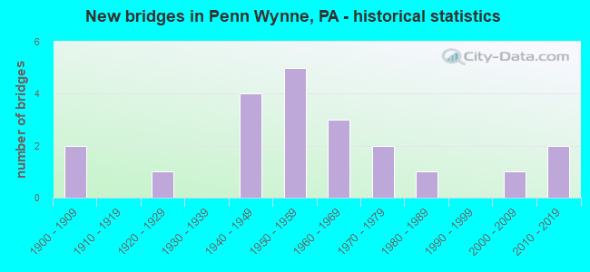
- New bridges - historical statistics
- 21900-1909
- 11920-1929
- 41940-1949
- 51950-1959
- 31960-1969
- 21970-1979
- 11980-1989
- 12000-2009
- 22010-2019

- Reconstructed bridges - Historical Statistics
- 21970-1979
- 21980-1989
- 21990-1999
- 22000-2009
- 22010-2019


- Bridge Condition - Deck
- 5.3%Excellent
- 10.5%Very good
- 36.8%Good
- 5.3%Satisfactory
- 42.1%Fair

- Bridge Condition - Superstructure
- 30.0%Very good
- 5.0%Good
- 20.0%Satisfactory
- 35.0%Fair
- 10.0%Poor

- Bridge Condition - Substructure
- 5.0%Very good
- 25.0%Good
- 35.0%Satisfactory
- 25.0%Fair
- 10.0%Poor

- Bridge Condition - Channel
- 28.6%Good
- 28.6%Satisfactory
- 28.6%Fair
- 14.3%Poor
Find on map >> Show street view
Structure Number: 15419, Location: At Karakung Dr 3588-D3 (Lat: 39.987000, Lng: -75.291339), Route carried "on" structure: City street , Year Built: 1907, Year Reconstructed: 1984, Status: Open, Structure Length: 1.37m (4.49ft), Average Daily Traffic: 1,200 (year 2015), Truck Traffic: 2%, Average Future Daily Traffic: 1,800 (year 2035), Features Intersected: COBBS CREEK, Facility Carried by Structure: BEECHWOOD DRIVE
Minimum Vertical Clearance: 30+ m (98+ ft), Kilometerpoint: 0.000, Lanes on structure: 2, Owner: Town or Township Highway Agency, Approaching Roadway Width: 6.4m (21.0ft), Material/Design: Concrete, Design/Construction: Arch - Deck, Number Of Spans In Main Unit: 1, Length of Maximum Span: 13.7m (44.9ft), Curb or Sidewalk Widths: Left: 1.5m (4.9ft), Right: 0.0m, Curb-To-Curb Width: 6.7m (22.0ft), Out-to-Out Width: 7.7m (25.3ft)
Condition: Superstructure: Fair, Substructure: Poor, Channel: Poor, Operating Rating: 49.0 metric tons, Method Used To Determine Operating Rating: Field evaluation and documented engineering judgment, Inventory Rating: 32.7 metric tons, Method Used To Determine Inventory Rating: Field evaluation and documented engineering judgment, Structural Evaluation: Meets minimum limits, Deck Geometry: High priority of corrective action, Waterway Adequacy: Equal to present desirable criteria, Approach Roadway Alignment: Equal to present desirable criteria, Length Of Structure Improvement: 1.70m (5.58ft), Designated Inspection Frequency: Every 24 months, Inspection Date: July 2020
Find on map >> Show street view
Structure Number: 23566, Location: WEST OF BALLIETTSVILLE (Lat: 40.669650, Lng: -75.596581), Route carried "on" structure: Interstate 476, Year Built: 1955, Status: Open, Structure Length: 5.03m (16.50ft), Average Daily Traffic: 30,563 (year 2004), Truck Traffic: 16%, Average Future Daily Traffic: 39,946 (year 2030), Design Load: HS 20, Features Intersected: SR 4010, LR39091
Minimum Vertical Clearance: 30+ m (98+ ft), Kilometerpoint: 0.000, Lanes on structure: 4, Lanes under structure: 2, Base Highway Network: Yes, Toll: On toll road, Owner: State Toll Authority, Approaching Roadway Width: 20.4m (66.9ft), Skew: 31 degrees, Material/Design: Steel, Design/Construction: Stringer/Multi-beam, Number Of Spans In Main Unit: 3, Length of Maximum Span: 14.3m (46.9ft), Curb or Sidewalk Widths: Left: 0.5m (1.6ft), Right: 0.5m (1.6ft), Curb-To-Curb Width: 16.5m (54.1ft), Out-to-Out Width: 19.5m (64.0ft)
Condition: Deck: Fair, Superstructure: Fair, Substructure: Satisfactory, Operating Rating: 50.8 metric tons, Method Used To Determine Operating Rating: Load Factor (LF), Inventory Rating: 29.9 metric tons, Method Used To Determine Inventory Rating: Load Factor (LF), Structural Evaluation: Somewhat better than minimum adequacy, Deck Geometry: High priority of replacement, Underclear: High priority of corrective action, Approach Roadway Alignment: Equal to present desirable criteria, Length Of Structure Improvement: 6.00m (19.69ft), Designated Inspection Frequency: Every 24 months, Inspection Date: September 2020, Bridge Improvement Cost: $28,000, Roadway Improvement Cost: $81,000, Total Project Cost: $372,000, Deck Structure Type: Concrete Cast-file-Place, Wearing Surface/Protective System: Wearing Surface: Bituminous
Find on map >> Show street view
Structure Number: 23667, Location: BUTLER TWP OVER PA 309 (Lat: 41.053614, Lng: -75.959897), Route carried "on" structure: Interstate 80, Year Built: 1966, Year Reconstructed: 1989, Status: Open, Structure Length: 4.21m (13.81ft), Average Daily Traffic: 12,150 (year 2021), Truck Traffic: 41%, Average Future Daily Traffic: 12,854 (year 2032), Design Load: HS 20+Mod, Features Intersected: SR 0309
Minimum Vertical Clearance: 30+ m (98+ ft), Kilometerpoint: 24.494, Lanes on structure: 2, Lanes under structure: 4, Base Highway Network: Yes, Owner: State Highway Agency, Approaching Roadway Width: 13.4m (44.0ft), Skew: 10 degrees, Material/Design: Prestressed concrete, Design/Construction: Box Beam or Girders - Single/Spread, Number Of Spans In Main Unit: 3, Length of Maximum Span: 20.7m (67.9ft), Curb or Sidewalk Widths: Left: 0.2m (0.7ft), Right: 0.2m (0.7ft), Curb-To-Curb Width: 12.4m (40.7ft), Out-to-Out Width: 13.9m (45.6ft)
Condition: Deck: Fair, Superstructure: Fair, Substructure: Fair, Operating Rating: 52.6 metric tons, Method Used To Determine Operating Rating: Load Factor (LF), Inventory Rating: 25.4 metric tons, Method Used To Determine Inventory Rating: Load Factor (LF), Structural Evaluation: Somewhat better than minimum adequacy, Deck Geometry: Better than present minimum criteria, Underclear: Meets minimum limits, Approach Roadway Alignment: Equal to present desirable criteria, Length Of Structure Improvement: 5.10m (16.73ft), Designated Inspection Frequency: Every 24 months, Inspection Date: September 2021, Bridge Improvement Cost: $17,000, Roadway Improvement Cost: $49,000, Total Project Cost: $225,000, Deck Structure Type: Concrete Cast-file-Place, Wearing Surface/Protective System: Wearing Surface: Bituminous
Find on map >> Show street view
Structure Number: 2368, Location: HAZLE TWP 1 M N CNTY LINE (Lat: 40.912672, Lng: -76.019269), Route carried "on" structure: Interstate 81, Year Built: 1967, Status: Open, Structure Length: 0.70m (2.30ft), Average Daily Traffic: 28,830 (year 2021), Truck Traffic: 30%, Average Future Daily Traffic: 31,066 (year 2032), Design Load: HS 20+Mod, Features Intersected: CATAWISSA CREEK
Minimum Vertical Clearance: 30+ m (98+ ft), Kilometerpoint: 0.703, Lanes on structure: 2, Base Highway Network: Yes, Owner: State Highway Agency, Approaching Roadway Width: 23.2m (76.1ft), Skew: 23 degrees, Material/Design: Concrete, Design/Construction: Culvert, Number Of Spans In Main Unit: 1, Length of Maximum Span: 7.0m (23.0ft)
Condition: Channel: Satisfactory, Culverts: Satisfactory, Operating Rating: 49.0 metric tons, Method Used To Determine Operating Rating: Field evaluation and documented engineering judgment, Inventory Rating: 32.7 metric tons, Method Used To Determine Inventory Rating: Field evaluation and documented engineering judgment, Structural Evaluation: Equal to present minimum criteria, Waterway Adequacy: Superior to present desirable criteria, Approach Roadway Alignment: Equal to present desirable criteria, Length Of Structure Improvement: 0.70m (2.30ft), Designated Inspection Frequency: Every 24 months, Inspection Date: August 2021, Bridge Improvement Cost: $74,000, Roadway Improvement Cost: $218,000, Total Project Cost: $1,000,000
Find on map >> Show street view
Structure Number: 23699, Location: BUTLER TWP OVER I-80 WB (Lat: 41.046828, Lng: -76.012928), Route carried "on" structure: Interstate 81, Year Built: 1965, Year Reconstructed: 1983, Status: Open, Structure Length: 2.99m (9.81ft), Average Daily Traffic: 17,034 (year 2021), Truck Traffic: 47%, Average Future Daily Traffic: 30,064 (year 2032), Design Load: HS 20+Mod, Features Intersected: I-80 WB
Minimum Vertical Clearance: 30+ m (98+ ft), Kilometerpoint: 18.229, Lanes on structure: 2, Lanes under structure: 3, Base Highway Network: Yes, Owner: State Highway Agency, Approaching Roadway Width: 12.8m (42.0ft), Skew: 14 degrees, Material/Design: Prestressed concrete, Design/Construction: Stringer/Multi-beam, Number Of Spans In Main Unit: 1, Length of Maximum Span: 29.0m (95.1ft), Curb or Sidewalk Widths: Left: 0.2m (0.7ft), Right: 0.2m (0.7ft), Curb-To-Curb Width: 12.4m (40.7ft), Out-to-Out Width: 13.9m (45.6ft)
Condition: Deck: Fair, Superstructure: Satisfactory, Substructure: Poor, Operating Rating: 76.2 metric tons, Method Used To Determine Operating Rating: Load Factor (LF), Inventory Rating: 41.7 metric tons, Method Used To Determine Inventory Rating: Load Factor (LF), Structural Evaluation: Meets minimum limits, Deck Geometry: Better than present minimum criteria, Underclear: High priority of corrective action, Approach Roadway Alignment: Equal to present desirable criteria, Length Of Structure Improvement: 3.00m (9.84ft), Designated Inspection Frequency: Every 24 months, Inspection Date: September 2021, Bridge Improvement Cost: $15,000, Roadway Improvement Cost: $100,000, Total Project Cost: $198,000, Deck Structure Type: Concrete Cast-file-Place, Wearing Surface/Protective System: Wearing Surface: Latex Concrete
Find on map >> Show street view
Structure Number: 24568, Location: VILLAGE OF ANTES FORT (Lat: 41.189667, Lng: -77.230492), Route carried "on" structure: State highway 44, Year Built: 1948, Year Reconstructed: 2009, Status: Open, Structure Length: 6.77m (22.21ft), Average Daily Traffic: 3,955 (year 2020), Truck Traffic: 10%, Average Future Daily Traffic: 5,595 (year 2032), Design Load: HS 20, Features Intersected: NORFOLK SOUTHERN RR
Minimum Vertical Clearance: 30+ m (98+ ft), Kilometerpoint: 27.805, Lanes on structure: 2, Base Highway Network: Yes, Owner: State Highway Agency, Approaching Roadway Width: 9.1m (29.9ft), Material/Design: Steel continuous, Design/Construction: Stringer/Multi-beam, Number Of Spans In Main Unit: 3, Length of Maximum Span: 25.9m (85.0ft), Curb or Sidewalk Widths: Left: 0.0m, Right: 1.5m (4.9ft), Curb-To-Curb Width: 7.3m (24.0ft), Out-to-Out Width: 9.8m (32.2ft)
Condition: Deck: Satisfactory, Superstructure: Satisfactory, Substructure: Satisfactory, Operating Rating: 57.2 metric tons, Method Used To Determine Operating Rating: Load Factor (LF), Inventory Rating: 34.5 metric tons, Method Used To Determine Inventory Rating: Load Factor (LF), Structural Evaluation: Equal to present minimum criteria, Deck Geometry: High priority of replacement, Underclear: High priority of corrective action, Approach Roadway Alignment: Equal to present desirable criteria, Length Of Structure Improvement: 6.80m (22.31ft), Designated Inspection Frequency: Every 24 months, Inspection Date: April 2021, Bridge Improvement Cost: $162,000, Roadway Improvement Cost: $138,000, Total Project Cost: $2,793,000, Deck Structure Type: Concrete Cast-file-Place, Wearing Surface/Protective System: Wearing Surface: Latex Concrete
Find on map >> Show street view
Structure Number: 28022, Location: .3 Mi SW US-30 3588-G2 (Lat: 39.992047, Lng: -75.272186), Route carried "on" structure: City street , Year Built: 1955, Year Reconstructed: 2016, Status: Open, Structure Length: 0.67m (2.20ft), Average Daily Traffic: 7,000 (year 2014), Truck Traffic: 1%, Average Future Daily Traffic: 8,000 (year 2034), Design Load: HL 93, Features Intersected: W. BRANCH INDIAN CREEK, Facility Carried by Structure: REMINGTON ROAD
Minimum Vertical Clearance: 30+ m (98+ ft), Kilometerpoint: 0.000, Lanes on structure: 2, Owner: Town or Township Highway Agency, Approaching Roadway Width: 11.0m (36.1ft), Material/Design: Prestressed concrete, Design/Construction: Box Beam or Girders - Multiple, Number Of Spans In Main Unit: 1, Length of Maximum Span: 6.4m (21.0ft), Curb or Sidewalk Widths: Left: 2.8m (9.2ft), Right: 2.8m (9.2ft), Curb-To-Curb Width: 11.0m (36.1ft), Out-to-Out Width: 17.6m (57.7ft)
Condition: Deck: Good, Superstructure: Very good, Substructure: Good, Channel: Satisfactory, Operating Rating: 53.8 metric tons, Method Used To Determine Operating Rating: Assigned ratings based on Load and Resistance Factor Design (LRFD) reported by rating factor (RF) using HL93 loadings, Inventory Rating: 37.3 metric tons, Method Used To Determine Inventory Rating: Assigned ratings based on Load and Resistance Factor Design (LRFD) reported by rating factor (RF) using HL93 loadings, Structural Evaluation: Better than present minimum criteria, Deck Geometry: Meets minimum limits, Waterway Adequacy: Better than present minimum criteria, Approach Roadway Alignment: Equal to present desirable criteria, Length Of Structure Improvement: 0.80m (2.62ft), Designated Inspection Frequency: Every 24 months, Inspection Date: October 2020, Wearing Surface/Protective System: Wearing Surface: Monolithic Concrete, Deck Protection: Epoxy Coated Reinforcing
Find on map >> Show street view
Structure Number: 28197, Location: EAST OF WILLOW GROVE INTG (Lat: 40.163336, Lng: -75.104628), Route carried "on" structure: Interstate 276, Year Built: 1954, Year Reconstructed: 1985, Status: Open, Structure Length: 5.64m (18.50ft), Average Daily Traffic: 92,381 (year 2004), Truck Traffic: 12%, Average Future Daily Traffic: 115,419 (year 2030), Design Load: HS 20, Features Intersected: PENNYPACK CREEK
Minimum Vertical Clearance: 30+ m (98+ ft), Kilometerpoint: 0.000, Lanes on structure: 6, Base Highway Network: Yes, Toll: On toll road, Owner: State Toll Authority, Approaching Roadway Width: 23.2m (76.1ft), Skew: 30 degrees, Material/Design: Steel continuous, Design/Construction: Stringer/Multi-beam, Number Of Spans In Main Unit: 3, Length of Maximum Span: 21.6m (70.9ft), Curb or Sidewalk Widths: Left: 0.2m (0.7ft), Right: 0.2m (0.7ft), Curb-To-Curb Width: 31.1m (102.0ft), Out-to-Out Width: 32.0m (105.0ft)
Condition: Deck: Fair, Superstructure: Fair, Substructure: Fair, Channel: Good, Operating Rating: 68.9 metric tons, Method Used To Determine Operating Rating: Load Factor (LF), Inventory Rating: 40.8 metric tons, Method Used To Determine Inventory Rating: Load Factor (LF), Structural Evaluation: Somewhat better than minimum adequacy, Deck Geometry: Superior to present desirable criteria, Waterway Adequacy: Superior to present desirable criteria, Approach Roadway Alignment: Equal to present desirable criteria, Length Of Structure Improvement: 6.50m (21.33ft), Designated Inspection Frequency: Every 24 months, Inspection Date: June 2020, Deck Structure Type: Concrete Cast-file-Place, Wearing Surface/Protective System: Wearing Surface: Latex Concrete
Find on map >> Show street view
Structure Number: 28198, Location: SOUTH OF HATBORO (Lat: 40.162714, Lng: -75.090244), Route carried "on" structure: State highway , Year Built: 1954, Status: Open, Structure Length: 5.06m (16.60ft), Average Daily Traffic: 14,333 (year 2022), Truck Traffic: 5%, Average Future Daily Traffic: 20,259 (year 2030), Design Load: HS 20, Features Intersected: PA TPK (I-276), Facility Carried by Structure: LR 46094,SR 2042
Minimum Vertical Clearance: 30+ m (98+ ft), Kilometerpoint: 2.766, Lanes on structure: 2, Lanes under structure: 6, Owner: State Toll Authority, Approaching Roadway Width: 11.6m (38.1ft), Skew: 3 degrees, Material/Design: Steel, Design/Construction: Stringer/Multi-beam, Number Of Spans In Main Unit: 3, Length of Maximum Span: 31.4m (103.0ft), Curb or Sidewalk Widths: Left: 0.5m (1.6ft), Right: 0.5m (1.6ft), Curb-To-Curb Width: 12.2m (40.0ft), Out-to-Out Width: 14.0m (45.9ft)
Condition: Deck: Fair, Superstructure: Satisfactory, Substructure: Satisfactory, Operating Rating: 48.1 metric tons, Method Used To Determine Operating Rating: Load and Resistance Factor (LRFR), Inventory Rating: 36.3 metric tons, Method Used To Determine Inventory Rating: Load and Resistance Factor (LRFR), Structural Evaluation: Equal to present minimum criteria, Deck Geometry: Somewhat better than minimum adequacy, Underclear: High priority of corrective action, Approach Roadway Alignment: Equal to present desirable criteria, Length Of Structure Improvement: 6.00m (19.69ft), Designated Inspection Frequency: Every 24 months, Inspection Date: April 2020, Bridge Improvement Cost: $74,000, Roadway Improvement Cost: $218,000, Total Project Cost: $998,000, Deck Structure Type: Concrete Cast-file-Place, Wearing Surface/Protective System: Wearing Surface: Monolithic Concrete
Find on map >> Show street view
Structure Number: 28743, Location: CHURCH RD. OVER PA.33 (Lat: 40.678733, Lng: -75.289553), Route carried "on" structure: State highway , Year Built: 1972, Year Reconstructed: 2001, Status: Open, Structure Length: 9.72m (31.89ft), Average Daily Traffic: 3,653 (year 2022), Truck Traffic: 3%, Average Future Daily Traffic: 3,643 (year 2036), Design Load: HS 20, Features Intersected: PA 33 (LR 1098), Facility Carried by Structure: SR 2028 (LR 48017)
Minimum Vertical Clearance: 30+ m (98+ ft), Kilometerpoint: 5.699, Lanes on structure: 2, Lanes under structure: 8, Owner: State Highway Agency, Approaching Roadway Width: 14.3m (46.9ft), Skew: 2 degrees, Material/Design: Steel continuous, Design/Construction: Stringer/Multi-beam, Number Of Spans In Main Unit: 2, Number Of Approach Spans: 2, Length of Maximum Span: 36.6m (120.1ft), Curb or Sidewalk Widths: Left: 1.5m (4.9ft), Right: 1.5m (4.9ft), Curb-To-Curb Width: 10.8m (35.4ft), Out-to-Out Width: 14.9m (48.9ft)
Condition: Deck: Good, Superstructure: Satisfactory, Substructure: Satisfactory, Operating Rating: 59.9 metric tons, Method Used To Determine Operating Rating: Load Factor (LF), Inventory Rating: 35.4 metric tons, Method Used To Determine Inventory Rating: Load Factor (LF), Structural Evaluation: Equal to present minimum criteria, Deck Geometry: Somewhat better than minimum adequacy, Underclear: High priority of corrective action, Approach Roadway Alignment: Equal to present desirable criteria, Length Of Structure Improvement: 10.70m (35.10ft), Designated Inspection Frequency: Every 24 months, Inspection Date: November 2019, Bridge Improvement Cost: $29,000, Roadway Improvement Cost: $84,000, Total Project Cost: $386,000, Deck Structure Type: Concrete Cast-file-Place, Wearing Surface/Protective System: Wearing Surface: Latex Concrete
Find on map >> Show street view
Structure Number: 30182, Location: GOLD (Lat: 41.872308, Lng: -77.837194), Route carried "on" structure: State highway 49, Year Built: 1947, Status: Open, Structure Length: 0.79m (2.59ft), Average Daily Traffic: 1,336 (year 2021), Truck Traffic: 16%, Average Future Daily Traffic: 1,733 (year 2040), Design Load: HS 20, Features Intersected: MIDDLE BR GENESEE RIVER
Minimum Vertical Clearance: 30+ m (98+ ft), Kilometerpoint: 17.069, Lanes on structure: 2, Base Highway Network: Yes, Owner: State Highway Agency, Approaching Roadway Width: 7.9m (25.9ft), Skew: 1 degrees, Material/Design: Concrete, Design/Construction: Tee Beam, Number Of Spans In Main Unit: 1, Length of Maximum Span: 7.6m (24.9ft), Curb or Sidewalk Widths: Left: 0.2m (0.7ft), Right: 0.2m (0.7ft), Curb-To-Curb Width: 12.2m (40.0ft), Out-to-Out Width: 13.1m (43.0ft)
Condition: Deck: Fair, Superstructure: Poor, Substructure: Fair, Channel: Good, Operating Rating: 57.2 metric tons, Method Used To Determine Operating Rating: Field evaluation and documented engineering judgment, Inventory Rating: 34.5 metric tons, Method Used To Determine Inventory Rating: Field evaluation and documented engineering judgment, Structural Evaluation: Meets minimum limits, Deck Geometry: Better than present minimum criteria, Waterway Adequacy: Equal to present desirable criteria, Approach Roadway Alignment: Better than present minimum criteria, Length Of Structure Improvement: 0.80m (2.62ft), Designated Inspection Frequency: Every 24 months, Inspection Date: September 2020, Bridge Improvement Cost: $27,000, Roadway Improvement Cost: $237,000, Total Project Cost: $367,000, Deck Structure Type: Concrete Cast-file-Place, Wearing Surface/Protective System: Wearing Surface: Bituminous
Find on map >> Show street view
Structure Number: 30184, Location: 1 MI SW ULYSSES (Lat: 41.892194, Lng: -77.790358), Route carried "on" structure: State highway 49, Year Built: 1928, Status: Open, Structure Length: 0.79m (2.59ft), Average Daily Traffic: 1,183 (year 2020), Truck Traffic: 15%, Average Future Daily Traffic: 1,670 (year 2040), Design Load: H 15, Features Intersected: LUDINGTON RUN
Minimum Vertical Clearance: 30+ m (98+ ft), Kilometerpoint: 21.716, Lanes on structure: 2, Base Highway Network: Yes, Owner: State Highway Agency, Approaching Roadway Width: 8.5m (27.9ft), Skew: 4 degrees, Material/Design: Concrete, Design/Construction: Tee Beam, Number Of Spans In Main Unit: 1, Length of Maximum Span: 7.6m (24.9ft), Curb-To-Curb Width: 9.9m (32.5ft), Out-to-Out Width: 11.0m (36.1ft)
Condition: Deck: Good, Superstructure: Fair, Substructure: Fair, Channel: Fair, Operating Rating: 78.0 metric tons, Method Used To Determine Operating Rating: Allowable Stress (AS), Inventory Rating: 48.1 metric tons, Method Used To Determine Inventory Rating: Allowable Stress (AS), Structural Evaluation: Somewhat better than minimum adequacy, Deck Geometry: Somewhat better than minimum adequacy, Waterway Adequacy: Equal to present minimum criteria, Approach Roadway Alignment: Equal to present desirable criteria, Length Of Structure Improvement: 0.80m (2.62ft), Designated Inspection Frequency: Every 24 months, Inspection Date: September 2020, Bridge Improvement Cost: $31,000, Roadway Improvement Cost: $237,000, Total Project Cost: $415,000, Deck Structure Type: Concrete Cast-file-Place, Wearing Surface/Protective System: Wearing Surface: Bituminous, Membrane: Preformed Fabric, Deck Protection: Epoxy Coated Reinforcing
Find on map >> Show street view
Structure Number: 32109, Location: 3.1 MI. N. OF HILLSGROVE (Lat: 41.485492, Lng: -76.700292), Route carried "on" structure: City street , Year Built: 1976, Year Reconstructed: 2014, Status: Open, Structure Length: 1.89m (6.20ft), Average Daily Traffic: 33 (year 2019), Average Future Daily Traffic: 51 (year 2041), Design Load: HS 20, Features Intersected: HOAGLAND BRANCH, Facility Carried by Structure: FOX TWP T-408
Minimum Vertical Clearance: 30+ m (98+ ft), Kilometerpoint: 0.000, Lanes on structure: 2, Owner: Town or Township Highway Agency, Approaching Roadway Width: 4.3m (14.1ft), Skew: 1 degrees, Material/Design: Prestressed concrete, Design/Construction: Box Beam or Girders - Multiple, Number Of Spans In Main Unit: 1, Length of Maximum Span: 18.3m (60.0ft), Curb-To-Curb Width: 7.0m (23.0ft), Out-to-Out Width: 7.4m (24.3ft)
Condition: Deck: Good, Superstructure: Fair, Substructure: Satisfactory, Channel: Satisfactory, Operating Rating: 44.5 metric tons, Method Used To Determine Operating Rating: Load Factor (LF), Inventory Rating: 21.8 metric tons, Method Used To Determine Inventory Rating: Load Factor (LF), Structural Evaluation: Somewhat better than minimum adequacy, Deck Geometry: Somewhat better than minimum adequacy, Waterway Adequacy: Better than present minimum criteria, Approach Roadway Alignment: Equal to present desirable criteria, Length Of Structure Improvement: 1.90m (6.23ft), Designated Inspection Frequency: Every 24 months, Inspection Date: September 2021, Deck Structure Type: Other, Wearing Surface/Protective System: Wearing Surface: Bituminous
Find on map >> Show street view
Structure Number: 35347, Location: 200' WEST OF SR 2011 (Lat: 40.041508, Lng: -80.101200), Route carried "on" structure: City street T365, Year Built: 1907, Year Reconstructed: 1998, Status: Open, Structure Length: 1.13m (3.71ft), Average Daily Traffic: 50 (year 2019), Average Future Daily Traffic: 50 (year 2039), Design Load: HS 25 or greater, Features Intersected: Little Daniels Run, Facility Carried by Structure: T369 Wherry School
Minimum Vertical Clearance: 30+ m (98+ ft), Kilometerpoint: 0.000, Lanes on structure: 1, Owner: County Highway Agency, Approaching Roadway Width: 3.4m (11.2ft), Material/Design: Prestressed concrete, Design/Construction: Box Beam or Girders - Single/Spread, Number Of Spans In Main Unit: 1, Length of Maximum Span: 9.8m (32.2ft), Curb or Sidewalk Widths: Left: 0.2m (0.7ft), Right: 0.2m (0.7ft), Curb-To-Curb Width: 3.9m (12.8ft), Out-to-Out Width: 5.0m (16.4ft)
Condition: Deck: Good, Superstructure: Very good, Substructure: Good, Channel: Satisfactory, Operating Rating: 70.8 metric tons, Method Used To Determine Operating Rating: Load Factor (LF), Inventory Rating: 41.7 metric tons, Method Used To Determine Inventory Rating: Load Factor (LF), Structural Evaluation: Better than present minimum criteria, Deck Geometry: Meets minimum limits, Waterway Adequacy: Better than present minimum criteria, Approach Roadway Alignment: Better than present minimum criteria, Length Of Structure Improvement: 1.10m (3.61ft), Designated Inspection Frequency: Every 24 months, Inspection Date: September 2021, Bridge Improvement Cost: $4,000, Roadway Improvement Cost: $11,000, Total Project Cost: $48,000, Deck Structure Type: Concrete Cast-file-Place, Wearing Surface/Protective System: Wearing Surface: Monolithic Concrete, Deck Protection: Epoxy Coated Reinforcing
Find on map >> Show street view
Structure Number: 36167, Location: LIGONIER TOWNSHIP (Lat: 40.266917, Lng: -79.260403), Route carried "on" structure: State highway 259, Year Built: 1950, Status: Posted for load, Structure Length: 1.13m (3.71ft), Average Daily Traffic: 744 (year 2021), Truck Traffic: 5%, Average Future Daily Traffic: 1,031 (year 2032), Design Load: H 20, Features Intersected: TROUT RUN
Minimum Vertical Clearance: 30+ m (98+ ft), Kilometerpoint: 1.062, Lanes on structure: 2, Owner: State Highway Agency, Approaching Roadway Width: 6.7m (22.0ft), Material/Design: Steel, Design/Construction: Stringer/Multi-beam, Number Of Spans In Main Unit: 1, Length of Maximum Span: 11.0m (36.1ft), Curb or Sidewalk Widths: Left: 0.2m (0.7ft), Right: 0.2m (0.7ft), Curb-To-Curb Width: 6.5m (21.3ft), Out-to-Out Width: 7.6m (24.9ft)
Condition: Deck: Fair, Superstructure: Poor, Substructure: Satisfactory, Channel: Fair, Operating Rating: 49.0 metric tons, Method Used To Determine Operating Rating: Load Factor (LF), Inventory Rating: 29.0 metric tons, Method Used To Determine Inventory Rating: Load Factor (LF), Structural Evaluation: Meets minimum limits, Deck Geometry: High priority of corrective action, Waterway Adequacy: Superior to present desirable criteria, Approach Roadway Alignment: Equal to present desirable criteria, Length Of Structure Improvement: 1.70m (5.58ft), Designated Inspection Frequency: Every 24 months, Other Special Inspection Frequency: Every 12 months, Inspection Date: June 2021, Other Special Inspection Date: June 2021, Bridge Improvement Cost: $8,000, Roadway Improvement Cost: $25,000, Total Project Cost: $113,000, Deck Structure Type: Closed Grating, Wearing Surface/Protective System: Wearing Surface: Bituminous
Find on map >> Show street view
Structure Number: 4565, Location: 4 MI WEST OF LIBERTY (Lat: 41.580236, Lng: -77.177756), Route carried "on" structure: State highway 414, Year Built: 2009, Status: Open, Structure Length: 1.86m (6.10ft), Average Daily Traffic: 1,871 (year 2022), Truck Traffic: 19%, Average Future Daily Traffic: 3,082 (year 2032), Design Load: HL 93, Features Intersected: ZIMMERMAN CREEK
Minimum Vertical Clearance: 30+ m (98+ ft), Kilometerpoint: 20.843, Lanes on structure: 2, Base Highway Network: Yes, Owner: State Highway Agency, Approaching Roadway Width: 8.2m (26.9ft), Material/Design: Prestressed concrete, Design/Construction: Box Beam or Girders - Multiple, Number Of Spans In Main Unit: 1, Length of Maximum Span: 17.7m (58.1ft), Curb or Sidewalk Widths: Left: 0.2m (0.7ft), Right: 0.2m (0.7ft), Curb-To-Curb Width: 9.1m (29.9ft), Out-to-Out Width: 10.2m (33.5ft)
Condition: Deck: Very good, Superstructure: Very good, Substructure: Very good, Channel: Good, Operating Rating: 61.7 metric tons, Method Used To Determine Operating Rating: Load and Resistance Factor (LRFR), Inventory Rating: 39.0 metric tons, Method Used To Determine Inventory Rating: Load and Resistance Factor (LRFR), Structural Evaluation: Equal to present desirable criteria, Deck Geometry: Somewhat better than minimum adequacy, Waterway Adequacy: Superior to present desirable criteria, Approach Roadway Alignment: Equal to present desirable criteria, Designated Inspection Frequency: Every 48 months, Inspection Date: September 2019, Deck Structure Type: Concrete Cast-file-Place, Wearing Surface/Protective System: Wearing Surface: Monolithic Concrete, Deck Protection: Epoxy Coated Reinforcing
Find on map >> Show street view
Structure Number: 4622, Location: GREENSBURG PIKE O/ RT 30 (Lat: 40.381111, Lng: -79.816611), Route carried "on" structure: State highway , Year Built: 2010, Status: Open, Structure Length: 5.18m (16.99ft), Average Daily Traffic: 2,955 (year 2022), Truck Traffic: 7%, Average Future Daily Traffic: 5,724 (year 2032), Design Load: HL 93, Features Intersected: LINCOLN HIGHWAY, Facility Carried by Structure: GREENSBURG PIKE
Minimum Vertical Clearance: 30+ m (98+ ft), Kilometerpoint: 0.000, Lanes on structure: 2, Lanes under structure: 4, Owner: State Highway Agency, Approaching Roadway Width: 11.0m (36.1ft), Skew: 4 degrees, Material/Design: Steel, Design/Construction: Stringer/Multi-beam, Number Of Spans In Main Unit: 1, Length of Maximum Span: 51.2m (168.0ft), Curb or Sidewalk Widths: Left: 1.6m (5.2ft), Right: 0.2m (0.7ft), Curb-To-Curb Width: 11.0m (36.1ft), Out-to-Out Width: 13.3m (43.6ft)
Condition: Deck: Good, Superstructure: Very good, Substructure: Good, Operating Rating: 71.7 metric tons, Method Used To Determine Operating Rating: Load and Resistance Factor (LRFR), Inventory Rating: 42.6 metric tons, Method Used To Determine Inventory Rating: Load and Resistance Factor (LRFR), Structural Evaluation: Better than present minimum criteria, Deck Geometry: Somewhat better than minimum adequacy, Underclear: Equal to present minimum criteria, Approach Roadway Alignment: Better than present minimum criteria, Designated Inspection Frequency: Every 24 months, Inspection Date: March 2020, Deck Structure Type: Concrete Cast-file-Place, Wearing Surface/Protective System: Wearing Surface: Monolithic Concrete, Deck Protection: Epoxy Coated Reinforcing
Find on map >> Show street view
Structure Number: 47474, Location: 0.2 Mi N US-30 3588-H2 (Lat: 39.992664, Lng: -75.262214), Route carried "on" structure: City street 308, Year Built: 1986, Year Reconstructed: 2016, Status: Open, Structure Length: 0.91m (2.99ft), Average Daily Traffic: 500 (year 2012), Truck Traffic: 1%, Average Future Daily Traffic: 627 (year 2032), Design Load: HL 93, Features Intersected: East Branch Indian Creek, Facility Carried by Structure: Violet Lane
Minimum Vertical Clearance: 30+ m (98+ ft), Kilometerpoint: 0.000, Lanes on structure: 2, Owner: Town or Township Highway Agency, Approaching Roadway Width: 8.2m (26.9ft), Skew: 2 degrees, Material/Design: Prestressed concrete, Design/Construction: Box Beam or Girders - Multiple, Number Of Spans In Main Unit: 1, Length of Maximum Span: 8.8m (28.9ft), Curb or Sidewalk Widths: Left: 2.3m (7.5ft), Right: 2.3m (7.5ft), Curb-To-Curb Width: 8.2m (26.9ft), Out-to-Out Width: 13.5m (44.3ft)
Condition: Deck: Very good, Superstructure: Very good, Substructure: Good, Channel: Fair, Operating Rating: 50.5 metric tons, Method Used To Determine Operating Rating: Assigned ratings based on Load and Resistance Factor Design (LRFD) reported by rating factor (RF) using HL93 loadings, Inventory Rating: 35.3 metric tons, Method Used To Determine Inventory Rating: Assigned ratings based on Load and Resistance Factor Design (LRFD) reported by rating factor (RF) using HL93 loadings, Structural Evaluation: Better than present minimum criteria, Deck Geometry: Somewhat better than minimum adequacy, Waterway Adequacy: Equal to present desirable criteria, Approach Roadway Alignment: Equal to present desirable criteria, Designated Inspection Frequency: Every 24 months, Inspection Date: June 2020, Wearing Surface/Protective System: Wearing Surface: Monolithic Concrete, Deck Protection: Epoxy Coated Reinforcing
Find on map >> Show street view
Structure Number: 47475, Location: .4 Mi NE US-30 3588-H1 (Lat: 39.995928, Lng: -75.263653), Route carried "on" structure: City street , Year Built: 1948, Status: Open, Structure Length: 0.76m (2.49ft), Average Daily Traffic: 500 (year 2012), Truck Traffic: 2%, Average Future Daily Traffic: 627 (year 2032), Features Intersected: East Branch Indian Creek, Facility Carried by Structure: Bowman Avenue
Minimum Vertical Clearance: 30+ m (98+ ft), Kilometerpoint: 0.000, Lanes on structure: 2, Owner: Town or Township Highway Agency, Approaching Roadway Width: 7.3m (24.0ft), Material/Design: Concrete, Design/Construction: Slab, Number Of Spans In Main Unit: 1, Length of Maximum Span: 6.1m (20.0ft), Curb or Sidewalk Widths: Left: 1.9m (6.2ft), Right: 2.0m (6.6ft), Curb-To-Curb Width: 7.3m (24.0ft), Out-to-Out Width: 12.4m (40.7ft)
Condition: Deck: Fair, Superstructure: Fair, Substructure: Fair, Channel: Poor, Operating Rating: 78.0 metric tons, Method Used To Determine Operating Rating: Field evaluation and documented engineering judgment, Inventory Rating: 46.3 metric tons, Method Used To Determine Inventory Rating: Field evaluation and documented engineering judgment, Structural Evaluation: Somewhat better than minimum adequacy, Deck Geometry: Meets minimum limits, Waterway Adequacy: Better than present minimum criteria, Approach Roadway Alignment: Equal to present desirable criteria, Designated Inspection Frequency: Every 24 months, Inspection Date: September 2020, Deck Structure Type: Concrete Cast-file-Place, Wearing Surface/Protective System: Wearing Surface: Bituminous
Find on map >> Show street view
Structure Number: 47476, Location: .3 Mi NE US-30 3588-H1 (Lat: 39.996725, Lng: -75.263908), Route carried "on" structure: City street , Year Built: 1946, Status: Open, Structure Length: 0.79m (2.59ft), Average Daily Traffic: 6,980 (year 2014), Truck Traffic: 1%, Average Future Daily Traffic: 8,000 (year 2034), Design Load: HS 20, Features Intersected: East Branch Indian Creek, Facility Carried by Structure: Remington Road
Minimum Vertical Clearance: 30+ m (98+ ft), Kilometerpoint: 0.000, Lanes on structure: 2, Owner: Town or Township Highway Agency, Approaching Roadway Width: 10.4m (34.1ft), Material/Design: Concrete continuous, Design/Construction: Slab, Number Of Spans In Main Unit: 2, Length of Maximum Span: 3.0m (9.8ft), Curb or Sidewalk Widths: Left: 3.5m (11.5ft), Right: 3.5m (11.5ft), Curb-To-Curb Width: 10.4m (34.1ft), Out-to-Out Width: 18.6m (61.0ft)
Condition: Deck: Good, Superstructure: Good, Substructure: Satisfactory, Channel: Fair, Operating Rating: 61.7 metric tons, Method Used To Determine Operating Rating: Field evaluation and documented engineering judgment, Inventory Rating: 36.3 metric tons, Method Used To Determine Inventory Rating: Field evaluation and documented engineering judgment, Structural Evaluation: Equal to present minimum criteria, Deck Geometry: Meets minimum limits, Waterway Adequacy: Better than present minimum criteria, Approach Roadway Alignment: Equal to present desirable criteria, Designated Inspection Frequency: Every 24 months, Inspection Date: September 2020, Wearing Surface/Protective System: Wearing Surface: Bituminous
Find on map >> Show street view
Structure Number: 57292, Location: E.KARAKUNG DRIVE 26J07 (Lat: 39.981128, Lng: -75.281928), Route carried "on" structure: State highway , Year Built: 2019, Status: Open, Structure Length: 1.28m (4.20ft), Average Daily Traffic: 5,100 (year 2022), Truck Traffic: 1%, Average Future Daily Traffic: 7,525 (year 2035), Design Load: HL 93, Features Intersected: COBBS CREEK, Facility Carried by Structure: MANOA ROAD
Minimum Vertical Clearance: 30+ m (98+ ft), Kilometerpoint: 3.267, Lanes on structure: 2, Owner: State Highway Agency, Approaching Roadway Width: 12.5m (41.0ft), Skew: 1 degrees, Material/Design: Prestressed concrete, Design/Construction: Stringer/Multi-beam, Number Of Spans In Main Unit: 1, Length of Maximum Span: 11.9m (39.0ft), Curb or Sidewalk Widths: Left: 1.8m (5.9ft), Right: 0.0m, Curb-To-Curb Width: 12.6m (41.3ft), Out-to-Out Width: 15.3m (50.2ft)
Condition: Deck: Excellent, Superstructure: Very good, Substructure: Good, Channel: Good, Operating Rating: 45.7 metric tons, Method Used To Determine Operating Rating: Assigned ratings based on Load and Resistance Factor Design (LRFD) reported by rating factor (RF) using HL93 loadings, Inventory Rating: 35.3 metric tons, Method Used To Determine Inventory Rating: Assigned ratings based on Load and Resistance Factor Design (LRFD) reported by rating factor (RF) using HL93 loadings, Structural Evaluation: Better than present minimum criteria, Deck Geometry: Somewhat better than minimum adequacy, Waterway Adequacy: Better than present minimum criteria, Approach Roadway Alignment: Equal to present desirable criteria, Designated Inspection Frequency: Every 24 months, Inspection Date: November 2019, Deck Structure Type: Concrete Cast-file-Place, Wearing Surface/Protective System: Wearing Surface: Monolithic Concrete, Deck Protection: Epoxy Coated Reinforcing