Bridge Statistics for Pembroke, New York (NY)
Condition, Traffic, Stress, Structural Evaluation, Project Costs
- National Bridge Inventory (NBI) Statistics
- 28Number of bridges
- 249ft / 76.2mTotal length
- $51,208,000Total costs
- 242,667Total average daily traffic
- 49,940Total average daily truck traffic
- National Bridge Inventory (NBI) Registered Bridges for Pembroke
- No street view available for this location
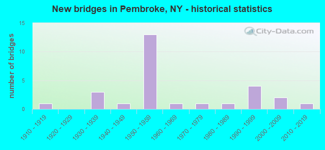
- New bridges - historical statistics
- 11910-1919
- 31930-1939
- 11940-1949
- 131950-1959
- 11960-1969
- 11970-1979
- 11980-1989
- 41990-1999
- 22000-2009
- 12010-2019

- Reconstructed bridges - Historical Statistics
- 11950-1959
- 01960-1969
- 21970-1979
- 01980-1989
- 31990-1999
- 12000-2009


- Bridge Condition - Deck
- 5.9%Excellent
- 23.5%Very good
- 17.6%Good
- 17.6%Satisfactory
- 35.3%Fair

- Bridge Condition - Superstructure
- 5.6%Excellent
- 22.2%Very good
- 22.2%Good
- 27.8%Satisfactory
- 11.1%Fair
- 11.1%Poor

- Bridge Condition - Substructure
- 5.6%Excellent
- 11.1%Very good
- 27.8%Good
- 11.1%Satisfactory
- 33.3%Fair
- 5.6%Poor
- 5.6%Serious

- Bridge Condition - Channel
- 13.3%Very good
- 40.0%Good
- 33.3%Satisfactory
- 13.3%Fair
Find on map >> Show street view
Structure Number: 100166, Location: 1 MI W JCT RTS 5 + I90 (Lat: 42.998550, Lng: -78.438767), Route carried "on" structure: State highway 5, Year Built: 1910, Status: Open, Structure Length: 1.19m (3.90ft), Average Daily Traffic: 5,964 (year 2018), Truck Traffic: 9%, Average Future Daily Traffic: 6,020 (year 2040), Design Load: H 20, Features Intersected: MURDER CREEK
Minimum Vertical Clearance: 30+ m (98+ ft), Kilometerpoint: 2.060, Lanes on structure: 2, Base Highway Network: Yes, Owner: State Highway Agency, Approaching Roadway Width: 13.1m (43.0ft), Material/Design: Concrete, Design/Construction: Arch - Deck, Number Of Spans In Main Unit: 1, Length of Maximum Span: 11.2m (36.7ft), Curb or Sidewalk Widths: Left: 0.0m, Right: 1.7m (5.6ft), Curb-To-Curb Width: 13.1m (43.0ft), Out-to-Out Width: 18.1m (59.4ft)
Condition: Superstructure: Poor, Substructure: Fair, Channel: Satisfactory, Operating Rating: 59.4 metric tons, Method Used To Determine Operating Rating: Field evaluation and documented engineering judgment, Inventory Rating: 15.6 metric tons, Method Used To Determine Inventory Rating: Field evaluation and documented engineering judgment, Structural Evaluation: High priority of corrective action, Deck Geometry: Somewhat better than minimum adequacy, Waterway Adequacy: Equal to present desirable criteria, Approach Roadway Alignment: Equal to present minimum criteria, Length Of Structure Improvement: 1.18m (3.87ft), Designated Inspection Frequency: Every 24 months, Inspection Date: October 2021, Bridge Improvement Cost: $451,000, Roadway Improvement Cost: $264,000, Total Project Cost: $716,000 ( Estimate for 2021)
Find on map >> Show street view
Structure Number: 1001679, Location: JCT RTS 5 & I90 PEMBROKE (Lat: 42.995053, Lng: -78.427092), Route carried "on" structure: Interstate 90, Year Built: 1953, Year Reconstructed: 1998, Status: Open, Structure Length: 5.64m (18.50ft), Average Daily Traffic: 30,563 (year 2020), Truck Traffic: 32%, Average Future Daily Traffic: 37,488 (year 2040), Design Load: HS 20+Mod, Features Intersected: RTE 5
Minimum Vertical Clearance: 30+ m (98+ ft), Kilometerpoint: 3.170, Lanes on structure: 4, Lanes under structure: 2, Base Highway Network: Yes, Toll: On Interstate toll segment, Owner: State Toll Authority, Approaching Roadway Width: 32.9m (107.9ft), Skew: 33 degrees, Material/Design: Steel, Design/Construction: Stringer/Multi-beam, Number Of Spans In Main Unit: 3, Length of Maximum Span: 28.0m (91.9ft), Curb or Sidewalk Widths: Left: 0.8m (2.6ft), Right: 0.8m (2.6ft), Curb-To-Curb Width: 36.3m (119.1ft), Out-to-Out Width: 37.5m (123.0ft)
Condition: Deck: Fair, Superstructure: Satisfactory, Substructure: Good, Operating Rating: 82.1 metric tons, Method Used To Determine Operating Rating: Field evaluation and documented engineering judgment, Inventory Rating: 32.7 metric tons, Method Used To Determine Inventory Rating: Field evaluation and documented engineering judgment, Structural Evaluation: Equal to present minimum criteria, Deck Geometry: Superior to present desirable criteria, Underclear: Meets minimum limits, Approach Roadway Alignment: Equal to present desirable criteria, Length Of Structure Improvement: 5.63m (18.47ft), Designated Inspection Frequency: Every 24 months, Inspection Date: May 2020, Bridge Improvement Cost: $5,126,000, Roadway Improvement Cost: $3,002,000, Total Project Cost: $8,128,000 ( Estimate for 2021), Deck Structure Type: Concrete Cast-file-Place, Wearing Surface/Protective System: Wearing Surface: Bituminous, Membrane: Other
Find on map >> Show street view
Structure Number: 102294, Location: 0.8 MI E JCT RTS 33 & 77 (Lat: 42.963208, Lng: -78.389106), Route carried "on" structure: State highway 33, Year Built: 1991, Status: Open, Structure Length: 2.74m (8.99ft), Average Daily Traffic: 3,788 (year 2019), Truck Traffic: 12%, Average Future Daily Traffic: 3,811 (year 2040), Design Load: HS 20, Features Intersected: MURDER CREEK
Minimum Vertical Clearance: 30+ m (98+ ft), Kilometerpoint: 6.339, Lanes on structure: 2, Base Highway Network: Yes, Owner: State Highway Agency, Approaching Roadway Width: 13.4m (44.0ft), Material/Design: Prestressed concrete, Design/Construction: Box Beam or Girders - Multiple, Number Of Spans In Main Unit: 1, Length of Maximum Span: 26.2m (86.0ft), Curb-To-Curb Width: 13.4m (44.0ft), Out-to-Out Width: 14.0m (45.9ft)
Condition: Deck: Very good, Superstructure: Very good, Substructure: Very good, Channel: Satisfactory, Operating Rating: 98.0 metric tons, Method Used To Determine Operating Rating: Load Factor (LF), Inventory Rating: 52.6 metric tons, Method Used To Determine Inventory Rating: Load Factor (LF), Structural Evaluation: Equal to present desirable criteria, Deck Geometry: Better than present minimum criteria, Waterway Adequacy: Equal to present minimum criteria, Approach Roadway Alignment: Equal to present desirable criteria, Length Of Structure Improvement: 2.74m (8.99ft), Designated Inspection Frequency: Every 24 months, Inspection Date: October 2021, Bridge Improvement Cost: $693,000, Roadway Improvement Cost: $406,000, Total Project Cost: $1,099,000 ( Estimate for 2021), Deck Structure Type: Concrete Cast-file-Place, Wearing Surface/Protective System: Wearing Surface: Bituminous, Membrane: Other, Deck Protection: Epoxy Coated Reinforcing
Find on map >> Show street view
Structure Number: 103008, Location: JCT RT 77 & NYS THRUWAY (Lat: 43.007028, Lng: -78.405308), Route carried "on" structure: State highway 77, Year Built: 1994, Status: Open, Structure Length: 7.77m (25.49ft), Average Daily Traffic: 6,841 (year 2020), Truck Traffic: 21%, Average Future Daily Traffic: 6,905 (year 2040), Design Load: HS 25 or greater, Features Intersected: 90IX EB, TRIB TO MURDER
Minimum Vertical Clearance: 30+ m (98+ ft), Kilometerpoint: 15.591, Lanes on structure: 2, Lanes under structure: 6, Base Highway Network: Yes, Owner: State Toll Authority, Approaching Roadway Width: 10.4m (34.1ft), Skew: 3 degrees, Material/Design: Steel continuous, Design/Construction: Stringer/Multi-beam, Number Of Spans In Main Unit: 2, Length of Maximum Span: 38.1m (125.0ft), Curb-To-Curb Width: 10.2m (33.5ft), Out-to-Out Width: 11.2m (36.7ft)
Condition: Deck: Fair, Superstructure: Good, Substructure: Good, Channel: Very good, Operating Rating: 87.1 metric tons, Method Used To Determine Operating Rating: Load Factor (LF), Inventory Rating: 45.4 metric tons, Method Used To Determine Inventory Rating: Load Factor (LF), Structural Evaluation: Better than present minimum criteria, Deck Geometry: Meets minimum limits, Underclear: High priority of corrective action, Waterway Adequacy: Superior to present desirable criteria, Approach Roadway Alignment: Equal to present desirable criteria, Length Of Structure Improvement: 7.77m (25.49ft), Designated Inspection Frequency: Every 24 months, Inspection Date: March 2021, Bridge Improvement Cost: $2,243,000, Roadway Improvement Cost: $1,313,000, Total Project Cost: $3,556,000 ( Estimate for 2021), Deck Structure Type: Concrete Cast-file-Place, Wearing Surface/Protective System: Wearing Surface: Integral Concrete, Deck Protection: Epoxy Coated Reinforcing
Find on map >> Show street view
Structure Number: 103009, Location: JCT RT 77 & TONAWANDA CK (Lat: 43.027303, Lng: -78.397472), Route carried "on" structure: State highway 77, Year Built: 1987, Status: Open, Structure Length: 5.18m (16.99ft), Average Daily Traffic: 5,973 (year 2020), Truck Traffic: 18%, Average Future Daily Traffic: 6,029 (year 2040), Design Load: HS 20, Features Intersected: TONAWANDA CREEK
Minimum Vertical Clearance: 30+ m (98+ ft), Kilometerpoint: 17.989, Lanes on structure: 2, Base Highway Network: Yes, Owner: State Highway Agency, Approaching Roadway Width: 11.6m (38.1ft), Material/Design: Steel continuous, Design/Construction: Stringer/Multi-beam, Number Of Spans In Main Unit: 2, Length of Maximum Span: 25.6m (84.0ft), Curb-To-Curb Width: 11.6m (38.1ft), Out-to-Out Width: 12.2m (40.0ft)
Condition: Deck: Good, Superstructure: Good, Substructure: Satisfactory, Channel: Satisfactory, Operating Rating: 97.1 metric tons, Method Used To Determine Operating Rating: Load Factor (LF), Inventory Rating: 58.1 metric tons, Method Used To Determine Inventory Rating: Load Factor (LF), Structural Evaluation: Equal to present minimum criteria, Deck Geometry: Somewhat better than minimum adequacy, Waterway Adequacy: Superior to present desirable criteria, Approach Roadway Alignment: Equal to present desirable criteria, Length Of Structure Improvement: 5.18m (16.99ft), Designated Inspection Frequency: Every 24 months, Inspection Date: December 2021, Bridge Improvement Cost: $1,789,000, Roadway Improvement Cost: $1,048,000, Total Project Cost: $2,837,000 ( Estimate for 2021), Deck Structure Type: Concrete Cast-file-Place, Wearing Surface/Protective System: Wearing Surface: Integral Concrete, Deck Protection: Epoxy Coated Reinforcing
Find on map >> Show street view
Structure Number: 331536, Location: 3.0 MI SW INDIAN FALLS (Lat: 42.993836, Lng: -78.435325), Route carried "on" structure: County highway , Year Built: 1930, Year Reconstructed: 1958, Status: Open, Structure Length: 1.28m (4.20ft), Average Daily Traffic: 969 (year 2017), Truck Traffic: 7%, Average Future Daily Traffic: 1,357 (year 2037), Features Intersected: MURDER CREEK, Facility Carried by Structure: LAKE ROAD
Minimum Vertical Clearance: 30+ m (98+ ft), Kilometerpoint: 5.004, Lanes on structure: 2, Owner: County Highway Agency, Approaching Roadway Width: 5.5m (18.0ft), Material/Design: Concrete, Design/Construction: Arch - Deck, Number Of Spans In Main Unit: 1, Length of Maximum Span: 12.4m (40.7ft), Curb-To-Curb Width: 7.5m (24.6ft), Out-to-Out Width: 8.6m (28.2ft)
Condition: Deck: Satisfactory, Superstructure: Fair, Substructure: Fair, Channel: Fair, Operating Rating: 58.9 metric tons, Method Used To Determine Operating Rating: Field evaluation and documented engineering judgment, Inventory Rating: 22.3 metric tons, Method Used To Determine Inventory Rating: Field evaluation and documented engineering judgment, Structural Evaluation: Somewhat better than minimum adequacy, Deck Geometry: Meets minimum limits, Waterway Adequacy: Equal to present desirable criteria, Approach Roadway Alignment: Equal to present desirable criteria, Length Of Structure Improvement: 1.28m (4.20ft), Designated Inspection Frequency: Every 24 months, Inspection Date: April 2021, Bridge Improvement Cost: $295,000, Roadway Improvement Cost: $173,000, Total Project Cost: $468,000 ( Estimate for 2021), Wearing Surface/Protective System: Wearing Surface: Bituminous
Find on map >> Show street view
Structure Number: 331539, Location: 2.2 MI NW E.PEMBROKE (Lat: 43.020494, Lng: -78.336083), Route carried "on" structure: Other road , Year Built: 1975, Status: Open, Structure Length: 4.08m (13.39ft), Average Daily Traffic: 517 (year 2017), Truck Traffic: 6%, Average Future Daily Traffic: 724 (year 2037), Design Load: HS 20, Features Intersected: TONAWANDA CREEK, Facility Carried by Structure: NORTH PEMBROKE RD
Minimum Vertical Clearance: 30+ m (98+ ft), Kilometerpoint: 0.740, Lanes on structure: 2, Owner: County Highway Agency, Approaching Roadway Width: 7.0m (23.0ft), Material/Design: Steel, Design/Construction: Stringer/Multi-beam, Number Of Spans In Main Unit: 2, Length of Maximum Span: 19.5m (64.0ft), Curb-To-Curb Width: 9.8m (32.2ft), Out-to-Out Width: 10.4m (34.1ft)
Condition: Deck: Good, Superstructure: Good, Substructure: Good, Channel: Good, Operating Rating: 81.6 metric tons, Method Used To Determine Operating Rating: Load Factor (LF), Inventory Rating: 49.0 metric tons, Method Used To Determine Inventory Rating: Load Factor (LF), Structural Evaluation: Better than present minimum criteria, Deck Geometry: Equal to present minimum criteria, Waterway Adequacy: Better than present minimum criteria, Approach Roadway Alignment: Equal to present desirable criteria, Length Of Structure Improvement: 4.08m (13.39ft), Designated Inspection Frequency: Every 24 months, Inspection Date: April 2021, Bridge Improvement Cost: $1,309,000, Roadway Improvement Cost: $767,000, Total Project Cost: $2,076,000 ( Estimate for 2021), Deck Structure Type: Concrete Cast-file-Place, Wearing Surface/Protective System: Wearing Surface: Integral Concrete
Find on map >> Show street view
Structure Number: 331542, Location: 1 MI NW OF EAST PEMBROKE (Lat: 43.003828, Lng: -78.325472), Route carried "on" structure: County highway , Year Built: 2019, Status: Open, Structure Length: 4.51m (14.80ft), Average Daily Traffic: 371 (year 2017), Truck Traffic: 3%, Average Future Daily Traffic: 519 (year 2037), Design Load: HL 93, Features Intersected: TONAWANDA CREEK, Facility Carried by Structure: PRATT ROAD
Minimum Vertical Clearance: 30+ m (98+ ft), Kilometerpoint: 0.193, Lanes on structure: 2, Owner: County Highway Agency, Approaching Roadway Width: 9.1m (29.9ft), Material/Design: Steel, Design/Construction: Stringer/Multi-beam, Number Of Spans In Main Unit: 1, Length of Maximum Span: 44.8m (147.0ft), Curb-To-Curb Width: 9.1m (29.9ft), Out-to-Out Width: 10.1m (33.1ft)
Condition: Deck: Excellent, Superstructure: Excellent, Substructure: Excellent, Channel: Good, Inventory Rating: 63.5 metric tons, Method Used To Determine Inventory Rating: Load Factor (LF), Structural Evaluation: Superior to present desirable criteria, Deck Geometry: Equal to present minimum criteria, Waterway Adequacy: Superior to present desirable criteria, Approach Roadway Alignment: Equal to present desirable criteria, Length Of Structure Improvement: 4.51m (14.80ft), Designated Inspection Frequency: Every 24 months, Inspection Date: November 2021, Bridge Improvement Cost: $1,179,000, Roadway Improvement Cost: $690,000, Total Project Cost: $1,869,000 ( Estimate for 2021), Deck Structure Type: Concrete Cast-file-Place, Wearing Surface/Protective System: Wearing Surface: Integral Concrete
Find on map >> Show street view
Structure Number: 331543, Location: 2.3 MILES SE OF CORFU (Lat: 42.975369, Lng: -78.445178), Route carried "on" structure: Other road , Year Built: 1966, Status: Open, Structure Length: 1.31m (4.30ft), Average Daily Traffic: 461 (year 2017), Truck Traffic: 21%, Average Future Daily Traffic: 645 (year 2037), Design Load: H 20, Features Intersected: MURDER CREEK, Facility Carried by Structure: COHOCTON ROAD
Minimum Vertical Clearance: 30+ m (98+ ft), Kilometerpoint: 1.561, Lanes on structure: 2, Owner: County Highway Agency, Approaching Roadway Width: 9.8m (32.2ft), Material/Design: Prestressed concrete, Design/Construction: Box Beam or Girders - Multiple, Number Of Spans In Main Unit: 1, Length of Maximum Span: 12.8m (42.0ft), Curb-To-Curb Width: 7.1m (23.3ft), Out-to-Out Width: 7.3m (24.0ft)
Condition: Deck: Fair, Superstructure: Fair, Substructure: Poor, Channel: Good, Operating Rating: 71.3 metric tons, Method Used To Determine Operating Rating: Load and Resistance Factor Rating (LRFR) rating reported by rating factor(RF) method using HL-93 loadings, Inventory Rating: 55.1 metric tons, Method Used To Determine Inventory Rating: Load and Resistance Factor Rating (LRFR) rating reported by rating factor(RF) method using HL-93 loadings, Structural Evaluation: Meets minimum limits, Deck Geometry: Meets minimum limits, Waterway Adequacy: Better than present minimum criteria, Approach Roadway Alignment: Equal to present desirable criteria, Length Of Structure Improvement: 1.31m (4.30ft), Designated Inspection Frequency: Every 24 months, Inspection Date: May 2021, Bridge Improvement Cost: $343,000, Roadway Improvement Cost: $201,000, Total Project Cost: $544,000 ( Estimate for 2021), Wearing Surface/Protective System: Wearing Surface: Bituminous, Membrane: Other
Find on map >> Show street view
Structure Number: 331545, Location: 1.8 MI E CORFU (Lat: 42.958431, Lng: -78.369636), Route carried "on" structure: Other road , Year Built: 1949, Status: Open, Structure Length: 1.40m (4.59ft), Average Daily Traffic: 889 (year 2017), Truck Traffic: 6%, Average Future Daily Traffic: 1,245 (year 2037), Features Intersected: MURDER CREEK, Facility Carried by Structure: COLBY ROAD
Minimum Vertical Clearance: 30+ m (98+ ft), Kilometerpoint: 6.307, Lanes on structure: 2, Owner: County Highway Agency, Approaching Roadway Width: 7.9m (25.9ft), Material/Design: Steel, Design/Construction: Stringer/Multi-beam, Number Of Spans In Main Unit: 1, Length of Maximum Span: 12.8m (42.0ft), Curb-To-Curb Width: 8.5m (27.9ft), Out-to-Out Width: 9.1m (29.9ft)
Condition: Deck: Fair, Superstructure: Poor, Substructure: Fair, Channel: Satisfactory, Operating Rating: 54.4 metric tons, Method Used To Determine Operating Rating: Load and Resistance Factor Rating (LRFR) rating reported by rating factor(RF) method using HL-93 loadings, Inventory Rating: 42.1 metric tons, Method Used To Determine Inventory Rating: Load and Resistance Factor Rating (LRFR) rating reported by rating factor(RF) method using HL-93 loadings, Structural Evaluation: Meets minimum limits, Deck Geometry: Somewhat better than minimum adequacy, Waterway Adequacy: Better than present minimum criteria, Approach Roadway Alignment: Equal to present desirable criteria, Length Of Structure Improvement: 1.40m (4.59ft), Designated Inspection Frequency: Every 24 months, Inspection Date: June 2021, Bridge Improvement Cost: $502,000, Roadway Improvement Cost: $294,000, Total Project Cost: $796,000 ( Estimate for 2021), Deck Structure Type: Open Grating, Wearing Surface/Protective System: Wearing Surface: Other
Find on map >> Show street view
Structure Number: 331546, Location: 2.7 MILES EAST OF CORFU (Lat: 42.961803, Lng: -78.353317), Route carried "on" structure: Other road , Year Built: 1937, Year Reconstructed: 1975, Status: Open, Structure Length: 0.91m (2.99ft), Average Daily Traffic: 210 (year 2017), Truck Traffic: 5%, Average Future Daily Traffic: 294 (year 2037), Features Intersected: MURDER CREEK, Facility Carried by Structure: ELLINWOOD ROAD
Minimum Vertical Clearance: 30+ m (98+ ft), Kilometerpoint: 0.917, Lanes on structure: 2, Owner: County Highway Agency, Approaching Roadway Width: 5.5m (18.0ft), Material/Design: Steel, Design/Construction: Stringer/Multi-beam, Number Of Spans In Main Unit: 1, Length of Maximum Span: 7.6m (24.9ft), Curb-To-Curb Width: 6.4m (21.0ft), Out-to-Out Width: 7.0m (23.0ft)
Condition: Deck: Fair, Superstructure: Satisfactory, Substructure: Fair, Channel: Satisfactory, Operating Rating: 45.4 metric tons, Method Used To Determine Operating Rating: Load and Resistance Factor Rating (LRFR) rating reported by rating factor(RF) method using HL-93 loadings, Inventory Rating: 35.0 metric tons, Method Used To Determine Inventory Rating: Load and Resistance Factor Rating (LRFR) rating reported by rating factor(RF) method using HL-93 loadings, Structural Evaluation: Somewhat better than minimum adequacy, Deck Geometry: Meets minimum limits, Waterway Adequacy: Superior to present desirable criteria, Approach Roadway Alignment: Better than present minimum criteria, Length Of Structure Improvement: 0.91m (2.99ft), Designated Inspection Frequency: Every 24 months, Inspection Date: April 2021, Bridge Improvement Cost: $314,000, Roadway Improvement Cost: $184,000, Total Project Cost: $499,000 ( Estimate for 2021), Deck Structure Type: Concrete Cast-file-Place, Wearing Surface/Protective System: Wearing Surface: Bituminous, Membrane: Other
Find on map >> Show street view
Structure Number: 331547, Location: 2.8 MILES EAST OF CORFU (Lat: 42.960583, Lng: -78.351136), Route carried "on" structure: Other road , Year Built: 1937, Status: Posted for load, Structure Length: 1.10m (3.61ft), Average Daily Traffic: 210 (year 2017), Truck Traffic: 5%, Average Future Daily Traffic: 294 (year 2037), Features Intersected: MURDER CREEK, Facility Carried by Structure: ELLINWOOD ROAD
Minimum Vertical Clearance: 30+ m (98+ ft), Kilometerpoint: 1.142, Lanes on structure: 2, Owner: County Highway Agency, Approaching Roadway Width: 5.5m (18.0ft), Material/Design: Steel, Design/Construction: Stringer/Multi-beam, Number Of Spans In Main Unit: 1, Length of Maximum Span: 9.7m (31.8ft), Curb-To-Curb Width: 6.4m (21.0ft), Out-to-Out Width: 7.0m (23.0ft)
Condition: Deck: Satisfactory, Superstructure: Satisfactory, Substructure: Serious, Channel: Fair, Operating Rating: 36.3 metric tons, Method Used To Determine Operating Rating: Load Factor (LF), Inventory Rating: 21.8 metric tons, Method Used To Determine Inventory Rating: Load Factor (LF), Structural Evaluation: High priority of corrective action, Deck Geometry: Meets minimum limits, Waterway Adequacy: Equal to present desirable criteria, Approach Roadway Alignment: Equal to present minimum criteria, Bridge Posting: Required (Relationship of Operating Rating to Maximum Legal Load: > 39.9% below), Length Of Structure Improvement: 1.09m (3.58ft), Designated Inspection Frequency: Every 12 months, Inspection Date: April 2021, Bridge Improvement Cost: $341,000, Roadway Improvement Cost: $200,000, Total Project Cost: $541,000 ( Estimate for 2021), Deck Structure Type: Concrete Cast-file-Place, Wearing Surface/Protective System: Wearing Surface: Bituminous, Membrane: Other
Find on map >> Show street view
Structure Number: 336817, Location: 0.3 MI N EAST PEMBROKE (Lat: 42.999475, Lng: -78.310203), Route carried "on" structure: County highway , Year Built: 1991, Status: Open, Structure Length: 4.18m (13.71ft), Average Daily Traffic: 316 (year 2020), Truck Traffic: 5%, Average Future Daily Traffic: 442 (year 2040), Design Load: HS 20, Features Intersected: TONAWANDA CREEK, Facility Carried by Structure: SLUSSER ROAD
Minimum Vertical Clearance: 30+ m (98+ ft), Kilometerpoint: 0.451, Lanes on structure: 1, Owner: County Highway Agency, Approaching Roadway Width: 4.9m (16.1ft), Material/Design: Steel, Design/Construction: Truss - Thru, Number Of Spans In Main Unit: 1, Length of Maximum Span: 40.8m (133.9ft), Curb-To-Curb Width: 4.4m (14.4ft), Out-to-Out Width: 4.9m (16.1ft)
Condition: Deck: Good, Superstructure: Good, Substructure: Fair, Channel: Very good, Operating Rating: 24.9 metric tons, Method Used To Determine Operating Rating: Load and Resistance Factor Rating (LRFR) rating reported by rating factor(RF) method using HL-93 loadings, Inventory Rating: 19.1 metric tons, Method Used To Determine Inventory Rating: Load and Resistance Factor Rating (LRFR) rating reported by rating factor(RF) method using HL-93 loadings, Structural Evaluation: Somewhat better than minimum adequacy, Deck Geometry: High priority of replacement, Waterway Adequacy: Better than present minimum criteria, Approach Roadway Alignment: High priority of corrective action, Length Of Structure Improvement: 4.17m (13.68ft), Designated Inspection Frequency: Every 24 months, Critical Feature Inspection Frequency: Every 24 months, Inspection Date: June 2021, Critical Feature Inspection Date: June 2021, Bridge Improvement Cost: $1,698,000, Roadway Improvement Cost: $994,000, Total Project Cost: $2,692,000 ( Estimate for 2021), Deck Structure Type: Wood or Timber, Wearing Surface/Protective System: Wearing Surface: Bituminous, Membrane: Other
Find on map >> Show street view
Structure Number: 531535, Location: 3.7 MI E INT RT 77 & I90 (Lat: 43.012186, Lng: -78.334636), Route carried "on" structure: County highway , Year Built: 1954, Year Reconstructed: 1978, Status: Open, Structure Length: 7.68m (25.20ft), Average Daily Traffic: 923 (year 2017), Truck Traffic: 7%, Average Future Daily Traffic: 1,292 (year 2037), Design Load: HS 20, Features Intersected: 90IX EB, RTE I90, Facility Carried by Structure: CR 4 INDIAN FALLS
Minimum Vertical Clearance: 30+ m (98+ ft), Kilometerpoint: 15.913, Lanes on structure: 2, Lanes under structure: 4, Owner: State Toll Authority, Approaching Roadway Width: 9.4m (30.8ft), Skew: 3 degrees, Material/Design: Steel, Design/Construction: Stringer/Multi-beam, Number Of Spans In Main Unit: 4, Length of Maximum Span: 23.5m (77.1ft), Curb-To-Curb Width: 9.1m (29.9ft), Out-to-Out Width: 10.1m (33.1ft)
Condition: Deck: Fair, Superstructure: Satisfactory, Substructure: Fair, Operating Rating: 24.0 metric tons, Method Used To Determine Operating Rating: Load and Resistance Factor Rating (LRFR) rating reported by rating factor(RF) method using HL-93 loadings, Inventory Rating: 18.5 metric tons, Method Used To Determine Inventory Rating: Load and Resistance Factor Rating (LRFR) rating reported by rating factor(RF) method using HL-93 loadings, Structural Evaluation: Somewhat better than minimum adequacy, Deck Geometry: Equal to present minimum criteria, Underclear: High priority of corrective action, Approach Roadway Alignment: Equal to present minimum criteria, Length Of Structure Improvement: 7.68m (25.20ft), Designated Inspection Frequency: Every 24 months, Inspection Date: April 2021, Bridge Improvement Cost: $1,805,000, Roadway Improvement Cost: $1,057,000, Total Project Cost: $2,863,000 ( Estimate for 2021), Deck Structure Type: Concrete Cast-file-Place, Wearing Surface/Protective System: Wearing Surface: Bituminous, Membrane: Other
Find on map >> Show street view
Structure Number: 53154, Location: JCT OF SLUSSER RD & I-90 (Lat: 43.013408, Lng: -78.315494), Route carried "on" structure: County highway , Year Built: 2004, Status: Open, Structure Length: 6.46m (21.19ft), Average Daily Traffic: 423 (year 2018), Truck Traffic: 5%, Average Future Daily Traffic: 592 (year 2038), Design Load: HS 25 or greater, Features Intersected: 90IX EB, RTE I90, Facility Carried by Structure: CR 30 SLUSSER RD
Minimum Vertical Clearance: 30+ m (98+ ft), Kilometerpoint: 2.526, Lanes on structure: 2, Lanes under structure: 4, Owner: State Toll Authority, Approaching Roadway Width: 9.1m (29.9ft), Material/Design: Steel continuous, Design/Construction: Stringer/Multi-beam, Number Of Spans In Main Unit: 2, Length of Maximum Span: 32.0m (105.0ft), Curb-To-Curb Width: 9.2m (30.2ft), Out-to-Out Width: 10.1m (33.1ft)
Condition: Deck: Very good, Superstructure: Very good, Substructure: Very good, Operating Rating: 39.9 metric tons, Method Used To Determine Operating Rating: Load and Resistance Factor Rating (LRFR) rating reported by rating factor(RF) method using HL-93 loadings, Inventory Rating: 30.5 metric tons, Method Used To Determine Inventory Rating: Load and Resistance Factor Rating (LRFR) rating reported by rating factor(RF) method using HL-93 loadings, Structural Evaluation: Better than present minimum criteria, Deck Geometry: Equal to present minimum criteria, Underclear: Meets minimum limits, Approach Roadway Alignment: Equal to present desirable criteria, Length Of Structure Improvement: 6.46m (21.19ft), Designated Inspection Frequency: Every 24 months, Inspection Date: September 2020, Bridge Improvement Cost: $1,459,000, Roadway Improvement Cost: $854,000, Total Project Cost: $2,314,000 ( Estimate for 2021), Deck Structure Type: Concrete Cast-file-Place, Wearing Surface/Protective System: Wearing Surface: Integral Concrete, Deck Protection: Galvanized Reinforcing
Find on map >> Show street view
Structure Number: 551684, Location: 0.2 MI SW JCT RTE 5&I90 (Lat: 42.993444, Lng: -78.430900), Route carried "on" structure: Interstate 90, Year Built: 1954, Status: Open, Structure Length: 1.58m (5.18ft), Average Daily Traffic: 30,563 (year 2020), Truck Traffic: 32%, Average Future Daily Traffic: 37,488 (year 2040), Design Load: HS 20+Mod, Features Intersected: MURDER CREEK
Minimum Vertical Clearance: 30+ m (98+ ft), Kilometerpoint: 2.832, Lanes on structure: 4, Base Highway Network: Yes, Toll: On Interstate toll segment, Owner: State Toll Authority, Approaching Roadway Width: 14.8m (48.6ft), Skew: 22 degrees, Material/Design: Concrete, Design/Construction: Culvert, Number Of Spans In Main Unit: 2, Length of Maximum Span: 7.6m (24.9ft)
Condition: Channel: Good, Culverts: Satisfactory, Operating Rating: 78.0 metric tons, Method Used To Determine Operating Rating: Field evaluation and documented engineering judgment, Inventory Rating: 32.7 metric tons, Method Used To Determine Inventory Rating: Field evaluation and documented engineering judgment, Structural Evaluation: Equal to present minimum criteria, Waterway Adequacy: Equal to present minimum criteria, Approach Roadway Alignment: Equal to present desirable criteria, Length Of Structure Improvement: 1.58m (5.18ft), Designated Inspection Frequency: Every 24 months, Inspection Date: June 2020, Bridge Improvement Cost: $1,042,000, Roadway Improvement Cost: $610,000, Total Project Cost: $1,652,000 ( Estimate for 2021), Wearing Surface/Protective System: Wearing Surface: Bituminous
Find on map >> Show street view
Structure Number: 5516861, Location: 0.5 MI SW JCT RTE 5&I90 (Lat: 42.992150, Lng: -78.435450), Route carried "on" structure: Interstate 90, Year Built: 1954, Status: Open, Structure Length: 1.07m (3.51ft), Average Daily Traffic: 19,953 (year 2014), Truck Traffic: 18%, Design Load: HS 20+Mod, Features Intersected: CR 4 LAKE RD
Minimum Vertical Clearance: 30+ m (98+ ft), Kilometerpoint: 648.668, Lanes on structure: 2, Lanes under structure: 2, Base Highway Network: Yes, Toll: On Interstate toll segment, Owner: State Toll Authority, Approaching Roadway Width: 11.6m (38.1ft), Skew: 2 degrees, Material/Design: Concrete, Design/Construction: Culvert, Number Of Spans In Main Unit: 1, Length of Maximum Span: 10.1m (33.1ft), Curb-To-Curb Width: 17.4m (57.1ft), Out-to-Out Width: 19.2m (63.0ft)
Condition: Culverts: Satisfactory, Operating Rating: 47.2 metric tons, Method Used To Determine Operating Rating: Load Factor (LF), Inventory Rating: 28.1 metric tons, Method Used To Determine Inventory Rating: Load Factor (LF), Structural Evaluation: Equal to present minimum criteria, Deck Geometry: Superior to present desirable criteria, Underclear: High priority of corrective action, Approach Roadway Alignment: Equal to present desirable criteria, Length Of Structure Improvement: 1.06m (3.48ft), Designated Inspection Frequency: Every 24 months, Inspection Date: May 2021, Bridge Improvement Cost: $859,000, Roadway Improvement Cost: $503,000, Total Project Cost: $1,362,000 ( Estimate for 2021)
Find on map >> Show street view
Structure Number: 5516862, Location: 0.5 MI SW JCT RTE 5&I90 (Lat: 42.991839, Lng: -78.435475), Route carried "on" structure: Interstate 90, Year Built: 1954, Status: Open, Structure Length: 1.07m (3.51ft), Average Daily Traffic: 15,282 (year 2020), Truck Traffic: 32%, Average Future Daily Traffic: 18,744 (year 2040), Design Load: HS 20+Mod, Features Intersected: CR 4 LAKE RD
Minimum Vertical Clearance: 30+ m (98+ ft), Kilometerpoint: 2.397, Lanes on structure: 2, Lanes under structure: 2, Base Highway Network: Yes, Toll: On Interstate toll segment, Owner: State Toll Authority, Approaching Roadway Width: 11.6m (38.1ft), Skew: 2 degrees, Material/Design: Concrete, Design/Construction: Culvert, Number Of Spans In Main Unit: 1, Length of Maximum Span: 10.1m (33.1ft), Curb-To-Curb Width: 17.4m (57.1ft), Out-to-Out Width: 19.2m (63.0ft)
Condition: Culverts: Satisfactory, Operating Rating: 47.2 metric tons, Method Used To Determine Operating Rating: Load Factor (LF), Inventory Rating: 28.1 metric tons, Method Used To Determine Inventory Rating: Load Factor (LF), Structural Evaluation: Equal to present minimum criteria, Deck Geometry: Superior to present desirable criteria, Underclear: High priority of corrective action, Approach Roadway Alignment: Equal to present desirable criteria, Length Of Structure Improvement: 1.06m (3.48ft), Designated Inspection Frequency: Every 24 months, Inspection Date: May 2021, Bridge Improvement Cost: $859,000, Roadway Improvement Cost: $503,000, Total Project Cost: $1,362,000 ( Estimate for 2021)
Find on map >> Show street view
Structure Number: 5516879, Location: 0.5 MI SW JCT RTE 77&I90 (Lat: 43.003692, Lng: -78.412522), Route carried "on" structure: Interstate 90, Year Built: 1954, Year Reconstructed: 2006, Status: Open, Structure Length: 6.00m (19.69ft), Average Daily Traffic: 30,563 (year 2020), Truck Traffic: 32%, Average Future Daily Traffic: 37,488 (year 2040), Design Load: HS 20+Mod, Features Intersected: 90IX WB ON RAMP EXIT 48A
Minimum Vertical Clearance: 30+ m (98+ ft), Kilometerpoint: 4.714, Lanes on structure: 4, Lanes under structure: 2, Base Highway Network: Yes, Toll: On Interstate toll segment, Owner: State Toll Authority, Approaching Roadway Width: 28.7m (94.2ft), Skew: 24 degrees, Material/Design: Steel continuous, Design/Construction: Stringer/Multi-beam, Number Of Spans In Main Unit: 3, Length of Maximum Span: 22.9m (75.1ft), Curb-To-Curb Width: 36.7m (120.4ft), Out-to-Out Width: 37.6m (123.4ft)
Condition: Deck: Satisfactory, Superstructure: Satisfactory, Substructure: Satisfactory, Operating Rating: 69.9 metric tons, Method Used To Determine Operating Rating: Load Factor (LF), Inventory Rating: 41.7 metric tons, Method Used To Determine Inventory Rating: Load Factor (LF), Structural Evaluation: Equal to present minimum criteria, Deck Geometry: Superior to present desirable criteria, Underclear: Equal to present minimum criteria, Approach Roadway Alignment: Equal to present desirable criteria, Length Of Structure Improvement: 6.00m (19.69ft), Designated Inspection Frequency: Every 24 months, Inspection Date: August 2020, Bridge Improvement Cost: $5,249,000, Roadway Improvement Cost: $3,074,000, Total Project Cost: $8,322,000 ( Estimate for 2021), Deck Structure Type: Concrete Cast-file-Place, Wearing Surface/Protective System: Wearing Surface: Integral Concrete
Find on map >> Show street view
Structure Number: 5516881, Location: I90 EB OVER TONAWANDA CRK (Lat: 43.012889, Lng: -78.323256), Route carried "on" structure: Interstate 90IX, Year Built: 1954, Year Reconstructed: 2004, Status: Open, Structure Length: 5.52m (18.11ft), Average Daily Traffic: 19,719 (year 2014), Truck Traffic: 18%, Average Future Daily Traffic: 27,607 (year 2034), Design Load: HS 25 or greater, Features Intersected: TONAWANDA CREEK
Minimum Vertical Clearance: 30+ m (98+ ft), Kilometerpoint: 638.934, Lanes on structure: 2, Base Highway Network: Yes, Toll: On Interstate toll segment, Owner: State Toll Authority, Approaching Roadway Width: 17.1m (56.1ft), Skew: 1 degrees, Material/Design: Steel continuous, Design/Construction: Stringer/Multi-beam, Number Of Spans In Main Unit: 2, Length of Maximum Span: 26.8m (87.9ft), Curb-To-Curb Width: 17.1m (56.1ft), Out-to-Out Width: 18.0m (59.1ft)
Condition: Deck: Very good, Superstructure: Very good, Substructure: Good, Channel: Good, Operating Rating: 91.6 metric tons, Method Used To Determine Operating Rating: Load Factor (LF), Inventory Rating: 54.4 metric tons, Method Used To Determine Inventory Rating: Load Factor (LF), Structural Evaluation: Better than present minimum criteria, Deck Geometry: Superior to present desirable criteria, Waterway Adequacy: Equal to present desirable criteria, Approach Roadway Alignment: Equal to present desirable criteria, Length Of Structure Improvement: 5.51m (18.08ft), Designated Inspection Frequency: Every 24 months, Underwater Inspection Frequency: Every 60 months, Inspection Date: September 2020, Underwater Inspection Date: May 2016, Bridge Improvement Cost: $2,369,000, Roadway Improvement Cost: $1,387,000, Total Project Cost: $3,756,000 ( Estimate for 2021), Deck Structure Type: Concrete Cast-file-Place, Wearing Surface/Protective System: Wearing Surface: Integral Concrete, Deck Protection: Galvanized Reinforcing
Find on map >> Show street view
Structure Number: 5516882, Location: I90 WB OVER TONAWANDA CRK (Lat: 43.013039, Lng: -78.323319), Route carried "on" structure: Interstate 90, Year Built: 1954, Year Reconstructed: 2004, Status: Open, Structure Length: 5.52m (18.11ft), Average Daily Traffic: 14,024 (year 2020), Truck Traffic: 33%, Average Future Daily Traffic: 17,202 (year 2040), Design Load: HS 25 or greater, Features Intersected: TONAWANDA CREEK
Minimum Vertical Clearance: 30+ m (98+ ft), Kilometerpoint: 12.132, Lanes on structure: 2, Base Highway Network: Yes, Toll: On Interstate toll segment, Owner: State Toll Authority, Approaching Roadway Width: 17.1m (56.1ft), Skew: 1 degrees, Material/Design: Steel continuous, Design/Construction: Stringer/Multi-beam, Number Of Spans In Main Unit: 2, Length of Maximum Span: 26.8m (87.9ft), Curb-To-Curb Width: 17.1m (56.1ft), Out-to-Out Width: 18.0m (59.1ft)
Condition: Deck: Very good, Superstructure: Very good, Substructure: Good, Channel: Good, Operating Rating: 82.6 metric tons, Method Used To Determine Operating Rating: Load Factor (LF), Inventory Rating: 49.9 metric tons, Method Used To Determine Inventory Rating: Load Factor (LF), Structural Evaluation: Better than present minimum criteria, Deck Geometry: Superior to present desirable criteria, Waterway Adequacy: Superior to present desirable criteria, Approach Roadway Alignment: Equal to present desirable criteria, Length Of Structure Improvement: 5.51m (18.08ft), Designated Inspection Frequency: Every 24 months, Underwater Inspection Frequency: Every 60 months, Inspection Date: September 2020, Underwater Inspection Date: May 2016, Bridge Improvement Cost: $2,369,000, Roadway Improvement Cost: $1,387,000, Total Project Cost: $3,756,000 ( Estimate for 2021), Deck Structure Type: Concrete Cast-file-Place, Wearing Surface/Protective System: Wearing Surface: Integral Concrete, Deck Protection: Galvanized Reinforcing
Find on map >> Show street view
Structure Number: 1001679, Location: JCT RTS 5 & I90 PEMBROKE (Lat: 42.995053, Lng: -78.427092), Route carried "under" structure: State highway 5, Year Built: 1953, Structure Length: 0. m, Average Daily Traffic: 6,081 (year 1999), Features Intersected: RTE 5, Facility Carried by Structure: RTE I90
Minimum Vertical Clearance: 4.34m (14.24ft), Kilometerpoint: 3.105, Lanes on structure: 4, Lanes under structure: 2, Material/Design: Steel, Design/Construction: Stringer/Multi-beam, Length of Maximum Span: 28.0m (91.9ft)
Find on map >> Show street view
Structure Number: 103008, Location: JCT RT 77 & NYS THRUWAY (Lat: 43.007028, Lng: -78.405308), Route carried "under" structure: Interstate 90, Year Built: 1994, Structure Length: 0. m, Average Daily Traffic: 29,200 (year 1995), Features Intersected: 90IX EB, TRIB TO MURDER, Facility Carried by Structure: RTE 77
Minimum Vertical Clearance: 4.93m (16.17ft), Kilometerpoint: 645.660, Lanes on structure: 2, Lanes under structure: 4, Toll: On Interstate toll segment, Material/Design: Steel continuous, Design/Construction: Stringer/Multi-beam, Length of Maximum Span: 38.1m (125.0ft)
Find on map >> Show street view
Structure Number: 531535, Location: 3.7 MI E INT RT 77 & I90 (Lat: 43.012186, Lng: -78.334636), Route carried "under" structure: Interstate 90, Year Built: 1954, Structure Length: 0. m, Average Daily Traffic: 100 (year 2021), Features Intersected: 90IX EB, RTE I90, Facility Carried by Structure: CR 4 INDIAN FALLS
Minimum Vertical Clearance: 4.70m (15.42ft), Kilometerpoint: 639.851, Lanes on structure: 2, Lanes under structure: 2, Toll: On Interstate toll segment, Material/Design: Steel, Design/Construction: Stringer/Multi-beam, Length of Maximum Span: 23.5m (77.1ft)
Find on map >> Show street view
Structure Number: 53154, Location: JCT OF SLUSSER RD & I-90 (Lat: 43.013408, Lng: -78.315494), Route carried "under" structure: Interstate 90, Year Built: 2004, Structure Length: 0. m, Average Daily Traffic: 16,840 (year 1977), Features Intersected: 90IX EB, RTE I90, Facility Carried by Structure: CR 30 SLUSSER RD
Minimum Vertical Clearance: 4.98m (16.34ft), Kilometerpoint: 638.290, Lanes on structure: 2, Lanes under structure: 2, Toll: On Interstate toll segment, Material/Design: Steel continuous, Design/Construction: Stringer/Multi-beam, Length of Maximum Span: 32.0m (105.0ft)
Find on map >> Show street view
Structure Number: 5516861, Location: 0.5 MI SW JCT RTE 5&I90 (Lat: 42.992150, Lng: -78.435450), Route carried "under" structure: County highway , Year Built: 1954, Structure Length: 0. m, Average Daily Traffic: 462 (year 2017), Truck Traffic: 7%, Features Intersected: CR 4 LAKE RD, Facility Carried by Structure: RTE I90
Minimum Vertical Clearance: 4.11m (13.48ft), Kilometerpoint: 11.215, Lanes on structure: 2, Lanes under structure: 2, Material/Design: Concrete, Design/Construction: Culvert, Length of Maximum Span: 10.1m (33.1ft)
Find on map >> Show street view
Structure Number: 5516862, Location: 0.5 MI SW JCT RTE 5&I90 (Lat: 42.991839, Lng: -78.435475), Route carried "under" structure: County highway , Year Built: 1954, Structure Length: 0. m, Average Daily Traffic: 462 (year 2017), Truck Traffic: 7%, Features Intersected: CR 4 LAKE RD, Facility Carried by Structure: RTE I90
Minimum Vertical Clearance: 4.11m (13.48ft), Kilometerpoint: 10.507, Lanes on structure: 2, Lanes under structure: 2, Material/Design: Concrete, Design/Construction: Culvert, Length of Maximum Span: 10.1m (33.1ft)
Find on map >> Show street view
Structure Number: 5516879, Location: 0.5 MI SW JCT RTE 77&I90 (Lat: 43.003692, Lng: -78.412522), Route carried "under" structure: Ramp Other road , Year Built: 1954, Structure Length: 0. m, Average Daily Traffic: 1,000 (year 2021), Features Intersected: 90IX WB ON RAMP EXIT 48A, Facility Carried by Structure: RTE I90
Minimum Vertical Clearance: 6.10m (20.01ft), Kilometerpoint: 0.000, Lanes on structure: 4, Lanes under structure: 1, Toll: On Interstate toll segment, Material/Design: Steel continuous, Design/Construction: Stringer/Multi-beam, Length of Maximum Span: 22.9m (75.1ft)