Bridge Statistics for Pearl City, Illinois (IL)
Condition, Traffic, Stress, Structural Evaluation, Project Costs
- National Bridge Inventory (NBI) Statistics
- 27Number of bridges
- 194ft / 59.4mTotal length
- $1,300,000Total costs
- 21,250Total average daily traffic
- 2,494Total average daily truck traffic
- 27,998Total future (year 2032) average daily traffic
- National Bridge Inventory (NBI) Registered Bridges for Pearl City
- No street view available for this location
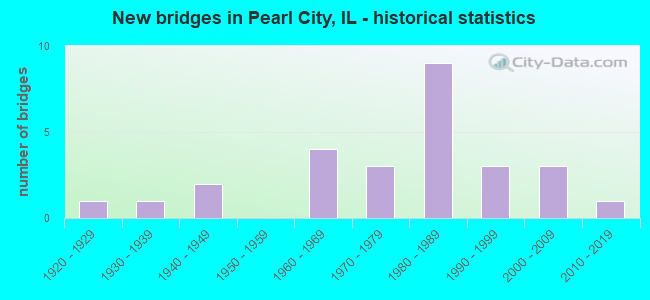
- New bridges - historical statistics
- 11920-1929
- 11930-1939
- 21940-1949
- 41960-1969
- 31970-1979
- 91980-1989
- 31990-1999
- 32000-2009
- 12010-2019

- Reconstructed bridges - Historical Statistics
- 11960-1969
- 01970-1979
- 01980-1989
- 21990-1999


- Bridge Condition - Deck
- 52.0%Very good
- 28.0%Good
- 8.0%Satisfactory
- 12.0%Fair

- Bridge Condition - Superstructure
- 52.0%Very good
- 28.0%Good
- 4.0%Satisfactory
- 16.0%Fair

- Bridge Condition - Substructure
- 40.0%Very good
- 52.0%Good
- 8.0%Satisfactory

- Bridge Condition - Channel
- 29.6%Very good
- 66.7%Good
- 3.7%Satisfactory

- Bridge Condition - Culverts
- 50.0%Good
- 50.0%Satisfactory
Find on map >> Show street view
Structure Number: 890053, Location: 3.2 MI SOUTH OF US20 (Lat: 42.312131, Lng: -89.827250), Route carried "on" structure: State highway 73, Year Built: 1985, Status: Open, Structure Length: 1.38m (4.53ft), Average Daily Traffic: 2,300 (year 2021), Truck Traffic: 16%, Average Future Daily Traffic: 3,000 (year 2040), Design Load: HS 20, Features Intersected: YELLOW CREEK
Minimum Vertical Clearance: 30+ m (98+ ft), Kilometerpoint: 24.220, Lanes on structure: 2, Base Highway Network: Yes, Owner: State Highway Agency, Approaching Roadway Width: 7.9m (25.9ft), Skew: 4 degrees, Material/Design: Steel, Design/Construction: Stringer/Multi-beam, Number Of Spans In Main Unit: 1, Length of Maximum Span: 13.4m (44.0ft), Curb-To-Curb Width: 9.8m (32.2ft), Out-to-Out Width: 10.7m (35.1ft)
Condition: Deck: Good, Superstructure: Good, Substructure: Good, Channel: Good, Operating Rating: 71.0 metric tons, Method Used To Determine Operating Rating: Load Factor (LF) rating reported by rating factor (RF) method using MS18 loading, Inventory Rating: 42.4 metric tons, Method Used To Determine Inventory Rating: Load Factor (LF) rating reported by rating factor (RF) method using MS18 loading, Structural Evaluation: Better than present minimum criteria, Deck Geometry: Meets minimum limits, Waterway Adequacy: Equal to present desirable criteria, Approach Roadway Alignment: Equal to present desirable criteria, Designated Inspection Frequency: Every 48 months, Inspection Date: April 2019, Deck Structure Type: Concrete Cast-file-Place, Wearing Surface/Protective System: Wearing Surface: Bituminous, Deck Protection: Epoxy Coated Reinforcing
Find on map >> Show street view
Structure Number: 890069, Location: 0.5 MI N PEARL CITY (Lat: 42.282167, Lng: -89.826569), Route carried "on" structure: State highway 73, Year Built: 1992, Status: Open, Structure Length: 4.10m (13.45ft), Average Daily Traffic: 2,550 (year 2021), Truck Traffic: 18%, Average Future Daily Traffic: 3,200 (year 2040), Design Load: HS 20, Features Intersected: YELLOW CREEK
Minimum Vertical Clearance: 30+ m (98+ ft), Kilometerpoint: 20.857, Lanes on structure: 2, Base Highway Network: Yes, Owner: State Highway Agency, Approaching Roadway Width: 11.0m (36.1ft), Material/Design: Prestressed concrete continuous, Design/Construction: Stringer/Multi-beam, Number Of Spans In Main Unit: 3, Length of Maximum Span: 15.8m (51.8ft), Curb-To-Curb Width: 11.2m (36.7ft), Out-to-Out Width: 12.2m (40.0ft)
Condition: Deck: Satisfactory, Superstructure: Very good, Substructure: Very good, Channel: Good, Operating Rating: 85.5 metric tons, Method Used To Determine Operating Rating: Load Factor (LF) rating reported by rating factor (RF) method using MS18 loading, Inventory Rating: 53.1 metric tons, Method Used To Determine Inventory Rating: Load Factor (LF) rating reported by rating factor (RF) method using MS18 loading, Structural Evaluation: Equal to present desirable criteria, Deck Geometry: Somewhat better than minimum adequacy, Waterway Adequacy: Equal to present desirable criteria, Approach Roadway Alignment: Equal to present desirable criteria, Designated Inspection Frequency: Every 48 months, Inspection Date: November 2021, Deck Structure Type: Concrete Cast-file-Place, Wearing Surface/Protective System: Deck Protection: Epoxy Coated Reinforcing
Find on map >> Show street view
Structure Number: 89007, Location: 1.5 MI S PEARL CITY (Lat: 42.240278, Lng: -89.825842), Route carried "on" structure: State highway 73, Year Built: 1992, Status: Open, Structure Length: 1.87m (6.14ft), Average Daily Traffic: 2,250 (year 2021), Truck Traffic: 19%, Average Future Daily Traffic: 2,800 (year 2040), Design Load: HS 20, Features Intersected: SPRING CREEK
Minimum Vertical Clearance: 30+ m (98+ ft), Kilometerpoint: 16.222, Lanes on structure: 2, Base Highway Network: Yes, Owner: State Highway Agency, Approaching Roadway Width: 7.9m (25.9ft), Material/Design: Prestressed concrete, Design/Construction: Stringer/Multi-beam, Number Of Spans In Main Unit: 1, Length of Maximum Span: 17.9m (58.7ft), Curb-To-Curb Width: 9.7m (31.8ft), Out-to-Out Width: 10.7m (35.1ft)
Condition: Deck: Satisfactory, Superstructure: Very good, Substructure: Very good, Channel: Very good, Operating Rating: 74.8 metric tons, Method Used To Determine Operating Rating: Load Factor (LF) rating reported by rating factor (RF) method using MS18 loading, Inventory Rating: 37.9 metric tons, Method Used To Determine Inventory Rating: Load Factor (LF) rating reported by rating factor (RF) method using MS18 loading, Structural Evaluation: Equal to present desirable criteria, Deck Geometry: Meets minimum limits, Waterway Adequacy: Equal to present desirable criteria, Approach Roadway Alignment: Equal to present desirable criteria, Designated Inspection Frequency: Every 48 months, Inspection Date: November 2021, Deck Structure Type: Concrete Cast-file-Place, Wearing Surface/Protective System: Deck Protection: Epoxy Coated Reinforcing
Find on map >> Show street view
Structure Number: 892017, Location: PEARL CITY (Lat: 42.269028, Lng: -89.826256), Route carried "on" structure: State highway 73, Year Built: 2002, Status: Open, Structure Length: 0.92m (3.02ft), Average Daily Traffic: 3,100 (year 2021), Truck Traffic: 13%, Average Future Daily Traffic: 6,100 (year 2040), Design Load: HS 20+Mod, Features Intersected: TRIB. YELLOW CREEK
Minimum Vertical Clearance: 30+ m (98+ ft), Kilometerpoint: 19.424, Lanes on structure: 2, Base Highway Network: Yes, Owner: State Highway Agency, Approaching Roadway Width: 11.0m (36.1ft), Material/Design: Concrete, Design/Construction: Culvert, Number Of Spans In Main Unit: 3, Length of Maximum Span: 2.9m (9.5ft), Curb or Sidewalk Widths: Left: 1.8m (5.9ft), Right: 1.8m (5.9ft), Out-to-Out Width: 15.2m (49.9ft)
Condition: Channel: Good, Culverts: Good, Operating Rating: 89.1 metric tons, Method Used To Determine Operating Rating: Load Factor (LF) rating reported by rating factor (RF) method using MS18 loading, Inventory Rating: 55.4 metric tons, Method Used To Determine Inventory Rating: Load Factor (LF) rating reported by rating factor (RF) method using MS18 loading, Structural Evaluation: Better than present minimum criteria, Waterway Adequacy: Equal to present minimum criteria, Approach Roadway Alignment: Equal to present desirable criteria, Designated Inspection Frequency: Every 48 months, Inspection Date: November 2018, Wearing Surface/Protective System: Deck Protection: Epoxy Coated Reinforcing
Find on map >> Show street view
Structure Number: 893017, Location: PEARL CITY (Lat: 42.267419, Lng: -89.824847), Route carried "on" structure: County highway , Year Built: 1940, Year Reconstructed: 2001, Status: Open, Structure Length: 1.16m (3.81ft), Average Daily Traffic: 2,650 (year 2019), Truck Traffic: 6%, Average Future Daily Traffic: 3,038 (year 2032), Design Load: HS 20, Features Intersected: YELLOW CR. BR., Facility Carried by Structure: PEARL CITY RD.
Minimum Vertical Clearance: 30+ m (98+ ft), Kilometerpoint: 0.113, Lanes on structure: 2, Base Highway Network: Yes, Owner: County Highway Agency, Approaching Roadway Width: 9.1m (29.9ft), Skew: 2 degrees, Material/Design: Concrete, Design/Construction: Channel Beam, Number Of Spans In Main Unit: 1, Length of Maximum Span: 11.3m (37.1ft), Curb-To-Curb Width: 9.1m (29.9ft), Out-to-Out Width: 9.1m (29.9ft)
Condition: Deck: Good, Superstructure: Fair, Substructure: Good, Channel: Very good, Operating Rating: 67.7 metric tons, Method Used To Determine Operating Rating: Load Factor (LF) rating reported by rating factor (RF) method using MS18 loading, Inventory Rating: 40.5 metric tons, Method Used To Determine Inventory Rating: Load Factor (LF) rating reported by rating factor (RF) method using MS18 loading, Structural Evaluation: Somewhat better than minimum adequacy, Deck Geometry: Meets minimum limits, Waterway Adequacy: Better than present minimum criteria, Approach Roadway Alignment: Equal to present desirable criteria, Length Of Structure Improvement: 1.16m (3.81ft), Designated Inspection Frequency: Every 24 months, Inspection Date: October 2021, Bridge Improvement Cost: $60,000, Roadway Improvement Cost: $6,000, Total Project Cost: $90,000, Deck Structure Type: Concrete Precast Panels, Wearing Surface/Protective System: Wearing Surface: Bituminous, Membrane: Built-up
Find on map >> Show street view
Structure Number: 893018, Location: EAST EDGE PEARL CITY (Lat: 42.267447, Lng: -89.821150), Route carried "on" structure: County highway , Year Built: 1940, Year Reconstructed: 2001, Status: Open, Structure Length: 8.35m (27.40ft), Average Daily Traffic: 2,650 (year 2019), Truck Traffic: 6%, Average Future Daily Traffic: 3,038 (year 2032), Design Load: HS 20, Features Intersected: YELLOW CREEK, Facility Carried by Structure: PEARL CITY RD.
Minimum Vertical Clearance: 30+ m (98+ ft), Kilometerpoint: 0.418, Lanes on structure: 2, Base Highway Network: Yes, Owner: County Highway Agency, Approaching Roadway Width: 9.1m (29.9ft), Skew: 2 degrees, Material/Design: Steel continuous, Design/Construction: Stringer/Multi-beam, Number Of Spans In Main Unit: 4, Length of Maximum Span: 22.9m (75.1ft), Curb or Sidewalk Widths: Left: 0.6m (2.0ft), Right: 0.6m (2.0ft), Curb-To-Curb Width: 9.1m (29.9ft), Out-to-Out Width: 9.1m (29.9ft)
Condition: Deck: Very good, Superstructure: Very good, Substructure: Very good, Channel: Good, Operating Rating: 44.4 metric tons, Method Used To Determine Operating Rating: Load Factor (LF) rating reported by rating factor (RF) method using MS18 loading, Inventory Rating: 32.4 metric tons, Method Used To Determine Inventory Rating: Load Factor (LF) rating reported by rating factor (RF) method using MS18 loading, Structural Evaluation: Equal to present desirable criteria, Deck Geometry: Meets minimum limits, Waterway Adequacy: Equal to present desirable criteria, Approach Roadway Alignment: Equal to present desirable criteria, Length Of Structure Improvement: 9.17m (30.09ft), Designated Inspection Frequency: Every 48 months, Inspection Date: October 2019, Bridge Improvement Cost: $675,000, Roadway Improvement Cost: $68,000, Total Project Cost: $1,013,000, Deck Structure Type: Concrete Cast-file-Place, Wearing Surface/Protective System: Deck Protection: Epoxy Coated Reinforcing
Find on map >> Show street view
Structure Number: 893019, Location: 3 MI. EAST PEARL CTY (Lat: 42.267139, Lng: -89.764517), Route carried "on" structure: County highway , Year Built: 1927, Year Reconstructed: 1965, Status: Open, Structure Length: 1.62m (5.31ft), Average Daily Traffic: 2,600 (year 2019), Truck Traffic: 8%, Average Future Daily Traffic: 3,472 (year 2032), Design Load: HS 20, Features Intersected: YELLOW CR BRANCH, Facility Carried by Structure: PEARL CITY RD
Minimum Vertical Clearance: 30+ m (98+ ft), Kilometerpoint: 5.101, Lanes on structure: 2, Base Highway Network: Yes, Owner: County Highway Agency, Approaching Roadway Width: 11.0m (36.1ft), Material/Design: Prestressed concrete, Design/Construction: Box Beam or Girders - Multiple, Number Of Spans In Main Unit: 1, Length of Maximum Span: 15.8m (51.8ft), Curb-To-Curb Width: 7.9m (25.9ft), Out-to-Out Width: 8.5m (27.9ft)
Condition: Deck: Very good, Superstructure: Very good, Substructure: Satisfactory, Channel: Good, Operating Rating: 44.4 metric tons, Method Used To Determine Operating Rating: Load Factor (LF) rating reported by rating factor (RF) method using MS18 loading, Inventory Rating: 32.4 metric tons, Method Used To Determine Inventory Rating: Load Factor (LF) rating reported by rating factor (RF) method using MS18 loading, Structural Evaluation: Equal to present minimum criteria, Deck Geometry: High priority of corrective action, Waterway Adequacy: Equal to present desirable criteria, Approach Roadway Alignment: Equal to present desirable criteria, Length Of Structure Improvement: 2.26m (7.41ft), Designated Inspection Frequency: Every 24 months, Inspection Date: October 2021, Bridge Improvement Cost: $131,000, Roadway Improvement Cost: $13,000, Total Project Cost: $197,000, Deck Structure Type: Concrete Precast Panels, Wearing Surface/Protective System: Wearing Surface: Bituminous
Find on map >> Show street view
Structure Number: 89302, Location: 2 MI. N. PEARL CTY (Lat: 42.303117, Lng: -89.834742), Route carried "on" structure: County highway , Year Built: 1966, Status: Open, Structure Length: 0.98m (3.22ft), Average Daily Traffic: 575 (year 2019), Truck Traffic: 12%, Average Future Daily Traffic: 700 (year 2040), Design Load: H 20, Features Intersected: YELLOW CR BRANCH, Facility Carried by Structure: DUBLIN RD.
Minimum Vertical Clearance: 30+ m (98+ ft), Kilometerpoint: 0.708, Lanes on structure: 2, Owner: County Highway Agency, Approaching Roadway Width: 11.0m (36.1ft), Material/Design: Concrete, Design/Construction: Slab, Number Of Spans In Main Unit: 1, Length of Maximum Span: 9.1m (29.9ft), Curb-To-Curb Width: 8.5m (27.9ft), Out-to-Out Width: 9.8m (32.2ft)
Condition: Deck: Good, Superstructure: Good, Substructure: Good, Channel: Good, Operating Rating: 65.1 metric tons, Method Used To Determine Operating Rating: Allowable Stress (AS) rating reported by rating factor (RF) method using MS18 loading, Inventory Rating: 39.2 metric tons, Method Used To Determine Inventory Rating: Allowable Stress (AS) rating reported by rating factor (RF) method using MS18 loading, Structural Evaluation: Better than present minimum criteria, Deck Geometry: Somewhat better than minimum adequacy, Waterway Adequacy: Equal to present desirable criteria, Approach Roadway Alignment: Equal to present desirable criteria, Designated Inspection Frequency: Every 24 months, Inspection Date: September 2021, Deck Structure Type: Concrete Cast-file-Place
Find on map >> Show street view
Structure Number: 893021, Location: 2.5 MI NW PEARL CITY (Lat: 42.304656, Lng: -89.852736), Route carried "on" structure: County highway , Year Built: 1966, Status: Open, Structure Length: 3.99m (13.09ft), Average Daily Traffic: 575 (year 2019), Truck Traffic: 12%, Average Future Daily Traffic: 700 (year 2040), Design Load: H 20, Features Intersected: YELLOW CREEK, Facility Carried by Structure: DUBLIN RD.
Minimum Vertical Clearance: 30+ m (98+ ft), Kilometerpoint: 2.253, Lanes on structure: 2, Owner: County Highway Agency, Approaching Roadway Width: 11.0m (36.1ft), Skew: 1 degrees, Material/Design: Steel continuous, Design/Construction: Stringer/Multi-beam, Number Of Spans In Main Unit: 3, Length of Maximum Span: 14.3m (46.9ft), Curb-To-Curb Width: 7.9m (25.9ft), Out-to-Out Width: 9.3m (30.5ft)
Condition: Deck: Fair, Superstructure: Fair, Substructure: Good, Channel: Good, Operating Rating: 53.5 metric tons, Method Used To Determine Operating Rating: Load Factor (LF) rating reported by rating factor (RF) method using MS18 loading, Inventory Rating: 32.1 metric tons, Method Used To Determine Inventory Rating: Load Factor (LF) rating reported by rating factor (RF) method using MS18 loading, Structural Evaluation: Somewhat better than minimum adequacy, Deck Geometry: Somewhat better than minimum adequacy, Waterway Adequacy: Better than present minimum criteria, Approach Roadway Alignment: Better than present minimum criteria, Designated Inspection Frequency: Every 24 months, Inspection Date: September 2021, Deck Structure Type: Concrete Cast-file-Place
Find on map >> Show street view
Structure Number: 893145, Location: 1.4 MI W OF ILL 73 (Lat: 42.312933, Lng: -89.853703), Route carried "on" structure: County highway , Year Built: 1965, Status: Open, Structure Length: 2.44m (8.01ft), Average Daily Traffic: 75 (year 2019), Average Future Daily Traffic: 25 (year 2040), Design Load: HS 15, Features Intersected: BR OF YELLOW CREEK, Facility Carried by Structure: WEST RADERS ROAD
Minimum Vertical Clearance: 30+ m (98+ ft), Kilometerpoint: 0.853, Lanes on structure: 2, Owner: Town or Township Highway Agency, Approaching Roadway Width: 6.7m (22.0ft), Material/Design: Concrete, Design/Construction: Slab, Number Of Spans In Main Unit: 3, Length of Maximum Span: 9.1m (29.9ft), Curb-To-Curb Width: 7.3m (24.0ft), Out-to-Out Width: 8.6m (28.2ft)
Condition: Deck: Fair, Superstructure: Fair, Substructure: Satisfactory, Channel: Good, Operating Rating: 42.8 metric tons, Method Used To Determine Operating Rating: Load Factor (LF) rating reported by rating factor (RF) method using MS18 loading, Inventory Rating: 25.6 metric tons, Method Used To Determine Inventory Rating: Load Factor (LF) rating reported by rating factor (RF) method using MS18 loading, Structural Evaluation: Somewhat better than minimum adequacy, Deck Geometry: Equal to present minimum criteria, Waterway Adequacy: Equal to present minimum criteria, Approach Roadway Alignment: Equal to present desirable criteria, Designated Inspection Frequency: Every 24 months, Inspection Date: September 2021, Deck Structure Type: Concrete Cast-file-Place
Find on map >> Show street view
Structure Number: 893187, Location: 3 MI SE PEARL CITY (Lat: 42.248897, Lng: -89.776075), Route carried "on" structure: County highway , Year Built: 1931, Status: Posted for load, Structure Length: 2.56m (8.40ft), Average Daily Traffic: 100 (year 2019), Truck Traffic: 19%, Average Future Daily Traffic: 100 (year 2040), Design Load: H 15, Features Intersected: YELLOW CREEK, Facility Carried by Structure: S MILL GROVE ROAD
Minimum Vertical Clearance: 30+ m (98+ ft), Kilometerpoint: 0.998, Lanes on structure: 2, Owner: Town or Township Highway Agency, Approaching Roadway Width: 7.3m (24.0ft), Material/Design: Steel, Design/Construction: Truss - Thru, Number Of Spans In Main Unit: 1, Length of Maximum Span: 24.4m (80.1ft), Curb-To-Curb Width: 7.0m (23.0ft), Out-to-Out Width: 7.0m (23.0ft)
Condition: Deck: Fair, Superstructure: Fair, Substructure: Good, Channel: Very good, Operating Rating: 20.7 metric tons, Method Used To Determine Operating Rating: Allowable Stress (AS) rating reported by rating factor (RF) method using MS18 loading, Inventory Rating: 11.7 metric tons, Method Used To Determine Inventory Rating: Allowable Stress (AS) rating reported by rating factor (RF) method using MS18 loading, Structural Evaluation: Meets minimum limits, Deck Geometry: Somewhat better than minimum adequacy, Waterway Adequacy: Equal to present desirable criteria, Approach Roadway Alignment: Meets minimum limits, Bridge Posting: Required (Relationship of Operating Rating to Maximum Legal Load: > 39.9% below), Designated Inspection Frequency: Every 24 months, Critical Feature Inspection Frequency: Every 24 months, Inspection Date: December 2021, Critical Feature Inspection Date: October 2020, Deck Structure Type: Concrete Cast-file-Place
Find on map >> Show street view
Structure Number: 893216, Location: .56 MI S PEARL C RD (Lat: 42.260778, Lng: -89.761658), Route carried "on" structure: County highway , Year Built: 1978, Status: Open, Structure Length: 2.26m (7.41ft), Average Daily Traffic: 50 (year 2020), Average Future Daily Traffic: 100 (year 2040), Design Load: HS 20, Features Intersected: BR OF YELLOW CREEK, Facility Carried by Structure: W BLOCK ROAD
Minimum Vertical Clearance: 30+ m (98+ ft), Kilometerpoint: 6.180, Lanes on structure: 2, Owner: Town or Township Highway Agency, Approaching Roadway Width: 8.5m (27.9ft), Skew: 2 degrees, Material/Design: Concrete, Design/Construction: Slab, Number Of Spans In Main Unit: 3, Length of Maximum Span: 8.2m (26.9ft), Curb-To-Curb Width: 7.3m (24.0ft), Out-to-Out Width: 8.1m (26.6ft)
Condition: Deck: Good, Superstructure: Very good, Substructure: Good, Channel: Good, Operating Rating: 44.4 metric tons, Method Used To Determine Operating Rating: Assigned rating based on Load Factor Design (LFD) reported by rating factor (RF) using MS18 loading, Inventory Rating: 32.4 metric tons, Method Used To Determine Inventory Rating: Assigned rating based on Load Factor Design (LFD) reported by rating factor (RF) using MS18 loading, Structural Evaluation: Better than present minimum criteria, Deck Geometry: Equal to present minimum criteria, Waterway Adequacy: Equal to present desirable criteria, Approach Roadway Alignment: Equal to present desirable criteria, Designated Inspection Frequency: Every 48 months, Inspection Date: September 2021, Deck Structure Type: Concrete Cast-file-Place
Find on map >> Show street view
Structure Number: 893221, Location: 1.1 MI E OF ILL 73 (Lat: 42.241992, Lng: -89.803869), Route carried "on" structure: County highway , Year Built: 1980, Status: Open, Structure Length: 1.46m (4.79ft), Average Daily Traffic: 125 (year 2019), Truck Traffic: 33%, Average Future Daily Traffic: 100 (year 2040), Design Load: HS 20, Features Intersected: SPRING BRANCH, Facility Carried by Structure: WEST LORAN ROAD
Minimum Vertical Clearance: 30+ m (98+ ft), Kilometerpoint: 1.819, Lanes on structure: 2, Owner: Town or Township Highway Agency, Approaching Roadway Width: 8.5m (27.9ft), Material/Design: Prestressed concrete, Design/Construction: Box Beam or Girders - Multiple, Number Of Spans In Main Unit: 1, Length of Maximum Span: 14.0m (45.9ft), Curb-To-Curb Width: 7.3m (24.0ft), Out-to-Out Width: 7.3m (24.0ft)
Condition: Deck: Good, Superstructure: Good, Substructure: Good, Channel: Satisfactory, Operating Rating: 44.4 metric tons, Method Used To Determine Operating Rating: Assigned rating based on Load Factor Design (LFD) reported by rating factor (RF) using MS18 loading, Inventory Rating: 32.4 metric tons, Method Used To Determine Inventory Rating: Assigned rating based on Load Factor Design (LFD) reported by rating factor (RF) using MS18 loading, Structural Evaluation: Better than present minimum criteria, Deck Geometry: Somewhat better than minimum adequacy, Waterway Adequacy: Better than present minimum criteria, Approach Roadway Alignment: Equal to present desirable criteria, Designated Inspection Frequency: Every 48 months, Inspection Date: September 2021, Deck Structure Type: Concrete Precast Panels
Find on map >> Show street view
Structure Number: 893226, Location: 3.0 M SE PEARL CITY (Lat: 42.243572, Lng: -89.776997), Route carried "on" structure: County highway , Year Built: 1979, Status: Open, Structure Length: 3.63m (11.91ft), Average Daily Traffic: 100 (year 2019), Truck Traffic: 19%, Average Future Daily Traffic: 100 (year 2040), Design Load: HS 20, Features Intersected: LOST CREEK, Facility Carried by Structure: S MILL GROVE ROAD
Minimum Vertical Clearance: 30+ m (98+ ft), Kilometerpoint: 1.658, Lanes on structure: 2, Owner: Town or Township Highway Agency, Approaching Roadway Width: 6.7m (22.0ft), Skew: 3 degrees, Material/Design: Prestressed concrete, Design/Construction: Box Beam or Girders - Multiple, Number Of Spans In Main Unit: 3, Length of Maximum Span: 11.9m (39.0ft), Curb-To-Curb Width: 7.3m (24.0ft), Out-to-Out Width: 7.3m (24.0ft)
Condition: Deck: Very good, Superstructure: Good, Substructure: Good, Channel: Good, Operating Rating: 44.4 metric tons, Method Used To Determine Operating Rating: Assigned rating based on Load Factor Design (LFD) reported by rating factor (RF) using MS18 loading, Inventory Rating: 32.4 metric tons, Method Used To Determine Inventory Rating: Assigned rating based on Load Factor Design (LFD) reported by rating factor (RF) using MS18 loading, Structural Evaluation: Better than present minimum criteria, Deck Geometry: Equal to present minimum criteria, Waterway Adequacy: Better than present minimum criteria, Approach Roadway Alignment: Equal to present desirable criteria, Designated Inspection Frequency: Every 48 months, Inspection Date: December 2019, Deck Structure Type: Concrete Precast Panels, Wearing Surface/Protective System: Wearing Surface: Bituminous, Membrane: Built-up
Find on map >> Show street view
Structure Number: 893227, Location: 1.6 M W OF ILL 73 (Lat: 42.311992, Lng: -89.857708), Route carried "on" structure: County highway , Year Built: 1979, Status: Open, Structure Length: 1.40m (4.59ft), Average Daily Traffic: 25 (year 2020), Average Future Daily Traffic: 50 (year 2040), Design Load: HS 20, Features Intersected: YELLOW CREEK, Facility Carried by Structure: WEST RADERS ROAD
Minimum Vertical Clearance: 30+ m (98+ ft), Kilometerpoint: 0.467, Lanes on structure: 2, Owner: Town or Township Highway Agency, Approaching Roadway Width: 7.3m (24.0ft), Material/Design: Prestressed concrete, Design/Construction: Box Beam or Girders - Multiple, Number Of Spans In Main Unit: 1, Length of Maximum Span: 13.4m (44.0ft), Curb-To-Curb Width: 7.9m (25.9ft), Out-to-Out Width: 7.9m (25.9ft)
Condition: Deck: Very good, Superstructure: Good, Substructure: Good, Channel: Good, Operating Rating: 44.4 metric tons, Method Used To Determine Operating Rating: Assigned rating based on Load Factor Design (LFD) reported by rating factor (RF) using MS18 loading, Inventory Rating: 32.4 metric tons, Method Used To Determine Inventory Rating: Assigned rating based on Load Factor Design (LFD) reported by rating factor (RF) using MS18 loading, Structural Evaluation: Better than present minimum criteria, Deck Geometry: Equal to present minimum criteria, Waterway Adequacy: Equal to present desirable criteria, Approach Roadway Alignment: Equal to present desirable criteria, Designated Inspection Frequency: Every 48 months, Inspection Date: September 2019, Deck Structure Type: Concrete Precast Panels
Find on map >> Show street view
Structure Number: 89323, Location: 2.0 MI SE PEARL CITY (Lat: 42.242728, Lng: -89.801386), Route carried "on" structure: County highway , Year Built: 1980, Status: Open, Structure Length: 1.46m (4.79ft), Average Daily Traffic: 25 (year 2020), Average Future Daily Traffic: 25 (year 2040), Design Load: HS 20, Features Intersected: SPRING BRANCH, Facility Carried by Structure: S SCHUMAN ROAD
Minimum Vertical Clearance: 30+ m (98+ ft), Kilometerpoint: 1.143, Lanes on structure: 2, Owner: Town or Township Highway Agency, Approaching Roadway Width: 8.5m (27.9ft), Material/Design: Prestressed concrete, Design/Construction: Box Beam or Girders - Multiple, Number Of Spans In Main Unit: 1, Length of Maximum Span: 13.7m (44.9ft), Curb-To-Curb Width: 7.3m (24.0ft), Out-to-Out Width: 7.3m (24.0ft)
Condition: Deck: Very good, Superstructure: Good, Substructure: Very good, Channel: Good, Operating Rating: 44.4 metric tons, Method Used To Determine Operating Rating: Assigned rating based on Load Factor Design (LFD) reported by rating factor (RF) using MS18 loading, Inventory Rating: 32.4 metric tons, Method Used To Determine Inventory Rating: Assigned rating based on Load Factor Design (LFD) reported by rating factor (RF) using MS18 loading, Structural Evaluation: Better than present minimum criteria, Deck Geometry: Equal to present minimum criteria, Waterway Adequacy: Equal to present desirable criteria, Approach Roadway Alignment: Equal to present desirable criteria, Designated Inspection Frequency: Every 48 months, Inspection Date: December 2019, Deck Structure Type: Concrete Precast Panels
Find on map >> Show street view
Structure Number: 893234, Location: 3.0 MI E PEARL CITY (Lat: 42.278531, Lng: -89.766072), Route carried "on" structure: County highway , Year Built: 1982, Status: Open, Structure Length: 1.31m (4.30ft), Average Daily Traffic: 150 (year 2019), Truck Traffic: 15%, Average Future Daily Traffic: 200 (year 2040), Design Load: HS 20, Features Intersected: YELLOW CREEK BRANCH, Facility Carried by Structure: W BABBS GROVE ROAD
Minimum Vertical Clearance: 30+ m (98+ ft), Kilometerpoint: 5.359, Lanes on structure: 2, Owner: Town or Township Highway Agency, Approaching Roadway Width: 5.9m (19.4ft), Material/Design: Prestressed concrete, Design/Construction: Box Beam or Girders - Multiple, Number Of Spans In Main Unit: 1, Length of Maximum Span: 12.2m (40.0ft), Curb-To-Curb Width: 7.3m (24.0ft), Out-to-Out Width: 7.3m (24.0ft)
Condition: Deck: Good, Superstructure: Good, Substructure: Good, Channel: Good, Operating Rating: 44.4 metric tons, Method Used To Determine Operating Rating: Assigned rating based on Load Factor Design (LFD) reported by rating factor (RF) using MS18 loading, Inventory Rating: 32.4 metric tons, Method Used To Determine Inventory Rating: Assigned rating based on Load Factor Design (LFD) reported by rating factor (RF) using MS18 loading, Structural Evaluation: Better than present minimum criteria, Deck Geometry: Somewhat better than minimum adequacy, Waterway Adequacy: Equal to present desirable criteria, Approach Roadway Alignment: Equal to present desirable criteria, Designated Inspection Frequency: Every 48 months, Inspection Date: October 2019, Deck Structure Type: Concrete Precast Panels
Find on map >> Show street view
Structure Number: 893236, Location: 0.1 MI E OF ILL 73 (Lat: 42.313131, Lng: -89.826486), Route carried "on" structure: County highway , Year Built: 1981, Status: Open, Structure Length: 0.98m (3.22ft), Average Daily Traffic: 50 (year 2019), Truck Traffic: 22%, Average Future Daily Traffic: 50 (year 2040), Design Load: HS 20, Features Intersected: BR OF YELLOW CREEK, Facility Carried by Structure: W RADERS ROAD
Minimum Vertical Clearance: 30+ m (98+ ft), Kilometerpoint: 3.090, Lanes on structure: 2, Owner: Town or Township Highway Agency, Approaching Roadway Width: 7.3m (24.0ft), Skew: 1 degrees, Material/Design: Prestressed concrete, Design/Construction: Box Beam or Girders - Multiple, Number Of Spans In Main Unit: 1, Length of Maximum Span: 8.8m (28.9ft), Curb-To-Curb Width: 7.3m (24.0ft), Out-to-Out Width: 7.3m (24.0ft)
Condition: Deck: Good, Superstructure: Satisfactory, Substructure: Good, Channel: Good, Operating Rating: 44.4 metric tons, Method Used To Determine Operating Rating: Assigned rating based on Load Factor Design (LFD) reported by rating factor (RF) using MS18 loading, Inventory Rating: 32.4 metric tons, Method Used To Determine Inventory Rating: Assigned rating based on Load Factor Design (LFD) reported by rating factor (RF) using MS18 loading, Structural Evaluation: Equal to present minimum criteria, Deck Geometry: Equal to present minimum criteria, Waterway Adequacy: Equal to present desirable criteria, Approach Roadway Alignment: Equal to present desirable criteria, Designated Inspection Frequency: Every 24 months, Inspection Date: September 2021, Deck Structure Type: Concrete Precast Panels
Find on map >> Show street view
Structure Number: 893244, Location: 1.5 MI NE PEARL CITY (Lat: 42.290744, Lng: -89.807175), Route carried "on" structure: County highway , Year Built: 1982, Status: Open, Structure Length: 1.58m (5.18ft), Average Daily Traffic: 50 (year 2020), Average Future Daily Traffic: 50 (year 2040), Design Load: HS 20, Features Intersected: BR OF YELLOW CREEK, Facility Carried by Structure: SOUTH REES ROAD
Minimum Vertical Clearance: 30+ m (98+ ft), Kilometerpoint: 1.706, Lanes on structure: 2, Owner: Town or Township Highway Agency, Approaching Roadway Width: 6.1m (20.0ft), Skew: 3 degrees, Material/Design: Prestressed concrete, Design/Construction: Box Beam or Girders - Multiple, Number Of Spans In Main Unit: 1, Length of Maximum Span: 14.9m (48.9ft), Curb-To-Curb Width: 7.3m (24.0ft), Out-to-Out Width: 7.3m (24.0ft)
Condition: Deck: Very good, Superstructure: Very good, Substructure: Good, Channel: Good, Operating Rating: 44.4 metric tons, Method Used To Determine Operating Rating: Assigned rating based on Load Factor Design (LFD) reported by rating factor (RF) using MS18 loading, Inventory Rating: 32.4 metric tons, Method Used To Determine Inventory Rating: Assigned rating based on Load Factor Design (LFD) reported by rating factor (RF) using MS18 loading, Structural Evaluation: Better than present minimum criteria, Deck Geometry: Equal to present minimum criteria, Waterway Adequacy: Equal to present desirable criteria, Approach Roadway Alignment: Equal to present desirable criteria, Designated Inspection Frequency: Every 48 months, Inspection Date: September 2019, Deck Structure Type: Concrete Precast Panels
Find on map >> Show street view
Structure Number: 893245, Location: 3 MI WEST PEARL CITY (Lat: 42.265417, Lng: -89.892089), Route carried "on" structure: County highway , Year Built: 1984, Status: Open, Structure Length: 1.71m (5.61ft), Average Daily Traffic: 50 (year 2020), Average Future Daily Traffic: 50 (year 2040), Design Load: HS 20, Features Intersected: EAST PLUM RIVER, Facility Carried by Structure: W DITZLER ROAD
Minimum Vertical Clearance: 30+ m (98+ ft), Kilometerpoint: 0.161, Lanes on structure: 2, Owner: Town or Township Highway Agency, Approaching Roadway Width: 7.3m (24.0ft), Skew: 2 degrees, Material/Design: Prestressed concrete, Design/Construction: Box Beam or Girders - Multiple, Number Of Spans In Main Unit: 1, Length of Maximum Span: 16.2m (53.1ft), Curb-To-Curb Width: 7.3m (24.0ft), Out-to-Out Width: 7.6m (24.9ft)
Condition: Deck: Very good, Superstructure: Very good, Substructure: Good, Channel: Good, Operating Rating: 44.4 metric tons, Method Used To Determine Operating Rating: Assigned rating based on Load Factor Design (LFD) reported by rating factor (RF) using MS18 loading, Inventory Rating: 32.4 metric tons, Method Used To Determine Inventory Rating: Assigned rating based on Load Factor Design (LFD) reported by rating factor (RF) using MS18 loading, Structural Evaluation: Better than present minimum criteria, Deck Geometry: Equal to present minimum criteria, Waterway Adequacy: Equal to present desirable criteria, Approach Roadway Alignment: Equal to present desirable criteria, Designated Inspection Frequency: Every 48 months, Inspection Date: December 2019, Deck Structure Type: Concrete Precast Panels, Wearing Surface/Protective System: Wearing Surface: Bituminous, Membrane: Built-up
Find on map >> Show street view
Structure Number: 893247, Location: 1.6 MI E OF ILL 73 (Lat: 42.253842, Lng: -89.792172), Route carried "on" structure: County highway , Year Built: 1985, Status: Open, Structure Length: 3.96m (12.99ft), Average Daily Traffic: 50 (year 2020), Average Future Daily Traffic: 50 (year 2040), Design Load: HS 20, Features Intersected: YELLOW CREEK, Facility Carried by Structure: W BLOCK ROAD
Minimum Vertical Clearance: 30+ m (98+ ft), Kilometerpoint: 3.170, Lanes on structure: 2, Owner: Town or Township Highway Agency, Approaching Roadway Width: 7.3m (24.0ft), Material/Design: Prestressed concrete, Design/Construction: Box Beam or Girders - Multiple, Number Of Spans In Main Unit: 3, Length of Maximum Span: 13.1m (43.0ft), Curb-To-Curb Width: 7.3m (24.0ft), Out-to-Out Width: 7.3m (24.0ft)
Condition: Deck: Very good, Superstructure: Very good, Substructure: Very good, Channel: Very good, Operating Rating: 44.4 metric tons, Method Used To Determine Operating Rating: Assigned rating based on Load Factor Design (LFD) reported by rating factor (RF) using MS18 loading, Inventory Rating: 32.4 metric tons, Method Used To Determine Inventory Rating: Assigned rating based on Load Factor Design (LFD) reported by rating factor (RF) using MS18 loading, Structural Evaluation: Equal to present desirable criteria, Deck Geometry: Equal to present minimum criteria, Waterway Adequacy: Equal to present desirable criteria, Approach Roadway Alignment: Equal to present desirable criteria, Designated Inspection Frequency: Every 48 months, Inspection Date: December 2019, Deck Structure Type: Concrete Precast Panels, Wearing Surface/Protective System: Wearing Surface: Bituminous, Membrane: Built-up
Find on map >> Show street view
Structure Number: 893255, Location: 4 MI SW PEARL CITY (Lat: 42.211197, Lng: -89.871969), Route carried "on" structure: County highway , Year Built: 1988, Status: Open, Structure Length: 1.83m (6.00ft), Average Daily Traffic: 50 (year 2020), Average Future Daily Traffic: 50 (year 2040), Design Load: HS 20, Features Intersected: BR OF E PLUM RIVER, Facility Carried by Structure: W HERSHEY ROAD
Minimum Vertical Clearance: 30+ m (98+ ft), Kilometerpoint: 0.692, Lanes on structure: 2, Owner: Town or Township Highway Agency, Approaching Roadway Width: 7.3m (24.0ft), Material/Design: Prestressed concrete, Design/Construction: Box Beam or Girders - Multiple, Number Of Spans In Main Unit: 1, Length of Maximum Span: 18.0m (59.1ft), Curb-To-Curb Width: 7.3m (24.0ft), Out-to-Out Width: 7.3m (24.0ft)
Condition: Deck: Very good, Superstructure: Very good, Substructure: Very good, Channel: Good, Operating Rating: 44.4 metric tons, Method Used To Determine Operating Rating: Assigned rating based on Load Factor Design (LFD) reported by rating factor (RF) using MS18 loading, Inventory Rating: 32.4 metric tons, Method Used To Determine Inventory Rating: Assigned rating based on Load Factor Design (LFD) reported by rating factor (RF) using MS18 loading, Structural Evaluation: Equal to present desirable criteria, Deck Geometry: Equal to present minimum criteria, Waterway Adequacy: Equal to present desirable criteria, Approach Roadway Alignment: Equal to present desirable criteria, Designated Inspection Frequency: Every 48 months, Inspection Date: December 2019, Deck Structure Type: Concrete Precast Panels, Wearing Surface/Protective System: Wearing Surface: Bituminous, Membrane: Built-up
Find on map >> Show street view
Structure Number: 893275, Location: 0.75 MI W OF IL 73 (Lat: 42.201569, Lng: -89.838219), Route carried "on" structure: County highway , Year Built: 1998, Status: Open, Structure Length: 1.26m (4.13ft), Average Daily Traffic: 50 (year 2019), Average Future Daily Traffic: 50 (year 2040), Design Load: HS 20, Features Intersected: BR OF E FK E PLUM, Facility Carried by Structure: WEST LOTT ROAD
Minimum Vertical Clearance: 30+ m (98+ ft), Kilometerpoint: 8.240, Lanes on structure: 2, Owner: Town or Township Highway Agency, Approaching Roadway Width: 6.1m (20.0ft), Material/Design: Prestressed concrete, Design/Construction: Box Beam or Girders - Multiple, Number Of Spans In Main Unit: 1, Length of Maximum Span: 11.8m (38.7ft), Curb-To-Curb Width: 7.3m (24.0ft), Out-to-Out Width: 7.3m (24.0ft)
Condition: Deck: Very good, Superstructure: Very good, Substructure: Very good, Channel: Very good, Operating Rating: 44.1 metric tons, Method Used To Determine Operating Rating: Assigned rating based on Load Factor Design (LFD) reported by rating factor (RF) using MS18 loading, Inventory Rating: 32.4 metric tons, Method Used To Determine Inventory Rating: Assigned rating based on Load Factor Design (LFD) reported by rating factor (RF) using MS18 loading, Structural Evaluation: Equal to present desirable criteria, Deck Geometry: Equal to present minimum criteria, Waterway Adequacy: Equal to present desirable criteria, Approach Roadway Alignment: Equal to present desirable criteria, Designated Inspection Frequency: Every 48 months, Inspection Date: September 2021, Deck Structure Type: Concrete Precast Panels, Wearing Surface/Protective System: Wearing Surface: Bituminous, Membrane: Built-up
Find on map >> Show street view
Structure Number: 893277, Location: 200' S OF LORAN RD (Lat: 42.241653, Lng: -89.806319), Route carried "on" structure: County highway , Year Built: 2000, Status: Open, Structure Length: 1.47m (4.82ft), Average Daily Traffic: 50 (year 2014), Average Future Daily Traffic: 50 (year 2040), Design Load: HS 20, Features Intersected: SPRING BRANCH, Facility Carried by Structure: SOUTH SCHUMAN ROAD
Minimum Vertical Clearance: 30+ m (98+ ft), Kilometerpoint: 0.032, Lanes on structure: 2, Owner: Town or Township Highway Agency, Approaching Roadway Width: 7.3m (24.0ft), Material/Design: Prestressed concrete, Design/Construction: Box Beam or Girders - Multiple, Number Of Spans In Main Unit: 1, Length of Maximum Span: 14.3m (46.9ft), Curb-To-Curb Width: 7.3m (24.0ft), Out-to-Out Width: 7.3m (24.0ft)
Condition: Deck: Very good, Superstructure: Very good, Substructure: Very good, Channel: Very good, Operating Rating: 44.1 metric tons, Method Used To Determine Operating Rating: Assigned rating based on Load Factor Design (LFD) reported by rating factor (RF) using MS18 loading, Inventory Rating: 32.4 metric tons, Method Used To Determine Inventory Rating: Assigned rating based on Load Factor Design (LFD) reported by rating factor (RF) using MS18 loading, Structural Evaluation: Equal to present desirable criteria, Deck Geometry: Equal to present minimum criteria, Waterway Adequacy: Equal to present desirable criteria, Approach Roadway Alignment: Equal to present desirable criteria, Designated Inspection Frequency: Every 48 months, Inspection Date: December 2019, Deck Structure Type: Concrete Precast Panels, Wearing Surface/Protective System: Wearing Surface: Bituminous, Membrane: Built-up
Find on map >> Show street view
Structure Number: 893278, Location: 4.0 MI SW PEARL CITY (Lat: 42.215411, Lng: -89.860914), Route carried "on" structure: County highway , Year Built: 2002, Status: Open, Structure Length: 2.22m (7.28ft), Average Daily Traffic: 75 (year 2014), Average Future Daily Traffic: 50 (year 2040), Design Load: HS 20, Features Intersected: BR OF E PLUM RIVER, Facility Carried by Structure: SOUTH KOCH ROAD
Minimum Vertical Clearance: 30+ m (98+ ft), Kilometerpoint: 3.025, Lanes on structure: 2, Owner: Town or Township Highway Agency, Approaching Roadway Width: 7.3m (24.0ft), Skew: 4 degrees, Material/Design: Prestressed concrete, Design/Construction: Box Beam or Girders - Multiple, Number Of Spans In Main Unit: 1, Length of Maximum Span: 9.8m (32.2ft), Curb-To-Curb Width: 7.3m (24.0ft), Out-to-Out Width: 7.3m (24.0ft)
Condition: Deck: Very good, Superstructure: Very good, Substructure: Very good, Channel: Very good, Operating Rating: 44.1 metric tons, Method Used To Determine Operating Rating: Assigned rating based on Load Factor Design (LFD) reported by rating factor (RF) using MS18 loading, Inventory Rating: 32.4 metric tons, Method Used To Determine Inventory Rating: Assigned rating based on Load Factor Design (LFD) reported by rating factor (RF) using MS18 loading, Structural Evaluation: Equal to present desirable criteria, Deck Geometry: Equal to present minimum criteria, Waterway Adequacy: Equal to present desirable criteria, Approach Roadway Alignment: Better than present minimum criteria, Designated Inspection Frequency: Every 48 months, Inspection Date: December 2019, Deck Structure Type: Concrete Precast Panels, Wearing Surface/Protective System: Wearing Surface: Bituminous, Membrane: Built-up
Find on map >> Show street view
Structure Number: 893281, Location: 3 MI. WEST PEARL CTY (Lat: 42.274939, Lng: -89.885153), Route carried "on" structure: County highway , Year Built: 2010, Status: Open, Structure Length: 2.38m (7.81ft), Average Daily Traffic: 625 (year 2019), Truck Traffic: 6%, Average Future Daily Traffic: 450 (year 2040), Design Load: HS 20, Features Intersected: E PLUM RIVER, Facility Carried by Structure: GOLD MINE RD
Minimum Vertical Clearance: 30+ m (98+ ft), Kilometerpoint: 1.062, Lanes on structure: 2, Owner: County Highway Agency, Approaching Roadway Width: 6.8m (22.3ft), Material/Design: Concrete continuous, Design/Construction: Slab, Number Of Spans In Main Unit: 3, Length of Maximum Span: 8.2m (26.9ft), Curb-To-Curb Width: 9.1m (29.9ft), Out-to-Out Width: 9.1m (29.9ft)
Condition: Deck: Very good, Superstructure: Very good, Substructure: Very good, Channel: Very good, Operating Rating: 53.8 metric tons, Method Used To Determine Operating Rating: Assigned rating based on Load Factor Design (LFD) reported by rating factor (RF) using MS18 loading, Inventory Rating: 32.4 metric tons, Method Used To Determine Inventory Rating: Assigned rating based on Load Factor Design (LFD) reported by rating factor (RF) using MS18 loading, Structural Evaluation: Equal to present desirable criteria, Deck Geometry: Equal to present minimum criteria, Waterway Adequacy: Equal to present desirable criteria, Approach Roadway Alignment: Equal to present desirable criteria, Designated Inspection Frequency: Every 48 months, Inspection Date: December 2019, Deck Structure Type: Concrete Cast-file-Place, Wearing Surface/Protective System: Deck Protection: Epoxy Coated Reinforcing
Find on map >> Show street view
Structure Number: 895013, Location: 2.5 MI. E. IL. RT 73 (Lat: 42.227289, Lng: -89.776639), Route carried "on" structure: County highway , Year Built: 1967, Status: Open, Structure Length: 1.11m (3.64ft), Average Daily Traffic: 300 (year 2019), Truck Traffic: 8%, Average Future Daily Traffic: 400 (year 2040), Design Load: HS 20, Features Intersected: BOONE BR. LOST CREEK, Facility Carried by Structure: W. SABIN CHURCH RD
Minimum Vertical Clearance: 30+ m (98+ ft), Kilometerpoint: 4.023, Lanes on structure: 2, Owner: County Highway Agency, Approaching Roadway Width: 11.0m (36.1ft), Skew: 4 degrees, Material/Design: Concrete continuous, Design/Construction: Culvert, Number Of Spans In Main Unit: 2, Length of Maximum Span: 5.4m (17.7ft)
Condition: Channel: Good, Culverts: Satisfactory, Operating Rating: 43.4 metric tons, Method Used To Determine Operating Rating: Load Factor (LF) rating reported by rating factor (RF) method using MS18 loading, Inventory Rating: 25.9 metric tons, Method Used To Determine Inventory Rating: Load Factor (LF) rating reported by rating factor (RF) method using MS18 loading, Structural Evaluation: Equal to present minimum criteria, Waterway Adequacy: Equal to present desirable criteria, Approach Roadway Alignment: Equal to present desirable criteria, Designated Inspection Frequency: Every 24 months, Inspection Date: December 2021