Bridge Statistics for Payson, Utah (UT)
Condition, Traffic, Stress, Structural Evaluation, Project Costs
- National Bridge Inventory (NBI) Statistics
- 17Number of bridges
- 121ft / 36.6mTotal length
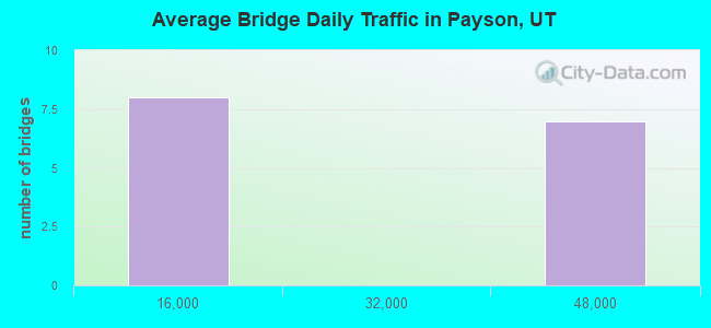
- 361,701Total average daily traffic
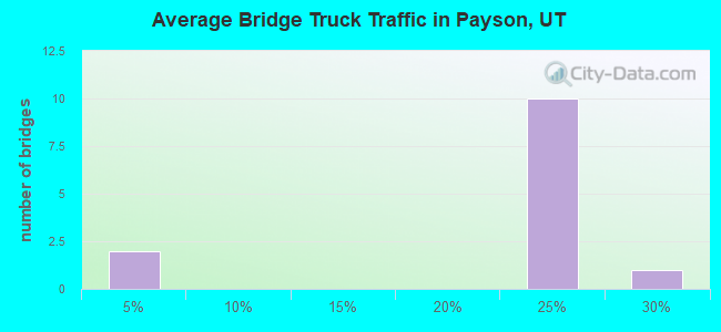
- 79,013Total average daily truck traffic
- National Bridge Inventory (NBI) Registered Bridges for Payson
- No street view available for this location
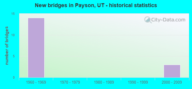
- New bridges - historical statistics
- 141960-1969
- 32000-2009
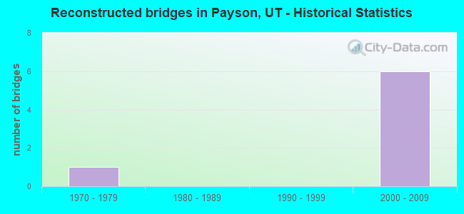
- Reconstructed bridges - Historical Statistics
- 11970-1979
- 01980-1989
- 01990-1999
- 62000-2009
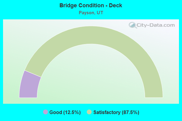
- Bridge Condition - Deck
- 12.5%Good
- 87.5%Satisfactory
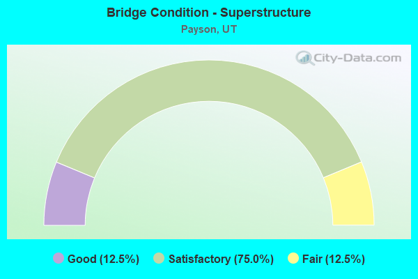
- Bridge Condition - Superstructure
- 12.5%Good
- 75.0%Satisfactory
- 12.5%Fair
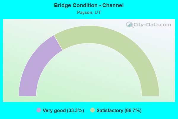
- Bridge Condition - Channel
- 33.3%Very good
- 66.7%Satisfactory
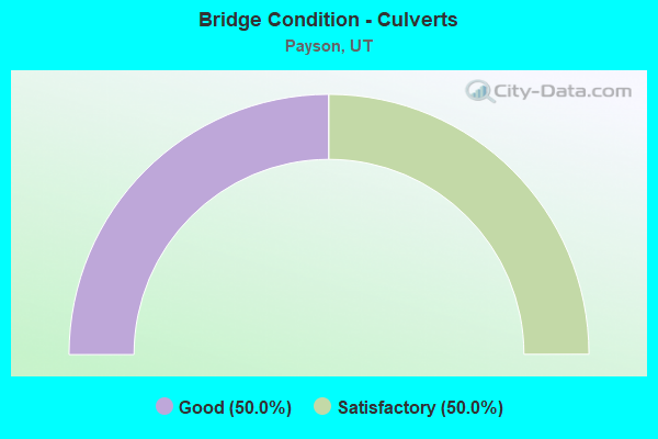
- Bridge Condition - Culverts
- 50.0%Good
- 50.0%Satisfactory
Find on map >> Show street view
Structure Number: 49004F, Location: 1260 S. 180 E., PAYSON (Lat: 40.023561, Lng: -111.729081), Route carried "on" structure: City street , Year Built: 2001, Status: Open, Structure Length: 1.07m (3.51ft), Average Daily Traffic: 630 (year 2020), Truck Traffic: 1%, Average Future Daily Traffic: 766 (year 2040), Design Load: HS 20+Mod, Features Intersected: HIGHLINE CANAL, Facility Carried by Structure: 180 EAST STREET
Minimum Vertical Clearance: 30+ m (98+ ft), Kilometerpoint: 0.062, Lanes on structure: 2, Owner: City or Municipal Highway Agency, Approaching Roadway Width: 13.1m (43.0ft), Material/Design: Prestressed concrete, Design/Construction: Tee Beam, Number Of Spans In Main Unit: 1, Length of Maximum Span: 9.8m (32.2ft), Curb or Sidewalk Widths: Left: 1.7m (5.6ft), Right: 1.7m (5.6ft), Curb-To-Curb Width: 13.1m (43.0ft), Out-to-Out Width: 16.5m (54.1ft)
Condition: Deck: Good, Superstructure: Good, Substructure: Satisfactory, Channel: Satisfactory, Operating Rating: 32.4 metric tons, Method Used To Determine Operating Rating: Load and Resistance Factor Rating (LRFR) rating reported by rating factor(RF) method using HL-93 loadings, Inventory Rating: 20.7 metric tons, Method Used To Determine Inventory Rating: Load Factor (LF) rating reported by rating factor (RF) method using MS18 loading, Structural Evaluation: Somewhat better than minimum adequacy, Deck Geometry: Superior to present desirable criteria, Waterway Adequacy: Equal to present desirable criteria, Approach Roadway Alignment: Equal to present desirable criteria, Designated Inspection Frequency: Every 24 months, Inspection Date: October 2021, Deck Structure Type: Concrete Precast Panels, Wearing Surface/Protective System: Wearing Surface: Monolithic Concrete, Deck Protection: Epoxy Coated Reinforcing
Find on map >> Show street view
Structure Number: 49032E, Location: 1150 S. PAYSON CYN. RD. (Lat: 40.026092, Lng: -111.726633), Route carried "on" structure: City street , Year Built: 2006, Status: Open, Structure Length: 0.68m (2.23ft), Average Daily Traffic: 1,537 (year 2020), Truck Traffic: 4%, Average Future Daily Traffic: 1,868 (year 2040), Design Load: HL 93, Features Intersected: HIGHLINE CANAL, Facility Carried by Structure: PAYSON CYN. ROAD
Minimum Vertical Clearance: 30+ m (98+ ft), Kilometerpoint: 0.004, Lanes on structure: 2, Owner: City or Municipal Highway Agency, Approaching Roadway Width: 10.4m (34.1ft), Skew: 3 degrees, Material/Design: Concrete, Design/Construction: Culvert, Number Of Spans In Main Unit: 1, Length of Maximum Span: 6.1m (20.0ft), Curb or Sidewalk Widths: Left: 1.5m (4.9ft), Right: 1.5m (4.9ft), Out-to-Out Width: 19.2m (63.0ft)
Condition: Channel: Very good, Culverts: Good, Operating Rating: 44.1 metric tons, Method Used To Determine Operating Rating: Load and Resistance Factor Rating (LRFR) rating reported by rating factor(RF) method using HL-93 loadings, Inventory Rating: 34.0 metric tons, Method Used To Determine Inventory Rating: Load and Resistance Factor Rating (LRFR) rating reported by rating factor(RF) method using HL-93 loadings, Structural Evaluation: Better than present minimum criteria, Waterway Adequacy: Better than present minimum criteria, Approach Roadway Alignment: Equal to present desirable criteria, Designated Inspection Frequency: Every 24 months, Inspection Date: October 2021
Find on map >> Show street view
Structure Number: 49051E, Location: 1160 S. 6TH E., PAYSON (Lat: 40.027378, Lng: -111.722883), Route carried "on" structure: City street 2825, Year Built: 2006, Status: Open, Structure Length: 0.69m (2.26ft), Average Daily Traffic: 799 (year 2020), Average Future Daily Traffic: 999 (year 2040), Design Load: HL 93, Features Intersected: HIGHLINE CANAL, Facility Carried by Structure: 600 EAST STREET
Minimum Vertical Clearance: 30+ m (98+ ft), Kilometerpoint: 0.288, Lanes on structure: 2, Owner: City or Municipal Highway Agency, Approaching Roadway Width: 12.1m (39.7ft), Material/Design: Concrete, Design/Construction: Culvert, Number Of Spans In Main Unit: 1, Length of Maximum Span: 6.4m (21.0ft), Curb or Sidewalk Widths: Left: 1.7m (5.6ft), Right: 1.7m (5.6ft), Curb-To-Curb Width: 12.1m (39.7ft), Out-to-Out Width: 15.8m (51.8ft)
Condition: Channel: Satisfactory, Culverts: Satisfactory, Operating Rating: 34.0 metric tons, Method Used To Determine Operating Rating: Load and Resistance Factor Rating (LRFR) rating reported by rating factor(RF) method using HL-93 loadings, Inventory Rating: 27.9 metric tons, Method Used To Determine Inventory Rating: Load and Resistance Factor Rating (LRFR) rating reported by rating factor(RF) method using HL-93 loadings, Structural Evaluation: Equal to present minimum criteria, Deck Geometry: Better than present minimum criteria, Waterway Adequacy: Better than present minimum criteria, Approach Roadway Alignment: Equal to present desirable criteria, Designated Inspection Frequency: Every 24 months, Inspection Date: October 2021, Deck Structure Type: Concrete Cast-file-Place, Wearing Surface/Protective System: Wearing Surface: Bituminous, Deck Protection: Epoxy Coated Reinforcing
Find on map >> Show street view
Structure Number: C 504, Location: SOUTH PAYSON INTERCHANGE (Lat: 40.031422, Lng: -111.757656), Route carried "on" structure: Ramp State highway 178, Year Built: 1967, Year Reconstructed: 1978, Status: Open, Structure Length: 7.37m (24.18ft), Average Daily Traffic: 12,353 (year 2020), Truck Traffic: 25%, Average Future Daily Traffic: 15,441 (year 2040), Design Load: HS 20+Mod, Features Intersected: I-15 (SR-15) NBL & S
Minimum Vertical Clearance: 30+ m (98+ ft), Kilometerpoint: 0.087, Lanes on structure: 2, Lanes under structure: 4, Owner: State Highway Agency, Approaching Roadway Width: 16.5m (54.1ft), Skew: 3 degrees, Material/Design: Steel continuous, Design/Construction: Stringer/Multi-beam, Number Of Spans In Main Unit: 2, Length of Maximum Span: 36.0m (118.1ft), Curb-To-Curb Width: 16.5m (54.1ft), Out-to-Out Width: 17.1m (56.1ft)
Condition: Deck: Satisfactory, Superstructure: Satisfactory, Substructure: Satisfactory, Operating Rating: 33.4 metric tons, Method Used To Determine Operating Rating: Load and Resistance Factor Rating (LRFR) rating reported by rating factor(RF) method using HL-93 loadings, Inventory Rating: 24.9 metric tons, Method Used To Determine Inventory Rating: Load and Resistance Factor Rating (LRFR) rating reported by rating factor(RF) method using HL-93 loadings, Structural Evaluation: Equal to present minimum criteria, Deck Geometry: Superior to present desirable criteria, Underclear: High priority of corrective action, Approach Roadway Alignment: Equal to present desirable criteria, Designated Inspection Frequency: Every 24 months, Inspection Date: March 2021, Deck Structure Type: Concrete Cast-file-Place, Wearing Surface/Protective System: Wearing Surface: Bituminous, Membrane: Preformed Fabric
Find on map >> Show street view
Structure Number: 1F 127, Location: PAYSON INTERCHANGE (Lat: 40.055122, Lng: -111.732506), Route carried "on" structure: Interstate 15, Year Built: 1967, Year Reconstructed: 2013, Status: Open, Structure Length: 4.85m (15.91ft), Average Daily Traffic: 46,994 (year 2020), Truck Traffic: 22%, Average Future Daily Traffic: 58,743 (year 2040), Design Load: HS 20, Features Intersected: SR-115,PAYSON MAIN ST
Minimum Vertical Clearance: 30+ m (98+ ft), Kilometerpoint: 404.363, Lanes on structure: 3, Lanes under structure: 3, Base Highway Network: Yes, Owner: State Highway Agency, Approaching Roadway Width: 17.9m (58.7ft), Skew: 15 degrees, Material/Design: Prestressed concrete, Design/Construction: Stringer/Multi-beam, Number Of Spans In Main Unit: 3, Length of Maximum Span: 21.2m (69.6ft), Curb-To-Curb Width: 17.9m (58.7ft), Out-to-Out Width: 18.5m (60.7ft)
Condition: Deck: Satisfactory, Superstructure: Satisfactory, Substructure: Satisfactory, Operating Rating: 35.0 metric tons, Method Used To Determine Operating Rating: Load and Resistance Factor Rating (LRFR) rating reported by rating factor(RF) method using HL-93 loadings, Inventory Rating: 22.0 metric tons, Method Used To Determine Inventory Rating: Load and Resistance Factor Rating (LRFR) rating reported by rating factor(RF) method using HL-93 loadings, Structural Evaluation: Somewhat better than minimum adequacy, Deck Geometry: Better than present minimum criteria, Underclear: High priority of corrective action, Approach Roadway Alignment: Equal to present desirable criteria, Designated Inspection Frequency: Every 24 months, Inspection Date: March 2021, Deck Structure Type: Concrete Precast Panels, Wearing Surface/Protective System: Wearing Surface: Epoxy Overlay, Deck Protection: Epoxy Coated Reinforcing
Find on map >> Show street view
Structure Number: 1F 129, Location: WEST SIDE OF PAYSON (Lat: 40.043458, Lng: -111.744883), Route carried "on" structure: Interstate 15, Year Built: 1967, Year Reconstructed: 2014, Status: Open, Structure Length: 4.32m (14.17ft), Average Daily Traffic: 46,994 (year 2020), Truck Traffic: 22%, Average Future Daily Traffic: 58,743 (year 2040), Design Load: HS 20, Features Intersected: SR-147
Minimum Vertical Clearance: 30+ m (98+ ft), Kilometerpoint: 402.691, Lanes on structure: 3, Lanes under structure: 3, Base Highway Network: Yes, Owner: State Highway Agency, Approaching Roadway Width: 17.7m (58.1ft), Skew: 13 degrees, Material/Design: Prestressed concrete, Design/Construction: Stringer/Multi-beam, Number Of Spans In Main Unit: 3, Length of Maximum Span: 18.7m (61.4ft), Curb-To-Curb Width: 17.7m (58.1ft), Out-to-Out Width: 18.5m (60.7ft)
Condition: Deck: Satisfactory, Superstructure: Satisfactory, Substructure: Satisfactory, Operating Rating: 34.0 metric tons, Method Used To Determine Operating Rating: Load and Resistance Factor Rating (LRFR) rating reported by rating factor(RF) method using HL-93 loadings, Inventory Rating: 22.0 metric tons, Method Used To Determine Inventory Rating: Load and Resistance Factor Rating (LRFR) rating reported by rating factor(RF) method using HL-93 loadings, Structural Evaluation: Somewhat better than minimum adequacy, Deck Geometry: Better than present minimum criteria, Underclear: Equal to present minimum criteria, Approach Roadway Alignment: Equal to present desirable criteria, Designated Inspection Frequency: Every 24 months, Inspection Date: March 2021, Deck Structure Type: Concrete Precast Panels, Wearing Surface/Protective System: Wearing Surface: Epoxy Overlay, Deck Protection: Epoxy Coated Reinforcing
Find on map >> Show street view
Structure Number: 1F 13, Location: IN PAYSON (Lat: 40.048411, Lng: -111.739897), Route carried "on" structure: Interstate 15, Year Built: 1967, Year Reconstructed: 2013, Status: Open, Structure Length: 4.25m (13.94ft), Average Daily Traffic: 46,994 (year 2020), Truck Traffic: 22%, Average Future Daily Traffic: 58,743 (year 2040), Design Load: HS 20+Mod, Features Intersected: 400 NORTH STREET
Minimum Vertical Clearance: 30+ m (98+ ft), Kilometerpoint: 403.386, Lanes on structure: 3, Lanes under structure: 2, Base Highway Network: Yes, Owner: State Highway Agency, Approaching Roadway Width: 17.7m (58.1ft), Skew: 12 degrees, Material/Design: Prestressed concrete, Design/Construction: Stringer/Multi-beam, Number Of Spans In Main Unit: 3, Length of Maximum Span: 16.2m (53.1ft), Curb-To-Curb Width: 17.7m (58.1ft), Out-to-Out Width: 18.7m (61.4ft)
Condition: Deck: Satisfactory, Superstructure: Satisfactory, Substructure: Satisfactory, Operating Rating: 35.3 metric tons, Method Used To Determine Operating Rating: Load and Resistance Factor Rating (LRFR) rating reported by rating factor(RF) method using HL-93 loadings, Inventory Rating: 20.1 metric tons, Method Used To Determine Inventory Rating: Load Factor (LF) rating reported by rating factor (RF) method using MS18 loading, Structural Evaluation: Somewhat better than minimum adequacy, Deck Geometry: Better than present minimum criteria, Underclear: Meets minimum limits, Approach Roadway Alignment: Equal to present desirable criteria, Designated Inspection Frequency: Every 24 months, Inspection Date: March 2021, Deck Structure Type: Concrete Precast Panels, Wearing Surface/Protective System: Wearing Surface: Epoxy Overlay, Deck Protection: Epoxy Coated Reinforcing
Find on map >> Show street view
Structure Number: 3F 127, Location: PAYSON INTERCHANGE (Lat: 40.055883, Lng: -111.732056), Route carried "on" structure: Interstate 15, Year Built: 1967, Year Reconstructed: 2013, Status: Open, Structure Length: 4.77m (15.65ft), Average Daily Traffic: 46,994 (year 2020), Truck Traffic: 22%, Average Future Daily Traffic: 58,743 (year 2040), Design Load: HS 20, Features Intersected: SR-115, PAYSON MAIN ST.
Minimum Vertical Clearance: 30+ m (98+ ft), Kilometerpoint: 404.270, Lanes on structure: 3, Lanes under structure: 3, Base Highway Network: Yes, Owner: State Highway Agency, Approaching Roadway Width: 17.9m (58.7ft), Skew: 15 degrees, Material/Design: Prestressed concrete, Design/Construction: Stringer/Multi-beam, Number Of Spans In Main Unit: 3, Length of Maximum Span: 21.6m (70.9ft), Curb-To-Curb Width: 17.9m (58.7ft), Out-to-Out Width: 18.4m (60.4ft)
Condition: Deck: Satisfactory, Superstructure: Fair, Substructure: Satisfactory, Operating Rating: 35.0 metric tons, Method Used To Determine Operating Rating: Load and Resistance Factor Rating (LRFR) rating reported by rating factor(RF) method using HL-93 loadings, Inventory Rating: 22.0 metric tons, Method Used To Determine Inventory Rating: Load and Resistance Factor Rating (LRFR) rating reported by rating factor(RF) method using HL-93 loadings, Structural Evaluation: Somewhat better than minimum adequacy, Deck Geometry: Better than present minimum criteria, Underclear: High priority of corrective action, Approach Roadway Alignment: Equal to present desirable criteria, Designated Inspection Frequency: Every 24 months, Inspection Date: March 2021, Deck Structure Type: Concrete Precast Panels, Wearing Surface/Protective System: Wearing Surface: Epoxy Overlay, Deck Protection: Epoxy Coated Reinforcing
Find on map >> Show street view
Structure Number: 3F 129, Location: WEST SIDE OF PAYSON (Lat: 40.043864, Lng: -111.744789), Route carried "on" structure: Interstate 15, Year Built: 1967, Year Reconstructed: 2013, Status: Open, Structure Length: 4.32m (14.17ft), Average Daily Traffic: 46,994 (year 2020), Truck Traffic: 22%, Average Future Daily Traffic: 58,743 (year 2040), Design Load: HS 20, Features Intersected: SR-147
Minimum Vertical Clearance: 30+ m (98+ ft), Kilometerpoint: 402.548, Lanes on structure: 3, Lanes under structure: 2, Base Highway Network: Yes, Owner: State Highway Agency, Approaching Roadway Width: 17.7m (58.1ft), Skew: 13 degrees, Material/Design: Prestressed concrete, Design/Construction: Stringer/Multi-beam, Number Of Spans In Main Unit: 3, Length of Maximum Span: 19.0m (62.3ft), Curb-To-Curb Width: 17.7m (58.1ft), Out-to-Out Width: 18.5m (60.7ft)
Condition: Deck: Satisfactory, Superstructure: Satisfactory, Substructure: Satisfactory, Operating Rating: 34.0 metric tons, Method Used To Determine Operating Rating: Load and Resistance Factor Rating (LRFR) rating reported by rating factor(RF) method using HL-93 loadings, Inventory Rating: 22.0 metric tons, Method Used To Determine Inventory Rating: Load and Resistance Factor Rating (LRFR) rating reported by rating factor(RF) method using HL-93 loadings, Structural Evaluation: Somewhat better than minimum adequacy, Deck Geometry: Better than present minimum criteria, Underclear: Equal to present minimum criteria, Approach Roadway Alignment: Equal to present desirable criteria, Designated Inspection Frequency: Every 24 months, Inspection Date: March 2021, Deck Structure Type: Concrete Precast Panels, Wearing Surface/Protective System: Wearing Surface: Epoxy Overlay, Deck Protection: Epoxy Coated Reinforcing
Find on map >> Show street view
Structure Number: 3F 13, Location: IN PAYSON (Lat: 40.048817, Lng: -111.739844), Route carried "on" structure: Interstate 15, Year Built: 1967, Year Reconstructed: 2013, Status: Open, Structure Length: 4.25m (13.94ft), Average Daily Traffic: 46,994 (year 2020), Truck Traffic: 22%, Average Future Daily Traffic: 58,743 (year 2040), Design Load: HS 20, Features Intersected: 400 NORTH STREET
Minimum Vertical Clearance: 30+ m (98+ ft), Kilometerpoint: 403.241, Lanes on structure: 3, Lanes under structure: 2, Base Highway Network: Yes, Owner: State Highway Agency, Approaching Roadway Width: 17.7m (58.1ft), Skew: 12 degrees, Material/Design: Prestressed concrete, Design/Construction: Stringer/Multi-beam, Number Of Spans In Main Unit: 3, Length of Maximum Span: 16.2m (53.1ft), Curb-To-Curb Width: 17.7m (58.1ft), Out-to-Out Width: 18.4m (60.4ft)
Condition: Deck: Satisfactory, Superstructure: Satisfactory, Substructure: Satisfactory, Operating Rating: 38.9 metric tons, Method Used To Determine Operating Rating: Load and Resistance Factor Rating (LRFR) rating reported by rating factor(RF) method using HL-93 loadings, Inventory Rating: 33.4 metric tons, Method Used To Determine Inventory Rating: Load Factor (LF) rating reported by rating factor (RF) method using MS18 loading, Structural Evaluation: Equal to present minimum criteria, Deck Geometry: Better than present minimum criteria, Underclear: Meets minimum limits, Approach Roadway Alignment: Equal to present desirable criteria, Designated Inspection Frequency: Every 24 months, Inspection Date: March 2021, Deck Structure Type: Concrete Precast Panels, Wearing Surface/Protective System: Wearing Surface: Epoxy Overlay, Deck Protection: Epoxy Coated Reinforcing
Find on map >> Show street view
Structure Number: C 504, Location: SOUTH PAYSON INTERCHANGE (Lat: 40.031422, Lng: -111.757656), Route carried "under" structure: Interstate 15, Year Built: 1967, Structure Length: 0. m, Average Daily Traffic: 42,776 (year 2020), Truck Traffic: 22%, Features Intersected: I-15 (SR-15) NBL & S, Facility Carried by Structure: SR-178 800 S. INT.
Minimum Vertical Clearance: 4.91m (16.11ft), Kilometerpoint: 400.437, Lanes on structure: 2, Lanes under structure: 4, Material/Design: Steel continuous, Design/Construction: Stringer/Multi-beam, Length of Maximum Span: 36.0m (118.1ft)
Find on map >> Show street view
Structure Number: 1F 127, Location: PAYSON INTERCHANGE (Lat: 40.055122, Lng: -111.732506), Route carried "under" structure: State highway 115, Year Built: 1967, Structure Length: 0. m, Average Daily Traffic: 14,967 (year 2020), Truck Traffic: 24%, Features Intersected: SR-115,PAYSON MAIN ST, Facility Carried by Structure: I-15 (SR-15) NBL
Minimum Vertical Clearance: 4.64m (15.22ft), Kilometerpoint: 1.191, Lanes on structure: 3, Lanes under structure: 3, Material/Design: Prestressed concrete, Design/Construction: Stringer/Multi-beam, Length of Maximum Span: 21.2m (69.6ft)
Find on map >> Show street view
Structure Number: 1F 129, Location: WEST SIDE OF PAYSON (Lat: 40.043458, Lng: -111.744883), Route carried "under" structure: City street 2869, Year Built: 1967, Structure Length: 0. m, Average Daily Traffic: 3,197 (year 2020), Features Intersected: SR-147, Facility Carried by Structure: I-15 (SR-15) NBL
Minimum Vertical Clearance: 4.67m (15.32ft), Kilometerpoint: 0.901, Lanes on structure: 3, Lanes under structure: 3, Material/Design: Prestressed concrete, Design/Construction: Stringer/Multi-beam, Length of Maximum Span: 18.7m (61.4ft)
Find on map >> Show street view
Structure Number: 1F 13, Location: IN PAYSON (Lat: 40.048411, Lng: -111.739897), Route carried "under" structure: City street , Year Built: 1967, Structure Length: 0. m, Features Intersected: 400 NORTH STREET, Facility Carried by Structure: I-15 (SR-15) NBL
Minimum Vertical Clearance: 4.58m (15.03ft), Kilometerpoint: 0.000, Lanes on structure: 3, Lanes under structure: 2, Material/Design: Prestressed concrete, Design/Construction: Stringer/Multi-beam, Length of Maximum Span: 16.2m (53.1ft)
Find on map >> Show street view
Structure Number: 3F 127, Location: PAYSON INTERCHANGE (Lat: 40.055883, Lng: -111.732056), Route carried "under" structure: State highway 115, Year Built: 1967, Structure Length: 0. m, Average Daily Traffic: 2,941 (year 2020), Truck Traffic: 24%, Features Intersected: SR-115, PAYSON MAIN ST., Facility Carried by Structure: I-15 (SR-15) SBL
Minimum Vertical Clearance: 4.61m (15.12ft), Kilometerpoint: 1.239, Lanes on structure: 3, Lanes under structure: 3, Material/Design: Prestressed concrete, Design/Construction: Stringer/Multi-beam, Length of Maximum Span: 21.6m (70.9ft)
Find on map >> Show street view
Structure Number: 3F 129, Location: WEST SIDE OF PAYSON (Lat: 40.043864, Lng: -111.744789), Route carried "under" structure: State highway 147, Year Built: 1967, Structure Length: 0. m, Average Daily Traffic: 537 (year 2020), Truck Traffic: 23%, Features Intersected: SR-147, Facility Carried by Structure: I-15 (SR-15) SBL
Minimum Vertical Clearance: 5.00m (16.40ft), Kilometerpoint: 0.950, Lanes on structure: 3, Lanes under structure: 2, Material/Design: Prestressed concrete, Design/Construction: Stringer/Multi-beam, Length of Maximum Span: 19.0m (62.3ft)
Find on map >> Show street view
Structure Number: 3F 13, Location: IN PAYSON (Lat: 40.048817, Lng: -111.739844), Route carried "under" structure: City street , Year Built: 1967, Structure Length: 0. m, Features Intersected: 400 NORTH STREET, Facility Carried by Structure: I-15 (SR-15) SBL
Minimum Vertical Clearance: 4.77m (15.65ft), Kilometerpoint: 0.000, Lanes on structure: 3, Lanes under structure: 2, Material/Design: Prestressed concrete, Design/Construction: Stringer/Multi-beam, Length of Maximum Span: 16.2m (53.1ft)