Bridge Statistics for Paxtang, Pennsylvania (PA)
Condition, Traffic, Stress, Structural Evaluation, Project Costs
- National Bridge Inventory (NBI) Statistics
- 15Number of bridges
- 79ft / 23.8mTotal length
- $2,623,000Total costs
- 529,302Total average daily traffic
- 55,168Total average daily truck traffic
- National Bridge Inventory (NBI) Registered Bridges for Paxtang
- No street view available for this location
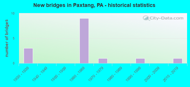
- New bridges - historical statistics
- 31930-1939
- 91960-1969
- 11970-1979
- 11990-1999
- 12010-2019

- Reconstructed bridges - Historical Statistics
- 11980-1989
- 11990-1999


- Bridge Condition - Deck
- 50.0%Good
- 25.0%Satisfactory
- 12.5%Fair
- 12.5%Poor

- Bridge Condition - Superstructure
- 12.5%Very good
- 12.5%Good
- 37.5%Satisfactory
- 25.0%Fair
- 12.5%Poor

- Bridge Condition - Substructure
- 25.0%Good
- 50.0%Satisfactory
- 25.0%Fair

- Bridge Condition - Channel
- 14.3%Very good
- 14.3%Good
- 57.1%Satisfactory
- 14.3%Fair

- Bridge Condition - Culverts
- 50.0%Satisfactory
- 50.0%Fair
Find on map >> Show street view
Structure Number: 14268, Location: SWATARA TOWNSHIP (Lat: 40.257114, Lng: -76.833072), Route carried "on" structure: Interstate 83, Year Built: 1961, Year Reconstructed: 1991, Status: Open, Structure Length: 6.52m (21.39ft), Average Daily Traffic: 109,965 (year 2022), Truck Traffic: 12%, Average Future Daily Traffic: 130,597 (year 2032), Design Load: HS 20, Features Intersected: SPRING CR, City Park Dr
Minimum Vertical Clearance: 30+ m (98+ ft), Kilometerpoint: 3.936, Lanes on structure: 4, Lanes under structure: 2, Base Highway Network: Yes, Owner: State Highway Agency, Approaching Roadway Width: 20.7m (67.9ft), Skew: 31 degrees, Material/Design: Steel continuous, Design/Construction: Stringer/Multi-beam, Number Of Spans In Main Unit: 3, Length of Maximum Span: 26.2m (86.0ft), Curb or Sidewalk Widths: Left: 0.2m (0.7ft), Right: 0.2m (0.7ft), Curb-To-Curb Width: 21.3m (69.9ft), Out-to-Out Width: 23.0m (75.5ft)
Condition: Deck: Good, Superstructure: Satisfactory, Substructure: Satisfactory, Channel: Very good, Operating Rating: 83.5 metric tons, Method Used To Determine Operating Rating: Load Factor (LF), Inventory Rating: 49.9 metric tons, Method Used To Determine Inventory Rating: Load Factor (LF), Structural Evaluation: Equal to present minimum criteria, Deck Geometry: Better than present minimum criteria, Underclear: Somewhat better than minimum adequacy, Waterway Adequacy: Superior to present desirable criteria, Approach Roadway Alignment: Equal to present desirable criteria, Length Of Structure Improvement: 7.50m (24.61ft), Designated Inspection Frequency: Every 24 months, Inspection Date: November 2020, Bridge Improvement Cost: $82,000, Roadway Improvement Cost: $240,000, Total Project Cost: $1,101,000, Deck Structure Type: Concrete Cast-file-Place, Wearing Surface/Protective System: Wearing Surface: Monolithic Concrete, Deck Protection: Epoxy Coated Reinforcing
Find on map >> Show street view
Structure Number: 14269, Location: .5 MI.W.OF EISENH.INTERCH (Lat: 40.254933, Lng: -76.828428), Route carried "on" structure: Interstate 83, Year Built: 1961, Status: Open, Structure Length: 0.91m (2.99ft), Average Daily Traffic: 109,965 (year 2022), Truck Traffic: 12%, Average Future Daily Traffic: 130,597 (year 2032), Design Load: HS 20, Features Intersected: SPRING CREEK
Minimum Vertical Clearance: 30+ m (98+ ft), Kilometerpoint: 4.741, Lanes on structure: 2, Base Highway Network: Yes, Owner: State Highway Agency, Approaching Roadway Width: 21.9m (71.9ft), Skew: 31 degrees, Material/Design: Concrete, Design/Construction: Culvert, Number Of Spans In Main Unit: 1, Length of Maximum Span: 9.1m (29.9ft)
Condition: Channel: Good, Culverts: Satisfactory, Operating Rating: 79.8 metric tons, Method Used To Determine Operating Rating: Field evaluation and documented engineering judgment, Inventory Rating: 48.1 metric tons, Method Used To Determine Inventory Rating: Field evaluation and documented engineering judgment, Structural Evaluation: Equal to present minimum criteria, Waterway Adequacy: Superior to present desirable criteria, Approach Roadway Alignment: Equal to present desirable criteria, Length Of Structure Improvement: 1.60m (5.25ft), Designated Inspection Frequency: Every 24 months, Inspection Date: December 2020
Find on map >> Show street view
Structure Number: 14526, Location: SWATARA TWP (Lat: 40.254808, Lng: -76.833594), Route carried "on" structure: Spur State highway , Year Built: 1936, Status: Open, Structure Length: 0.79m (2.59ft), Average Daily Traffic: 18,463 (year 2021), Truck Traffic: 3%, Average Future Daily Traffic: 21,576 (year 2032), Design Load: H 20, Features Intersected: SPRING CREEK, Facility Carried by Structure: SR 3010
Minimum Vertical Clearance: 30+ m (98+ ft), Kilometerpoint: 2.604, Lanes on structure: 3, Base Highway Network: Yes, Owner: State Highway Agency, Approaching Roadway Width: 14.3m (46.9ft), Material/Design: Concrete, Design/Construction: Culvert, Number Of Spans In Main Unit: 1, Length of Maximum Span: 7.9m (25.9ft)
Condition: Channel: Satisfactory, Culverts: Fair, Operating Rating: 63.5 metric tons, Method Used To Determine Operating Rating: Allowable Stress (AS), Inventory Rating: 42.6 metric tons, Method Used To Determine Inventory Rating: Allowable Stress (AS), Structural Evaluation: Somewhat better than minimum adequacy, Waterway Adequacy: Equal to present desirable criteria, Approach Roadway Alignment: Equal to present desirable criteria, Length Of Structure Improvement: 1.40m (4.59ft), Designated Inspection Frequency: Every 24 months, Inspection Date: December 2020
Find on map >> Show street view
Structure Number: 14528, Location: SWATARA TOWNSHIP (Lat: 40.254139, Lng: -76.826144), Route carried "on" structure: Ramp State highway , Year Built: 1961, Status: Open, Structure Length: 3.75m (12.30ft), Average Daily Traffic: 9,631 (year 2022), Truck Traffic: 7%, Average Future Daily Traffic: 12,896 (year 2035), Design Load: HS 20, Features Intersected: I-83; SR 0083, Facility Carried by Structure: SR 3010 WB
Minimum Vertical Clearance: 30+ m (98+ ft), Kilometerpoint: 0.000, Lanes on structure: 2, Lanes under structure: 2, Owner: State Highway Agency, Approaching Roadway Width: 14.0m (45.9ft), Skew: 5 degrees, Material/Design: Steel, Design/Construction: Stringer/Multi-beam, Number Of Spans In Main Unit: 1, Length of Maximum Span: 36.6m (120.1ft), Curb or Sidewalk Widths: Left: 0.3m (1.0ft), Right: 0.3m (1.0ft), Curb-To-Curb Width: 12.2m (40.0ft), Out-to-Out Width: 13.6m (44.6ft)
Condition: Deck: Satisfactory, Superstructure: Fair, Substructure: Fair, Operating Rating: 78.0 metric tons, Method Used To Determine Operating Rating: Load Factor (LF), Inventory Rating: 46.3 metric tons, Method Used To Determine Inventory Rating: Load Factor (LF), Structural Evaluation: Somewhat better than minimum adequacy, Deck Geometry: Superior to present desirable criteria, Underclear: High priority of corrective action, Approach Roadway Alignment: Equal to present desirable criteria, Length Of Structure Improvement: 4.70m (15.42ft), Designated Inspection Frequency: Every 24 months, Inspection Date: December 2020, Bridge Improvement Cost: $15,000, Roadway Improvement Cost: $44,000, Total Project Cost: $203,000, Deck Structure Type: Concrete Cast-file-Place, Wearing Surface/Protective System: Wearing Surface: Latex Concrete
Find on map >> Show street view
Structure Number: 14533, Location: DERRY STREET (Lat: 40.259214, Lng: -76.835033), Route carried "on" structure: State highway , Year Built: 1938, Year Reconstructed: 1996, Status: Open, Structure Length: 0.76m (2.49ft), Average Daily Traffic: 11,377 (year 2021), Truck Traffic: 3%, Average Future Daily Traffic: 15,531 (year 2032), Design Load: HS 25 or greater, Features Intersected: TRIB SPRING CREEK, Facility Carried by Structure: SR 3012
Minimum Vertical Clearance: 30+ m (98+ ft), Kilometerpoint: 4.674, Lanes on structure: 2, Owner: State Highway Agency, Approaching Roadway Width: 11.6m (38.1ft), Material/Design: Concrete continuous, Design/Construction: Slab, Number Of Spans In Main Unit: 2, Length of Maximum Span: 3.4m (11.2ft), Curb or Sidewalk Widths: Left: 1.6m (5.2ft), Right: 1.6m (5.2ft), Curb-To-Curb Width: 11.6m (38.1ft), Out-to-Out Width: 15.3m (50.2ft)
Condition: Deck: Good, Superstructure: Good, Substructure: Satisfactory, Channel: Satisfactory, Operating Rating: 62.6 metric tons, Method Used To Determine Operating Rating: Load Factor (LF), Inventory Rating: 37.2 metric tons, Method Used To Determine Inventory Rating: Load Factor (LF), Structural Evaluation: Equal to present minimum criteria, Deck Geometry: Somewhat better than minimum adequacy, Waterway Adequacy: Equal to present minimum criteria, Approach Roadway Alignment: Equal to present desirable criteria, Length Of Structure Improvement: 1.40m (4.59ft), Designated Inspection Frequency: Every 24 months, Inspection Date: December 2020, Wearing Surface/Protective System: Wearing Surface: Monolithic Concrete, Deck Protection: Epoxy Coated Reinforcing
Find on map >> Show street view
Structure Number: 14534, Location: DERRY STREET-PAXTANG (Lat: 40.258497, Lng: -76.825844), Route carried "on" structure: State highway , Year Built: 1938, Status: Open, Structure Length: 1.13m (3.71ft), Average Daily Traffic: 11,662 (year 2022), Truck Traffic: 3%, Average Future Daily Traffic: 17,815 (year 2032), Design Load: H 20, Features Intersected: SPRING CREEK, Facility Carried by Structure: SR 3012
Minimum Vertical Clearance: 30+ m (98+ ft), Kilometerpoint: 5.409, Lanes on structure: 2, Owner: State Highway Agency, Approaching Roadway Width: 11.6m (38.1ft), Skew: 3 degrees, Material/Design: Concrete, Design/Construction: Slab, Number Of Spans In Main Unit: 2, Length of Maximum Span: 5.2m (17.1ft), Curb or Sidewalk Widths: Left: 1.5m (4.9ft), Right: 1.5m (4.9ft), Curb-To-Curb Width: 11.6m (38.1ft), Out-to-Out Width: 15.2m (49.9ft)
Condition: Deck: Poor, Superstructure: Poor, Substructure: Satisfactory, Channel: Satisfactory, Operating Rating: 46.3 metric tons, Method Used To Determine Operating Rating: Load Factor (LF), Inventory Rating: 28.1 metric tons, Method Used To Determine Inventory Rating: Load Factor (LF), Structural Evaluation: Meets minimum limits, Deck Geometry: Somewhat better than minimum adequacy, Waterway Adequacy: Equal to present minimum criteria, Approach Roadway Alignment: Equal to present desirable criteria, Length Of Structure Improvement: 1.70m (5.58ft), Designated Inspection Frequency: Every 24 months, Inspection Date: December 2020, Bridge Improvement Cost: $72,000, Roadway Improvement Cost: $212,000, Total Project Cost: $971,000, Wearing Surface/Protective System: Wearing Surface: Bituminous
Find on map >> Show street view
Structure Number: 14536, Location: 29TH STREET OVER I-83 (Lat: 40.258197, Lng: -76.839567), Route carried "on" structure: State highway , Year Built: 1961, Status: Open, Structure Length: 2.38m (7.81ft), Average Daily Traffic: 10,822 (year 2021), Truck Traffic: 1%, Average Future Daily Traffic: 15,056 (year 2032), Design Load: HS 20, Features Intersected: I-83; SR 0083, Facility Carried by Structure: SR 3013
Minimum Vertical Clearance: 30+ m (98+ ft), Kilometerpoint: 0.122, Lanes on structure: 2, Lanes under structure: 8, Owner: State Highway Agency, Approaching Roadway Width: 12.2m (40.0ft), Material/Design: Concrete, Design/Construction: Frame, Number Of Spans In Main Unit: 1, Length of Maximum Span: 20.7m (67.9ft), Curb or Sidewalk Widths: Left: 1.5m (4.9ft), Right: 1.5m (4.9ft), Curb-To-Curb Width: 12.2m (40.0ft), Out-to-Out Width: 16.0m (52.5ft)
Condition: Deck: Satisfactory, Superstructure: Satisfactory, Substructure: Satisfactory, Operating Rating: 49.0 metric tons, Method Used To Determine Operating Rating: Field evaluation and documented engineering judgment, Inventory Rating: 32.7 metric tons, Method Used To Determine Inventory Rating: Field evaluation and documented engineering judgment, Structural Evaluation: Equal to present minimum criteria, Deck Geometry: Somewhat better than minimum adequacy, Underclear: High priority of corrective action, Approach Roadway Alignment: Equal to present desirable criteria, Length Of Structure Improvement: 3.10m (10.17ft), Designated Inspection Frequency: Every 24 months, Inspection Date: December 2020, Bridge Improvement Cost: $12,000, Roadway Improvement Cost: $34,000, Total Project Cost: $157,000, Deck Structure Type: Concrete Cast-file-Place, Wearing Surface/Protective System: Wearing Surface: Monolithic Concrete
Find on map >> Show street view
Structure Number: 14537, Location: 29THSTPAXTANGBORO (Lat: 40.258569, Lng: -76.839636), Route carried "on" structure: State highway , Year Built: 1973, Status: Open, Structure Length: 2.99m (9.81ft), Average Daily Traffic: 10,822 (year 2021), Truck Traffic: 1%, Average Future Daily Traffic: 15,056 (year 2032), Design Load: HS 20, Features Intersected: NORFOLK SOUTHERN, Facility Carried by Structure: SR 3013 29th St.
Minimum Vertical Clearance: 30+ m (98+ ft), Kilometerpoint: 0.122, Lanes on structure: 2, Owner: State Highway Agency, Approaching Roadway Width: 12.2m (40.0ft), Material/Design: Prestressed concrete, Design/Construction: Box Beam or Girders - Multiple, Number Of Spans In Main Unit: 2, Length of Maximum Span: 18.0m (59.1ft), Curb or Sidewalk Widths: Left: 1.5m (4.9ft), Right: 1.5m (4.9ft), Curb-To-Curb Width: 12.2m (40.0ft), Out-to-Out Width: 16.0m (52.5ft)
Condition: Deck: Fair, Superstructure: Fair, Substructure: Fair, Operating Rating: 72.6 metric tons, Method Used To Determine Operating Rating: Load Factor (LF), Inventory Rating: 32.7 metric tons, Method Used To Determine Inventory Rating: Load Factor (LF), Structural Evaluation: Somewhat better than minimum adequacy, Deck Geometry: Somewhat better than minimum adequacy, Underclear: High priority of corrective action, Approach Roadway Alignment: Equal to present desirable criteria, Length Of Structure Improvement: 3.70m (12.14ft), Designated Inspection Frequency: Every 24 months, Inspection Date: November 2020, Bridge Improvement Cost: $14,000, Roadway Improvement Cost: $42,000, Total Project Cost: $191,000, Wearing Surface/Protective System: Wearing Surface: Monolithic Concrete
Find on map >> Show street view
Structure Number: 40728, Location: 1.3 MI N OF STEELTON (Lat: 40.251419, Lng: -76.836817), Route carried "on" structure: State highway 441, Year Built: 1999, Status: Open, Structure Length: 3.11m (10.20ft), Average Daily Traffic: 10,007 (year 2022), Truck Traffic: 3%, Average Future Daily Traffic: 6,912 (year 2032), Design Load: HS 20, Features Intersected: SPRING CREEK
Minimum Vertical Clearance: 30+ m (98+ ft), Kilometerpoint: 20.268, Lanes on structure: 2, Owner: State Highway Agency, Approaching Roadway Width: 14.3m (46.9ft), Skew: 2 degrees, Material/Design: Prestressed concrete, Design/Construction: Box Beam or Girders - Single/Spread, Number Of Spans In Main Unit: 2, Length of Maximum Span: 15.2m (49.9ft), Curb or Sidewalk Widths: Left: 0.2m (0.7ft), Right: 0.2m (0.7ft), Curb-To-Curb Width: 15.2m (49.9ft), Out-to-Out Width: 16.1m (52.8ft)
Condition: Deck: Good, Superstructure: Satisfactory, Substructure: Good, Channel: Satisfactory, Operating Rating: 82.6 metric tons, Method Used To Determine Operating Rating: Load Factor (LF), Inventory Rating: 44.5 metric tons, Method Used To Determine Inventory Rating: Load Factor (LF), Structural Evaluation: Equal to present minimum criteria, Deck Geometry: Superior to present desirable criteria, Waterway Adequacy: Somewhat better than minimum adequacy, Approach Roadway Alignment: Equal to present desirable criteria, Length Of Structure Improvement: 3.90m (12.80ft), Designated Inspection Frequency: Every 24 months, Inspection Date: October 2020, Deck Structure Type: Concrete Cast-file-Place, Wearing Surface/Protective System: Wearing Surface: Monolithic Concrete, Deck Protection: Epoxy Coated Reinforcing
Find on map >> Show street view
Structure Number: 48289, Location: SPRG CRK OFF DERRY STREET (Lat: 40.260175, Lng: -76.820389), Route carried "on" structure: Alternate City street , Year Built: 2013, Status: Open, Structure Length: 1.43m (4.69ft), Average Daily Traffic: 1,920 (year 2019), Truck Traffic: 5%, Average Future Daily Traffic: 2,243 (year 2039), Design Load: HL 93, Features Intersected: Spring Creek, Facility Carried by Structure: Bonnymeade Ave.
Minimum Vertical Clearance: 30+ m (98+ ft), Kilometerpoint: 0.000, Lanes on structure: 2, Toll: Toll bridge, Owner: Town or Township Highway Agency, Approaching Roadway Width: 10.4m (34.1ft), Skew: 3 degrees, Material/Design: Prestressed concrete, Design/Construction: Box Beam or Girders - Single/Spread, Number Of Spans In Main Unit: 1, Length of Maximum Span: 13.7m (44.9ft), Curb or Sidewalk Widths: Left: 1.7m (5.6ft), Right: 1.7m (5.6ft), Curb-To-Curb Width: 10.4m (34.1ft), Out-to-Out Width: 14.4m (47.2ft)
Condition: Deck: Good, Superstructure: Very good, Substructure: Good, Channel: Fair, Operating Rating: 60.9 metric tons, Method Used To Determine Operating Rating: Assigned ratings based on Load and Resistance Factor Design (LRFD) reported by rating factor (RF) using HL93 loadings, Inventory Rating: 44.7 metric tons, Method Used To Determine Inventory Rating: Assigned ratings based on Load and Resistance Factor Design (LRFD) reported by rating factor (RF) using HL93 loadings, Structural Evaluation: Better than present minimum criteria, Deck Geometry: Equal to present minimum criteria, Waterway Adequacy: Better than present minimum criteria, Approach Roadway Alignment: Equal to present desirable criteria, Designated Inspection Frequency: Every 24 months, Inspection Date: May 2021, Deck Structure Type: Concrete Cast-file-Place, Wearing Surface/Protective System: Wearing Surface: Monolithic Concrete, Deck Protection: Epoxy Coated Reinforcing
Find on map >> Show street view
Structure Number: 14268, Location: SWATARA TOWNSHIP (Lat: 40.257114, Lng: -76.833072), Route carried "under" structure: City street 3029, Year Built: 1961, Structure Length: 0. m, Average Daily Traffic: 4,738 (year 2001), Truck Traffic: 1%, Features Intersected: SPRING CR, City Park Dr, Facility Carried by Structure: I-83; SR 0083
Minimum Vertical Clearance: 4.39m (14.40ft), Kilometerpoint: 0.000, Lanes on structure: 4, Lanes under structure: 2, Material/Design: Steel continuous, Design/Construction: Stringer/Multi-beam, Length of Maximum Span: 26.2m (86.0ft)
Find on map >> Show street view
Structure Number: 14528, Location: SWATARA TOWNSHIP (Lat: 40.254139, Lng: -76.826144), Route carried "under" structure: Interstate 83, Year Built: 1961, Structure Length: 0. m, Average Daily Traffic: 50,306 (year 2022), Truck Traffic: 13%, Features Intersected: I-83; SR 0083, Facility Carried by Structure: SR 3010 WB
Minimum Vertical Clearance: 4.34m (14.24ft), Kilometerpoint: 4.741, Lanes on structure: 2, Lanes under structure: 2, Material/Design: Steel, Design/Construction: Stringer/Multi-beam, Length of Maximum Span: 36.6m (120.1ft)
Find on map >> Show street view
Structure Number: 14528, Location: SWATARA TOWNSHIP (Lat: 40.254139, Lng: -76.826144), Route carried "under" structure: Interstate 83, Year Built: 1961, Structure Length: 0. m, Average Daily Traffic: 59,659 (year 2022), Truck Traffic: 11%, Features Intersected: I-83; SR 0083, Facility Carried by Structure: SR 3010 WB
Minimum Vertical Clearance: 4.54m (14.90ft), Kilometerpoint: 4.760, Lanes on structure: 2, Lanes under structure: 2, Material/Design: Steel, Design/Construction: Stringer/Multi-beam, Length of Maximum Span: 36.6m (120.1ft)
Find on map >> Show street view
Structure Number: 14536, Location: 29TH STREET OVER I-83 (Lat: 40.258197, Lng: -76.839567), Route carried "under" structure: Interstate 83, Year Built: 1961, Structure Length: 0. m, Average Daily Traffic: 50,306 (year 2022), Truck Traffic: 13%, Features Intersected: I-83; SR 0083, Facility Carried by Structure: SR 3013
Minimum Vertical Clearance: 4.60m (15.09ft), Kilometerpoint: 3.936, Lanes on structure: 2, Lanes under structure: 4, Material/Design: Concrete, Design/Construction: Frame, Length of Maximum Span: 20.7m (67.9ft)
Find on map >> Show street view
Structure Number: 14536, Location: 29TH STREET OVER I-83 (Lat: 40.258197, Lng: -76.839567), Route carried "under" structure: Interstate 83, Year Built: 1961, Structure Length: 0. m, Average Daily Traffic: 59,659 (year 2022), Truck Traffic: 11%, Features Intersected: I-83; SR 0083, Facility Carried by Structure: SR 3013
Minimum Vertical Clearance: 4.85m (15.91ft), Kilometerpoint: 3.945, Lanes on structure: 2, Lanes under structure: 4, Material/Design: Concrete, Design/Construction: Frame, Length of Maximum Span: 20.7m (67.9ft)