Bridge Statistics for Paw Paw Lake, Michigan (MI)
Condition, Traffic, Stress, Structural Evaluation, Project Costs
- National Bridge Inventory (NBI) Statistics
- 16Number of bridges
- 135ft / 41.4mTotal length
- $200,000Total costs
- 62,644Total average daily traffic
- 8,911Total average daily truck traffic
- National Bridge Inventory (NBI) Registered Bridges for Paw Paw Lake
- No street view available for this location
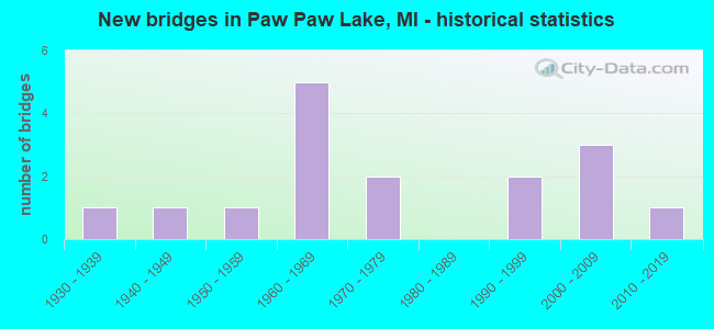
- New bridges - historical statistics
- 11930-1939
- 11940-1949
- 11950-1959
- 51960-1969
- 21970-1979
- 21990-1999
- 32000-2009
- 12010-2019


- Bridge Condition - Deck
- 7.7%Excellent
- 53.8%Good
- 15.4%Satisfactory
- 15.4%Fair
- 7.7%Poor

- Bridge Condition - Superstructure
- 23.1%Very good
- 15.4%Good
- 38.5%Satisfactory
- 23.1%Fair

- Bridge Condition - Substructure
- 15.4%Very good
- 61.5%Good
- 15.4%Satisfactory
- 7.7%Fair

- Bridge Condition - Channel
- 30.0%Very good
- 30.0%Good
- 30.0%Satisfactory
- 10.0%Fair
Find on map >> Show street view
Structure Number: 85, Location: 5.6 MI E OF I-196 (Lat: 42.177022, Lng: -86.281308), Route carried "on" structure: Interstate 94, Year Built: 1960, Status: Open, Structure Length: 4.08m (13.39ft), Average Daily Traffic: 14,416 (year 2007), Truck Traffic: 25%, Average Future Daily Traffic: 21,262 (year 2018), Design Load: HS 20+Mod, Features Intersected: HENNESSY ROAD
Minimum Vertical Clearance: 30.48m (100.00ft), Kilometerpoint: 1.980, Lanes on structure: 2, Lanes under structure: 2, Base Highway Network: Yes (Inventory Route: 136, Subroute: 5), Owner: State Highway Agency, Approaching Roadway Width: 12.6m (41.3ft), Material/Design: Concrete continuous, Design/Construction: Tee Beam, Number Of Spans In Main Unit: 3, Length of Maximum Span: 16.1m (52.8ft), Curb-To-Curb Width: 13.0m (42.7ft), Out-to-Out Width: 14.4m (47.2ft)
Condition: Deck: Fair, Superstructure: Satisfactory, Substructure: Satisfactory, Operating Rating: 60.6 metric tons, Method Used To Determine Operating Rating: Load Factor (LF) rating reported by rating factor (RF) method using MS18 loading, Inventory Rating: 35.0 metric tons, Method Used To Determine Inventory Rating: Load Factor (LF) rating reported by rating factor (RF) method using MS18 loading, Structural Evaluation: Equal to present minimum criteria, Deck Geometry: Superior to present desirable criteria, Underclear: Meets minimum limits, Approach Roadway Alignment: Better than present minimum criteria, Designated Inspection Frequency: Every 24 months, Inspection Date: June 2020, Deck Structure Type: Concrete Cast-file-Place, Wearing Surface/Protective System: Wearing Surface: Epoxy Overlay
Find on map >> Show street view
Structure Number: 851, Location: 5.6 MI E OF I-196 (Lat: 42.177286, Lng: -86.281311), Route carried "on" structure: Interstate 94, Year Built: 1960, Status: Open, Structure Length: 4.08m (13.39ft), Average Daily Traffic: 14,416 (year 2007), Truck Traffic: 25%, Average Future Daily Traffic: 21,262 (year 2018), Design Load: HS 20+Mod, Features Intersected: HENNESSY ROAD
Minimum Vertical Clearance: 30.48m (100.00ft), Kilometerpoint: 1.970, Lanes on structure: 2, Lanes under structure: 2, Base Highway Network: Yes (Inventory Route: 136, Subroute: 6), Owner: State Highway Agency, Approaching Roadway Width: 11.6m (38.1ft), Material/Design: Concrete continuous, Design/Construction: Tee Beam, Number Of Spans In Main Unit: 3, Length of Maximum Span: 16.1m (52.8ft), Curb-To-Curb Width: 13.0m (42.7ft), Out-to-Out Width: 14.4m (47.2ft)
Condition: Deck: Fair, Superstructure: Satisfactory, Substructure: Good, Operating Rating: 59.6 metric tons, Method Used To Determine Operating Rating: Load Factor (LF) rating reported by rating factor (RF) method using MS18 loading, Inventory Rating: 34.3 metric tons, Method Used To Determine Inventory Rating: Load Factor (LF) rating reported by rating factor (RF) method using MS18 loading, Structural Evaluation: Equal to present minimum criteria, Deck Geometry: Superior to present desirable criteria, Underclear: Meets minimum limits, Approach Roadway Alignment: Better than present minimum criteria, Designated Inspection Frequency: Every 24 months, Inspection Date: June 2020, Deck Structure Type: Concrete Cast-file-Place, Wearing Surface/Protective System: Wearing Surface: Epoxy Overlay
Find on map >> Show street view
Structure Number: 911, Location: 1.7 MI N OF WATERVLIET (Lat: 42.206881, Lng: -86.247508), Route carried "on" structure: State highway 140, Year Built: 1958, Status: Open, Structure Length: 1.22m (4.00ft), Average Daily Traffic: 5,018 (year 2007), Truck Traffic: 5%, Average Future Daily Traffic: 6,100 (year 2018), Design Load: HS 20, Features Intersected: PAW PAW LAKE OUTLET
Minimum Vertical Clearance: 30.48m (100.00ft), Kilometerpoint: 25.044, Lanes on structure: 2, Owner: State Highway Agency, Approaching Roadway Width: 12.9m (42.3ft), Skew: 1 degrees, Material/Design: Concrete, Design/Construction: Tee Beam, Number Of Spans In Main Unit: 1, Length of Maximum Span: 12.2m (40.0ft), Curb or Sidewalk Widths: Left: 0.2m (0.7ft), Right: 0.2m (0.7ft), Curb-To-Curb Width: 11.6m (38.1ft), Out-to-Out Width: 13.3m (43.6ft)
Condition: Deck: Poor, Superstructure: Fair, Substructure: Good, Channel: Satisfactory, Operating Rating: 60.3 metric tons, Method Used To Determine Operating Rating: Load Factor (LF) rating reported by rating factor (RF) method using MS18 loading, Inventory Rating: 36.0 metric tons, Method Used To Determine Inventory Rating: Load Factor (LF) rating reported by rating factor (RF) method using MS18 loading, Structural Evaluation: Somewhat better than minimum adequacy, Deck Geometry: Somewhat better than minimum adequacy, Waterway Adequacy: Equal to present minimum criteria, Approach Roadway Alignment: Better than present minimum criteria, Designated Inspection Frequency: Every 24 months, Inspection Date: June 2020, Deck Structure Type: Concrete Cast-file-Place, Wearing Surface/Protective System: Wearing Surface: Monolithic Concrete
Find on map >> Show street view
Structure Number: 998, Location: E CITY LIMIT COLOMA (Lat: 42.193128, Lng: -86.302133), Route carried "on" structure: County highway 1175, Year Built: 2002, Status: Open, Structure Length: 6.22m (20.41ft), Average Daily Traffic: 11,555 (year 2007), Truck Traffic: 4%, Average Future Daily Traffic: 14,000 (year 2027), Design Load: HS 20, Features Intersected: PAW PAW RIVER, Facility Carried by Structure: PAW PAW LAKE ROAD
Minimum Vertical Clearance: 30.48m (100.00ft), Kilometerpoint: 6.402, Lanes on structure: 4, Owner: County Highway Agency, Approaching Roadway Width: 18.9m (62.0ft), Skew: 4 degrees, Material/Design: Prestressed concrete, Design/Construction: Stringer/Multi-beam, Number Of Spans In Main Unit: 3, Length of Maximum Span: 22.8m (74.8ft), Curb or Sidewalk Widths: Left: 1.5m (4.9ft), Right: 1.5m (4.9ft), Curb-To-Curb Width: 15.9m (52.2ft), Out-to-Out Width: 19.6m (64.3ft)
Condition: Deck: Good, Superstructure: Very good, Substructure: Good, Channel: Good, Operating Rating: 60.9 metric tons, Method Used To Determine Operating Rating: Load Factor (LF) rating reported by rating factor (RF) method using MS18 loading, Inventory Rating: 36.6 metric tons, Method Used To Determine Inventory Rating: Load Factor (LF) rating reported by rating factor (RF) method using MS18 loading, Structural Evaluation: Better than present minimum criteria, Deck Geometry: Meets minimum limits, Waterway Adequacy: Equal to present minimum criteria, Approach Roadway Alignment: Equal to present desirable criteria, Designated Inspection Frequency: Every 24 months, Underwater Inspection Frequency: Every 60 months, Inspection Date: June 2020, Underwater Inspection Date: June 2018, Deck Structure Type: Concrete Cast-file-Place, Wearing Surface/Protective System: Wearing Surface: Monolithic Concrete
Find on map >> Show street view
Structure Number: 999, Location: 1.0 MI N OF WATERVLIET (Lat: 42.207800, Lng: -9.030556), Route carried "on" structure: County highway , Year Built: 2008, Status: Open, Structure Length: 1.72m (5.64ft), Average Daily Traffic: 800 (year 2007), Truck Traffic: 4%, Average Future Daily Traffic: 2,000 (year 2027), Design Load: HS 20, Features Intersected: PAW PAW LAKE OUTLET, Facility Carried by Structure: N WATERVLIET ROAD
Minimum Vertical Clearance: 30.48m (100.00ft), Kilometerpoint: 2.380, Lanes on structure: 2, Owner: County Highway Agency, Approaching Roadway Width: 12.8m (42.0ft), Material/Design: Prestressed concrete, Design/Construction: Stringer/Multi-beam, Number Of Spans In Main Unit: 1, Length of Maximum Span: 16.6m (54.5ft), Curb-To-Curb Width: 12.2m (40.0ft), Out-to-Out Width: 13.3m (43.6ft)
Condition: Deck: Good, Superstructure: Very good, Substructure: Good, Channel: Very good, Operating Rating: 69.0 metric tons, Method Used To Determine Operating Rating: Load Factor (LF) rating reported by rating factor (RF) method using MS18 loading, Inventory Rating: 41.5 metric tons, Method Used To Determine Inventory Rating: Load Factor (LF) rating reported by rating factor (RF) method using MS18 loading, Structural Evaluation: Better than present minimum criteria, Deck Geometry: Equal to present desirable criteria, Waterway Adequacy: Equal to present desirable criteria, Approach Roadway Alignment: Equal to present minimum criteria, Designated Inspection Frequency: Every 24 months, Inspection Date: June 2020, Deck Structure Type: Concrete Cast-file-Place, Wearing Surface/Protective System: Wearing Surface: Monolithic Concrete, Deck Protection: Epoxy Coated Reinforcing
Find on map >> Show street view
Structure Number: 1012, Location: W END PAW PAW LAKE (Lat: 42.200431, Lng: -86.291192), Route carried "on" structure: County highway , Year Built: 1994, Status: Open, Structure Length: 1.82m (5.97ft), Average Daily Traffic: 126 (year 2007), Truck Traffic: 4%, Average Future Daily Traffic: 500 (year 2027), Design Load: HS 20, Features Intersected: PAW PAW LAKE CHANNEL, Facility Carried by Structure: WIL-O-PAW ROAD
Minimum Vertical Clearance: 30.48m (100.00ft), Kilometerpoint: 0.117, Lanes on structure: 2, Owner: County Highway Agency, Approaching Roadway Width: 7.9m (25.9ft), Material/Design: Prestressed concrete, Design/Construction: Box Beam or Girders - Multiple, Number Of Spans In Main Unit: 1, Length of Maximum Span: 17.0m (55.8ft), Curb-To-Curb Width: 9.1m (29.9ft), Out-to-Out Width: 10.4m (34.1ft)
Condition: Deck: Good, Superstructure: Very good, Substructure: Very good, Channel: Very good, Operating Rating: 57.0 metric tons, Method Used To Determine Operating Rating: Load Factor (LF) rating reported by rating factor (RF) method using MS18 loading, Inventory Rating: 34.0 metric tons, Method Used To Determine Inventory Rating: Load Factor (LF) rating reported by rating factor (RF) method using MS18 loading, Structural Evaluation: Equal to present desirable criteria, Deck Geometry: Equal to present minimum criteria, Waterway Adequacy: Equal to present desirable criteria, Approach Roadway Alignment: Equal to present minimum criteria, Designated Inspection Frequency: Every 24 months, Inspection Date: July 2020, Deck Structure Type: Concrete Cast-file-Place, Wearing Surface/Protective System: Wearing Surface: Monolithic Concrete, Deck Protection: Epoxy Coated Reinforcing
Find on map >> Show street view
Structure Number: 1013, Location: SW PART PAW PAW LAKE (Lat: 42.196575, Lng: -86.291353), Route carried "on" structure: County highway , Year Built: 1993, Status: Open, Structure Length: 1.52m (4.99ft), Average Daily Traffic: 78 (year 2007), Truck Traffic: 1%, Average Future Daily Traffic: 300 (year 2027), Design Load: HS 20, Features Intersected: PAW PAW LAKE CHANNEL, Facility Carried by Structure: ISLAND COURT
Minimum Vertical Clearance: 30.48m (100.00ft), Kilometerpoint: 0.111, Lanes on structure: 2, Owner: County Highway Agency, Approaching Roadway Width: 9.1m (29.9ft), Material/Design: Prestressed concrete, Design/Construction: Box Beam or Girders - Multiple, Number Of Spans In Main Unit: 1, Length of Maximum Span: 14.6m (47.9ft), Curb-To-Curb Width: 9.4m (30.8ft), Out-to-Out Width: 10.4m (34.1ft)
Condition: Deck: Good, Superstructure: Satisfactory, Substructure: Very good, Channel: Very good, Operating Rating: 55.1 metric tons, Method Used To Determine Operating Rating: Load Factor (LF) rating reported by rating factor (RF) method using MS18 loading, Inventory Rating: 33.0 metric tons, Method Used To Determine Inventory Rating: Load Factor (LF) rating reported by rating factor (RF) method using MS18 loading, Structural Evaluation: Equal to present minimum criteria, Deck Geometry: Better than present minimum criteria, Waterway Adequacy: Equal to present desirable criteria, Approach Roadway Alignment: Better than present minimum criteria, Designated Inspection Frequency: Every 24 months, Inspection Date: July 2020, Deck Structure Type: Concrete Cast-file-Place, Wearing Surface/Protective System: Wearing Surface: Bituminous
Find on map >> Show street view
Structure Number: 2202, Location: FOSTER CITY (Lat: 45.965492, Lng: -87.742219), Route carried "on" structure: County highway 2273, Year Built: 1945, Status: Open, Structure Length: 1.06m (3.48ft), Average Daily Traffic: 453 (year 2020), Truck Traffic: 27%, Average Future Daily Traffic: 498 (year 2040), Features Intersected: E BR STURGEON RIVER, Facility Carried by Structure: COUNTY HWY 569
Minimum Vertical Clearance: 30.48m (100.00ft), Kilometerpoint: 26.793, Lanes on structure: 2, Owner: County Highway Agency, Approaching Roadway Width: 9.4m (30.8ft), Material/Design: Steel, Design/Construction: Stringer/Multi-beam, Number Of Spans In Main Unit: 1, Length of Maximum Span: 10.0m (32.8ft), Curb-To-Curb Width: 9.1m (29.9ft), Out-to-Out Width: 9.3m (30.5ft)
Condition: Deck: Satisfactory, Superstructure: Fair, Substructure: Fair, Channel: Satisfactory, Operating Rating: 51.5 metric tons, Method Used To Determine Operating Rating: Load Factor (LF) rating reported by rating factor (RF) method using MS18 loading, Inventory Rating: 25.9 metric tons, Method Used To Determine Inventory Rating: Load Factor (LF) rating reported by rating factor (RF) method using MS18 loading, Structural Evaluation: Somewhat better than minimum adequacy, Deck Geometry: Equal to present minimum criteria, Waterway Adequacy: Equal to present minimum criteria, Approach Roadway Alignment: Better than present minimum criteria, Length Of Structure Improvement: 1.30m (4.27ft), Designated Inspection Frequency: Every 24 months, Inspection Date: September 2020, Bridge Improvement Cost: $182,000, Roadway Improvement Cost: $18,000, Total Project Cost: $200,000, Deck Structure Type: Concrete Cast-file-Place, Wearing Surface/Protective System: Wearing Surface: Bituminous
Find on map >> Show street view
Structure Number: 4261, Location: @ US-127 BR N CLARE EXIT (Lat: 43.801386, Lng: -84.758739), Route carried "on" structure: Business US 127, Year Built: 1961, Year Reconstructed: 2019, Status: Open, Structure Length: 6.77m (22.21ft), Average Daily Traffic: 2,161 (year 2007), Truck Traffic: 5%, Average Future Daily Traffic: 3,490 (year 2018), Design Load: HS 20, Features Intersected: US-127 SB
Minimum Vertical Clearance: 30.48m (100.00ft), Kilometerpoint: 0.352, Lanes on structure: 2, Lanes under structure: 2, Owner: State Highway Agency, Approaching Roadway Width: 10.2m (33.5ft), Skew: 5 degrees, Material/Design: Steel, Design/Construction: Stringer/Multi-beam, Number Of Spans In Main Unit: 3, Length of Maximum Span: 31.1m (102.0ft), Curb-To-Curb Width: 10.2m (33.5ft), Out-to-Out Width: 11.2m (36.7ft)
Condition: Deck: Excellent, Superstructure: Satisfactory, Substructure: Good, Operating Rating: 68.4 metric tons, Method Used To Determine Operating Rating: Load Factor (LF) rating reported by rating factor (RF) method using MS18 loading, Inventory Rating: 40.8 metric tons, Method Used To Determine Inventory Rating: Load Factor (LF) rating reported by rating factor (RF) method using MS18 loading, Structural Evaluation: Equal to present minimum criteria, Deck Geometry: Somewhat better than minimum adequacy, Underclear: Meets minimum limits, Approach Roadway Alignment: Better than present minimum criteria, Designated Inspection Frequency: Every 24 months, Inspection Date: April 2021, Deck Structure Type: Concrete Cast-file-Place, Wearing Surface/Protective System: Wearing Surface: Monolithic Concrete, Deck Protection: Epoxy Coated Reinforcing
Find on map >> Show street view
Structure Number: 4721, Location: @ M-50 (Lat: 42.878592, Lng: -85.370975), Route carried "on" structure: State highway 50, Year Built: 2014, Status: Open, Structure Length: 6.04m (19.82ft), Average Daily Traffic: 11,100 (year 2012), Truck Traffic: 6%, Average Future Daily Traffic: 13,100 (year 2034), Design Load: Greater than HL93, Features Intersected: I-96
Minimum Vertical Clearance: 30.48m (100.00ft), Kilometerpoint: 0.101, Lanes on structure: 4, Lanes under structure: 4, Base Highway Network: Yes (Inventory Route: 341, Subroute: 48), Owner: State Highway Agency, Approaching Roadway Width: 21.2m (69.6ft), Material/Design: Prestressed concrete, Design/Construction: Box Beam or Girders - Single/Spread, Number Of Spans In Main Unit: 2, Length of Maximum Span: 21.6m (70.9ft), Curb-To-Curb Width: 20.7m (67.9ft), Out-to-Out Width: 21.7m (71.2ft)
Condition: Deck: Good, Superstructure: Satisfactory, Substructure: Good, Operating Rating: 62.5 metric tons, Method Used To Determine Operating Rating: Load and Resistance Factor Rating (LRFR) rating reported by rating factor(RF) method using HL-93 loadings, Inventory Rating: 42.1 metric tons, Method Used To Determine Inventory Rating: Load and Resistance Factor Rating (LRFR) rating reported by rating factor(RF) method using HL-93 loadings, Structural Evaluation: Equal to present minimum criteria, Deck Geometry: Superior to present desirable criteria, Underclear: Meets minimum limits, Approach Roadway Alignment: Equal to present desirable criteria, Designated Inspection Frequency: Every 24 months, Inspection Date: December 2020, Deck Structure Type: Concrete Cast-file-Place, Wearing Surface/Protective System: Wearing Surface: Monolithic Concrete, Deck Protection: Epoxy Coated Reinforcing
Find on map >> Show street view
Structure Number: 6601, Location: INTERSECTION OF HWY 550 (Lat: 46.727744, Lng: -87.623861), Route carried "on" structure: County highway , Year Built: 1935, Status: Open, Structure Length: 0.73m (2.40ft), Average Daily Traffic: 30 (year 2001), Average Future Daily Traffic: 30 (year 2020), Design Load: HS 20+Mod, Features Intersected: WILSON CREEK, Facility Carried by Structure: KCI ROAD
Minimum Vertical Clearance: 30.48m (100.00ft), Kilometerpoint: 0.655, Lanes on structure: 2, Owner: County Highway Agency, Approaching Roadway Width: 7.9m (25.9ft), Material/Design: Steel, Design/Construction: Stringer/Multi-beam, Number Of Spans In Main Unit: 1, Length of Maximum Span: 6.7m (22.0ft), Curb-To-Curb Width: 7.2m (23.6ft), Out-to-Out Width: 7.7m (25.3ft)
Condition: Deck: Satisfactory, Superstructure: Fair, Substructure: Good, Channel: Fair, Operating Rating: 79.1 metric tons, Method Used To Determine Operating Rating: Load Factor (LF), Inventory Rating: 37.3 metric tons, Method Used To Determine Inventory Rating: Load Factor (LF), Structural Evaluation: Somewhat better than minimum adequacy, Deck Geometry: Somewhat better than minimum adequacy, Waterway Adequacy: Somewhat better than minimum adequacy, Approach Roadway Alignment: Equal to present desirable criteria, Designated Inspection Frequency: Every 24 months, Inspection Date: October 2021, Deck Structure Type: Concrete Cast-file-Place, Wearing Surface/Protective System: Wearing Surface: Bituminous
Find on map >> Show street view
Structure Number: 6602, Location: 3 MI SW OF REPUBLIC (Lat: 46.377281, Lng: -88.027356), Route carried "on" structure: County highway , Year Built: 1978, Status: Open, Structure Length: 1.18m (3.87ft), Average Daily Traffic: 98 (year 2001), Average Future Daily Traffic: 120 (year 2020), Design Load: HS 20+Mod, Features Intersected: TROUT FALLS CREEK, Facility Carried by Structure: LB ROAD
Minimum Vertical Clearance: 30.48m (100.00ft), Kilometerpoint: 0.756, Lanes on structure: 2, Owner: County Highway Agency, Approaching Roadway Width: 7.9m (25.9ft), Material/Design: Prestressed concrete, Design/Construction: Box Beam or Girders - Multiple, Number Of Spans In Main Unit: 1, Length of Maximum Span: 10.9m (35.8ft), Curb-To-Curb Width: 8.9m (29.2ft), Out-to-Out Width: 9.2m (30.2ft)
Condition: Deck: Good, Superstructure: Good, Substructure: Good, Channel: Good, Operating Rating: 72.7 metric tons, Method Used To Determine Operating Rating: Load Factor (LF), Inventory Rating: 51.8 metric tons, Method Used To Determine Inventory Rating: Load Factor (LF), Structural Evaluation: Better than present minimum criteria, Deck Geometry: Better than present minimum criteria, Waterway Adequacy: Superior to present desirable criteria, Approach Roadway Alignment: Equal to present desirable criteria, Designated Inspection Frequency: Every 24 months, Inspection Date: October 2020, Deck Structure Type: Concrete Cast-file-Place, Wearing Surface/Protective System: Wearing Surface: Bituminous, Membrane: Preformed Fabric
Find on map >> Show street view
Structure Number: 10773, Location: 0.5 MI N OF RED ARROW HWY (Lat: 42.204903, Lng: -86.223189), Route carried "on" structure: County highway , Year Built: 1978, Status: Open, Structure Length: 4.39m (14.40ft), Average Daily Traffic: 621 (year 2019), Truck Traffic: 2%, Average Future Daily Traffic: 700 (year 2039), Design Load: HS 20, Features Intersected: PAW PAW RIVER, Facility Carried by Structure: 70TH STREET
Minimum Vertical Clearance: 30.48m (100.00ft), Kilometerpoint: 14.850, Lanes on structure: 2, Owner: County Highway Agency, Approaching Roadway Width: 11.0m (36.1ft), Skew: 4 degrees, Material/Design: Prestressed concrete, Design/Construction: Box Beam or Girders - Multiple, Number Of Spans In Main Unit: 3, Length of Maximum Span: 13.7m (44.9ft), Curb-To-Curb Width: 8.8m (28.9ft), Out-to-Out Width: 9.2m (30.2ft)
Condition: Deck: Good, Superstructure: Good, Substructure: Satisfactory, Channel: Satisfactory, Operating Rating: 60.3 metric tons, Method Used To Determine Operating Rating: Load Factor (LF) rating reported by rating factor (RF) method using MS18 loading, Inventory Rating: 36.0 metric tons, Method Used To Determine Inventory Rating: Load Factor (LF) rating reported by rating factor (RF) method using MS18 loading, Structural Evaluation: Equal to present minimum criteria, Deck Geometry: Somewhat better than minimum adequacy, Waterway Adequacy: Equal to present desirable criteria, Approach Roadway Alignment: Better than present minimum criteria, Designated Inspection Frequency: Every 24 months, Inspection Date: May 2020, Deck Structure Type: Concrete Precast Panels, Wearing Surface/Protective System: Wearing Surface: Bituminous, Membrane: Preformed Fabric
Find on map >> Show street view
Structure Number: 13092, Location: COLOMA TWP SEC 10-11 (Lat: 42.218239, Lng: -86.265553), Route carried "on" structure: County highway , Year Built: 2000, Status: Open, Structure Length: 0.61m (2.00ft), Average Daily Traffic: 1,172 (year 2007), Truck Traffic: 4%, Average Future Daily Traffic: 1,600 (year 2027), Design Load: H 20, Features Intersected: DERBY DRAIN, Facility Carried by Structure: PAW PAW LAKE ROAD
Minimum Vertical Clearance: 30.48m (100.00ft), Kilometerpoint: 11.945, Lanes on structure: 2, Base Highway Network: Yes (Inventory Route: 136, Subroute: 9), Owner: County Highway Agency, Approaching Roadway Width: 11.9m (39.0ft), Skew: 4 degrees, Material/Design: Concrete, Design/Construction: Culvert, Number Of Spans In Main Unit: 1, Length of Maximum Span: 6.1m (20.0ft)
Condition: Channel: Good, Culverts: Very good, Operating Rating: 54.5 metric tons, Method Used To Determine Operating Rating: Field evaluation and documented engineering judgment, Inventory Rating: 32.7 metric tons, Method Used To Determine Inventory Rating: Field evaluation and documented engineering judgment, Structural Evaluation: Equal to present desirable criteria, Waterway Adequacy: Better than present minimum criteria, Approach Roadway Alignment: Somewhat better than minimum adequacy, Designated Inspection Frequency: Every 24 months, Inspection Date: June 2020, Deck Structure Type: Concrete Precast Panels, Wearing Surface/Protective System: Wearing Surface: Bituminous
Find on map >> Show street view
Structure Number: 85, Location: 5.6 MI E OF I-196 (Lat: 42.177022, Lng: -86.281308), Route carried "under" structure: County highway , Year Built: 1960, Structure Length: 0. m, Average Daily Traffic: 300 (year 1974), Features Intersected: HENNESSY ROAD, Facility Carried by Structure: I-94 EB
Minimum Vertical Clearance: 5.33m (17.49ft), Kilometerpoint: 10.863, Lanes on structure: 2, Lanes under structure: 2, Material/Design: Concrete continuous, Design/Construction: Tee Beam, Length of Maximum Span: 16.1m (52.8ft)
Find on map >> Show street view
Structure Number: 851, Location: 5.6 MI E OF I-196 (Lat: 42.177286, Lng: -86.281311), Route carried "under" structure: County highway , Year Built: 1960, Structure Length: 0. m, Average Daily Traffic: 300 (year 1974), Features Intersected: HENNESSY ROAD, Facility Carried by Structure: I-94 WB
Minimum Vertical Clearance: 5.28m (17.32ft), Kilometerpoint: 10.892, Lanes on structure: 2, Lanes under structure: 2, Material/Design: Concrete continuous, Design/Construction: Tee Beam, Length of Maximum Span: 16.1m (52.8ft)