Bridge Statistics for Paton, Iowa (IA)
Condition, Traffic, Stress, Structural Evaluation, Project Costs
- National Bridge Inventory (NBI) Statistics
- 14Number of bridges
- 79ft / 24.1mTotal length
- 2,750Total average daily traffic
- 436Total average daily truck traffic
- 2,780Total future (year 2040) average daily traffic
- National Bridge Inventory (NBI) Registered Bridges for Paton
- No street view available for this location
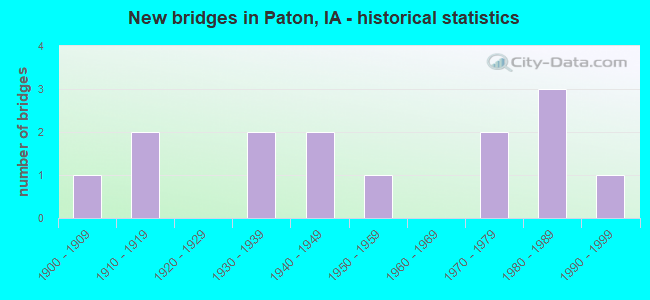
- New bridges - historical statistics
- 11900-1909
- 21910-1919
- 21930-1939
- 21940-1949
- 11950-1959
- 21970-1979
- 31980-1989
- 11990-1999

- Reconstructed bridges - Historical Statistics
- 41970-1979
- 11980-1989


- Bridge Condition - Deck
- 27.3%Good
- 45.5%Satisfactory
- 27.3%Fair

- Bridge Condition - Superstructure
- 9.1%Very good
- 18.2%Good
- 45.5%Satisfactory
- 27.3%Fair

- Bridge Condition - Substructure
- 27.3%Good
- 18.2%Satisfactory
- 36.4%Fair
- 18.2%Poor

- Bridge Condition - Channel
- 7.1%Very good
- 28.6%Good
- 50.0%Satisfactory
- 14.3%Fair

- Bridge Condition - Culverts
- 66.7%Good
- 33.3%Satisfactory
Find on map >> Show street view
Structure Number: 2577, Location: 6.7 MI. S OF JCT. IA 175 (Lat: 42.170186, Lng: -94.242742), Route carried "on" structure: State highway 144, Year Built: 1948, Status: Open, Structure Length: 3.81m (12.50ft), Average Daily Traffic: 530 (year 2020), Truck Traffic: 34%, Average Future Daily Traffic: 530 (year 2040), Design Load: H 20, Features Intersected: EAST BUTTRICK CREEK
Minimum Vertical Clearance: 30+ m (98+ ft), Kilometerpoint: 43.945, Lanes on structure: 2, Owner: State Highway Agency, Approaching Roadway Width: 9.8m (32.2ft), Material/Design: Steel continuous, Design/Construction: Stringer/Multi-beam, Number Of Spans In Main Unit: 3, Length of Maximum Span: 14.3m (46.9ft), Curb or Sidewalk Widths: Left: 0.6m (2.0ft), Right: 0.6m (2.0ft), Curb-To-Curb Width: 7.9m (25.9ft), Out-to-Out Width: 9.8m (32.2ft)
Condition: Deck: Fair, Superstructure: Satisfactory, Substructure: Fair, Channel: Fair, Operating Rating: 42.9 metric tons, Method Used To Determine Operating Rating: Allowable Stress (AS), Inventory Rating: 28.1 metric tons, Method Used To Determine Inventory Rating: Allowable Stress (AS), Structural Evaluation: Somewhat better than minimum adequacy, Deck Geometry: Somewhat better than minimum adequacy, Waterway Adequacy: Equal to present minimum criteria, Approach Roadway Alignment: Equal to present desirable criteria, Designated Inspection Frequency: Every 24 months, Underwater Inspection Frequency: Every 48 months, Inspection Date: June 2020, Underwater Inspection Date: June 2020, Deck Structure Type: Concrete Cast-file-Place, Wearing Surface/Protective System: Wearing Surface: Low Slump Concrete
Find on map >> Show street view
Structure Number: 2578, Location: 4.1 MI. S OF JCT. IA 175 (Lat: 42.208600, Lng: -94.242447), Route carried "on" structure: State highway 144, Year Built: 1948, Status: Open, Structure Length: 2.29m (7.51ft), Average Daily Traffic: 530 (year 2020), Truck Traffic: 34%, Average Future Daily Traffic: 530 (year 2040), Design Load: H 15, Features Intersected: EAST BUTTRICK CREEK
Minimum Vertical Clearance: 30+ m (98+ ft), Kilometerpoint: 48.210, Lanes on structure: 2, Owner: State Highway Agency, Approaching Roadway Width: 9.8m (32.2ft), Skew: 4 degrees, Material/Design: Steel, Design/Construction: Stringer/Multi-beam, Number Of Spans In Main Unit: 1, Length of Maximum Span: 21.0m (68.9ft), Curb or Sidewalk Widths: Left: 0.3m (1.0ft), Right: 0.3m (1.0ft), Curb-To-Curb Width: 9.1m (29.9ft), Out-to-Out Width: 9.7m (31.8ft)
Condition: Deck: Fair, Superstructure: Satisfactory, Substructure: Fair, Channel: Good, Operating Rating: 36.6 metric tons, Method Used To Determine Operating Rating: Allowable Stress (AS), Inventory Rating: 20.4 metric tons, Method Used To Determine Inventory Rating: Allowable Stress (AS), Structural Evaluation: Somewhat better than minimum adequacy, Deck Geometry: Equal to present minimum criteria, Waterway Adequacy: Equal to present minimum criteria, Approach Roadway Alignment: Equal to present desirable criteria, Designated Inspection Frequency: Every 24 months, Inspection Date: June 2020, Deck Structure Type: Concrete Cast-file-Place, Wearing Surface/Protective System: Wearing Surface: Low Slump Concrete
Find on map >> Show street view
Structure Number: 25791, Location: 085292003 (Lat: 42.166258, Lng: -94.244700), Route carried "on" structure: County highway , Year Built: 1994, Status: Open, Structure Length: 2.90m (9.51ft), Average Daily Traffic: 890 (year 2021), Average Future Daily Traffic: 890 (year 2040), Design Load: HS 20, Features Intersected: EAST BUTTRICK CREEK, Facility Carried by Structure: E 18 130TH ST
Minimum Vertical Clearance: 30+ m (98+ ft), Kilometerpoint: 27.809, Lanes on structure: 2, Owner: County Highway Agency, Approaching Roadway Width: 9.1m (29.9ft), Material/Design: Prestressed concrete, Design/Construction: Stringer/Multi-beam, Number Of Spans In Main Unit: 1, Length of Maximum Span: 29.0m (95.1ft), Curb-To-Curb Width: 9.3m (30.5ft), Out-to-Out Width: 9.8m (32.2ft)
Condition: Deck: Good, Superstructure: Very good, Substructure: Good, Channel: Fair, Operating Rating: 81.6 metric tons, Method Used To Determine Operating Rating: Load Factor (LF), Inventory Rating: 48.9 metric tons, Method Used To Determine Inventory Rating: Load Factor (LF), Structural Evaluation: Better than present minimum criteria, Deck Geometry: Equal to present minimum criteria, Waterway Adequacy: Equal to present desirable criteria, Approach Roadway Alignment: Equal to present desirable criteria, Designated Inspection Frequency: Every 24 months, Inspection Date: April 2020, Deck Structure Type: Concrete Cast-file-Place, Wearing Surface/Protective System: Wearing Surface: Monolithic Concrete
Find on map >> Show street view
Structure Number: 162961, Location: 085290401 (Lat: 42.209825, Lng: -94.227461), Route carried "on" structure: County highway , Year Built: 1914, Year Reconstructed: 1977, Status: Open, Structure Length: 0.70m (2.30ft), Average Daily Traffic: 20 (year 2015), Average Future Daily Traffic: 20 (year 2040), Design Load: H 20, Features Intersected: LOST GROVE CREEK, Facility Carried by Structure: 100 TH
Minimum Vertical Clearance: 30+ m (98+ ft), Kilometerpoint: 29.126, Lanes on structure: 2, Owner: County Highway Agency, Approaching Roadway Width: 7.3m (24.0ft), Material/Design: Concrete, Design/Construction: Slab, Number Of Spans In Main Unit: 1, Length of Maximum Span: 6.7m (22.0ft), Curb-To-Curb Width: 7.3m (24.0ft), Out-to-Out Width: 7.6m (24.9ft)
Condition: Deck: Fair, Superstructure: Fair, Substructure: Fair, Channel: Satisfactory, Operating Rating: 54.4 metric tons, Method Used To Determine Operating Rating: Allowable Stress (AS), Inventory Rating: 30.8 metric tons, Method Used To Determine Inventory Rating: Allowable Stress (AS), Structural Evaluation: Somewhat better than minimum adequacy, Deck Geometry: Equal to present minimum criteria, Waterway Adequacy: Equal to present minimum criteria, Approach Roadway Alignment: Equal to present desirable criteria, Length Of Structure Improvement: 4.40m (14.44ft), Designated Inspection Frequency: Every 24 months, Inspection Date: April 2020, Bridge Improvement Cost: $72,000, Roadway Improvement Cost: $11,000, Deck Structure Type: Concrete Cast-file-Place, Wearing Surface/Protective System: Wearing Surface: Gravel
Find on map >> Show street view
Structure Number: 162971, Location: 085290501 (Lat: 42.209800, Lng: -94.243686), Route carried "on" structure: County highway , Year Built: 1919, Year Reconstructed: 1977, Status: Open, Structure Length: 1.19m (3.90ft), Average Daily Traffic: 35 (year 2015), Average Future Daily Traffic: 35 (year 2040), Design Load: H 15, Features Intersected: EAST BUTTRICK CREEK, Facility Carried by Structure: 100TH ST
Minimum Vertical Clearance: 30+ m (98+ ft), Kilometerpoint: 27.787, Lanes on structure: 2, Owner: County Highway Agency, Approaching Roadway Width: 7.9m (25.9ft), Material/Design: Steel, Design/Construction: Stringer/Multi-beam, Number Of Spans In Main Unit: 1, Length of Maximum Span: 11.6m (38.1ft), Curb-To-Curb Width: 7.3m (24.0ft), Out-to-Out Width: 7.3m (24.0ft)
Condition: Deck: Satisfactory, Superstructure: Fair, Substructure: Fair, Channel: Satisfactory, Operating Rating: 89.8 metric tons, Method Used To Determine Operating Rating: Load Factor (LF), Inventory Rating: 61.7 metric tons, Method Used To Determine Inventory Rating: Load Factor (LF), Structural Evaluation: Somewhat better than minimum adequacy, Deck Geometry: Equal to present minimum criteria, Waterway Adequacy: Equal to present minimum criteria, Approach Roadway Alignment: Equal to present desirable criteria, Length Of Structure Improvement: 4.50m (14.76ft), Designated Inspection Frequency: Every 24 months, Inspection Date: April 2020, Bridge Improvement Cost: $39,000, Roadway Improvement Cost: $6,000, Deck Structure Type: Concrete Cast-file-Place, Wearing Surface/Protective System: Wearing Surface: Gravel
Find on map >> Show street view
Structure Number: 162981, Location: 085290901 (Lat: 42.195200, Lng: -94.240756), Route carried "on" structure: County highway , Year Built: 1983, Status: Open, Structure Length: 0.82m (2.69ft), Average Daily Traffic: 15 (year 2012), Truck Traffic: 7%, Average Future Daily Traffic: 15 (year 2040), Design Load: HS 20, Features Intersected: EAST BUTTRICKS CREEK, Facility Carried by Structure: 110 TH
Minimum Vertical Clearance: 30+ m (98+ ft), Kilometerpoint: 30.433, Lanes on structure: 2, Owner: County Highway Agency, Approaching Roadway Width: 7.3m (24.0ft), Skew: 3 degrees, Material/Design: Concrete, Design/Construction: Culvert, Number Of Spans In Main Unit: 2, Length of Maximum Span: 3.7m (12.1ft)
Condition: Channel: Good, Culverts: Good, Operating Rating: 45.7 metric tons, Method Used To Determine Operating Rating: Field evaluation and documented engineering judgment, Inventory Rating: 32.7 metric tons, Method Used To Determine Inventory Rating: Field evaluation and documented engineering judgment, Structural Evaluation: Better than present minimum criteria, Waterway Adequacy: Equal to present desirable criteria, Approach Roadway Alignment: Equal to present desirable criteria, Length Of Structure Improvement: 3.00m (9.84ft), Designated Inspection Frequency: Every 24 months, Inspection Date: April 2020, Bridge Improvement Cost: $17,000, Roadway Improvement Cost: $2,000
Find on map >> Show street view
Structure Number: 162991, Location: 085291601 (Lat: 42.180722, Lng: -94.235089), Route carried "on" structure: County highway , Year Built: 1979, Status: Open, Structure Length: 2.35m (7.71ft), Average Daily Traffic: 15 (year 2012), Average Future Daily Traffic: 15 (year 2040), Design Load: H 20, Features Intersected: BUTTRICKS CREEK, Facility Carried by Structure: 120 TH
Minimum Vertical Clearance: 30+ m (98+ ft), Kilometerpoint: 27.766, Lanes on structure: 2, Owner: County Highway Agency, Approaching Roadway Width: 7.9m (25.9ft), Material/Design: Concrete continuous, Design/Construction: Slab, Number Of Spans In Main Unit: 3, Length of Maximum Span: 8.8m (28.9ft), Curb-To-Curb Width: 8.5m (27.9ft), Out-to-Out Width: 9.1m (29.9ft)
Condition: Deck: Good, Superstructure: Good, Substructure: Good, Channel: Good, Operating Rating: 37.3 metric tons, Method Used To Determine Operating Rating: Load Factor (LF), Inventory Rating: 22.3 metric tons, Method Used To Determine Inventory Rating: Load Factor (LF), Structural Evaluation: Equal to present minimum criteria, Deck Geometry: Better than present minimum criteria, Waterway Adequacy: Better than present minimum criteria, Approach Roadway Alignment: Better than present minimum criteria, Length Of Structure Improvement: 7.70m (25.26ft), Designated Inspection Frequency: Every 24 months, Inspection Date: April 2020, Bridge Improvement Cost: $92,000, Roadway Improvement Cost: $3,000, Deck Structure Type: Concrete Cast-file-Place, Wearing Surface/Protective System: Wearing Surface: Gravel
Find on map >> Show street view
Structure Number: 16301, Location: 085292901 (Lat: 42.151703, Lng: -94.259822), Route carried "on" structure: County highway , Year Built: 1934, Year Reconstructed: 1989, Status: Posted for load, Structure Length: 1.74m (5.71ft), Average Daily Traffic: 10 (year 2012), Average Future Daily Traffic: 10 (year 2040), Features Intersected: STREAM, Facility Carried by Structure: 140 TH
Minimum Vertical Clearance: 30+ m (98+ ft), Kilometerpoint: 27.101, Lanes on structure: 2, Owner: County Highway Agency, Approaching Roadway Width: 7.3m (24.0ft), Material/Design: Steel, Design/Construction: Stringer/Multi-beam, Number Of Spans In Main Unit: 2, Length of Maximum Span: 8.8m (28.9ft), Curb-To-Curb Width: 6.0m (19.7ft), Out-to-Out Width: 6.3m (20.7ft)
Condition: Deck: Satisfactory, Superstructure: Satisfactory, Substructure: Satisfactory, Channel: Satisfactory, Operating Rating: 30.8 metric tons, Method Used To Determine Operating Rating: Load Factor (LF), Inventory Rating: 18.1 metric tons, Method Used To Determine Inventory Rating: Load Factor (LF), Structural Evaluation: Somewhat better than minimum adequacy, Deck Geometry: Meets minimum limits, Waterway Adequacy: Equal to present minimum criteria, Approach Roadway Alignment: Equal to present minimum criteria, Bridge Posting: Required (Relationship of Operating Rating to Maximum Legal Load: 0.1 - 9.9% below), Length Of Structure Improvement: 8.00m (26.25ft), Designated Inspection Frequency: Every 24 months, Inspection Date: April 2020, Bridge Improvement Cost: $130,000, Roadway Improvement Cost: $20,000, Deck Structure Type: Wood or Timber, Wearing Surface/Protective System: Wearing Surface: Gravel
Find on map >> Show street view
Structure Number: 163021, Location: 085293103 (Lat: 42.137222, Lng: -94.262817), Route carried "on" structure: County highway , Year Built: 1987, Status: Open, Structure Length: 2.29m (7.51ft), Average Daily Traffic: 40 (year 2012), Average Future Daily Traffic: 40 (year 2040), Design Load: HS 20, Features Intersected: EAST BUTTRICKS CREEK, Facility Carried by Structure: 150 TH
Minimum Vertical Clearance: 30+ m (98+ ft), Kilometerpoint: 25.461, Lanes on structure: 2, Owner: County Highway Agency, Approaching Roadway Width: 7.3m (24.0ft), Material/Design: Concrete continuous, Design/Construction: Slab, Number Of Spans In Main Unit: 3, Length of Maximum Span: 8.8m (28.9ft), Curb-To-Curb Width: 7.5m (24.6ft), Out-to-Out Width: 8.3m (27.2ft)
Condition: Deck: Good, Superstructure: Good, Substructure: Good, Channel: Satisfactory, Operating Rating: 74.0 metric tons, Method Used To Determine Operating Rating: Load Factor (LF), Inventory Rating: 44.4 metric tons, Method Used To Determine Inventory Rating: Load Factor (LF), Structural Evaluation: Better than present minimum criteria, Deck Geometry: Equal to present minimum criteria, Waterway Adequacy: Equal to present desirable criteria, Approach Roadway Alignment: Somewhat better than minimum adequacy, Designated Inspection Frequency: Every 24 months, Inspection Date: April 2020, Deck Structure Type: Concrete Cast-file-Place, Wearing Surface/Protective System: Wearing Surface: Gravel
Find on map >> Show street view
Structure Number: 163031, Location: 085293301 (Lat: 42.137308, Lng: -94.238019), Route carried "on" structure: County highway , Year Built: 1979, Status: Open, Structure Length: 0.64m (2.10ft), Average Daily Traffic: 20 (year 2012), Truck Traffic: 15%, Average Future Daily Traffic: 20 (year 2040), Design Load: H 20, Features Intersected: DEVILS FORK, Facility Carried by Structure: 150 TH
Minimum Vertical Clearance: 30+ m (98+ ft), Kilometerpoint: 27.510, Lanes on structure: 2, Owner: County Highway Agency, Approaching Roadway Width: 7.9m (25.9ft), Material/Design: Concrete continuous, Design/Construction: Culvert, Number Of Spans In Main Unit: 2, Length of Maximum Span: 3.0m (9.8ft)
Condition: Channel: Satisfactory, Culverts: Good, Operating Rating: 66.8 metric tons, Method Used To Determine Operating Rating: Load Factor (LF), Inventory Rating: 40.0 metric tons, Method Used To Determine Inventory Rating: Load Factor (LF), Structural Evaluation: Better than present minimum criteria, Waterway Adequacy: Equal to present minimum criteria, Approach Roadway Alignment: Equal to present desirable criteria, Length Of Structure Improvement: 2.10m (6.89ft), Designated Inspection Frequency: Every 24 months, Inspection Date: April 2020, Bridge Improvement Cost: $63,000, Roadway Improvement Cost: $6,000
Find on map >> Show street view
Structure Number: 16307, Location: 085301101 (Lat: 42.194933, Lng: -94.315642), Route carried "on" structure: County highway , Year Built: 1934, Year Reconstructed: 1982, Status: Open, Structure Length: 0.64m (2.10ft), Average Daily Traffic: 10 (year 2012), Average Future Daily Traffic: 10 (year 2040), Features Intersected: STREAM, Facility Carried by Structure: 110 TH
Minimum Vertical Clearance: 30+ m (98+ ft), Kilometerpoint: 25.857, Lanes on structure: 2, Owner: County Highway Agency, Approaching Roadway Width: 7.9m (25.9ft), Material/Design: Steel, Design/Construction: Stringer/Multi-beam, Number Of Spans In Main Unit: 1, Length of Maximum Span: 6.4m (21.0ft), Curb-To-Curb Width: 6.6m (21.7ft), Out-to-Out Width: 6.9m (22.6ft)
Condition: Deck: Satisfactory, Superstructure: Satisfactory, Substructure: Satisfactory, Channel: Good, Operating Rating: 37.2 metric tons, Method Used To Determine Operating Rating: Load Factor (LF), Inventory Rating: 21.8 metric tons, Method Used To Determine Inventory Rating: Load Factor (LF), Structural Evaluation: Equal to present minimum criteria, Deck Geometry: Somewhat better than minimum adequacy, Waterway Adequacy: Better than present minimum criteria, Approach Roadway Alignment: Equal to present desirable criteria, Length Of Structure Improvement: 2.20m (7.22ft), Designated Inspection Frequency: Every 24 months, Inspection Date: April 2020, Bridge Improvement Cost: $11,000, Roadway Improvement Cost: $1,000, Deck Structure Type: Wood or Timber, Wearing Surface/Protective System: Wearing Surface: Wood or Timber
Find on map >> Show street view
Structure Number: 163111, Location: 085302302 (Lat: 42.162056, Lng: -94.320061), Route carried "on" structure: ServiceCounty highway , Year Built: 1900, Year Reconstructed: 1979, Status: Open, Structure Length: 1.77m (5.81ft), Average Daily Traffic: 10 (year 2012), Average Future Daily Traffic: 40 (year 2040), Features Intersected: BUTTRICKS CREEK, Facility Carried by Structure: FARM DRIVE
Minimum Vertical Clearance: 30+ m (98+ ft), Kilometerpoint: 18.419, Lanes on structure: 2, Owner: County Highway Agency, Approaching Roadway Width: 6.1m (20.0ft), Material/Design: Steel, Design/Construction: Stringer/Multi-beam, Number Of Spans In Main Unit: 3, Length of Maximum Span: 7.9m (25.9ft), Curb-To-Curb Width: 6.1m (20.0ft), Out-to-Out Width: 6.1m (20.0ft)
Condition: Deck: Satisfactory, Superstructure: Fair, Substructure: Poor, Channel: Satisfactory, Operating Rating: 39.0 metric tons, Method Used To Determine Operating Rating: Load Factor (LF), Inventory Rating: 23.6 metric tons, Method Used To Determine Inventory Rating: Load Factor (LF), Structural Evaluation: Meets minimum limits, Deck Geometry: Somewhat better than minimum adequacy, Waterway Adequacy: Better than present minimum criteria, Approach Roadway Alignment: Equal to present minimum criteria, Designated Inspection Frequency: Every 24 months, Inspection Date: April 2020, Bridge Improvement Cost: $1,000, Roadway Improvement Cost: $1,000, Deck Structure Type: Wood or Timber, Wearing Surface/Protective System: Wearing Surface: Wood or Timber
Find on map >> Show street view
Structure Number: 16312, Location: 085302701 (Lat: 42.151683, Lng: -94.322000), Route carried "on" structure: County highway , Year Built: 1956, Status: Posted for load, Structure Length: 2.35m (7.71ft), Average Daily Traffic: 25 (year 2012), Average Future Daily Traffic: 25 (year 2040), Design Load: H 15, Features Intersected: STREAM, Facility Carried by Structure: 140 TH
Minimum Vertical Clearance: 30+ m (98+ ft), Kilometerpoint: 23.530, Lanes on structure: 2, Owner: County Highway Agency, Approaching Roadway Width: 7.9m (25.9ft), Material/Design: Concrete continuous, Design/Construction: Slab, Number Of Spans In Main Unit: 3, Length of Maximum Span: 8.8m (28.9ft), Curb-To-Curb Width: 6.2m (20.3ft), Out-to-Out Width: 6.7m (22.0ft)
Condition: Deck: Satisfactory, Superstructure: Satisfactory, Substructure: Poor, Channel: Satisfactory, Operating Rating: 31.4 metric tons, Method Used To Determine Operating Rating: Load Factor (LF), Inventory Rating: 18.8 metric tons, Method Used To Determine Inventory Rating: Load Factor (LF), Structural Evaluation: Meets minimum limits, Deck Geometry: Somewhat better than minimum adequacy, Waterway Adequacy: Better than present minimum criteria, Approach Roadway Alignment: Better than present minimum criteria, Bridge Posting: Required (Relationship of Operating Rating to Maximum Legal Load: 10.0 - 19.9% below), Length Of Structure Improvement: 10.50m (34.45ft), Designated Inspection Frequency: Every 24 months, Inspection Date: April 2020, Bridge Improvement Cost: $171,000, Roadway Improvement Cost: $26,000, Deck Structure Type: Concrete Cast-file-Place, Wearing Surface/Protective System: Wearing Surface: Monolithic Concrete
Find on map >> Show street view
Structure Number: 362585, Location: 085302401 (Lat: 42.166061, Lng: -94.286603), Route carried "on" structure: County highway , Year Built: 1985, Status: Open, Structure Length: 0.64m (2.10ft), Average Daily Traffic: 600 (year 2016), Truck Traffic: 12%, Average Future Daily Traffic: 600 (year 2040), Design Load: HS 20, Features Intersected: SMALL STREAM, Facility Carried by Structure: E18
Minimum Vertical Clearance: 30+ m (98+ ft), Kilometerpoint: 25.552, Lanes on structure: 2, Owner: County Highway Agency, Approaching Roadway Width: 9.1m (29.9ft), Material/Design: Concrete, Design/Construction: Culvert, Number Of Spans In Main Unit: 2, Length of Maximum Span: 3.0m (9.8ft)
Condition: Channel: Very good, Culverts: Satisfactory, Operating Rating: 45.7 metric tons, Method Used To Determine Operating Rating: Field evaluation and documented engineering judgment, Inventory Rating: 32.7 metric tons, Method Used To Determine Inventory Rating: Field evaluation and documented engineering judgment, Structural Evaluation: Equal to present minimum criteria, Waterway Adequacy: Equal to present desirable criteria, Approach Roadway Alignment: Equal to present desirable criteria, Length Of Structure Improvement: 2.10m (6.89ft), Designated Inspection Frequency: Every 24 months, Inspection Date: April 2020, Bridge Improvement Cost: $22,000, Roadway Improvement Cost: $2,000