Bridge Statistics for Parowan, Utah (UT)
Condition, Traffic, Stress, Structural Evaluation, Project Costs
- National Bridge Inventory (NBI) Statistics
- 14Number of bridges
- 118ft / 36.0mTotal length
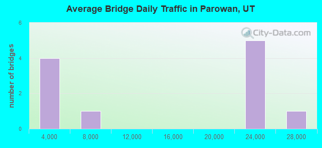
- 141,410Total average daily traffic
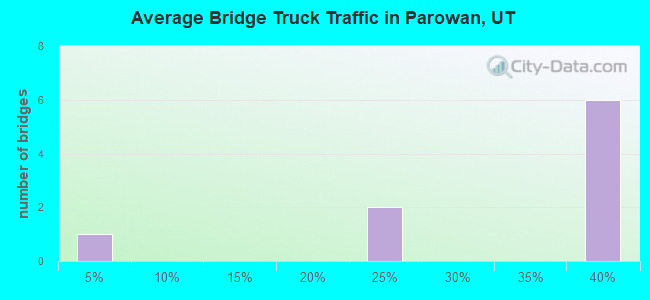
- 48,670Total average daily truck traffic
- National Bridge Inventory (NBI) Registered Bridges for Parowan
- No street view available for this location
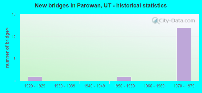
- New bridges - historical statistics
- 11920-1929
- 11950-1959
- 121970-1979
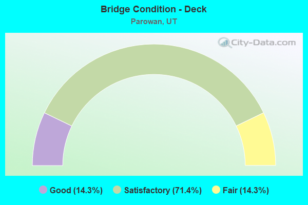
- Bridge Condition - Deck
- 14.3%Good
- 71.4%Satisfactory
- 14.3%Fair
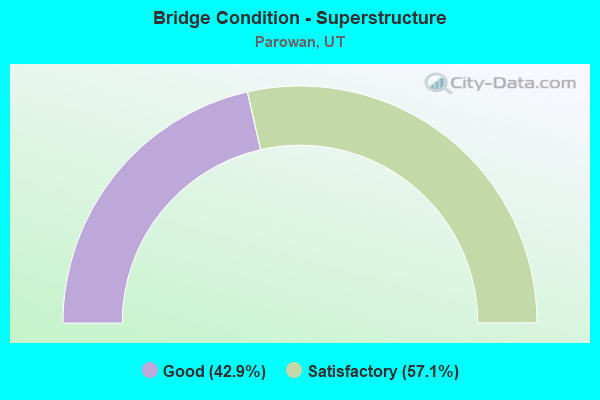
- Bridge Condition - Superstructure
- 42.9%Good
- 57.1%Satisfactory
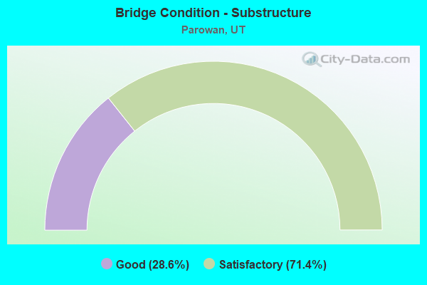
- Bridge Condition - Substructure
- 28.6%Good
- 71.4%Satisfactory
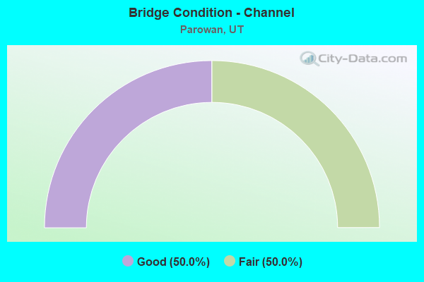
- Bridge Condition - Channel
- 50.0%Good
- 50.0%Fair
Find on map >> Show street view
Structure Number: 21004D, Location: SOUTH END PAROWAN MAIN ST (Lat: 37.837439, Lng: -112.827725), Route carried "on" structure: City street 1786, Year Built: 1925, Year Reconstructed: 1938, Status: Posted for load, Structure Length: 1.25m (4.10ft), Average Daily Traffic: 3,800 (year 2020), Truck Traffic: 2%, Average Future Daily Traffic: 4,750 (year 2040), Design Load: H 15, Features Intersected: PAROWAN CREEK, Facility Carried by Structure: PAROWAN MAIN ST.
Minimum Vertical Clearance: 30+ m (98+ ft), Kilometerpoint: 11.264, Lanes on structure: 2, Owner: City or Municipal Highway Agency, Approaching Roadway Width: 9.1m (29.9ft), Skew: 2 degrees, Material/Design: Concrete, Design/Construction: Tee Beam, Number Of Spans In Main Unit: 1, Length of Maximum Span: 10.4m (34.1ft), Curb-To-Curb Width: 9.1m (29.9ft), Out-to-Out Width: 9.5m (31.2ft)
Condition: Deck: Satisfactory, Superstructure: Good, Substructure: Good, Channel: Good, Operating Rating: 32.4 metric tons, Method Used To Determine Operating Rating: Load Factor (LF) rating reported by rating factor (RF) method using MS18 loading, Inventory Rating: 21.1 metric tons, Method Used To Determine Inventory Rating: Load Factor (LF) rating reported by rating factor (RF) method using MS18 loading, Structural Evaluation: Somewhat better than minimum adequacy, Deck Geometry: Meets minimum limits, Waterway Adequacy: Better than present minimum criteria, Approach Roadway Alignment: Meets minimum limits, Designated Inspection Frequency: Every 24 months, Inspection Date: March 2020, Deck Structure Type: Concrete Cast-file-Place, Wearing Surface/Protective System: Wearing Surface: Bituminous
Find on map >> Show street view
Structure Number: 21009D, Location: SOUTH END PAROWAN MAIN ST (Lat: 37.837442, Lng: -112.827275), Route carried "on" structure: City street , Year Built: 1950, Status: Posted for load, Structure Length: 0.79m (2.59ft), Average Daily Traffic: 63 (year 2020), Average Future Daily Traffic: 77 (year 2040), Design Load: H 15, Features Intersected: PAROWAN CREEK, Facility Carried by Structure: PAROWAN CITY ST.
Minimum Vertical Clearance: 30+ m (98+ ft), Kilometerpoint: 0.086, Lanes on structure: 1, Owner: City or Municipal Highway Agency, Approaching Roadway Width: 3.0m (9.8ft), Material/Design: Concrete, Design/Construction: Slab, Number Of Spans In Main Unit: 1, Length of Maximum Span: 7.3m (24.0ft), Curb-To-Curb Width: 3.0m (9.8ft), Out-to-Out Width: 3.7m (12.1ft)
Condition: Deck: Good, Superstructure: Good, Substructure: Good, Channel: Fair, Operating Rating: 31.8 metric tons, Method Used To Determine Operating Rating: Load Factor (LF) rating reported by rating factor (RF) method using MS18 loading, Inventory Rating: 19.4 metric tons, Method Used To Determine Inventory Rating: Load Factor (LF) rating reported by rating factor (RF) method using MS18 loading, Structural Evaluation: Somewhat better than minimum adequacy, Deck Geometry: High priority of replacement, Waterway Adequacy: Equal to present minimum criteria, Approach Roadway Alignment: Somewhat better than minimum adequacy, Bridge Posting: Required (Relationship of Operating Rating to Maximum Legal Load: 0.1 - 9.9% below), Designated Inspection Frequency: Every 24 months, Inspection Date: March 2020, Deck Structure Type: Concrete Cast-file-Place, Wearing Surface/Protective System: Wearing Surface: Bituminous
Find on map >> Show street view
Structure Number: C 537, Location: SO.PAROWAN INTERCHANGE (Lat: 37.839517, Lng: -112.869650), Route carried "on" structure: State highway 143, Year Built: 1973, Status: Open, Structure Length: 8.88m (29.13ft), Average Daily Traffic: 4,240 (year 2020), Truck Traffic: 20%, Average Future Daily Traffic: 5,300 (year 2040), Design Load: HS 20+Mod, Features Intersected: I-15 (SR-15) NBL AND SBL
Minimum Vertical Clearance: 30+ m (98+ ft), Kilometerpoint: 0.107, Lanes on structure: 2, Lanes under structure: 4, Owner: State Highway Agency, Approaching Roadway Width: 9.3m (30.5ft), Skew: 3 degrees, Material/Design: Steel continuous, Design/Construction: Stringer/Multi-beam, Number Of Spans In Main Unit: 2, Length of Maximum Span: 43.6m (143.0ft), Curb-To-Curb Width: 9.3m (30.5ft), Out-to-Out Width: 10.4m (34.1ft)
Condition: Deck: Fair, Superstructure: Satisfactory, Substructure: Satisfactory, Operating Rating: 78.4 metric tons, Method Used To Determine Operating Rating: Load and Resistance Factor Rating (LRFR) rating reported by rating factor(RF) method using HL-93 loadings, Inventory Rating: 42.1 metric tons, Method Used To Determine Inventory Rating: Load Factor (LF) rating reported by rating factor (RF) method using MS18 loading, Structural Evaluation: Equal to present minimum criteria, Deck Geometry: Meets minimum limits, Underclear: Somewhat better than minimum adequacy, Approach Roadway Alignment: Equal to present minimum criteria, Designated Inspection Frequency: Every 24 months, Inspection Date: March 2021, Deck Structure Type: Concrete Cast-file-Place, Wearing Surface/Protective System: Wearing Surface: Bituminous, Membrane: Preformed Fabric
Find on map >> Show street view
Structure Number: C 538, Location: NORTH PAROWAN INTERCHANGE (Lat: 37.858197, Lng: -112.828253), Route carried "on" structure: State highway 274, Year Built: 1973, Status: Open, Structure Length: 8.02m (26.31ft), Average Daily Traffic: 1,621 (year 2020), Truck Traffic: 22%, Average Future Daily Traffic: 2,026 (year 2040), Design Load: HS 20+Mod, Features Intersected: I-15 (SR-15) NBL & SBL
Minimum Vertical Clearance: 30+ m (98+ ft), Kilometerpoint: 1.783, Lanes on structure: 2, Lanes under structure: 4, Owner: State Highway Agency, Approaching Roadway Width: 15.4m (50.5ft), Skew: 1 degrees, Material/Design: Steel continuous, Design/Construction: Stringer/Multi-beam, Number Of Spans In Main Unit: 2, Length of Maximum Span: 39.9m (130.9ft), Curb-To-Curb Width: 15.4m (50.5ft), Out-to-Out Width: 16.4m (53.8ft)
Condition: Deck: Satisfactory, Superstructure: Good, Substructure: Satisfactory, Operating Rating: 83.9 metric tons, Method Used To Determine Operating Rating: Load and Resistance Factor Rating (LRFR) rating reported by rating factor(RF) method using HL-93 loadings, Inventory Rating: 40.2 metric tons, Method Used To Determine Inventory Rating: Load Factor (LF) rating reported by rating factor (RF) method using MS18 loading, Structural Evaluation: Equal to present minimum criteria, Deck Geometry: Superior to present desirable criteria, Underclear: Somewhat better than minimum adequacy, Approach Roadway Alignment: Equal to present minimum criteria, Designated Inspection Frequency: Every 24 months, Inspection Date: March 2021, Deck Structure Type: Concrete Cast-file-Place, Wearing Surface/Protective System: Wearing Surface: Bituminous, Membrane: Preformed Fabric
Find on map >> Show street view
Structure Number: E185, Location: 3.2 MI.NO.SO.PAROWAN INT (Lat: 37.865147, Lng: -112.821069), Route carried "on" structure: Interstate 15, Year Built: 1974, Status: Open, Structure Length: 0.73m (2.40ft), Average Daily Traffic: 20,827 (year 2020), Truck Traffic: 36%, Average Future Daily Traffic: 26,034 (year 2040), Design Load: HS 20+Mod, Features Intersected: CO.RD.TO KANES SPRING
Minimum Vertical Clearance: 30+ m (98+ ft), Kilometerpoint: 126.505, Lanes on structure: 4, Lanes under structure: 1, Base Highway Network: Yes, Owner: State Highway Agency, Approaching Roadway Width: 25.6m (84.0ft), Skew: 25 degrees, Material/Design: Concrete, Design/Construction: Culvert, Number Of Spans In Main Unit: 1, Length of Maximum Span: 6.9m (22.6ft), Curb-To-Curb Width: 25.6m (84.0ft), Out-to-Out Width: 91.3m (299.5ft)
Condition: Culverts: Satisfactory, Operating Rating: 32.7 metric tons, Method Used To Determine Operating Rating: Load and Resistance Factor Rating (LRFR) rating reported by rating factor(RF) method using HL-93 loadings, Inventory Rating: 31.8 metric tons, Method Used To Determine Inventory Rating: Load Factor (LF) rating reported by rating factor (RF) method using MS18 loading, Structural Evaluation: Equal to present minimum criteria, Deck Geometry: Superior to present desirable criteria, Underclear: High priority of corrective action, Approach Roadway Alignment: Equal to present desirable criteria, Designated Inspection Frequency: Every 24 months, Inspection Date: March 2021
Find on map >> Show street view
Structure Number: P 2, Location: 2.1 MI.NO.NO.PAROWAN INT. (Lat: 37.882381, Lng: -112.803947), Route carried "on" structure: County highway 1796, Year Built: 1973, Status: Open, Structure Length: 9.96m (32.68ft), Average Daily Traffic: 1,800 (year 2020), Average Future Daily Traffic: 2,250 (year 2040), Design Load: HS 20+Mod, Features Intersected: I-15 (SR-15) NBL AND SBL, Facility Carried by Structure: CO.RD.-BIG FIELDS
Minimum Vertical Clearance: 30+ m (98+ ft), Kilometerpoint: 11.504, Lanes on structure: 2, Lanes under structure: 4, Owner: State Highway Agency, Approaching Roadway Width: 9.3m (30.5ft), Skew: 3 degrees, Material/Design: Concrete continuous, Design/Construction: Box Beam or Girders - Multiple, Number Of Spans In Main Unit: 2, Length of Maximum Span: 48.6m (159.4ft), Curb-To-Curb Width: 9.3m (30.5ft), Out-to-Out Width: 10.5m (34.4ft)
Condition: Deck: Satisfactory, Superstructure: Satisfactory, Substructure: Satisfactory, Operating Rating: 36.3 metric tons, Method Used To Determine Operating Rating: Load and Resistance Factor Rating (LRFR) rating reported by rating factor(RF) method using HL-93 loadings, Inventory Rating: 24.6 metric tons, Method Used To Determine Inventory Rating: Load and Resistance Factor Rating (LRFR) rating reported by rating factor(RF) method using HL-93 loadings, Structural Evaluation: Equal to present minimum criteria, Deck Geometry: Somewhat better than minimum adequacy, Underclear: Superior to present desirable criteria, Approach Roadway Alignment: Equal to present minimum criteria, Designated Inspection Frequency: Every 24 months, Inspection Date: March 2021, Deck Structure Type: Concrete Cast-file-Place, Wearing Surface/Protective System: Wearing Surface: Monolithic Concrete
Find on map >> Show street view
Structure Number: 1F 26, Location: 1.5 MI.NO.SO.PAROWAN INT. (Lat: 37.848961, Lng: -112.843222), Route carried "on" structure: Interstate 15, Year Built: 1973, Status: Open, Structure Length: 3.21m (10.53ft), Average Daily Traffic: 21,208 (year 2020), Truck Traffic: 37%, Average Future Daily Traffic: 26,510 (year 2040), Design Load: HS 20+Mod, Features Intersected: CO. RD. TO PAROWAN GAP
Minimum Vertical Clearance: 30+ m (98+ ft), Kilometerpoint: 123.840, Lanes on structure: 2, Lanes under structure: 2, Base Highway Network: Yes, Owner: State Highway Agency, Approaching Roadway Width: 12.3m (40.4ft), Skew: 13 degrees, Material/Design: Prestressed concrete, Design/Construction: Stringer/Multi-beam, Number Of Spans In Main Unit: 1, Length of Maximum Span: 30.5m (100.1ft), Curb-To-Curb Width: 12.3m (40.4ft), Out-to-Out Width: 13.4m (44.0ft)
Condition: Deck: Satisfactory, Superstructure: Satisfactory, Substructure: Satisfactory, Operating Rating: 37.9 metric tons, Method Used To Determine Operating Rating: Load Factor (LF) rating reported by rating factor (RF) method using MS18 loading, Inventory Rating: 26.9 metric tons, Method Used To Determine Inventory Rating: Load Factor (LF) rating reported by rating factor (RF) method using MS18 loading, Structural Evaluation: Equal to present minimum criteria, Deck Geometry: Better than present minimum criteria, Underclear: Meets minimum limits, Approach Roadway Alignment: Equal to present desirable criteria, Designated Inspection Frequency: Every 24 months, Inspection Date: March 2021, Deck Structure Type: Concrete Cast-file-Place, Wearing Surface/Protective System: Wearing Surface: Bituminous, Membrane: Preformed Fabric
Find on map >> Show street view
Structure Number: 3F 26, Location: 1.5 MI.NO.SO.PAROWAN INT. (Lat: 37.849308, Lng: -112.843211), Route carried "on" structure: Interstate 15, Year Built: 1973, Status: Open, Structure Length: 3.21m (10.53ft), Average Daily Traffic: 21,208 (year 2020), Truck Traffic: 37%, Average Future Daily Traffic: 26,510 (year 2040), Design Load: HS 20+Mod, Features Intersected: CO. RD. TO PAROWAN GAP
Minimum Vertical Clearance: 30+ m (98+ ft), Kilometerpoint: 123.885, Lanes on structure: 2, Lanes under structure: 2, Base Highway Network: Yes, Owner: State Highway Agency, Approaching Roadway Width: 12.3m (40.4ft), Skew: 13 degrees, Material/Design: Prestressed concrete, Design/Construction: Stringer/Multi-beam, Number Of Spans In Main Unit: 1, Length of Maximum Span: 30.5m (100.1ft), Curb-To-Curb Width: 12.3m (40.4ft), Out-to-Out Width: 13.4m (44.0ft)
Condition: Deck: Satisfactory, Superstructure: Satisfactory, Substructure: Satisfactory, Operating Rating: 37.9 metric tons, Method Used To Determine Operating Rating: Load Factor (LF) rating reported by rating factor (RF) method using MS18 loading, Inventory Rating: 26.9 metric tons, Method Used To Determine Inventory Rating: Load Factor (LF) rating reported by rating factor (RF) method using MS18 loading, Structural Evaluation: Equal to present minimum criteria, Deck Geometry: Better than present minimum criteria, Underclear: Meets minimum limits, Approach Roadway Alignment: Equal to present desirable criteria, Designated Inspection Frequency: Every 24 months, Inspection Date: March 2021, Deck Structure Type: Concrete Cast-file-Place, Wearing Surface/Protective System: Wearing Surface: Bituminous, Membrane: Preformed Fabric
Find on map >> Show street view
Structure Number: C 537, Location: SO.PAROWAN INTERCHANGE (Lat: 37.839517, Lng: -112.869650), Route carried "under" structure: Interstate 15, Year Built: 1973, Structure Length: 0. m, Average Daily Traffic: 24,608 (year 2020), Truck Traffic: 36%, Features Intersected: I-15 (SR-15) NBL AND SBL, Facility Carried by Structure: SR-143
Minimum Vertical Clearance: 4.95m (16.24ft), Kilometerpoint: 120.995, Lanes on structure: 2, Lanes under structure: 4, Material/Design: Steel continuous, Design/Construction: Stringer/Multi-beam, Length of Maximum Span: 43.6m (143.0ft)
Find on map >> Show street view
Structure Number: C 538, Location: NORTH PAROWAN INTERCHANGE (Lat: 37.858197, Lng: -112.828253), Route carried "under" structure: Interstate 15, Year Built: 1973, Structure Length: 0. m, Average Daily Traffic: 21,208 (year 2020), Truck Traffic: 37%, Features Intersected: I-15 (SR-15) NBL & SBL, Facility Carried by Structure: SR-274 INT. X-ROAD
Minimum Vertical Clearance: 4.95m (16.24ft), Kilometerpoint: 125.209, Lanes on structure: 2, Lanes under structure: 4, Material/Design: Steel continuous, Design/Construction: Stringer/Multi-beam, Length of Maximum Span: 39.9m (130.9ft)
Find on map >> Show street view
Structure Number: E185, Location: 3.2 MI.NO.SO.PAROWAN INT (Lat: 37.865147, Lng: -112.821069), Route carried "under" structure: County highway , Year Built: 1974, Structure Length: 0. m, Features Intersected: CO.RD.TO KANES SPRING, Facility Carried by Structure: I-15(SR-15)NB, SB
Minimum Vertical Clearance: 3.61m (11.84ft), Kilometerpoint: 0.000, Lanes on structure: 4, Lanes under structure: 1, Material/Design: Concrete, Design/Construction: Culvert, Length of Maximum Span: 6.9m (22.6ft)
Find on map >> Show street view
Structure Number: P 2, Location: 2.1 MI.NO.NO.PAROWAN INT. (Lat: 37.882381, Lng: -112.803947), Route carried "under" structure: Interstate 15, Year Built: 1973, Structure Length: 0. m, Average Daily Traffic: 20,827 (year 2020), Truck Traffic: 36%, Features Intersected: I-15 (SR-15) NBL AND SBL, Facility Carried by Structure: CO.RD.-BIG FIELDS
Minimum Vertical Clearance: 5.21m (17.09ft), Kilometerpoint: 128.628, Lanes on structure: 2, Lanes under structure: 4, Material/Design: Concrete continuous, Design/Construction: Box Beam or Girders - Multiple, Length of Maximum Span: 48.6m (159.4ft)
Find on map >> Show street view
Structure Number: 1F 26, Location: 1.5 MI.NO.SO.PAROWAN INT. (Lat: 37.848961, Lng: -112.843222), Route carried "under" structure: County highway 1748, Year Built: 1973, Structure Length: 0. m, Features Intersected: CO. RD. TO PAROWAN GAP, Facility Carried by Structure: I-15 (SR-15) NBL
Minimum Vertical Clearance: 4.85m (15.91ft), Kilometerpoint: 0.000, Lanes on structure: 2, Lanes under structure: 2, Material/Design: Prestressed concrete, Design/Construction: Stringer/Multi-beam, Length of Maximum Span: 30.5m (100.1ft)
Find on map >> Show street view
Structure Number: 3F 26, Location: 1.5 MI.NO.SO.PAROWAN INT. (Lat: 37.849308, Lng: -112.843211), Route carried "under" structure: County highway 1748, Year Built: 1973, Structure Length: 0. m, Features Intersected: CO. RD. TO PAROWAN GAP, Facility Carried by Structure: I-15 (SR-15) SBL
Minimum Vertical Clearance: 4.95m (16.24ft), Kilometerpoint: 0.000, Lanes on structure: 2, Lanes under structure: 2, Material/Design: Prestressed concrete, Design/Construction: Stringer/Multi-beam, Length of Maximum Span: 30.5m (100.1ft)