Bridge Statistics for Parma, Michigan (MI)
Condition, Traffic, Stress, Structural Evaluation, Project Costs
- National Bridge Inventory (NBI) Statistics
- 20Number of bridges
- 157ft / 47.8mTotal length
- $601,127,000Total costs
- 325,447Total average daily traffic
- 51,490Total average daily truck traffic
- National Bridge Inventory (NBI) Registered Bridges for Parma
- No street view available for this location
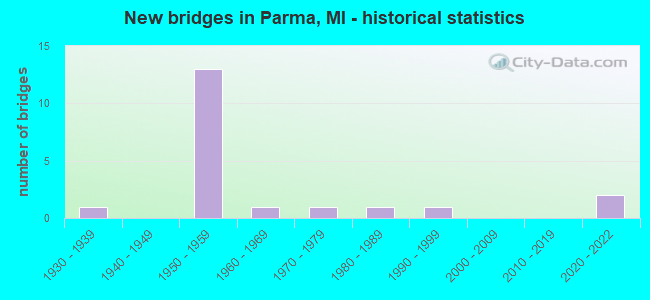
- New bridges - historical statistics
- 11930-1939
- 131950-1959
- 11960-1969
- 11970-1979
- 11980-1989
- 11990-1999
- 22020-2022


- Bridge Condition - Deck
- 8.3%Excellent
- 25.0%Good
- 41.7%Satisfactory
- 25.0%Fair

- Bridge Condition - Superstructure
- 8.3%Excellent
- 8.3%Good
- 25.0%Satisfactory
- 50.0%Fair
- 8.3%Serious

- Bridge Condition - Substructure
- 8.3%Excellent
- 16.7%Very good
- 8.3%Good
- 50.0%Satisfactory
- 8.3%Fair
- 8.3%Serious

- Bridge Condition - Channel
- 16.7%Good
- 33.3%Satisfactory
- 33.3%Fair
- 16.7%Serious
Find on map >> Show street view
Structure Number: 1032, Location: 3 MI E OF NEW BUFFALO (Lat: 41.784725, Lng: -86.668592), Route carried "on" structure: County highway , Year Built: 1961, Year Reconstructed: 2007, Status: Posted for load, Structure Length: 1.55m (5.09ft), Average Daily Traffic: 80 (year 2007), Truck Traffic: 4%, Average Future Daily Traffic: 200 (year 2027), Design Load: HS 15, Features Intersected: S BRANCH GALIEN RIVER, Facility Carried by Structure: LAKESIDE ROAD
Minimum Vertical Clearance: 30.48m (100.00ft), Kilometerpoint: 2.804, Lanes on structure: 2, Owner: County Highway Agency, Approaching Roadway Width: 7.3m (24.0ft), Skew: 2 degrees, Material/Design: Wood or Timber, Design/Construction: Stringer/Multi-beam, Number Of Spans In Main Unit: 1, Length of Maximum Span: 14.9m (48.9ft), Curb-To-Curb Width: 7.3m (24.0ft), Out-to-Out Width: 7.7m (25.3ft)
Condition: Deck: Satisfactory, Superstructure: Satisfactory, Substructure: Serious, Channel: Fair, Operating Rating: 15.9 metric tons, Method Used To Determine Operating Rating: Allowable Stress (AS) rating reported by rating factor (RF) method using MS18 loading, Inventory Rating: 8.1 metric tons, Method Used To Determine Inventory Rating: Allowable Stress (AS) rating reported by rating factor (RF) method using MS18 loading, Structural Evaluation: High priority of corrective action, Deck Geometry: Equal to present minimum criteria, Waterway Adequacy: Equal to present minimum criteria, Approach Roadway Alignment: Equal to present minimum criteria, Bridge Posting: Required (Relationship of Operating Rating to Maximum Legal Load: > 39.9% below), Length Of Structure Improvement: 2.13m (6.99ft), Designated Inspection Frequency: Every 12 months, Inspection Date: April 2021, Bridge Improvement Cost: $250,000, Roadway Improvement Cost: $50,000, Total Project Cost: $300,000, Deck Structure Type: Wood or Timber, Wearing Surface/Protective System: Wearing Surface: Bituminous
Find on map >> Show street view
Structure Number: 2907, Location: 4 1/2 MILES S OF M61 (Lat: 43.924097, Lng: -84.585147), Route carried "on" structure: County highway 2605, Year Built: 1975, Status: Open, Structure Length: 1.09m (3.58ft), Average Daily Traffic: 231 (year 2000), Truck Traffic: 10%, Average Future Daily Traffic: 323 (year 2020), Design Load: HS 20+Mod, Features Intersected: N BR TOBACCO RIVER, Facility Carried by Structure: BARD RD
Minimum Vertical Clearance: 30.48m (100.00ft), Kilometerpoint: 12.095, Lanes on structure: 2, Owner: County Highway Agency, Approaching Roadway Width: 9.8m (32.2ft), Material/Design: Concrete, Design/Construction: Culvert, Number Of Spans In Main Unit: 2, Length of Maximum Span: 4.8m (15.7ft)
Condition: Channel: Fair, Culverts: Fair, Operating Rating: 97.2 metric tons, Method Used To Determine Operating Rating: Load Factor (LF) rating reported by rating factor (RF) method using MS18 loading, Inventory Rating: 74.5 metric tons, Method Used To Determine Inventory Rating: Load Factor (LF) rating reported by rating factor (RF) method using MS18 loading, Structural Evaluation: Somewhat better than minimum adequacy, Waterway Adequacy: Better than present minimum criteria, Approach Roadway Alignment: Better than present minimum criteria, Designated Inspection Frequency: Every 24 months, Inspection Date: March 2020, Deck Structure Type: Concrete Precast Panels, Wearing Surface/Protective System: Wearing Surface: Bituminous, Membrane: Preformed Fabric
Find on map >> Show street view
Structure Number: 4409, Location: 3.0 MI W OF M-60 (Lat: 42.269119, Lng: -84.534536), Route carried "on" structure: Interstate 94, Year Built: 1953, Year Reconstructed: 2007, Status: Open, Structure Length: 3.66m (12.01ft), Average Daily Traffic: 30,500 (year 2007), Truck Traffic: 26%, Average Future Daily Traffic: 50,400 (year 2028), Design Load: HS 25 or greater, Features Intersected: SANDSTONE RIVER
Minimum Vertical Clearance: 30.48m (100.00ft), Kilometerpoint: 15.241, Lanes on structure: 6, Base Highway Network: Yes (Inventory Route: 89, Subroute: 7), Owner: State Highway Agency, Approaching Roadway Width: 39.0m (128.0ft), Skew: 22 degrees, Material/Design: Steel continuous, Design/Construction: Stringer/Multi-beam, Number Of Spans In Main Unit: 3, Length of Maximum Span: 13.4m (44.0ft), Curb-To-Curb Width: 38.0m (124.7ft), Out-to-Out Width: 39.7m (130.2ft)
Condition: Deck: Good, Superstructure: Fair, Substructure: Satisfactory, Channel: Satisfactory, Operating Rating: 97.9 metric tons, Method Used To Determine Operating Rating: Load Factor (LF), Inventory Rating: 58.6 metric tons, Method Used To Determine Inventory Rating: Load Factor (LF), Structural Evaluation: Somewhat better than minimum adequacy, Deck Geometry: Superior to present desirable criteria, Waterway Adequacy: Somewhat better than minimum adequacy, Approach Roadway Alignment: Equal to present desirable criteria, Length Of Structure Improvement: 3.66m (12.01ft), Designated Inspection Frequency: Every 24 months, Inspection Date: May 2021, Bridge Improvement Cost: $412,000, Roadway Improvement Cost: $15,000, Total Project Cost: $177,000, Deck Structure Type: Concrete Cast-file-Place, Wearing Surface/Protective System: Wearing Surface: Monolithic Concrete, Deck Protection: Epoxy Coated Reinforcing
Find on map >> Show street view
Structure Number: 4412, Location: 6.3 MI W OF M-60 (Lat: 42.269197, Lng: -84.599908), Route carried "on" structure: Interstate 94, Year Built: 1954, Status: Open, Structure Length: 4.45m (14.60ft), Average Daily Traffic: 30,873 (year 2014), Truck Traffic: 23%, Average Future Daily Traffic: 35,504 (year 2034), Design Load: HS 20, Features Intersected: PARMA RD
Minimum Vertical Clearance: 30.48m (100.00ft), Kilometerpoint: 9.853, Lanes on structure: 4, Lanes under structure: 2, Base Highway Network: Yes (Inventory Route: 89, Subroute: 7), Owner: State Highway Agency, Approaching Roadway Width: 25.6m (84.0ft), Skew: 30 degrees, Material/Design: Concrete continuous, Design/Construction: Tee Beam, Number Of Spans In Main Unit: 3, Length of Maximum Span: 17.7m (58.1ft), Curb-To-Curb Width: 26.8m (87.9ft), Out-to-Out Width: 30.3m (99.4ft)
Condition: Deck: Satisfactory, Superstructure: Fair, Substructure: Satisfactory, Operating Rating: 59.0 metric tons, Method Used To Determine Operating Rating: Load Factor (LF) rating reported by rating factor (RF) method using MS18 loading, Inventory Rating: 36.6 metric tons, Method Used To Determine Inventory Rating: Load Factor (LF) rating reported by rating factor (RF) method using MS18 loading, Structural Evaluation: Somewhat better than minimum adequacy, Deck Geometry: Superior to present desirable criteria, Underclear: Somewhat better than minimum adequacy, Approach Roadway Alignment: Equal to present desirable criteria, Designated Inspection Frequency: Every 24 months, Inspection Date: June 2021, Deck Structure Type: Concrete Cast-file-Place, Wearing Surface/Protective System: Wearing Surface: Latex Concrete
Find on map >> Show street view
Structure Number: 4413, Location: 3.2 MI W OF M-60 (Lat: 42.269128, Lng: -84.538683), Route carried "on" structure: County highway 3829, Year Built: 1958, Status: Open, Structure Length: 6.52m (21.39ft), Average Daily Traffic: 34,000 (year 1993), Truck Traffic: 1%, Average Future Daily Traffic: 1,160 (year 1977), Design Load: H 15, Features Intersected: I-94, Facility Carried by Structure: DEARING RD
Minimum Vertical Clearance: 30.48m (100.00ft), Kilometerpoint: 6.871, Lanes on structure: 2, Lanes under structure: 4, Owner: State Highway Agency, Approaching Roadway Width: 10.3m (33.8ft), Skew: 2 degrees, Material/Design: Steel, Design/Construction: Stringer/Multi-beam, Number Of Spans In Main Unit: 4, Length of Maximum Span: 16.8m (55.1ft), Curb-To-Curb Width: 8.9m (29.2ft), Out-to-Out Width: 10.2m (33.5ft)
Condition: Deck: Satisfactory, Superstructure: Fair, Substructure: Good, Operating Rating: 73.9 metric tons, Method Used To Determine Operating Rating: Load Factor (LF) rating reported by rating factor (RF) method using MS18 loading, Inventory Rating: 32.7 metric tons, Method Used To Determine Inventory Rating: Load Factor (LF) rating reported by rating factor (RF) method using MS18 loading, Structural Evaluation: Somewhat better than minimum adequacy, Deck Geometry: Meets minimum limits, Underclear: High priority of corrective action, Approach Roadway Alignment: Equal to present desirable criteria, Designated Inspection Frequency: Every 24 months, Inspection Date: May 2021, Deck Structure Type: Concrete Cast-file-Place, Wearing Surface/Protective System: Wearing Surface: Latex Concrete
Find on map >> Show street view
Structure Number: 4414, Location: 2.2 MI W OF M-60 (Lat: 42.268967, Lng: -84.517692), Route carried "on" structure: County highway , Year Built: 1958, Status: Open, Structure Length: 4.88m (16.01ft), Average Daily Traffic: 34,000 (year 1993), Average Future Daily Traffic: 310 (year 1977), Design Load: H 15, Features Intersected: I-94, Facility Carried by Structure: SANDSTONE RD
Minimum Vertical Clearance: 30.48m (100.00ft), Kilometerpoint: 5.839, Lanes on structure: 2, Lanes under structure: 4, Owner: State Highway Agency, Approaching Roadway Width: 10.3m (33.8ft), Material/Design: Steel, Design/Construction: Stringer/Multi-beam, Number Of Spans In Main Unit: 4, Length of Maximum Span: 14.8m (48.6ft), Curb-To-Curb Width: 8.9m (29.2ft), Out-to-Out Width: 10.2m (33.5ft)
Condition: Deck: Fair, Superstructure: Fair, Substructure: Satisfactory, Operating Rating: 49.9 metric tons, Method Used To Determine Operating Rating: Load Factor (LF) rating reported by rating factor (RF) method using MS18 loading, Inventory Rating: 29.8 metric tons, Method Used To Determine Inventory Rating: Load Factor (LF) rating reported by rating factor (RF) method using MS18 loading, Structural Evaluation: Somewhat better than minimum adequacy, Deck Geometry: High priority of replacement, Underclear: High priority of corrective action, Approach Roadway Alignment: Equal to present desirable criteria, Designated Inspection Frequency: Every 24 months, Inspection Date: May 2021, Deck Structure Type: Concrete Cast-file-Place, Wearing Surface/Protective System: Wearing Surface: Monolithic Concrete
Find on map >> Show street view
Structure Number: 4426, Location: 3.1 MI E OF M-99 (Lat: 42.262036, Lng: -84.649125), Route carried "on" structure: Interstate 94, Year Built: 1959, Status: Open, Structure Length: 3.60m (11.81ft), Average Daily Traffic: 29,531 (year 2014), Truck Traffic: 24%, Average Future Daily Traffic: 33,960 (year 2034), Design Load: HS 20, Features Intersected: CONCORD RD
Minimum Vertical Clearance: 30.48m (100.00ft), Kilometerpoint: 5.626, Lanes on structure: 2, Lanes under structure: 2, Base Highway Network: Yes (Inventory Route: 89, Subroute: 7), Owner: State Highway Agency, Approaching Roadway Width: 12.8m (42.0ft), Material/Design: Concrete continuous, Design/Construction: Tee Beam, Number Of Spans In Main Unit: 3, Length of Maximum Span: 14.0m (45.9ft), Curb-To-Curb Width: 13.4m (44.0ft), Out-to-Out Width: 14.6m (47.9ft)
Condition: Deck: Fair, Superstructure: Fair, Substructure: Satisfactory, Operating Rating: 52.2 metric tons, Method Used To Determine Operating Rating: Load Factor (LF) rating reported by rating factor (RF) method using MS18 loading, Inventory Rating: 32.7 metric tons, Method Used To Determine Inventory Rating: Load Factor (LF) rating reported by rating factor (RF) method using MS18 loading, Structural Evaluation: Somewhat better than minimum adequacy, Deck Geometry: Superior to present desirable criteria, Underclear: Equal to present minimum criteria, Approach Roadway Alignment: Equal to present desirable criteria, Designated Inspection Frequency: Every 24 months, Inspection Date: June 2021, Deck Structure Type: Concrete Cast-file-Place, Wearing Surface/Protective System: Wearing Surface: Epoxy Overlay, Deck Protection: Cathodic Protection
Find on map >> Show street view
Structure Number: 4427, Location: 3.1 MI E OF M-99 (Lat: 42.262294, Lng: -84.649133), Route carried "on" structure: Interstate 94, Year Built: 1959, Status: Open, Structure Length: 3.60m (11.81ft), Average Daily Traffic: 29,531 (year 2014), Truck Traffic: 24%, Average Future Daily Traffic: 33,960 (year 2034), Design Load: HS 20, Features Intersected: CONCORD RD
Minimum Vertical Clearance: 30.48m (100.00ft), Kilometerpoint: 5.626, Lanes on structure: 2, Lanes under structure: 2, Base Highway Network: Yes (Inventory Route: 89, Subroute: 9), Owner: State Highway Agency, Approaching Roadway Width: 12.8m (42.0ft), Material/Design: Concrete continuous, Design/Construction: Tee Beam, Number Of Spans In Main Unit: 3, Length of Maximum Span: 14.0m (45.9ft), Curb-To-Curb Width: 13.4m (44.0ft), Out-to-Out Width: 14.6m (47.9ft)
Condition: Deck: Satisfactory, Superstructure: Satisfactory, Substructure: Satisfactory, Operating Rating: 53.1 metric tons, Method Used To Determine Operating Rating: Load Factor (LF) rating reported by rating factor (RF) method using MS18 loading, Inventory Rating: 32.7 metric tons, Method Used To Determine Inventory Rating: Load Factor (LF) rating reported by rating factor (RF) method using MS18 loading, Structural Evaluation: Equal to present minimum criteria, Deck Geometry: Superior to present desirable criteria, Underclear: Equal to present minimum criteria, Approach Roadway Alignment: Equal to present desirable criteria, Designated Inspection Frequency: Every 24 months, Inspection Date: June 2021, Deck Structure Type: Concrete Cast-file-Place, Wearing Surface/Protective System: Wearing Surface: Epoxy Overlay, Deck Protection: Cathodic Protection
Find on map >> Show street view
Structure Number: 4428, Location: 4.3 MI E OF M-99 (Lat: 42.265928, Lng: -84.620119), Route carried "on" structure: County highway 3852, Year Built: 1959, Status: Open, Structure Length: 6.44m (21.13ft), Average Daily Traffic: 25,000 (year 1993), Average Future Daily Traffic: 28,750 (year 2013), Design Load: H 20, Features Intersected: I-94, Facility Carried by Structure: MICHIGAN AVE
Minimum Vertical Clearance: 30.48m (100.00ft), Kilometerpoint: 7.505, Lanes on structure: 2, Lanes under structure: 4, Owner: State Highway Agency, Approaching Roadway Width: 12.2m (40.0ft), Skew: 3 degrees, Material/Design: Concrete continuous, Design/Construction: Tee Beam, Number Of Spans In Main Unit: 4, Length of Maximum Span: 19.8m (65.0ft), Curb-To-Curb Width: 9.1m (29.9ft), Out-to-Out Width: 10.2m (33.5ft)
Condition: Deck: Satisfactory, Superstructure: Fair, Substructure: Satisfactory, Operating Rating: 55.7 metric tons, Method Used To Determine Operating Rating: Load Factor (LF) rating reported by rating factor (RF) method using MS18 loading, Inventory Rating: 33.4 metric tons, Method Used To Determine Inventory Rating: Load Factor (LF) rating reported by rating factor (RF) method using MS18 loading, Structural Evaluation: Somewhat better than minimum adequacy, Deck Geometry: Meets minimum limits, Underclear: High priority of corrective action, Approach Roadway Alignment: Equal to present desirable criteria, Designated Inspection Frequency: Every 24 months, Inspection Date: June 2021, Deck Structure Type: Concrete Cast-file-Place, Wearing Surface/Protective System: Wearing Surface: Epoxy Overlay, Deck Protection: Cathodic Protection
Find on map >> Show street view
Structure Number: 4476, Location: WEST CITY LIMITS OF PARMA (Lat: 42.259181, Lng: -84.602597), Route carried "on" structure: County highway 3852, Year Built: 2020, Status: Open, Structure Length: 7.41m (24.31ft), Average Daily Traffic: 3,659 (year 2019), Truck Traffic: 2%, Average Future Daily Traffic: 5,437 (year 2039), Design Load: Greater than HL93, Features Intersected: MDOT RR COR & RR STREET, Facility Carried by Structure: MICHIGAN AVENUE
Minimum Vertical Clearance: 30.48m (100.00ft), Kilometerpoint: 9.133, Lanes on structure: 2, Lanes under structure: 2, Owner: County Highway Agency, Approaching Roadway Width: 8.9m (29.2ft), Skew: 2 degrees, Material/Design: Prestressed concrete, Design/Construction: Box Beam or Girders - Multiple, Number Of Spans In Main Unit: 3, Length of Maximum Span: 27.4m (89.9ft), Curb or Sidewalk Widths: Left: 1.6m (5.2ft), Right: 1.6m (5.2ft), Curb-To-Curb Width: 8.5m (27.9ft), Out-to-Out Width: 12.3m (40.4ft)
Condition: Deck: Excellent, Superstructure: Excellent, Substructure: Excellent, Operating Rating: 75.5 metric tons, Method Used To Determine Operating Rating: Load and Resistance Factor Rating (LRFR) rating reported by rating factor(RF) method using HL-93 loadings, Inventory Rating: 58.3 metric tons, Method Used To Determine Inventory Rating: Load and Resistance Factor Rating (LRFR) rating reported by rating factor(RF) method using HL-93 loadings, Structural Evaluation: Superior to present desirable criteria, Deck Geometry: Meets minimum limits, Underclear: High priority of replacement, Approach Roadway Alignment: Equal to present minimum criteria, Length Of Structure Improvement: 6.10m (20.01ft), Designated Inspection Frequency: Every 24 months, Inspection Date: November 2020, Bridge Improvement Cost: $500,000,000, Roadway Improvement Cost: $100,000,000, Total Project Cost: $600,000,000, Deck Structure Type: Concrete Cast-file-Place, Wearing Surface/Protective System: Wearing Surface: Monolithic Concrete, Deck Protection: Epoxy Coated Reinforcing
Find on map >> Show street view
Structure Number: 4477, Location: 5 MI E OF PARMA (Lat: 42.253517, Lng: -84.504083), Route carried "on" structure: County highway 3852, Year Built: 1996, Status: Open, Structure Length: 1.03m (3.38ft), Average Daily Traffic: 6,600 (year 2002), Truck Traffic: 5%, Average Future Daily Traffic: 9,500 (year 2022), Design Load: HS 25 or greater, Features Intersected: SANDSTONE CREEK, Facility Carried by Structure: MICHIGAN AVE
Minimum Vertical Clearance: 30.48m (100.00ft), Kilometerpoint: 17.402, Lanes on structure: 2, Owner: County Highway Agency, Approaching Roadway Width: 12.5m (41.0ft), Material/Design: Prestressed concrete, Design/Construction: Box Beam or Girders - Multiple, Number Of Spans In Main Unit: 1, Length of Maximum Span: 10.0m (32.8ft), Curb-To-Curb Width: 12.5m (41.0ft), Out-to-Out Width: 13.3m (43.6ft)
Condition: Deck: Good, Superstructure: Satisfactory, Substructure: Very good, Channel: Good, Inventory Rating: 64.3 metric tons, Method Used To Determine Inventory Rating: Load Factor (LF), Structural Evaluation: Equal to present minimum criteria, Deck Geometry: Somewhat better than minimum adequacy, Waterway Adequacy: Equal to present minimum criteria, Approach Roadway Alignment: Equal to present desirable criteria, Designated Inspection Frequency: Every 24 months, Inspection Date: June 2021, Deck Structure Type: Concrete Cast-file-Place, Wearing Surface/Protective System: Wearing Surface: Monolithic Concrete, Deck Protection: Epoxy Coated Reinforcing
Find on map >> Show street view
Structure Number: 4479, Location: 1.6 MI E 2.0 MI N PARMA (Lat: 42.295786, Lng: -84.560217), Route carried "on" structure: County highway , Year Built: 1939, Status: Posted for load, Structure Length: 1.49m (4.89ft), Average Daily Traffic: 396 (year 2018), Average Future Daily Traffic: 594 (year 2038), Features Intersected: SANDSTONE CREEK, Facility Carried by Structure: BENN ROAD
Minimum Vertical Clearance: 30.48m (100.00ft), Kilometerpoint: 2.195, Lanes on structure: 2, Owner: County Highway Agency, Approaching Roadway Width: 8.2m (26.9ft), Material/Design: Steel, Design/Construction: Stringer/Multi-beam, Number Of Spans In Main Unit: 1, Length of Maximum Span: 14.3m (46.9ft), Curb-To-Curb Width: 8.2m (26.9ft), Out-to-Out Width: 8.9m (29.2ft)
Condition: Deck: Fair, Superstructure: Serious, Substructure: Fair, Channel: Serious, Operating Rating: 7.5 metric tons, Method Used To Determine Operating Rating: Load Factor (LF) rating reported by rating factor (RF) method using MS18 loading, Inventory Rating: 4.5 metric tons, Method Used To Determine Inventory Rating: Load Factor (LF) rating reported by rating factor (RF) method using MS18 loading, Structural Evaluation: High priority of replacement, Deck Geometry: Somewhat better than minimum adequacy, Waterway Adequacy: Meets minimum limits, Approach Roadway Alignment: Meets minimum limits, Bridge Posting: Required (Relationship of Operating Rating to Maximum Legal Load: > 39.9% below), Length Of Structure Improvement: 6.00m (19.69ft), Designated Inspection Frequency: Every 6 months, Inspection Date: October 2021, Bridge Improvement Cost: $500,000, Roadway Improvement Cost: $150,000, Total Project Cost: $650,000 ( Estimate for 2014), Deck Structure Type: Concrete Cast-file-Place, Wearing Surface/Protective System: Wearing Surface: Bituminous
Find on map >> Show street view
Structure Number: 4492, Location: 2 MI N OF INTERSTATE 94 (Lat: 42.296592, Lng: -84.537197), Route carried "on" structure: County highway 3829, Year Built: 1985, Status: Open, Structure Length: 2.04m (6.69ft), Average Daily Traffic: 1,237 (year 2005), Average Future Daily Traffic: 1,700 (year 2015), Design Load: HS 20+Mod, Features Intersected: SANDSTONE CREEK, Facility Carried by Structure: DEARING ROAD
Minimum Vertical Clearance: 30.48m (100.00ft), Kilometerpoint: 9.954, Lanes on structure: 2, Owner: County Highway Agency, Approaching Roadway Width: 8.5m (27.9ft), Skew: 2 degrees, Material/Design: Prestressed concrete, Design/Construction: Box Beam or Girders - Multiple, Number Of Spans In Main Unit: 1, Length of Maximum Span: 20.4m (66.9ft), Curb-To-Curb Width: 10.4m (34.1ft), Out-to-Out Width: 11.4m (37.4ft)
Condition: Deck: Good, Superstructure: Good, Substructure: Very good, Channel: Satisfactory, Operating Rating: 70.8 metric tons, Method Used To Determine Operating Rating: Load Factor (LF), Inventory Rating: 42.4 metric tons, Method Used To Determine Inventory Rating: Load Factor (LF), Structural Evaluation: Better than present minimum criteria, Deck Geometry: Equal to present minimum criteria, Waterway Adequacy: Equal to present desirable criteria, Approach Roadway Alignment: Equal to present desirable criteria, Designated Inspection Frequency: Every 24 months, Inspection Date: June 2021, Deck Structure Type: Concrete Cast-file-Place, Wearing Surface/Protective System: Wearing Surface: Bituminous, Membrane: Preformed Fabric, Deck Protection: Epoxy Coated Reinforcing
Find on map >> Show street view
Structure Number: 4412, Location: 6.3 MI W OF M-60 (Lat: 42.269197, Lng: -84.599908), Route carried "under" structure: County highway 3819, Year Built: 1954, Structure Length: 0. m, Average Daily Traffic: 2,500 (year 1974), Features Intersected: PARMA RD, Facility Carried by Structure: I-94
Minimum Vertical Clearance: 4.44m (14.57ft), Kilometerpoint: 5.628, Lanes on structure: 4, Lanes under structure: 2, Material/Design: Concrete continuous, Design/Construction: Tee Beam, Length of Maximum Span: 17.7m (58.1ft)
Find on map >> Show street view
Structure Number: 4413, Location: 3.2 MI W OF M-60 (Lat: 42.269128, Lng: -84.538683), Route carried "under" structure: Interstate 94, Year Built: 1958, Structure Length: 0. m, Average Daily Traffic: 31,459 (year 2014), Truck Traffic: 23%, Features Intersected: I-94, Facility Carried by Structure: DEARING RD
Minimum Vertical Clearance: 4.52m (14.83ft), Kilometerpoint: 14.898, Lanes on structure: 2, Lanes under structure: 4, Material/Design: Steel, Design/Construction: Stringer/Multi-beam, Length of Maximum Span: 16.8m (55.1ft)
Find on map >> Show street view
Structure Number: 4414, Location: 2.2 MI W OF M-60 (Lat: 42.268967, Lng: -84.517692), Route carried "under" structure: Interstate 94, Year Built: 1958, Structure Length: 0. m, Average Daily Traffic: 34,202 (year 2014), Truck Traffic: 21%, Features Intersected: I-94, Facility Carried by Structure: SANDSTONE RD
Minimum Vertical Clearance: 4.39m (14.40ft), Kilometerpoint: 16.635, Lanes on structure: 2, Lanes under structure: 4, Material/Design: Steel, Design/Construction: Stringer/Multi-beam, Length of Maximum Span: 14.8m (48.6ft)
Find on map >> Show street view
Structure Number: 4426, Location: 3.1 MI E OF M-99 (Lat: 42.262036, Lng: -84.649125), Route carried "under" structure: County highway , Year Built: 1959, Structure Length: 0. m, Average Daily Traffic: 350 (year 1995), Features Intersected: CONCORD RD, Facility Carried by Structure: I-94 EB
Minimum Vertical Clearance: 4.82m (15.81ft), Kilometerpoint: 3.304, Lanes on structure: 2, Lanes under structure: 2, Material/Design: Concrete continuous, Design/Construction: Tee Beam, Length of Maximum Span: 14.0m (45.9ft)
Find on map >> Show street view
Structure Number: 4427, Location: 3.1 MI E OF M-99 (Lat: 42.262294, Lng: -84.649133), Route carried "under" structure: County highway , Year Built: 1959, Structure Length: 0. m, Average Daily Traffic: 350 (year 1995), Features Intersected: CONCORD RD, Facility Carried by Structure: I-94 WB
Minimum Vertical Clearance: 4.62m (15.16ft), Kilometerpoint: 3.331, Lanes on structure: 2, Lanes under structure: 2, Material/Design: Concrete continuous, Design/Construction: Tee Beam, Length of Maximum Span: 14.0m (45.9ft)
Find on map >> Show street view
Structure Number: 4428, Location: 4.3 MI E OF M-99 (Lat: 42.265928, Lng: -84.620119), Route carried "under" structure: Interstate 94, Year Built: 1959, Structure Length: 0. m, Average Daily Traffic: 30,873 (year 2014), Truck Traffic: 23%, Features Intersected: I-94, Facility Carried by Structure: MICHIGAN AVE
Minimum Vertical Clearance: 4.82m (15.81ft), Kilometerpoint: 8.113, Lanes on structure: 2, Lanes under structure: 4, Material/Design: Concrete continuous, Design/Construction: Tee Beam, Length of Maximum Span: 19.8m (65.0ft)
Find on map >> Show street view
Structure Number: 4476, Location: WEST CITY LIMITS OF PARMA (Lat: 42.259181, Lng: -84.602597), Route carried "under" structure: City street , Year Built: 2020, Structure Length: 0. m, Average Daily Traffic: 75 (year 1980), Features Intersected: MDOT RR COR & RR STREET, Facility Carried by Structure: MICHIGAN AVENUE
Minimum Vertical Clearance: 5.23m (17.16ft), Kilometerpoint: 11.811, Lanes on structure: 2, Lanes under structure: 2, Material/Design: Prestressed concrete, Design/Construction: Box Beam or Girders - Multiple, Length of Maximum Span: 27.4m (89.9ft)