Bridge Statistics for Parkwood, California (CA)
Condition, Traffic, Stress, Structural Evaluation, Project Costs
- National Bridge Inventory (NBI) Statistics
- 11Number of bridges
- 256ft / 78.3mTotal length
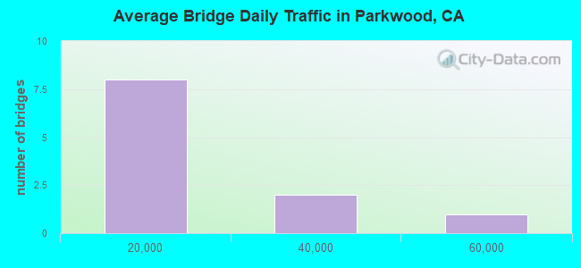
- 138,301Total average daily traffic
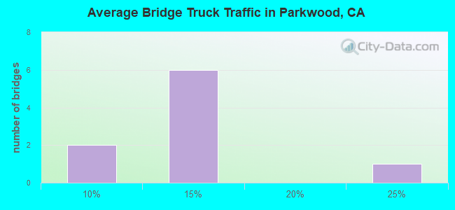
- 15,172Total average daily truck traffic
- National Bridge Inventory (NBI) Registered Bridges for Parkwood
- No street view available for this location
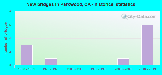
- New bridges - historical statistics
- 31960-1969
- 11970-1979
- 12000-2009
- 62010-2019
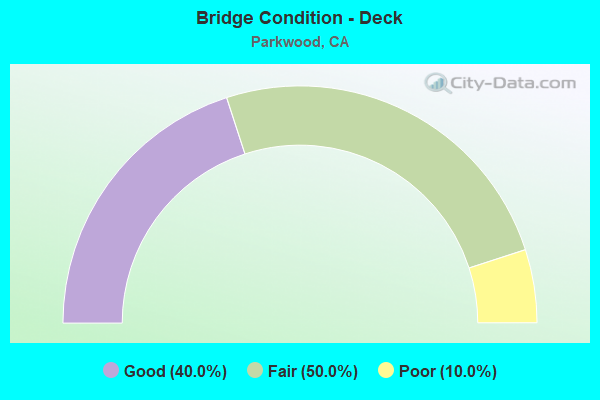
- Bridge Condition - Deck
- 40.0%Good
- 50.0%Fair
- 10.0%Poor
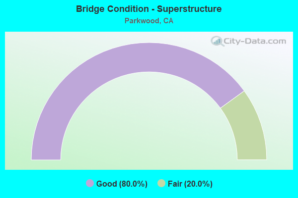
- Bridge Condition - Superstructure
- 80.0%Good
- 20.0%Fair
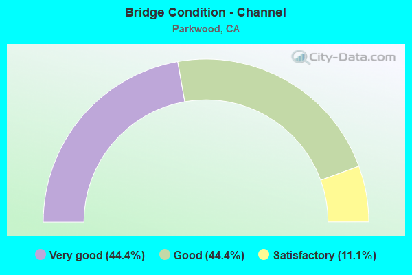
- Bridge Condition - Channel
- 44.4%Very good
- 44.4%Good
- 11.1%Satisfactory
Find on map >> Show street view
Structure Number: 41 0065L, Location: 06-MAD-099-R7.28 (Lat: 36.921731, Lng: -120.019617), Route carried "on" structure: State highway 99, Year Built: 1967, Status: Open, Structure Length: 7.32m (24.02ft), Average Daily Traffic: 32,500 (year 2009), Average Future Daily Traffic: 69,522 (year 2043), Design Load: HS 20, Features Intersected: COTTONWOOD CREEK
Minimum Vertical Clearance: 30+ m (98+ ft), Kilometerpoint: 7.280, Lanes on structure: 2, Base Highway Network: Yes (, Subroute: 1), Owner: State Highway Agency, Approaching Roadway Width: 11.9m (39.0ft), Skew: 3 degrees, Material/Design: Concrete continuous, Design/Construction: Tee Beam, Number Of Spans In Main Unit: 8, Length of Maximum Span: 10.1m (33.1ft), Curb-To-Curb Width: 11.5m (37.7ft), Out-to-Out Width: 12.1m (39.7ft)
Condition: Deck: Poor, Superstructure: Good, Substructure: Good, Channel: Good, Operating Rating: 39.2 metric tons, Method Used To Determine Operating Rating: Load and Resistance Factor Rating (LRFR) rating reported by rating factor(RF) method using HL-93 loadings, Inventory Rating: 27.9 metric tons, Method Used To Determine Inventory Rating: Load and Resistance Factor Rating (LRFR) rating reported by rating factor(RF) method using HL-93 loadings, Structural Evaluation: Better than present minimum criteria, Deck Geometry: Equal to present minimum criteria, Waterway Adequacy: Equal to present desirable criteria, Approach Roadway Alignment: Equal to present desirable criteria, Designated Inspection Frequency: Every 24 months, Inspection Date: June 2021, Deck Structure Type: Concrete Cast-file-Place, Wearing Surface/Protective System: Wearing Surface: Bituminous
Find on map >> Show street view
Structure Number: 41 0065R, Location: 06-MAD-099-R7.28 (Lat: 36.921958, Lng: -120.019569), Route carried "on" structure: State highway 99, Year Built: 1967, Status: Open, Structure Length: 7.32m (24.02ft), Average Daily Traffic: 32,500 (year 2009), Average Future Daily Traffic: 69,522 (year 2043), Design Load: HS 20, Features Intersected: COTTONWOOD CREEK
Minimum Vertical Clearance: 30+ m (98+ ft), Kilometerpoint: 7.280, Lanes on structure: 2, Base Highway Network: Yes (, Subroute: 1), Owner: State Highway Agency, Approaching Roadway Width: 11.9m (39.0ft), Skew: 3 degrees, Material/Design: Concrete continuous, Design/Construction: Tee Beam, Number Of Spans In Main Unit: 8, Length of Maximum Span: 10.1m (33.1ft), Curb-To-Curb Width: 11.5m (37.7ft), Out-to-Out Width: 12.1m (39.7ft)
Condition: Deck: Fair, Superstructure: Good, Substructure: Good, Channel: Good, Operating Rating: 39.2 metric tons, Method Used To Determine Operating Rating: Load and Resistance Factor Rating (LRFR) rating reported by rating factor(RF) method using HL-93 loadings, Inventory Rating: 27.9 metric tons, Method Used To Determine Inventory Rating: Load and Resistance Factor Rating (LRFR) rating reported by rating factor(RF) method using HL-93 loadings, Structural Evaluation: Better than present minimum criteria, Deck Geometry: Equal to present minimum criteria, Waterway Adequacy: Better than present minimum criteria, Approach Roadway Alignment: Equal to present desirable criteria, Designated Inspection Frequency: Every 24 months, Inspection Date: June 2021, Deck Structure Type: Concrete Cast-file-Place
Find on map >> Show street view
Structure Number: 41 0065S, Location: 06-MAD-099-R7.28 (Lat: 36.922133, Lng: -120.019569), Route carried "on" structure: Ramp State highway 99, Year Built: 1967, Status: Open, Structure Length: 8.26m (27.10ft), Average Daily Traffic: 1,650 (year 2010), Truck Traffic: 10%, Average Future Daily Traffic: 3,446 (year 2041), Design Load: HS 20, Features Intersected: COTTONWOOD CREEK
Minimum Vertical Clearance: 30+ m (98+ ft), Kilometerpoint: 7.280, Lanes on structure: 1, Owner: State Highway Agency, Approaching Roadway Width: 6.8m (22.3ft), Skew: 4 degrees, Material/Design: Concrete continuous, Design/Construction: Tee Beam, Number Of Spans In Main Unit: 8, Length of Maximum Span: 11.0m (36.1ft), Curb or Sidewalk Widths: Left: 0.6m (2.0ft), Right: 0.0m, Curb-To-Curb Width: 6.8m (22.3ft), Out-to-Out Width: 8.0m (26.2ft)
Condition: Deck: Fair, Superstructure: Good, Substructure: Good, Channel: Good, Operating Rating: 39.2 metric tons, Method Used To Determine Operating Rating: Load and Resistance Factor Rating (LRFR) rating reported by rating factor(RF) method using HL-93 loadings, Inventory Rating: 27.5 metric tons, Method Used To Determine Inventory Rating: Load and Resistance Factor Rating (LRFR) rating reported by rating factor(RF) method using HL-93 loadings, Structural Evaluation: Equal to present minimum criteria, Deck Geometry: Equal to present minimum criteria, Waterway Adequacy: Equal to present desirable criteria, Approach Roadway Alignment: Equal to present minimum criteria, Designated Inspection Frequency: Every 24 months, Inspection Date: June 2021, Deck Structure Type: Concrete Cast-file-Place
Find on map >> Show street view
Structure Number: 41 0087, Location: 06-MAD-145-5.39 (Lat: 36.899758, Lng: -120.055122), Route carried "on" structure: State highway 145, Year Built: 2009, Status: Open, Structure Length: 4.09m (13.42ft), Average Daily Traffic: 5,800 (year 2009), Truck Traffic: 12%, Average Future Daily Traffic: 13,053 (year 2041), Design Load: HL 93, Features Intersected: COTTONWOOD CREEK
Minimum Vertical Clearance: 30+ m (98+ ft), Kilometerpoint: 5.390, Lanes on structure: 2, Base Highway Network: Yes (Inventory Route: 1, Subroute: 1), Owner: State Highway Agency, Approaching Roadway Width: 12.0m (39.4ft), Skew: 2 degrees, Material/Design: Concrete continuous, Design/Construction: Slab, Number Of Spans In Main Unit: 5, Length of Maximum Span: 9.2m (30.2ft), Curb-To-Curb Width: 12.0m (39.4ft), Out-to-Out Width: 12.9m (42.3ft)
Condition: Deck: Fair, Superstructure: Fair, Substructure: Good, Channel: Very good, Operating Rating: 42.1 metric tons, Method Used To Determine Operating Rating: Assigned ratings based on Load and Resistance Factor Design (LRFD) reported by rating factor (RF) using HL93 loadings, Inventory Rating: 32.4 metric tons, Method Used To Determine Inventory Rating: Assigned ratings based on Load and Resistance Factor Design (LRFD) reported by rating factor (RF) using HL93 loadings, Structural Evaluation: Somewhat better than minimum adequacy, Deck Geometry: Somewhat better than minimum adequacy, Waterway Adequacy: Equal to present minimum criteria, Approach Roadway Alignment: Equal to present desirable criteria, Designated Inspection Frequency: Every 24 months, Inspection Date: November 2020, Deck Structure Type: Concrete Cast-file-Place
Find on map >> Show street view
Structure Number: 41 0088, Location: 06-MAD-099-R7.10 (Lat: 36.924100, Lng: -120.022283), Route carried "on" structure: County highway , Year Built: 2016, Status: Open, Structure Length: 9.02m (29.59ft), Average Daily Traffic: 5,000 (year 2016), Truck Traffic: 8%, Average Future Daily Traffic: 6,141 (year 2041), Design Load: HL 93, Features Intersected: SR 99, Facility Carried by Structure: AVENUE 12
Minimum Vertical Clearance: 30+ m (98+ ft), Kilometerpoint: 0.000, Lanes on structure: 8, Lanes under structure: 4, Owner: State Highway Agency, Approaching Roadway Width: 39.0m (128.0ft), Skew: 3 degrees, Material/Design: Prestressed concrete continuous, Design/Construction: Box Beam or Girders - Multiple, Number Of Spans In Main Unit: 2, Length of Maximum Span: 45.1m (148.0ft), Curb or Sidewalk Widths: Left: 3.0m (9.8ft), Right: 3.0m (9.8ft), Curb-To-Curb Width: 39.0m (128.0ft), Out-to-Out Width: 45.7m (149.9ft)
Condition: Deck: Fair, Superstructure: Good, Substructure: Good, Operating Rating: 42.1 metric tons, Method Used To Determine Operating Rating: Assigned ratings based on Load and Resistance Factor Design (LRFD) reported by rating factor (RF) using HL93 loadings, Inventory Rating: 32.4 metric tons, Method Used To Determine Inventory Rating: Assigned ratings based on Load and Resistance Factor Design (LRFD) reported by rating factor (RF) using HL93 loadings, Structural Evaluation: Better than present minimum criteria, Deck Geometry: Superior to present desirable criteria, Underclear: Equal to present minimum criteria, Approach Roadway Alignment: Equal to present desirable criteria, Designated Inspection Frequency: Every 24 months, Inspection Date: June 2021, Deck Structure Type: Concrete Cast-file-Place
Find on map >> Show street view
Structure Number: 41 0089K, Location: 06-MAD-099-R7.28 (Lat: 36.922128, Lng: -120.020461), Route carried "on" structure: Ramp State highway 99, Year Built: 2016, Status: Open, Structure Length: 6.89m (22.60ft), Average Daily Traffic: 1,650 (year 2010), Truck Traffic: 10%, Average Future Daily Traffic: 3,563 (year 2043), Design Load: HL 93, Features Intersected: SR 99, Facility Carried by Structure: ONRAMP
Minimum Vertical Clearance: 30+ m (98+ ft), Kilometerpoint: 7.280, Lanes on structure: 1, Owner: State Highway Agency, Approaching Roadway Width: 7.3m (24.0ft), Skew: 3 degrees, Material/Design: Prestressed concrete continuous, Design/Construction: Slab, Number Of Spans In Main Unit: 4, Length of Maximum Span: 19.7m (64.6ft), Curb-To-Curb Width: 7.3m (24.0ft), Out-to-Out Width: 8.2m (26.9ft)
Condition: Deck: Good, Superstructure: Good, Substructure: Good, Channel: Very good, Operating Rating: 42.1 metric tons, Method Used To Determine Operating Rating: Assigned ratings based on Load and Resistance Factor Design (LRFD) reported by rating factor (RF) using HL93 loadings, Inventory Rating: 32.4 metric tons, Method Used To Determine Inventory Rating: Assigned ratings based on Load and Resistance Factor Design (LRFD) reported by rating factor (RF) using HL93 loadings, Structural Evaluation: Better than present minimum criteria, Deck Geometry: Better than present minimum criteria, Waterway Adequacy: Equal to present desirable criteria, Approach Roadway Alignment: Equal to present desirable criteria, Designated Inspection Frequency: Every 48 months, Inspection Date: June 2021, Deck Structure Type: Concrete Cast-file-Place
Find on map >> Show street view
Structure Number: 41C0024, Location: 0.07 MI W RD 28 1/2 (Lat: 36.909350, Lng: -120.030306), Route carried "on" structure: County highway , Year Built: 1977, Status: Open, Structure Length: 3.54m (11.61ft), Average Daily Traffic: 425 (year 1979), Truck Traffic: 7%, Average Future Daily Traffic: 1,095 (year 2042), Design Load: HS 20, Features Intersected: COTTONWOOD CREEK, Facility Carried by Structure: AVE 11
Minimum Vertical Clearance: 30+ m (98+ ft), Kilometerpoint: 0.000, Lanes on structure: 2, Owner: County Highway Agency, Approaching Roadway Width: 6.1m (20.0ft), Skew: 4 degrees, Material/Design: Concrete continuous, Design/Construction: Slab, Number Of Spans In Main Unit: 4, Length of Maximum Span: 8.5m (27.9ft), Curb-To-Curb Width: 9.2m (30.2ft), Out-to-Out Width: 9.4m (30.8ft)
Condition: Deck: Fair, Superstructure: Fair, Substructure: Good, Channel: Good, Operating Rating: 40.5 metric tons, Method Used To Determine Operating Rating: Load and Resistance Factor Rating (LRFR) rating reported by rating factor(RF) method using HL-93 loadings, Inventory Rating: 31.1 metric tons, Method Used To Determine Inventory Rating: Load and Resistance Factor Rating (LRFR) rating reported by rating factor(RF) method using HL-93 loadings, Structural Evaluation: Somewhat better than minimum adequacy, Deck Geometry: Equal to present minimum criteria, Waterway Adequacy: Equal to present desirable criteria, Approach Roadway Alignment: Equal to present desirable criteria, Designated Inspection Frequency: Every 24 months, Inspection Date: Febuary 2022, Deck Structure Type: Concrete Cast-file-Place
Find on map >> Show street view
Structure Number: 41C0203, Location: 0.6MI N OF AVE 10 (Lat: 36.901831, Lng: -120.037497), Route carried "on" structure: County highway , Year Built: 2011, Status: Open, Structure Length: 6.14m (20.14ft), Average Daily Traffic: 161 (year 1978), Truck Traffic: 10%, Average Future Daily Traffic: 339 (year 2044), Features Intersected: COTTONWOOD CREEK, Facility Carried by Structure: ROAD 28
Minimum Vertical Clearance: 30+ m (98+ ft), Kilometerpoint: 0.000, Lanes on structure: 2, Owner: County Highway Agency, Approaching Roadway Width: 9.8m (32.2ft), Skew: 2 degrees, Material/Design: Concrete continuous, Design/Construction: Slab, Number Of Spans In Main Unit: 7, Length of Maximum Span: 9.3m (30.5ft), Curb-To-Curb Width: 9.8m (32.2ft), Out-to-Out Width: 10.8m (35.4ft)
Condition: Deck: Good, Superstructure: Good, Substructure: Good, Channel: Satisfactory, Operating Rating: 54.1 metric tons, Method Used To Determine Operating Rating: Field evaluation and documented engineering judgment, Inventory Rating: 32.4 metric tons, Method Used To Determine Inventory Rating: Field evaluation and documented engineering judgment, Structural Evaluation: Better than present minimum criteria, Deck Geometry: Better than present minimum criteria, Waterway Adequacy: Equal to present minimum criteria, Approach Roadway Alignment: Equal to present desirable criteria, Designated Inspection Frequency: Every 48 months, Inspection Date: Febuary 2022, Deck Structure Type: Concrete Cast-file-Place
Find on map >> Show street view
Structure Number: 41C0207, Location: 0.04 MI E/O SR 99 (Lat: 36.923953, Lng: -120.021019), Route carried "on" structure: County highway , Year Built: 2015, Status: Open, Structure Length: 19.29m (63.29ft), Average Daily Traffic: 2,000 (year 2000), Truck Traffic: 10%, Average Future Daily Traffic: 4,956 (year 2042), Design Load: Greater than HL93, Features Intersected: UP RR, COTTONWOOD CREEK, Facility Carried by Structure: AVENUE 12
Minimum Vertical Clearance: 30+ m (98+ ft), Kilometerpoint: 0.000, Lanes on structure: 7, Owner: County Highway Agency, Approaching Roadway Width: 18.3m (60.0ft), Skew: 34 degrees, Material/Design: Prestressed concrete continuous, Design/Construction: Box Beam or Girders - Multiple, Number Of Spans In Main Unit: 3, Length of Maximum Span: 65.5m (214.9ft), Curb or Sidewalk Widths: Left: 3.0m (9.8ft), Right: 3.0m (9.8ft), Curb-To-Curb Width: 32.9m (107.9ft), Out-to-Out Width: 45.7m (149.9ft)
Condition: Deck: Good, Superstructure: Good, Substructure: Good, Channel: Very good, Operating Rating: 42.1 metric tons, Method Used To Determine Operating Rating: Assigned ratings based on Load and Resistance Factor Design (LRFD) reported by rating factor (RF) using HL93 loadings, Inventory Rating: 32.4 metric tons, Method Used To Determine Inventory Rating: Assigned ratings based on Load and Resistance Factor Design (LRFD) reported by rating factor (RF) using HL93 loadings, Structural Evaluation: Better than present minimum criteria, Deck Geometry: Superior to present desirable criteria, Underclear: Superior to present desirable criteria, Waterway Adequacy: Equal to present minimum criteria, Approach Roadway Alignment: Equal to present desirable criteria, Designated Inspection Frequency: Every 24 months, Inspection Date: Febuary 2022, Deck Structure Type: Concrete Cast-file-Place
Find on map >> Show street view
Structure Number: 41C0209, Location: 0.27 MI S/O AVE 12 (Lat: 36.922306, Lng: -120.021300), Route carried "on" structure: County highway , Year Built: 2015, Status: Open, Structure Length: 6.46m (21.19ft), Average Daily Traffic: 615 (year 2016), Truck Traffic: 10%, Average Future Daily Traffic: 738 (year 2044), Design Load: Greater than HL93, Features Intersected: COTTONWOOD CREEK, Facility Carried by Structure: ROAD 29
Minimum Vertical Clearance: 30+ m (98+ ft), Kilometerpoint: 0.000, Lanes on structure: 2, Owner: County Highway Agency, Approaching Roadway Width: 9.8m (32.2ft), Material/Design: Prestressed concrete continuous, Design/Construction: Slab, Number Of Spans In Main Unit: 3, Length of Maximum Span: 23.0m (75.5ft), Curb-To-Curb Width: 9.8m (32.2ft), Out-to-Out Width: 10.6m (34.8ft)
Condition: Deck: Good, Superstructure: Good, Substructure: Good, Channel: Very good, Operating Rating: 42.1 metric tons, Method Used To Determine Operating Rating: Assigned ratings based on Load and Resistance Factor Design (LRFD) reported by rating factor (RF) using HL93 loadings, Inventory Rating: 32.4 metric tons, Method Used To Determine Inventory Rating: Assigned ratings based on Load and Resistance Factor Design (LRFD) reported by rating factor (RF) using HL93 loadings, Structural Evaluation: Better than present minimum criteria, Deck Geometry: Equal to present minimum criteria, Waterway Adequacy: Equal to present desirable criteria, Approach Roadway Alignment: Equal to present desirable criteria, Designated Inspection Frequency: Every 48 months, Inspection Date: Febuary 2022, Deck Structure Type: Concrete Cast-file-Place
Find on map >> Show street view
Structure Number: 41 0088, Location: 06-MAD-099-R7.10 (Lat: 36.924100, Lng: -120.022283), Route carried "under" structure: State highway 99, Year Built: 2016, Structure Length: 0. m, Average Daily Traffic: 56,000 (year 2009), Truck Traffic: 24%, Features Intersected: SR 99, Facility Carried by Structure: AVENUE 12
Minimum Vertical Clearance: 5.30m (17.39ft), Kilometerpoint: 7.100, Lanes on structure: 8, Lanes under structure: 4, Material/Design: Prestressed concrete continuous, Design/Construction: Box Beam or Girders - Multiple, Length of Maximum Span: 45.1m (148.0ft)