Bridge Statistics for Parkland, Florida (FL)
Condition, Traffic, Stress, Structural Evaluation, Project Costs
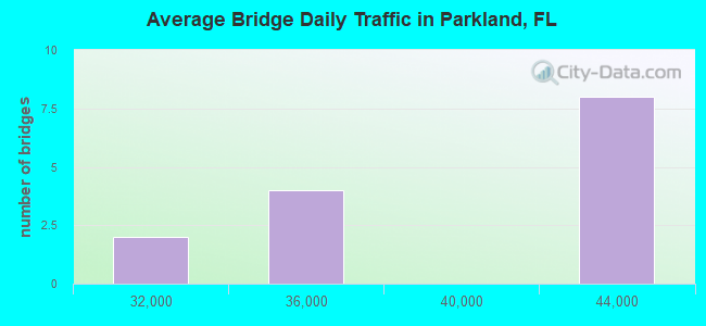
- National Bridge Inventory (NBI) Statistics
- 14Number of bridges
- 144ft / 43.8mTotal length
- 517,900Total average daily traffic
- 40,302Total average daily truck traffic
- National Bridge Inventory (NBI) Registered Bridges for Parkland
- No street view available for this location
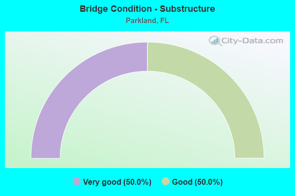
- Bridge Condition - Substructure
- 50.0%Very good
- 50.0%Good
Find on map >> Show street view
Structure Number: 860285, Location: 1 mi. North of SR-810 (Lat: 26.327606, Lng: -80.203031), Route carried "on" structure: US 441, Year Built: 1989, Status: Open, Structure Length: 4.51m (14.80ft), Average Daily Traffic: 28,250 (year 2021), Truck Traffic: 6%, Average Future Daily Traffic: 49,014 (year 2042), Design Load: HS 20+Mod, Features Intersected: Hillsboro Canal
Minimum Vertical Clearance: 30+ m (98+ ft), Kilometerpoint: 39.556, Lanes on structure: 3, Base Highway Network: Yes, Owner: State Highway Agency, Approaching Roadway Width: 11.9m (39.0ft), Skew: 20 degrees, Material/Design: Prestressed concrete, Design/Construction: Stringer/Multi-beam, Number Of Spans In Main Unit: 3, Length of Maximum Span: 15.0m (49.2ft), Curb or Sidewalk Widths: Left: 1.6m (5.2ft), Right: 0.0m, Curb-To-Curb Width: 16.1m (52.8ft), Out-to-Out Width: 20.3m (66.6ft)
Condition: Deck: Good, Superstructure: Good, Substructure: Good, Channel: Good, Operating Rating: 52.9 metric tons, Method Used To Determine Operating Rating: Load Factor (LF), Inventory Rating: 46.4 metric tons, Method Used To Determine Inventory Rating: Load Factor (LF), Structural Evaluation: Better than present minimum criteria, Deck Geometry: Better than present minimum criteria, Waterway Adequacy: Superior to present desirable criteria, Approach Roadway Alignment: Equal to present desirable criteria, Designated Inspection Frequency: Every 24 months, Underwater Inspection Frequency: Every 24 months, Inspection Date: September 2021, Underwater Inspection Date: September 2021, Deck Structure Type: Concrete Cast-file-Place
Find on map >> Show street view
Structure Number: 860286, Location: 1 mi. North of SR-810 (Lat: 26.327817, Lng: -80.202792), Route carried "on" structure: US 441, Year Built: 1989, Status: Open, Structure Length: 4.51m (14.80ft), Average Daily Traffic: 28,250 (year 2021), Truck Traffic: 6%, Average Future Daily Traffic: 49,014 (year 2042), Design Load: HS 20+Mod, Features Intersected: Hillsboro Canal
Minimum Vertical Clearance: 30+ m (98+ ft), Kilometerpoint: 39.556, Lanes on structure: 3, Base Highway Network: Yes, Owner: State Highway Agency, Approaching Roadway Width: 11.9m (39.0ft), Material/Design: Prestressed concrete, Design/Construction: Stringer/Multi-beam, Number Of Spans In Main Unit: 3, Length of Maximum Span: 15.0m (49.2ft), Curb or Sidewalk Widths: Left: 0.0m, Right: 1.6m (5.2ft), Curb-To-Curb Width: 12.4m (40.7ft), Out-to-Out Width: 16.6m (54.5ft)
Condition: Deck: Good, Superstructure: Good, Substructure: Good, Channel: Good, Operating Rating: 70.5 metric tons, Method Used To Determine Operating Rating: Load Factor (LF), Inventory Rating: 42.3 metric tons, Method Used To Determine Inventory Rating: Load Factor (LF), Structural Evaluation: Better than present minimum criteria, Deck Geometry: Meets minimum limits, Waterway Adequacy: Superior to present desirable criteria, Approach Roadway Alignment: Equal to present desirable criteria, Designated Inspection Frequency: Every 24 months, Underwater Inspection Frequency: Every 24 months, Inspection Date: September 2021, Underwater Inspection Date: September 2021, Deck Structure Type: Concrete Cast-file-Place
Find on map >> Show street view
Structure Number: 860496, Location: FIRST BRIDGE W OF SR-817 (Lat: 26.301928, Lng: -80.266747), Route carried "on" structure: State highway 869, Year Built: 1986, Year Reconstructed: 2007, Status: Open, Structure Length: 5.21m (17.09ft), Average Daily Traffic: 33,750 (year 2020), Truck Traffic: 8%, Average Future Daily Traffic: 58,556 (year 2042), Design Load: HL 93, Features Intersected: CORAL SPRINGS DR
Minimum Vertical Clearance: 30+ m (98+ ft), Kilometerpoint: 23.479, Lanes on structure: 3, Lanes under structure: 4, Base Highway Network: Yes, Toll: On toll road, Owner: State Toll Authority, Approaching Roadway Width: 17.1m (56.1ft), Material/Design: Prestressed concrete, Design/Construction: Stringer/Multi-beam, Number Of Spans In Main Unit: 2, Length of Maximum Span: 26.1m (85.6ft), Curb-To-Curb Width: 17.1m (56.1ft), Out-to-Out Width: 18.0m (59.1ft)
Condition: Deck: Good, Superstructure: Good, Substructure: Very good, Operating Rating: 60.5 metric tons, Method Used To Determine Operating Rating: Load Factor (LF), Inventory Rating: 37.1 metric tons, Method Used To Determine Inventory Rating: Load Factor (LF), Structural Evaluation: Better than present minimum criteria, Deck Geometry: Equal to present minimum criteria, Underclear: Equal to present minimum criteria, Approach Roadway Alignment: Equal to present desirable criteria, Designated Inspection Frequency: Every 24 months, Inspection Date: January 2022, Deck Structure Type: Concrete Cast-file-Place
Find on map >> Show street view
Structure Number: 860497, Location: FIRST BRIDGE W OF SR-817 (Lat: 26.302278, Lng: -80.266736), Route carried "on" structure: State highway 869, Year Built: 1986, Year Reconstructed: 2007, Status: Open, Structure Length: 5.21m (17.09ft), Average Daily Traffic: 33,750 (year 2020), Truck Traffic: 8%, Average Future Daily Traffic: 58,556 (year 2042), Design Load: HL 93, Features Intersected: CORAL SPRINGS DR
Minimum Vertical Clearance: 30.18m (99.02ft), Kilometerpoint: 23.479, Lanes on structure: 3, Lanes under structure: 4, Base Highway Network: Yes, Toll: On toll road, Owner: State Toll Authority, Approaching Roadway Width: 17.1m (56.1ft), Material/Design: Prestressed concrete, Design/Construction: Stringer/Multi-beam, Number Of Spans In Main Unit: 2, Length of Maximum Span: 26.1m (85.6ft), Curb-To-Curb Width: 17.1m (56.1ft), Out-to-Out Width: 18.0m (59.1ft)
Condition: Deck: Good, Superstructure: Good, Substructure: Very good, Operating Rating: 60.5 metric tons, Method Used To Determine Operating Rating: Load Factor (LF), Inventory Rating: 37.1 metric tons, Method Used To Determine Inventory Rating: Load Factor (LF), Structural Evaluation: Better than present minimum criteria, Deck Geometry: Equal to present minimum criteria, Underclear: Equal to present minimum criteria, Approach Roadway Alignment: Equal to present desirable criteria, Designated Inspection Frequency: Every 24 months, Inspection Date: January 2022, Deck Structure Type: Concrete Cast-file-Place
Find on map >> Show street view
Structure Number: 860498, Location: 3 MI WEST OF SR-7(US-441) (Lat: 26.301708, Lng: -80.250583), Route carried "on" structure: State highway 869, Year Built: 1986, Year Reconstructed: 2007, Status: Open, Structure Length: 6.74m (22.11ft), Average Daily Traffic: 40,800 (year 2020), Truck Traffic: 8%, Average Future Daily Traffic: 70,788 (year 2042), Design Load: HL 93, Features Intersected: SR 817 UNIVERSITY DR
Minimum Vertical Clearance: 30+ m (98+ ft), Kilometerpoint: 25.085, Lanes on structure: 3, Lanes under structure: 6, Base Highway Network: Yes, Toll: On toll road, Owner: State Toll Authority, Approaching Roadway Width: 17.1m (56.1ft), Material/Design: Prestressed concrete, Design/Construction: Stringer/Multi-beam, Number Of Spans In Main Unit: 2, Length of Maximum Span: 33.7m (110.6ft), Curb-To-Curb Width: 17.1m (56.1ft), Out-to-Out Width: 18.0m (59.1ft)
Condition: Deck: Good, Superstructure: Good, Substructure: Good, Operating Rating: 65.0 metric tons, Method Used To Determine Operating Rating: Load Factor (LF), Inventory Rating: 39.0 metric tons, Method Used To Determine Inventory Rating: Load Factor (LF), Structural Evaluation: Better than present minimum criteria, Deck Geometry: Equal to present minimum criteria, Underclear: Superior to present desirable criteria, Approach Roadway Alignment: Equal to present desirable criteria, Designated Inspection Frequency: Every 24 months, Inspection Date: Febuary 2022, Deck Structure Type: Concrete Cast-file-Place
Find on map >> Show street view
Structure Number: 860499, Location: 3 MI WEST OF SR-7(US-441) (Lat: 26.302039, Lng: -80.250581), Route carried "on" structure: State highway 869, Year Built: 1986, Year Reconstructed: 2007, Status: Open, Structure Length: 6.74m (22.11ft), Average Daily Traffic: 40,800 (year 2020), Truck Traffic: 8%, Average Future Daily Traffic: 70,788 (year 2042), Design Load: HL 93, Features Intersected: SR 817 UNIVERSITY DR
Minimum Vertical Clearance: 30+ m (98+ ft), Kilometerpoint: 25.085, Lanes on structure: 3, Lanes under structure: 6, Base Highway Network: Yes, Toll: On toll road, Owner: State Toll Authority, Approaching Roadway Width: 17.1m (56.1ft), Material/Design: Prestressed concrete, Design/Construction: Stringer/Multi-beam, Number Of Spans In Main Unit: 2, Length of Maximum Span: 33.7m (110.6ft), Curb-To-Curb Width: 17.1m (56.1ft), Out-to-Out Width: 18.0m (59.1ft)
Condition: Deck: Good, Superstructure: Good, Substructure: Good, Operating Rating: 65.0 metric tons, Method Used To Determine Operating Rating: Load Factor (LF), Inventory Rating: 39.0 metric tons, Method Used To Determine Inventory Rating: Load Factor (LF), Structural Evaluation: Better than present minimum criteria, Deck Geometry: Equal to present minimum criteria, Underclear: Better than present minimum criteria, Approach Roadway Alignment: Equal to present desirable criteria, Designated Inspection Frequency: Every 24 months, Inspection Date: Febuary 2022, Deck Structure Type: Concrete Cast-file-Place
Find on map >> Show street view
Structure Number: 8605, Location: 2.1 MI W OF SR 7(US 441) (Lat: 26.301450, Lng: -80.236550), Route carried "on" structure: State highway 869, Year Built: 1986, Year Reconstructed: 2007, Status: Open, Structure Length: 5.46m (17.91ft), Average Daily Traffic: 40,800 (year 2020), Truck Traffic: 8%, Average Future Daily Traffic: 70,788 (year 2042), Design Load: HS 20, Features Intersected: RIVERSIDE DR
Minimum Vertical Clearance: 30+ m (98+ ft), Kilometerpoint: 26.491, Lanes on structure: 3, Lanes under structure: 4, Base Highway Network: Yes, Toll: On toll road, Owner: State Toll Authority, Approaching Roadway Width: 17.1m (56.1ft), Material/Design: Prestressed concrete, Design/Construction: Stringer/Multi-beam, Number Of Spans In Main Unit: 2, Length of Maximum Span: 27.3m (89.6ft), Curb-To-Curb Width: 17.5m (57.4ft), Out-to-Out Width: 18.0m (59.1ft)
Condition: Deck: Good, Superstructure: Good, Substructure: Very good, Operating Rating: 73.3 metric tons, Method Used To Determine Operating Rating: Load Factor (LF), Inventory Rating: 44.0 metric tons, Method Used To Determine Inventory Rating: Load Factor (LF), Structural Evaluation: Better than present minimum criteria, Deck Geometry: Better than present minimum criteria, Underclear: Equal to present minimum criteria, Approach Roadway Alignment: Equal to present desirable criteria, Designated Inspection Frequency: Every 24 months, Inspection Date: Febuary 2022, Deck Structure Type: Concrete Cast-file-Place
Find on map >> Show street view
Structure Number: 860501, Location: 1 MI EAST OF SR-817 (Lat: 26.301803, Lng: -80.236558), Route carried "on" structure: State highway 869, Year Built: 1986, Year Reconstructed: 2007, Status: Open, Structure Length: 5.46m (17.91ft), Average Daily Traffic: 40,800 (year 2020), Truck Traffic: 8%, Average Future Daily Traffic: 70,788 (year 2042), Design Load: HS 20, Features Intersected: RIVERSIDE DR
Minimum Vertical Clearance: 30+ m (98+ ft), Kilometerpoint: 26.491, Lanes on structure: 3, Lanes under structure: 4, Base Highway Network: Yes, Toll: On toll road, Owner: State Toll Authority, Approaching Roadway Width: 17.1m (56.1ft), Material/Design: Prestressed concrete, Design/Construction: Stringer/Multi-beam, Number Of Spans In Main Unit: 2, Length of Maximum Span: 27.3m (89.6ft), Curb-To-Curb Width: 17.1m (56.1ft), Out-to-Out Width: 18.0m (59.1ft)
Condition: Deck: Good, Superstructure: Good, Substructure: Very good, Operating Rating: 73.3 metric tons, Method Used To Determine Operating Rating: Load Factor (LF), Inventory Rating: 44.0 metric tons, Method Used To Determine Inventory Rating: Load Factor (LF), Structural Evaluation: Better than present minimum criteria, Deck Geometry: Equal to present minimum criteria, Underclear: Equal to present minimum criteria, Approach Roadway Alignment: Equal to present desirable criteria, Designated Inspection Frequency: Every 24 months, Inspection Date: Febuary 2022, Deck Structure Type: Concrete Cast-file-Place
Find on map >> Show street view
Structure Number: 860496, Location: FIRST BRIDGE W OF SR-817 (Lat: 26.301928, Lng: -80.266747), Route carried "under" structure: City street , Year Built: 1986, Structure Length: 0. m, Average Daily Traffic: 33,750 (year 2020), Truck Traffic: 8%, Features Intersected: CORAL SPRINGS DR, Facility Carried by Structure: SR869 NB SAW 14.56
Minimum Vertical Clearance: 5.09m (16.70ft), Kilometerpoint: 23.419, Lanes on structure: 3, Lanes under structure: 4, Material/Design: Prestressed concrete, Design/Construction: Stringer/Multi-beam, Length of Maximum Span: 26.1m (85.6ft)
Find on map >> Show street view
Structure Number: 860497, Location: FIRST BRIDGE W OF SR-817 (Lat: 26.302278, Lng: -80.266736), Route carried "under" structure: City street , Year Built: 1986, Structure Length: 0. m, Average Daily Traffic: 33,750 (year 2020), Truck Traffic: 8%, Features Intersected: CORAL SPRINGS DR, Facility Carried by Structure: SR869 SB SAW 14.56
Minimum Vertical Clearance: 5.03m (16.50ft), Kilometerpoint: 23.419, Lanes on structure: 3, Lanes under structure: 4, Material/Design: Prestressed concrete, Design/Construction: Stringer/Multi-beam, Length of Maximum Span: 26.1m (85.6ft)
Find on map >> Show street view
Structure Number: 860498, Location: 3 MI WEST OF SR-7(US-441) (Lat: 26.301708, Lng: -80.250583), Route carried "under" structure: State highway 817, Year Built: 1986, Structure Length: 0. m, Average Daily Traffic: 40,800 (year 2020), Truck Traffic: 8%, Features Intersected: SR 817 UNIVERSITY DR, Facility Carried by Structure: SR869 NB SAW 15.58
Minimum Vertical Clearance: 5.09m (16.70ft), Kilometerpoint: 25.022, Lanes on structure: 3, Lanes under structure: 6, Material/Design: Prestressed concrete, Design/Construction: Stringer/Multi-beam, Length of Maximum Span: 33.7m (110.6ft)
Find on map >> Show street view
Structure Number: 860499, Location: 3 MI WEST OF SR-7(US-441) (Lat: 26.302039, Lng: -80.250581), Route carried "under" structure: State highway 817, Year Built: 1986, Structure Length: 0. m, Average Daily Traffic: 40,800 (year 2020), Truck Traffic: 8%, Features Intersected: SR 817 UNIVERSITY DR, Facility Carried by Structure: SR869 SB SAW 15.58
Minimum Vertical Clearance: 5.09m (16.70ft), Kilometerpoint: 25.022, Lanes on structure: 3, Lanes under structure: 6, Material/Design: Prestressed concrete, Design/Construction: Stringer/Multi-beam, Length of Maximum Span: 33.7m (110.6ft)
Find on map >> Show street view
Structure Number: 8605, Location: 2.1 MI W OF SR 7(US 441) (Lat: 26.301450, Lng: -80.236550), Route carried "under" structure: City street , Year Built: 1986, Structure Length: 0. m, Average Daily Traffic: 40,800 (year 2020), Truck Traffic: 8%, Features Intersected: RIVERSIDE DR, Facility Carried by Structure: SR869 NB SAW 16.45
Minimum Vertical Clearance: 5.06m (16.60ft), Kilometerpoint: 26.425, Lanes on structure: 3, Lanes under structure: 4, Material/Design: Prestressed concrete, Design/Construction: Stringer/Multi-beam, Length of Maximum Span: 27.3m (89.6ft)
Find on map >> Show street view
Structure Number: 860501, Location: 1 MI EAST OF SR-817 (Lat: 26.301803, Lng: -80.236558), Route carried "under" structure: City street , Year Built: 1986, Structure Length: 0. m, Average Daily Traffic: 40,800 (year 2020), Truck Traffic: 8%, Features Intersected: RIVERSIDE DR, Facility Carried by Structure: SR869 SB SAW 16.45
Minimum Vertical Clearance: 5.06m (16.60ft), Kilometerpoint: 26.425, Lanes on structure: 3, Lanes under structure: 4, Material/Design: Prestressed concrete, Design/Construction: Stringer/Multi-beam, Length of Maximum Span: 27.3m (89.6ft)