Bridge Statistics for Paris, Pennsylvania (PA)
Condition, Traffic, Stress, Structural Evaluation, Project Costs
- National Bridge Inventory (NBI) Statistics
- 14Number of bridges
- 85ft / 25.6mTotal length
- $2,316,000Total costs
- 62,689Total average daily traffic
- 4,637Total average daily truck traffic
- National Bridge Inventory (NBI) Registered Bridges for Paris
- No street view available for this location
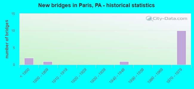
- New bridges - historical statistics
- 2Before 1900
- 11900-1909
- 11940-1949
- 101970-1979

- Reconstructed bridges - Historical Statistics
- 21990-1999
- 22000-2009
- 12010-2019


- Bridge Condition - Deck
- 37.5%Good
- 37.5%Satisfactory
- 25.0%Fair

- Bridge Condition - Superstructure
- 12.5%Very good
- 12.5%Good
- 37.5%Satisfactory
- 37.5%Fair

- Bridge Condition - Substructure
- 12.5%Good
- 62.5%Satisfactory
- 25.0%Fair

- Bridge Condition - Channel
- 25.0%Good
- 50.0%Satisfactory
- 25.0%Poor
Find on map >> Show street view
Structure Number: 34362, Location: HANOVER TOWNSHIP (Lat: 40.398731, Lng: -80.512900), Route carried "on" structure: State highway , Year Built: 1971, Status: Open, Structure Length: 7.04m (23.10ft), Average Daily Traffic: 455 (year 2021), Truck Traffic: 5%, Average Future Daily Traffic: 722 (year 2032), Design Load: HS 20, Features Intersected: SR 0022, Facility Carried by Structure: TWP RD 346/SR 4069
Minimum Vertical Clearance: 30+ m (98+ ft), Kilometerpoint: 0.000, Lanes on structure: 2, Lanes under structure: 8, Owner: State Highway Agency, Approaching Roadway Width: 6.4m (21.0ft), Material/Design: Prestressed concrete, Design/Construction: Stringer/Multi-beam, Number Of Spans In Main Unit: 4, Length of Maximum Span: 23.2m (76.1ft), Curb or Sidewalk Widths: Left: 0.2m (0.7ft), Right: 0.2m (0.7ft), Curb-To-Curb Width: 12.8m (42.0ft), Out-to-Out Width: 14.0m (45.9ft)
Condition: Deck: Satisfactory, Superstructure: Fair, Substructure: Satisfactory, Operating Rating: 42.6 metric tons, Method Used To Determine Operating Rating: Load Factor (LF), Inventory Rating: 25.4 metric tons, Method Used To Determine Inventory Rating: Load Factor (LF), Structural Evaluation: Somewhat better than minimum adequacy, Deck Geometry: Superior to present desirable criteria, Underclear: High priority of corrective action, Approach Roadway Alignment: Equal to present desirable criteria, Length Of Structure Improvement: 7.80m (25.59ft), Designated Inspection Frequency: Every 24 months, Inspection Date: October 2021, Bridge Improvement Cost: $82,000, Roadway Improvement Cost: $242,000, Total Project Cost: $1,109,000, Deck Structure Type: Concrete Cast-file-Place, Wearing Surface/Protective System: Wearing Surface: Integral Concrete
Find on map >> Show street view
Structure Number: 34363, Location: HANOVER TOWNSHIP (Lat: 40.404711, Lng: -80.485444), Route carried "on" structure: US 22, Year Built: 1971, Year Reconstructed: 2008, Status: Open, Structure Length: 3.41m (11.19ft), Average Daily Traffic: 10,168 (year 2022), Truck Traffic: 7%, Average Future Daily Traffic: 12,928 (year 2032), Design Load: HS 20, Features Intersected: SR 4005
Minimum Vertical Clearance: 30+ m (98+ ft), Kilometerpoint: 3.109, Lanes on structure: 2, Lanes under structure: 2, Base Highway Network: Yes, Owner: State Highway Agency, Approaching Roadway Width: 11.9m (39.0ft), Skew: 11 degrees, Material/Design: Prestressed concrete, Design/Construction: Stringer/Multi-beam, Number Of Spans In Main Unit: 1, Length of Maximum Span: 32.3m (106.0ft), Curb or Sidewalk Widths: Left: 0.2m (0.7ft), Right: 0.2m (0.7ft), Curb-To-Curb Width: 11.9m (39.0ft), Out-to-Out Width: 13.2m (43.3ft)
Condition: Deck: Good, Superstructure: Satisfactory, Substructure: Satisfactory, Operating Rating: 76.2 metric tons, Method Used To Determine Operating Rating: Load Factor (LF), Inventory Rating: 23.6 metric tons, Method Used To Determine Inventory Rating: Load Factor (LF), Structural Evaluation: Somewhat better than minimum adequacy, Deck Geometry: Better than present minimum criteria, Underclear: Superior to present desirable criteria, Approach Roadway Alignment: Equal to present desirable criteria, Length Of Structure Improvement: 3.40m (11.15ft), Designated Inspection Frequency: Every 24 months, Inspection Date: October 2021, Bridge Improvement Cost: $28,000, Roadway Improvement Cost: $81,000, Total Project Cost: $373,000, Deck Structure Type: Concrete Cast-file-Place, Wearing Surface/Protective System: Wearing Surface: Latex Concrete
Find on map >> Show street view
Structure Number: 34364, Location: HANOVER TOWNSHIP (Lat: 40.404850, Lng: -80.485633), Route carried "on" structure: US 22, Year Built: 1971, Year Reconstructed: 2008, Status: Open, Structure Length: 3.41m (11.19ft), Average Daily Traffic: 10,349 (year 2022), Truck Traffic: 8%, Average Future Daily Traffic: 13,972 (year 2032), Design Load: HS 20+Mod, Features Intersected: SR 4005
Minimum Vertical Clearance: 30+ m (98+ ft), Kilometerpoint: 3.088, Lanes on structure: 2, Lanes under structure: 2, Base Highway Network: Yes, Owner: State Highway Agency, Approaching Roadway Width: 11.9m (39.0ft), Skew: 11 degrees, Material/Design: Prestressed concrete, Design/Construction: Stringer/Multi-beam, Number Of Spans In Main Unit: 1, Length of Maximum Span: 32.3m (106.0ft), Curb or Sidewalk Widths: Left: 0.2m (0.7ft), Right: 0.2m (0.7ft), Curb-To-Curb Width: 11.9m (39.0ft), Out-to-Out Width: 13.2m (43.3ft)
Condition: Deck: Fair, Superstructure: Satisfactory, Substructure: Fair, Operating Rating: 75.3 metric tons, Method Used To Determine Operating Rating: Load Factor (LF), Inventory Rating: 22.7 metric tons, Method Used To Determine Inventory Rating: Load Factor (LF), Structural Evaluation: Somewhat better than minimum adequacy, Deck Geometry: Better than present minimum criteria, Underclear: Equal to present minimum criteria, Approach Roadway Alignment: Equal to present desirable criteria, Length Of Structure Improvement: 3.40m (11.15ft), Designated Inspection Frequency: Every 24 months, Inspection Date: October 2021, Bridge Improvement Cost: $36,000, Roadway Improvement Cost: $106,000, Total Project Cost: $486,000, Deck Structure Type: Concrete Cast-file-Place, Wearing Surface/Protective System: Wearing Surface: Latex Concrete
Find on map >> Show street view
Structure Number: 34365, Location: HANOVER TOWNSHIP (Lat: 40.420811, Lng: -80.453589), Route carried "on" structure: State highway , Year Built: 1971, Status: Open, Structure Length: 7.01m (23.00ft), Average Daily Traffic: 24 (year 2016), Truck Traffic: 8%, Average Future Daily Traffic: 19 (year 2032), Design Load: HS 20, Features Intersected: SR 0022, Facility Carried by Structure: TOWNSHIP ROAD 400
Minimum Vertical Clearance: 30+ m (98+ ft), Kilometerpoint: 0.000, Lanes on structure: 2, Lanes under structure: 8, Owner: State Highway Agency, Approaching Roadway Width: 9.1m (29.9ft), Material/Design: Prestressed concrete, Design/Construction: Stringer/Multi-beam, Number Of Spans In Main Unit: 4, Length of Maximum Span: 23.2m (76.1ft), Curb or Sidewalk Widths: Left: 0.2m (0.7ft), Right: 0.2m (0.7ft), Curb-To-Curb Width: 11.0m (36.1ft), Out-to-Out Width: 12.2m (40.0ft)
Condition: Deck: Good, Superstructure: Fair, Substructure: Satisfactory, Operating Rating: 78.9 metric tons, Method Used To Determine Operating Rating: Load Factor (LF), Inventory Rating: 41.7 metric tons, Method Used To Determine Inventory Rating: Load Factor (LF), Structural Evaluation: Somewhat better than minimum adequacy, Deck Geometry: Superior to present desirable criteria, Underclear: Equal to present minimum criteria, Approach Roadway Alignment: Equal to present desirable criteria, Length Of Structure Improvement: 9.40m (30.84ft), Designated Inspection Frequency: Every 24 months, Inspection Date: October 2021, Deck Structure Type: Concrete Cast-file-Place, Wearing Surface/Protective System: Wearing Surface: Monolithic Concrete
Find on map >> Show street view
Structure Number: 35286, Location: 250' SOUTH OF TR 869 (Lat: 40.459594, Lng: -80.489319), Route carried "on" structure: City street , Year Built: 1902, Year Reconstructed: 2016, Status: Open, Structure Length: 1.40m (4.59ft), Average Daily Traffic: 30 (year 2016), Average Future Daily Traffic: 30 (year 2033), Design Load: HL 93, Features Intersected: KINGS CREEK TRIB., Facility Carried by Structure: ROCK SCHOOL BRIDGE
Minimum Vertical Clearance: 30+ m (98+ ft), Kilometerpoint: 0.000, Lanes on structure: 1, Base Highway Network: Yes, Owner: County Highway Agency, Approaching Roadway Width: 3.4m (11.2ft), Material/Design: Steel, Design/Construction: Stringer/Multi-beam, Number Of Spans In Main Unit: 1, Length of Maximum Span: 12.8m (42.0ft), Curb-To-Curb Width: 3.7m (12.1ft), Out-to-Out Width: 4.0m (13.1ft)
Condition: Deck: Good, Superstructure: Very good, Substructure: Good, Channel: Satisfactory, Operating Rating: 71.7 metric tons, Method Used To Determine Operating Rating: Load Factor (LF), Inventory Rating: 42.6 metric tons, Method Used To Determine Inventory Rating: Load Factor (LF), Structural Evaluation: Better than present minimum criteria, Deck Geometry: Meets minimum limits, Waterway Adequacy: Better than present minimum criteria, Approach Roadway Alignment: Better than present minimum criteria, Length Of Structure Improvement: 2.10m (6.89ft), Designated Inspection Frequency: Every 24 months, Inspection Date: June 2021, Bridge Improvement Cost: $6,000, Roadway Improvement Cost: $17,000, Total Project Cost: $79,000, Deck Structure Type: Corrugated Steel, Wearing Surface/Protective System: Wearing Surface: Bituminous
Find on map >> Show street view
Structure Number: 35287, Location: 200' SOUTH OF TR 855 (Lat: 40.424756, Lng: -80.506656), Route carried "on" structure: City street T346, Year Built: 1887, Year Reconstructed: 1990, Status: Open, Structure Length: 0.85m (2.79ft), Average Daily Traffic: 50 (year 1993), Average Future Daily Traffic: 30 (year 2020), Features Intersected: KINGS CREEK, Facility Carried by Structure: MCCLURG BRIDGE
Minimum Vertical Clearance: 30+ m (98+ ft), Kilometerpoint: 0.000, Lanes on structure: 1, Base Highway Network: Yes, Owner: County Highway Agency, Approaching Roadway Width: 3.4m (11.2ft), Material/Design: Prestressed concrete, Design/Construction: Box Beam or Girders - Multiple, Number Of Spans In Main Unit: 1, Length of Maximum Span: 7.9m (25.9ft), Curb-To-Curb Width: 3.7m (12.1ft), Out-to-Out Width: 4.6m (15.1ft)
Condition: Deck: Satisfactory, Superstructure: Satisfactory, Substructure: Fair, Channel: Satisfactory, Operating Rating: 76.2 metric tons, Method Used To Determine Operating Rating: Field evaluation and documented engineering judgment, Inventory Rating: 45.4 metric tons, Method Used To Determine Inventory Rating: Field evaluation and documented engineering judgment, Structural Evaluation: Somewhat better than minimum adequacy, Deck Geometry: Meets minimum limits, Waterway Adequacy: Better than present minimum criteria, Approach Roadway Alignment: Equal to present desirable criteria, Length Of Structure Improvement: 1.00m (3.28ft), Designated Inspection Frequency: Every 24 months, Inspection Date: June 2021, Bridge Improvement Cost: $6,000, Roadway Improvement Cost: $18,000, Total Project Cost: $83,000, Deck Structure Type: Other, Wearing Surface/Protective System: Wearing Surface: Bituminous
Find on map >> Show street view
Structure Number: 35292, Location: 350' SOUTH OF TR 352 (Lat: 40.423903, Lng: -80.489231), Route carried "on" structure: City street T853, Year Built: 1887, Year Reconstructed: 2003, Status: Posted for load, Structure Length: 1.49m (4.89ft), Average Daily Traffic: 67 (year 2001), Average Future Daily Traffic: 60 (year 1990), Design Load: HS 15, Features Intersected: KINGS CREEK, Facility Carried by Structure: JACKSON MILL BRIDG
Minimum Vertical Clearance: 2.95m (9.68ft), Kilometerpoint: 0.000, Lanes on structure: 1, Base Highway Network: Yes, Owner: County Highway Agency, Approaching Roadway Width: 3.4m (11.2ft), Material/Design: Steel, Design/Construction: Stringer/Multi-beam, Number Of Spans In Main Unit: 1, Length of Maximum Span: 13.4m (44.0ft), Curb or Sidewalk Widths: Left: 0.2m (0.7ft), Right: 0.2m (0.7ft), Curb-To-Curb Width: 3.4m (11.2ft), Out-to-Out Width: 3.8m (12.5ft)
Condition: Deck: Satisfactory, Superstructure: Good, Substructure: Satisfactory, Channel: Good, Operating Rating: 80.7 metric tons, Method Used To Determine Operating Rating: Load Factor (LF), Inventory Rating: 48.1 metric tons, Method Used To Determine Inventory Rating: Load Factor (LF), Structural Evaluation: Equal to present minimum criteria, Deck Geometry: High priority of corrective action, Waterway Adequacy: Better than present minimum criteria, Approach Roadway Alignment: Somewhat better than minimum adequacy, Length Of Structure Improvement: 2.00m (6.56ft), Designated Inspection Frequency: Every 24 months, Other Special Inspection Frequency: Every 12 months, Inspection Date: June 2021, Other Special Inspection Date: June 2021, Bridge Improvement Cost: $9,000, Roadway Improvement Cost: $25,000, Total Project Cost: $117,000, Deck Structure Type: Wood or Timber
Find on map >> Show street view
Structure Number: 35293, Location: 600' EAST OF TR354 (Lat: 40.429769, Lng: -80.471522), Route carried "on" structure: City street T853, Year Built: 1949, Status: Posted for load, Structure Length: 1.01m (3.31ft), Average Daily Traffic: 50 (year 1990), Average Future Daily Traffic: 50 (year 2020), Design Load: HS 25 or greater, Features Intersected: KINGS CREEK, Facility Carried by Structure: Kings Creek Road
Minimum Vertical Clearance: 30+ m (98+ ft), Kilometerpoint: 0.000, Lanes on structure: 1, Base Highway Network: Yes, Owner: County Highway Agency, Approaching Roadway Width: 3.4m (11.2ft), Material/Design: Steel, Design/Construction: Stringer/Multi-beam, Number Of Spans In Main Unit: 1, Length of Maximum Span: 9.1m (29.9ft), Curb-To-Curb Width: 4.3m (14.1ft), Out-to-Out Width: 4.8m (15.7ft)
Condition: Deck: Fair, Superstructure: Fair, Substructure: Satisfactory, Channel: Poor, Operating Rating: 57.2 metric tons, Method Used To Determine Operating Rating: Load Factor (LF), Inventory Rating: 33.6 metric tons, Method Used To Determine Inventory Rating: Load Factor (LF), Structural Evaluation: Somewhat better than minimum adequacy, Deck Geometry: Equal to present minimum criteria, Waterway Adequacy: Better than present minimum criteria, Approach Roadway Alignment: Meets minimum limits, Length Of Structure Improvement: 1.60m (5.25ft), Designated Inspection Frequency: Every 24 months, Other Special Inspection Frequency: Every 12 months, Inspection Date: June 2021, Other Special Inspection Date: June 2021, Bridge Improvement Cost: $5,000, Roadway Improvement Cost: $15,000, Total Project Cost: $69,000, Deck Structure Type: Open Grating
Find on map >> Show street view
Structure Number: 34362, Location: HANOVER TOWNSHIP (Lat: 40.398731, Lng: -80.512900), Route carried "under" structure: US 22, Year Built: 1971, Structure Length: 0. m, Average Daily Traffic: 10,168 (year 2022), Truck Traffic: 7%, Features Intersected: SR 0022, Facility Carried by Structure: TWP RD 346/SR 4069
Minimum Vertical Clearance: 4.50m (14.76ft), Kilometerpoint: 0.558, Lanes on structure: 2, Lanes under structure: 4, Material/Design: Prestressed concrete, Design/Construction: Stringer/Multi-beam, Length of Maximum Span: 23.2m (76.1ft)
Find on map >> Show street view
Structure Number: 34362, Location: HANOVER TOWNSHIP (Lat: 40.398731, Lng: -80.512900), Route carried "under" structure: US 22, Year Built: 1971, Structure Length: 0. m, Average Daily Traffic: 10,349 (year 2022), Truck Traffic: 8%, Features Intersected: SR 0022, Facility Carried by Structure: TWP RD 346/SR 4069
Minimum Vertical Clearance: 4.67m (15.32ft), Kilometerpoint: 0.563, Lanes on structure: 2, Lanes under structure: 4, Material/Design: Prestressed concrete, Design/Construction: Stringer/Multi-beam, Length of Maximum Span: 23.2m (76.1ft)
Find on map >> Show street view
Structure Number: 34363, Location: HANOVER TOWNSHIP (Lat: 40.404711, Lng: -80.485444), Route carried "under" structure: State highway , Year Built: 1971, Structure Length: 0. m, Average Daily Traffic: 231 (year 2020), Features Intersected: SR 4005, Facility Carried by Structure: SR 0022
Minimum Vertical Clearance: 5.43m (17.81ft), Kilometerpoint: 6.592, Lanes on structure: 2, Lanes under structure: 2, Material/Design: Prestressed concrete, Design/Construction: Stringer/Multi-beam, Length of Maximum Span: 32.3m (106.0ft)
Find on map >> Show street view
Structure Number: 34364, Location: HANOVER TOWNSHIP (Lat: 40.404850, Lng: -80.485633), Route carried "under" structure: State highway , Year Built: 1971, Structure Length: 0. m, Average Daily Traffic: 231 (year 2020), Features Intersected: SR 4005, Facility Carried by Structure: SR 0022
Minimum Vertical Clearance: 4.60m (15.09ft), Kilometerpoint: 6.592, Lanes on structure: 2, Lanes under structure: 2, Material/Design: Prestressed concrete, Design/Construction: Stringer/Multi-beam, Length of Maximum Span: 32.3m (106.0ft)
Find on map >> Show street view
Structure Number: 34365, Location: HANOVER TOWNSHIP (Lat: 40.420811, Lng: -80.453589), Route carried "under" structure: US 22, Year Built: 1971, Structure Length: 0. m, Average Daily Traffic: 10,168 (year 2022), Truck Traffic: 7%, Features Intersected: SR 0022, Facility Carried by Structure: TOWNSHIP ROAD 400
Minimum Vertical Clearance: 4.50m (14.76ft), Kilometerpoint: 6.437, Lanes on structure: 2, Lanes under structure: 4, Material/Design: Prestressed concrete, Design/Construction: Stringer/Multi-beam, Length of Maximum Span: 23.2m (76.1ft)
Find on map >> Show street view
Structure Number: 34365, Location: HANOVER TOWNSHIP (Lat: 40.420811, Lng: -80.453589), Route carried "under" structure: US 22, Year Built: 1971, Structure Length: 0. m, Average Daily Traffic: 10,349 (year 2022), Truck Traffic: 8%, Features Intersected: SR 0022, Facility Carried by Structure: TOWNSHIP ROAD 400
Minimum Vertical Clearance: 4.60m (15.09ft), Kilometerpoint: 6.426, Lanes on structure: 2, Lanes under structure: 4, Material/Design: Prestressed concrete, Design/Construction: Stringer/Multi-beam, Length of Maximum Span: 23.2m (76.1ft)