Bridge Statistics for Pardeesville, Pennsylvania (PA)
Condition, Traffic, Stress, Structural Evaluation, Project Costs
- National Bridge Inventory (NBI) Statistics
- 22Number of bridges
- 177ft / 53.7mTotal length
- $4,567,000Total costs
- 269,812Total average daily traffic
- 105,994Total average daily truck traffic
- National Bridge Inventory (NBI) Registered Bridges for Pardeesville
- No street view available for this location
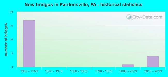
- New bridges - historical statistics
- 171960-1969
- 12000-2009
- 42010-2019

- Reconstructed bridges - Historical Statistics
- 61970-1979
- 01980-1989
- 11990-1999
- 12000-2009


- Bridge Condition - Deck
- 18.2%Very good
- 18.2%Good
- 18.2%Satisfactory
- 27.3%Fair
- 18.2%Poor

- Bridge Condition - Superstructure
- 18.2%Very good
- 18.2%Good
- 45.5%Satisfactory
- 9.1%Fair
- 9.1%Serious

- Bridge Condition - Substructure
- 18.2%Very good
- 9.1%Good
- 27.3%Satisfactory
- 36.4%Fair
- 9.1%Poor

- Bridge Condition - Channel
- 66.7%Satisfactory
- 16.7%Fair
- 16.7%Poor

- Bridge Condition - Culverts
- 50.0%Very good
- 50.0%Fair
Find on map >> Show street view
Structure Number: 23658, Location: BUTLER TWP OVER I-81 (Lat: 41.045114, Lng: -76.014517), Route carried "on" structure: Interstate 80, Year Built: 1965, Year Reconstructed: 1990, Status: Open, Structure Length: 7.99m (26.21ft), Average Daily Traffic: 11,427 (year 2021), Truck Traffic: 47%, Average Future Daily Traffic: 14,273 (year 2032), Design Load: HS 20+Mod, Features Intersected: SR 0081 I-81 EXIT 151A
Minimum Vertical Clearance: 30+ m (98+ ft), Kilometerpoint: 19.702, Lanes on structure: 3, Lanes under structure: 5, Base Highway Network: Yes, Owner: State Highway Agency, Approaching Roadway Width: 17.7m (58.1ft), Skew: 3 degrees, Material/Design: Prestressed concrete, Design/Construction: Stringer/Multi-beam, Number Of Spans In Main Unit: 4, Length of Maximum Span: 27.7m (90.9ft), Curb or Sidewalk Widths: Left: 0.2m (0.7ft), Right: 0.2m (0.7ft), Curb-To-Curb Width: 15.5m (50.9ft), Out-to-Out Width: 19.2m (63.0ft)
Condition: Deck: Poor, Superstructure: Fair, Substructure: Fair, Operating Rating: 64.4 metric tons, Method Used To Determine Operating Rating: Load Factor (LF), Inventory Rating: 13.6 metric tons, Method Used To Determine Inventory Rating: Load Factor (LF), Structural Evaluation: High priority of corrective action, Deck Geometry: Somewhat better than minimum adequacy, Underclear: High priority of corrective action, Approach Roadway Alignment: Equal to present desirable criteria, Length Of Structure Improvement: 8.90m (29.20ft), Designated Inspection Frequency: Every 24 months, Inspection Date: September 2021, Bridge Improvement Cost: $27,000, Roadway Improvement Cost: $80,000, Total Project Cost: $366,000, Deck Structure Type: Concrete Cast-file-Place, Wearing Surface/Protective System: Wearing Surface: Latex Concrete
Find on map >> Show street view
Structure Number: 23687, Location: BUTLER TWP 2 M N TR 93 (Lat: 40.999731, Lng: -76.008136), Route carried "on" structure: Interstate 81, Year Built: 1965, Year Reconstructed: 1981, Status: Open, Structure Length: 3.87m (12.70ft), Average Daily Traffic: 19,648 (year 2021), Truck Traffic: 39%, Average Future Daily Traffic: 21,996 (year 2032), Design Load: HS 20+Mod, Features Intersected: W. FOOTHILLS DRIVE
Minimum Vertical Clearance: 30+ m (98+ ft), Kilometerpoint: 12.638, Lanes on structure: 2, Lanes under structure: 2, Base Highway Network: Yes, Owner: State Highway Agency, Approaching Roadway Width: 13.4m (44.0ft), Skew: 12 degrees, Material/Design: Prestressed concrete, Design/Construction: Box Beam or Girders - Single/Spread, Number Of Spans In Main Unit: 3, Length of Maximum Span: 13.7m (44.9ft), Curb or Sidewalk Widths: Left: 0.2m (0.7ft), Right: 0.2m (0.7ft), Curb-To-Curb Width: 12.4m (40.7ft), Out-to-Out Width: 13.9m (45.6ft)
Condition: Deck: Poor, Superstructure: Serious, Substructure: Poor, Operating Rating: 51.7 metric tons, Method Used To Determine Operating Rating: Load Factor (LF), Inventory Rating: 30.8 metric tons, Method Used To Determine Inventory Rating: Load Factor (LF), Structural Evaluation: High priority of corrective action, Deck Geometry: Better than present minimum criteria, Underclear: Meets minimum limits, Approach Roadway Alignment: Better than present minimum criteria, Length Of Structure Improvement: 3.90m (12.80ft), Designated Inspection Frequency: Every 24 months, Other Special Inspection Frequency: Every 6 months, Inspection Date: August 2021, Other Special Inspection Date: August 2021, Bridge Improvement Cost: $33,000, Roadway Improvement Cost: $100,000, Total Project Cost: $449,000, Deck Structure Type: Concrete Cast-file-Place, Wearing Surface/Protective System: Wearing Surface: Latex Concrete
Find on map >> Show street view
Structure Number: 23688, Location: BUTLER TWP 2 M N TR 93 (Lat: 40.999928, Lng: -76.008353), Route carried "on" structure: Interstate 81, Year Built: 1965, Year Reconstructed: 1981, Status: Open, Structure Length: 3.78m (12.40ft), Average Daily Traffic: 19,371 (year 2021), Truck Traffic: 39%, Average Future Daily Traffic: 23,631 (year 2032), Design Load: HS 20+Mod, Features Intersected: COUNTY ROAD
Minimum Vertical Clearance: 30+ m (98+ ft), Kilometerpoint: 12.656, Lanes on structure: 2, Lanes under structure: 2, Base Highway Network: Yes, Owner: State Highway Agency, Approaching Roadway Width: 11.6m (38.1ft), Skew: 13 degrees, Material/Design: Prestressed concrete, Design/Construction: Box Beam or Girders - Single/Spread, Number Of Spans In Main Unit: 3, Length of Maximum Span: 14.0m (45.9ft), Curb or Sidewalk Widths: Left: 0.2m (0.7ft), Right: 0.2m (0.7ft), Curb-To-Curb Width: 12.5m (41.0ft), Out-to-Out Width: 13.9m (45.6ft)
Condition: Deck: Satisfactory, Superstructure: Good, Substructure: Satisfactory, Operating Rating: 65.3 metric tons, Method Used To Determine Operating Rating: Load Factor (LF), Inventory Rating: 29.9 metric tons, Method Used To Determine Inventory Rating: Load Factor (LF), Structural Evaluation: Equal to present minimum criteria, Deck Geometry: Better than present minimum criteria, Underclear: High priority of corrective action, Approach Roadway Alignment: Better than present minimum criteria, Length Of Structure Improvement: 4.70m (15.42ft), Designated Inspection Frequency: Every 24 months, Inspection Date: September 2021, Bridge Improvement Cost: $42,000, Roadway Improvement Cost: $123,000, Total Project Cost: $565,000, Deck Structure Type: Concrete Cast-file-Place, Wearing Surface/Protective System: Wearing Surface: Latex Concrete
Find on map >> Show street view
Structure Number: 23689, Location: BUTLER TWP 2.5 M N TR 93 (Lat: 41.005289, Lng: -76.007461), Route carried "on" structure: Interstate 81, Year Built: 1965, Status: Open, Structure Length: 0.94m (3.08ft), Average Daily Traffic: 39,019 (year 2021), Truck Traffic: 39%, Average Future Daily Traffic: 45,627 (year 2032), Design Load: HS 20+Mod, Features Intersected: LITTLE NESCOPECK CREEK
Minimum Vertical Clearance: 30+ m (98+ ft), Kilometerpoint: 13.443, Lanes on structure: 2, Base Highway Network: Yes, Owner: State Highway Agency, Approaching Roadway Width: 23.2m (76.1ft), Skew: 21 degrees, Material/Design: Concrete, Design/Construction: Culvert, Number Of Spans In Main Unit: 1, Length of Maximum Span: 9.4m (30.8ft)
Condition: Channel: Poor, Culverts: Fair, Operating Rating: 49.0 metric tons, Method Used To Determine Operating Rating: Field evaluation and documented engineering judgment, Inventory Rating: 32.7 metric tons, Method Used To Determine Inventory Rating: Field evaluation and documented engineering judgment, Structural Evaluation: Somewhat better than minimum adequacy, Waterway Adequacy: Superior to present desirable criteria, Approach Roadway Alignment: Equal to present desirable criteria, Length Of Structure Improvement: 1.60m (5.25ft), Designated Inspection Frequency: Every 24 months, Inspection Date: September 2021
Find on map >> Show street view
Structure Number: 2369, Location: BUTLER TWP .5 M S SR 3040 (Lat: 41.021731, Lng: -76.009792), Route carried "on" structure: Interstate 81, Year Built: 1965, Year Reconstructed: 1982, Status: Open, Structure Length: 12.44m (40.81ft), Average Daily Traffic: 19,648 (year 2021), Truck Traffic: 39%, Average Future Daily Traffic: 21,996 (year 2032), Design Load: HS 20+Mod, Features Intersected: NESCOPECK CREEK
Minimum Vertical Clearance: 30+ m (98+ ft), Kilometerpoint: 15.041, Lanes on structure: 2, Base Highway Network: Yes, Owner: State Highway Agency, Approaching Roadway Width: 11.0m (36.1ft), Skew: 10 degrees, Material/Design: Prestressed concrete, Design/Construction: Stringer/Multi-beam, Number Of Spans In Main Unit: 5, Length of Maximum Span: 24.1m (79.1ft), Curb or Sidewalk Widths: Left: 0.2m (0.7ft), Right: 0.2m (0.7ft), Curb-To-Curb Width: 10.0m (32.8ft), Out-to-Out Width: 11.4m (37.4ft)
Condition: Deck: Fair, Superstructure: Satisfactory, Substructure: Fair, Channel: Satisfactory, Operating Rating: 96.2 metric tons, Method Used To Determine Operating Rating: Load Factor (LF), Inventory Rating: 27.2 metric tons, Method Used To Determine Inventory Rating: Load Factor (LF), Structural Evaluation: Somewhat better than minimum adequacy, Deck Geometry: Meets minimum limits, Waterway Adequacy: Superior to present desirable criteria, Approach Roadway Alignment: Equal to present desirable criteria, Length Of Structure Improvement: 12.40m (40.68ft), Designated Inspection Frequency: Every 24 months, Inspection Date: September 2021, Bridge Improvement Cost: $109,000, Roadway Improvement Cost: $322,000, Total Project Cost: $1,474,000, Deck Structure Type: Concrete Cast-file-Place, Wearing Surface/Protective System: Wearing Surface: Latex Concrete
Find on map >> Show street view
Structure Number: 23691, Location: BUTLER TWP 1.5 M S I-80 (Lat: 41.021733, Lng: -76.010119), Route carried "on" structure: Interstate 81, Year Built: 1965, Year Reconstructed: 1981, Status: Open, Structure Length: 10.52m (34.51ft), Average Daily Traffic: 19,371 (year 2021), Truck Traffic: 39%, Average Future Daily Traffic: 23,631 (year 2032), Design Load: HS 20+Mod, Features Intersected: NESCOPECK CREEK
Minimum Vertical Clearance: 30+ m (98+ ft), Kilometerpoint: 15.018, Lanes on structure: 2, Base Highway Network: Yes, Owner: State Highway Agency, Approaching Roadway Width: 10.7m (35.1ft), Skew: 10 degrees, Material/Design: Prestressed concrete, Design/Construction: Stringer/Multi-beam, Number Of Spans In Main Unit: 4, Length of Maximum Span: 25.6m (84.0ft), Curb or Sidewalk Widths: Left: 0.2m (0.7ft), Right: 0.2m (0.7ft), Curb-To-Curb Width: 10.0m (32.8ft), Out-to-Out Width: 11.4m (37.4ft)
Condition: Deck: Satisfactory, Superstructure: Satisfactory, Substructure: Fair, Channel: Satisfactory, Operating Rating: 94.3 metric tons, Method Used To Determine Operating Rating: Load Factor (LF), Inventory Rating: 26.3 metric tons, Method Used To Determine Inventory Rating: Load Factor (LF), Structural Evaluation: Somewhat better than minimum adequacy, Deck Geometry: Meets minimum limits, Waterway Adequacy: Superior to present desirable criteria, Approach Roadway Alignment: Equal to present desirable criteria, Length Of Structure Improvement: 10.50m (34.45ft), Designated Inspection Frequency: Every 24 months, Inspection Date: September 2021, Bridge Improvement Cost: $92,000, Roadway Improvement Cost: $272,000, Total Project Cost: $1,245,000, Deck Structure Type: Concrete Cast-file-Place, Wearing Surface/Protective System: Wearing Surface: Latex Concrete
Find on map >> Show street view
Structure Number: 23692, Location: BUTLER TWP OVER TB 3040 (Lat: 41.027053, Lng: -76.010183), Route carried "on" structure: Interstate 81, Year Built: 1965, Year Reconstructed: 1981, Status: Open, Structure Length: 1.10m (3.61ft), Average Daily Traffic: 19,648 (year 2021), Truck Traffic: 39%, Average Future Daily Traffic: 21,996 (year 2032), Design Load: HS 20+Mod, Features Intersected: TURNBACK 3040 TWP ROAD
Minimum Vertical Clearance: 30+ m (98+ ft), Kilometerpoint: 15.839, Lanes on structure: 2, Lanes under structure: 2, Base Highway Network: Yes, Owner: State Highway Agency, Approaching Roadway Width: 12.8m (42.0ft), Skew: 12 degrees, Material/Design: Prestressed concrete, Design/Construction: Box Beam or Girders - Single/Spread, Number Of Spans In Main Unit: 1, Length of Maximum Span: 9.8m (32.2ft), Curb or Sidewalk Widths: Left: 0.2m (0.7ft), Right: 0.2m (0.7ft), Curb-To-Curb Width: 12.4m (40.7ft), Out-to-Out Width: 13.9m (45.6ft)
Condition: Deck: Fair, Superstructure: Satisfactory, Substructure: Fair, Operating Rating: 53.5 metric tons, Method Used To Determine Operating Rating: Load Factor (LF), Inventory Rating: 31.8 metric tons, Method Used To Determine Inventory Rating: Load Factor (LF), Structural Evaluation: Somewhat better than minimum adequacy, Deck Geometry: Better than present minimum criteria, Underclear: Meets minimum limits, Approach Roadway Alignment: Equal to present desirable criteria, Length Of Structure Improvement: 1.70m (5.58ft), Designated Inspection Frequency: Every 24 months, Inspection Date: September 2021, Deck Structure Type: Concrete Cast-file-Place, Wearing Surface/Protective System: Wearing Surface: Latex Concrete
Find on map >> Show street view
Structure Number: 23694, Location: BUTLER TWP OVER TB 3040 (Lat: 41.027311, Lng: -76.010575), Route carried "on" structure: Interstate 81, Year Built: 1965, Year Reconstructed: 1981, Status: Open, Structure Length: 1.10m (3.61ft), Average Daily Traffic: 19,371 (year 2021), Truck Traffic: 39%, Average Future Daily Traffic: 23,631 (year 2032), Design Load: HS 20+Mod, Features Intersected: TURNBACK 3040 TWP ROAD
Minimum Vertical Clearance: 30+ m (98+ ft), Kilometerpoint: 15.783, Lanes on structure: 2, Lanes under structure: 2, Base Highway Network: Yes, Owner: State Highway Agency, Approaching Roadway Width: 12.8m (42.0ft), Skew: 12 degrees, Material/Design: Prestressed concrete, Design/Construction: Box Beam or Girders - Single/Spread, Number Of Spans In Main Unit: 1, Length of Maximum Span: 9.8m (32.2ft), Curb or Sidewalk Widths: Left: 0.2m (0.7ft), Right: 0.2m (0.7ft), Curb-To-Curb Width: 12.4m (40.7ft), Out-to-Out Width: 13.9m (45.6ft)
Condition: Deck: Fair, Superstructure: Satisfactory, Substructure: Satisfactory, Operating Rating: 53.5 metric tons, Method Used To Determine Operating Rating: Load Factor (LF), Inventory Rating: 31.8 metric tons, Method Used To Determine Inventory Rating: Load Factor (LF), Structural Evaluation: Equal to present minimum criteria, Deck Geometry: Better than present minimum criteria, Underclear: Meets minimum limits, Approach Roadway Alignment: Equal to present desirable criteria, Length Of Structure Improvement: 1.70m (5.58ft), Designated Inspection Frequency: Every 24 months, Inspection Date: September 2021, Bridge Improvement Cost: $21,000, Roadway Improvement Cost: $100,000, Total Project Cost: $279,000, Deck Structure Type: Concrete Cast-file-Place, Wearing Surface/Protective System: Wearing Surface: Latex Concrete
Find on map >> Show street view
Structure Number: 23702, Location: BUTLER TWP OVER I-80 WB (Lat: 41.046689, Lng: -76.013431), Route carried "on" structure: Interstate 81, Year Built: 1965, Year Reconstructed: 2011, Status: Open, Structure Length: 2.87m (9.42ft), Average Daily Traffic: 18,995 (year 2021), Truck Traffic: 38%, Average Future Daily Traffic: 28,779 (year 2032), Design Load: HS 20+Mod, Features Intersected: SR 0080 I-80 WB
Minimum Vertical Clearance: 30+ m (98+ ft), Kilometerpoint: 18.198, Lanes on structure: 3, Lanes under structure: 3, Base Highway Network: Yes, Owner: State Highway Agency, Approaching Roadway Width: 15.5m (50.9ft), Skew: 14 degrees, Material/Design: Prestressed concrete, Design/Construction: Stringer/Multi-beam, Number Of Spans In Main Unit: 1, Length of Maximum Span: 28.0m (91.9ft), Curb or Sidewalk Widths: Left: 0.2m (0.7ft), Right: 0.2m (0.7ft), Curb-To-Curb Width: 15.3m (50.2ft), Out-to-Out Width: 16.3m (53.5ft)
Condition: Deck: Good, Superstructure: Satisfactory, Substructure: Satisfactory, Operating Rating: 96.2 metric tons, Method Used To Determine Operating Rating: Load Factor (LF), Inventory Rating: 24.5 metric tons, Method Used To Determine Inventory Rating: Load Factor (LF), Structural Evaluation: Equal to present minimum criteria, Deck Geometry: Meets minimum limits, Underclear: Equal to present minimum criteria, Approach Roadway Alignment: Equal to present desirable criteria, Length Of Structure Improvement: 3.60m (11.81ft), Designated Inspection Frequency: Every 24 months, Inspection Date: September 2021, Bridge Improvement Cost: $14,000, Roadway Improvement Cost: $41,000, Total Project Cost: $189,000, Deck Structure Type: Concrete Cast-file-Place, Wearing Surface/Protective System: Wearing Surface: Monolithic Concrete, Deck Protection: Epoxy Coated Reinforcing
Find on map >> Show street view
Structure Number: 41823, Location: BUTLER TWP .6 M W SR 3021 (Lat: 41.029675, Lng: -76.000725), Route carried "on" structure: State highway , Year Built: 2002, Status: Open, Structure Length: 0.70m (2.30ft), Average Daily Traffic: 1,572 (year 2020), Truck Traffic: 4%, Average Future Daily Traffic: 1,517 (year 2033), Design Load: HS 25 or greater, Features Intersected: LONG RUN, Facility Carried by Structure: SR3040 ST JOHNS RD
Minimum Vertical Clearance: 30+ m (98+ ft), Kilometerpoint: 0.011, Lanes on structure: 2, Owner: State Highway Agency, Approaching Roadway Width: 6.4m (21.0ft), Skew: 1 degrees, Material/Design: Concrete, Design/Construction: Culvert, Number Of Spans In Main Unit: 1, Length of Maximum Span: 7.0m (23.0ft), Curb-To-Curb Width: 10.5m (34.4ft), Out-to-Out Width: 12.1m (39.7ft)
Condition: Channel: Fair, Culverts: Very good, Operating Rating: 82.6 metric tons, Method Used To Determine Operating Rating: Load Factor (LF), Inventory Rating: 49.0 metric tons, Method Used To Determine Inventory Rating: Load Factor (LF), Structural Evaluation: Equal to present desirable criteria, Deck Geometry: Equal to present minimum criteria, Waterway Adequacy: Better than present minimum criteria, Approach Roadway Alignment: Equal to present desirable criteria, Length Of Structure Improvement: 0.70m (2.30ft), Designated Inspection Frequency: Every 48 months, Inspection Date: January 2019
Find on map >> Show street view
Structure Number: 48963, Location: PARALLEL TO I-81 (Lat: 41.020800, Lng: -76.011097), Route carried "on" structure: County highway , Year Built: 2014, Status: Open, Structure Length: 2.87m (9.42ft), Average Daily Traffic: 500 (year 2015), Truck Traffic: 2%, Average Future Daily Traffic: 700 (year 2033), Design Load: HL 93, Features Intersected: NESCOPECK CREEK, Facility Carried by Structure: N. BEISELS (CR 39)
Minimum Vertical Clearance: 30+ m (98+ ft), Kilometerpoint: 0.000, Lanes on structure: 2, Owner: County Highway Agency, Approaching Roadway Width: 6.1m (20.0ft), Skew: 4 degrees, Material/Design: Prestressed concrete, Design/Construction: Stringer/Multi-beam, Number Of Spans In Main Unit: 1, Length of Maximum Span: 27.4m (89.9ft), Curb-To-Curb Width: 7.5m (24.6ft), Out-to-Out Width: 8.4m (27.6ft)
Condition: Deck: Good, Superstructure: Good, Substructure: Good, Channel: Satisfactory, Operating Rating: 52.2 metric tons, Method Used To Determine Operating Rating: Assigned ratings based on Load and Resistance Factor Design (LRFD) reported by rating factor (RF) using HL93 loadings, Inventory Rating: 34.3 metric tons, Method Used To Determine Inventory Rating: Assigned ratings based on Load and Resistance Factor Design (LRFD) reported by rating factor (RF) using HL93 loadings, Structural Evaluation: Better than present minimum criteria, Deck Geometry: Meets minimum limits, Waterway Adequacy: Superior to present desirable criteria, Approach Roadway Alignment: Equal to present desirable criteria, Designated Inspection Frequency: Every 24 months, Inspection Date: May 2021, Deck Structure Type: Concrete Cast-file-Place, Wearing Surface/Protective System: Wearing Surface: Monolithic Concrete, Deck Protection: Epoxy Coated Reinforcing
Find on map >> Show street view
Structure Number: 53455, Location: BUTLER TWP OVER I-80 WB (Lat: 41.047822, Lng: -76.009147), Route carried "on" structure: Ramp State highway , Year Built: 2017, Status: Open, Structure Length: 2.96m (9.71ft), Average Daily Traffic: 8,023 (year 2021), Truck Traffic: 7%, Average Future Daily Traffic: 6,974 (year 2037), Design Load: HL 93, Features Intersected: SR 0080 I-80 WB, Facility Carried by Structure: SR 8005 RAMP E
Minimum Vertical Clearance: 30+ m (98+ ft), Kilometerpoint: 0.000, Lanes on structure: 1, Lanes under structure: 2, Base Highway Network: Yes, Owner: State Highway Agency, Maintenance Responsibility: Private, Approaching Roadway Width: 11.6m (38.1ft), Skew: 4 degrees, Material/Design: Prestressed concrete, Design/Construction: Stringer/Multi-beam, Number Of Spans In Main Unit: 1, Length of Maximum Span: 28.7m (94.2ft), Curb-To-Curb Width: 12.8m (42.0ft), Out-to-Out Width: 13.8m (45.3ft)
Condition: Deck: Very good, Superstructure: Very good, Substructure: Very good, Operating Rating: 54.8 metric tons, Method Used To Determine Operating Rating: Assigned ratings based on Load and Resistance Factor Design (LRFD) reported by rating factor (RF) using HL93 loadings, Inventory Rating: 42.1 metric tons, Method Used To Determine Inventory Rating: Assigned ratings based on Load and Resistance Factor Design (LRFD) reported by rating factor (RF) using HL93 loadings, Structural Evaluation: Equal to present desirable criteria, Deck Geometry: Superior to present desirable criteria, Underclear: Equal to present minimum criteria, Approach Roadway Alignment: Somewhat better than minimum adequacy, Designated Inspection Frequency: Every 24 months, Inspection Date: March 2020, Deck Structure Type: Concrete Cast-file-Place, Wearing Surface/Protective System: Wearing Surface: Integral Concrete, Deck Protection: Epoxy Coated Reinforcing
Find on map >> Show street view
Structure Number: 54688, Location: BUTLER TWP 300' S SR 3040 (Lat: 41.029167, Lng: -75.990069), Route carried "on" structure: State highway , Year Built: 2017, Status: Open, Structure Length: 2.59m (8.50ft), Average Daily Traffic: 2,250 (year 2021), Truck Traffic: 4%, Average Future Daily Traffic: 1,488 (year 2033), Design Load: HL 93, Features Intersected: NESCOPECK CREEK, Facility Carried by Structure: SR 3021
Minimum Vertical Clearance: 30+ m (98+ ft), Kilometerpoint: 4.577, Lanes on structure: 2, Owner: State Highway Agency, Approaching Roadway Width: 6.1m (20.0ft), Skew: 1 degrees, Material/Design: Prestressed concrete, Design/Construction: Box Beam or Girders - Single/Spread, Number Of Spans In Main Unit: 1, Length of Maximum Span: 25.0m (82.0ft), Curb or Sidewalk Widths: Left: 0.2m (0.7ft), Right: 0.2m (0.7ft), Curb-To-Curb Width: 8.2m (26.9ft), Out-to-Out Width: 9.3m (30.5ft)
Condition: Deck: Very good, Superstructure: Very good, Substructure: Very good, Channel: Satisfactory, Operating Rating: 52.5 metric tons, Method Used To Determine Operating Rating: Assigned ratings based on Load and Resistance Factor Design (LRFD) reported by rating factor (RF) using HL93 loadings, Inventory Rating: 38.9 metric tons, Method Used To Determine Inventory Rating: Assigned ratings based on Load and Resistance Factor Design (LRFD) reported by rating factor (RF) using HL93 loadings, Structural Evaluation: Equal to present desirable criteria, Deck Geometry: High priority of corrective action, Waterway Adequacy: Better than present minimum criteria, Approach Roadway Alignment: Equal to present desirable criteria, Designated Inspection Frequency: Every 48 months, Inspection Date: November 2019, Deck Structure Type: Concrete Cast-file-Place, Wearing Surface/Protective System: Wearing Surface: Monolithic Concrete, Membrane: Built-up, Deck Protection: Epoxy Coated Reinforcing
Find on map >> Show street view
Structure Number: 23658, Location: BUTLER TWP OVER I-81 (Lat: 41.045114, Lng: -76.014517), Route carried "under" structure: Interstate 81, Year Built: 1965, Structure Length: 0. m, Average Daily Traffic: 17,034 (year 2021), Truck Traffic: 47%, Features Intersected: SR 0081 I-81 EXIT 151A, Facility Carried by Structure: SR 0080 I-80 EB
Minimum Vertical Clearance: 5.11m (16.77ft), Kilometerpoint: 17.436, Lanes on structure: 3, Lanes under structure: 2, Material/Design: Prestressed concrete, Design/Construction: Stringer/Multi-beam, Length of Maximum Span: 27.7m (90.9ft)
Find on map >> Show street view
Structure Number: 23658, Location: BUTLER TWP OVER I-81 (Lat: 41.045114, Lng: -76.014517), Route carried "under" structure: Interstate 81, Year Built: 1965, Structure Length: 0. m, Average Daily Traffic: 18,995 (year 2021), Truck Traffic: 38%, Features Intersected: SR 0081 I-81 EXIT 151A, Facility Carried by Structure: SR 0080 I-80 EB
Minimum Vertical Clearance: 5.11m (16.77ft), Kilometerpoint: 17.418, Lanes on structure: 3, Lanes under structure: 3, Material/Design: Prestressed concrete, Design/Construction: Stringer/Multi-beam, Length of Maximum Span: 27.7m (90.9ft)
Find on map >> Show street view
Structure Number: 23687, Location: BUTLER TWP 2 M N TR 93 (Lat: 40.999731, Lng: -76.008136), Route carried "under" structure: City street , Year Built: 1965, Structure Length: 0. m, Average Daily Traffic: 200 (year 1992), Truck Traffic: 1%, Features Intersected: W. FOOTHILLS DRIVE, Facility Carried by Structure: I-81 NB
Minimum Vertical Clearance: 4.88m (16.01ft), Kilometerpoint: 0.000, Lanes on structure: 2, Lanes under structure: 2, Material/Design: Prestressed concrete, Design/Construction: Box Beam or Girders - Single/Spread, Length of Maximum Span: 13.7m (44.9ft)
Find on map >> Show street view
Structure Number: 23688, Location: BUTLER TWP 2 M N TR 93 (Lat: 40.999928, Lng: -76.008353), Route carried "under" structure: County highway , Year Built: 1965, Structure Length: 0. m, Average Daily Traffic: 200 (year 1992), Truck Traffic: 1%, Features Intersected: COUNTY ROAD, Facility Carried by Structure: SR 0081 I-81 SB
Minimum Vertical Clearance: 4.57m (14.99ft), Kilometerpoint: 0.000, Lanes on structure: 2, Lanes under structure: 2, Material/Design: Prestressed concrete, Design/Construction: Box Beam or Girders - Single/Spread, Length of Maximum Span: 14.0m (45.9ft)
Find on map >> Show street view
Structure Number: 23692, Location: BUTLER TWP OVER TB 3040 (Lat: 41.027053, Lng: -76.010183), Route carried "under" structure: City street , Year Built: 1965, Structure Length: 0. m, Average Daily Traffic: 650 (year 2005), Truck Traffic: 10%, Features Intersected: TURNBACK 3040 TWP ROAD, Facility Carried by Structure: I-81 NB
Minimum Vertical Clearance: 5.94m (19.49ft), Kilometerpoint: 0.000, Lanes on structure: 2, Lanes under structure: 2, Material/Design: Prestressed concrete, Design/Construction: Box Beam or Girders - Single/Spread, Length of Maximum Span: 9.8m (32.2ft)
Find on map >> Show street view
Structure Number: 23694, Location: BUTLER TWP OVER TB 3040 (Lat: 41.027311, Lng: -76.010575), Route carried "under" structure: City street , Year Built: 1965, Structure Length: 0. m, Average Daily Traffic: 200 (year 1992), Truck Traffic: 10%, Features Intersected: TURNBACK 3040 TWP ROAD, Facility Carried by Structure: I-81 SB
Minimum Vertical Clearance: 5.00m (16.40ft), Kilometerpoint: 0.000, Lanes on structure: 2, Lanes under structure: 2, Material/Design: Prestressed concrete, Design/Construction: Box Beam or Girders - Single/Spread, Length of Maximum Span: 9.8m (32.2ft)
Find on map >> Show street view
Structure Number: 23699, Location: BUTLER TWP OVER I-80 WB (Lat: 41.046828, Lng: -76.012928), Route carried "under" structure: Interstate 80, Year Built: 1965, Structure Length: 0. m, Average Daily Traffic: 11,230 (year 2021), Truck Traffic: 49%, Features Intersected: I-80 WB, Facility Carried by Structure: I-81 NB
Minimum Vertical Clearance: 5.24m (17.19ft), Kilometerpoint: 19.734, Lanes on structure: 2, Lanes under structure: 3, Material/Design: Prestressed concrete, Design/Construction: Stringer/Multi-beam, Length of Maximum Span: 29.0m (95.1ft)
Find on map >> Show street view
Structure Number: 23702, Location: BUTLER TWP OVER I-80 WB (Lat: 41.046689, Lng: -76.013431), Route carried "under" structure: Interstate 80, Year Built: 1965, Structure Length: 0. m, Average Daily Traffic: 11,230 (year 2021), Truck Traffic: 49%, Features Intersected: SR 0080 I-80 WB, Facility Carried by Structure: SR 0081 I-81 SB
Minimum Vertical Clearance: 5.49m (18.01ft), Kilometerpoint: 19.734, Lanes on structure: 3, Lanes under structure: 3, Material/Design: Prestressed concrete, Design/Construction: Stringer/Multi-beam, Length of Maximum Span: 28.0m (91.9ft)
Find on map >> Show street view
Structure Number: 53455, Location: BUTLER TWP OVER I-80 WB (Lat: 41.047822, Lng: -76.009147), Route carried "under" structure: Interstate 80, Year Built: 2017, Structure Length: 0. m, Average Daily Traffic: 11,230 (year 2021), Truck Traffic: 49%, Features Intersected: SR 0080 I-80 WB
Minimum Vertical Clearance: 5.49m (18.01ft), Kilometerpoint: 19.734, Lanes on structure: 1, Lanes under structure: 2, Material/Design: Prestressed concrete, Design/Construction: Stringer/Multi-beam, Length of Maximum Span: 28.7m (94.2ft)