Bridge Statistics for Paonia, Colorado (CO)
Condition, Traffic, Stress, Structural Evaluation, Project Costs
- National Bridge Inventory (NBI) Statistics
- 11Number of bridges
- 98ft / 29.9mTotal length
- $2,832,000Total costs
- 12,528Total average daily traffic
- 446Total average daily truck traffic
- 16,294Total future (year 2038) average daily traffic
- National Bridge Inventory (NBI) Registered Bridges for Paonia
- No street view available for this location
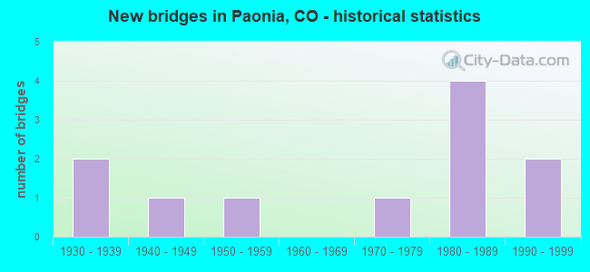
- New bridges - historical statistics
- 21930-1939
- 11940-1949
- 11950-1959
- 11970-1979
- 41980-1989
- 21990-1999


- Bridge Condition - Deck
- 12.5%Very good
- 37.5%Good
- 50.0%Satisfactory

- Bridge Condition - Superstructure
- 62.5%Good
- 37.5%Satisfactory

- Bridge Condition - Substructure
- 37.5%Good
- 50.0%Satisfactory
- 12.5%Fair

- Bridge Condition - Channel
- 11.1%Good
- 66.7%Satisfactory
- 22.2%Fair

- Bridge Condition - Culverts
- 33.3%Good
- 66.7%Satisfactory
Find on map >> Show street view
Structure Number: DEL4010D16.1-65, Location: .6 MI N OF SH 133 (Lat: 38.887139, Lng: -107.594972), Route carried "on" structure: County highway , Year Built: 1981, Status: Open, Structure Length: 1.10m (3.61ft), Average Daily Traffic: 215 (year 2018), Truck Traffic: 2%, Average Future Daily Traffic: 314 (year 2038), Features Intersected: FIRE MOUNTAIN CANAL, Facility Carried by Structure: COUNTY ROAD 4065
Minimum Vertical Clearance: 30+ m (98+ ft), Kilometerpoint: 0.985, Lanes on structure: 2, Owner: County Highway Agency, Approaching Roadway Width: 7.6m (24.9ft), Skew: 4 degrees, Material/Design: Concrete, Design/Construction: Tee Beam, Number Of Spans In Main Unit: 1, Length of Maximum Span: 10.1m (33.1ft), Curb-To-Curb Width: 8.5m (27.9ft), Out-to-Out Width: 9.1m (29.9ft)
Condition: Deck: Good, Superstructure: Good, Substructure: Satisfactory, Channel: Satisfactory, Operating Rating: 36.3 metric tons, Method Used To Determine Operating Rating: Field evaluation and documented engineering judgment, Inventory Rating: 32.7 metric tons, Method Used To Determine Inventory Rating: Field evaluation and documented engineering judgment, Structural Evaluation: Equal to present minimum criteria, Deck Geometry: Equal to present minimum criteria, Waterway Adequacy: Equal to present desirable criteria, Approach Roadway Alignment: Equal to present desirable criteria, Designated Inspection Frequency: Every 24 months, Inspection Date: September 2021, Deck Structure Type: Concrete Cast-file-Place, Wearing Surface/Protective System: Wearing Surface: Bituminous
Find on map >> Show street view
Structure Number: DEL4110D-0.156A, Location: .1 MI EAST OF OAK ST (Lat: 38.873972, Lng: -107.589000), Route carried "on" structure: County highway , Year Built: 1988, Status: Open, Structure Length: 1.15m (3.77ft), Average Daily Traffic: 389 (year 2018), Truck Traffic: 2%, Average Future Daily Traffic: 569 (year 2038), Features Intersected: MINNESOTA CREEK, Facility Carried by Structure: COUNTY ROAD 4110
Minimum Vertical Clearance: 30+ m (98+ ft), Kilometerpoint: 0.089, Lanes on structure: 2, Owner: County Highway Agency, Approaching Roadway Width: 7.0m (23.0ft), Skew: 2 degrees, Material/Design: Steel, Design/Construction: Stringer/Multi-beam, Number Of Spans In Main Unit: 1, Length of Maximum Span: 10.1m (33.1ft), Curb or Sidewalk Widths: Left: 0.0m, Right: 1.2m (3.9ft), Curb-To-Curb Width: 7.9m (25.9ft), Out-to-Out Width: 9.9m (32.5ft)
Condition: Deck: Satisfactory, Superstructure: Good, Substructure: Good, Channel: Fair, Operating Rating: 59.1 metric tons, Method Used To Determine Operating Rating: Load Factor (LF), Inventory Rating: 35.4 metric tons, Method Used To Determine Inventory Rating: Load Factor (LF), Structural Evaluation: Better than present minimum criteria, Deck Geometry: Somewhat better than minimum adequacy, Waterway Adequacy: Equal to present desirable criteria, Approach Roadway Alignment: Equal to present minimum criteria, Designated Inspection Frequency: Every 24 months, Inspection Date: September 2021, Deck Structure Type: Concrete Cast-file-Place, Wearing Surface/Protective System: Wearing Surface: Bituminous, Deck Protection: Epoxy Coated Reinforcing
Find on map >> Show street view
Structure Number: DEL4175D-0.2-57, Location: 1.6 MI NE OF PAONIA (Lat: 38.885667, Lng: -107.581611), Route carried "on" structure: County highway , Year Built: 1930, Status: Posted for load, Structure Length: 3.86m (12.66ft), Average Daily Traffic: 315 (year 2018), Truck Traffic: 2%, Average Future Daily Traffic: 460 (year 2038), Features Intersected: NORTH FORK GUNNISON RVR, Facility Carried by Structure: CR 4110
Minimum Vertical Clearance: 3.91m (12.83ft), Kilometerpoint: 2.024, Lanes on structure: 1, Owner: County Highway Agency, Approaching Roadway Width: 6.1m (20.0ft), Material/Design: Steel, Design/Construction: Truss - Thru, Number Of Spans In Main Unit: 1, Length of Maximum Span: 35.8m (117.5ft), Curb-To-Curb Width: 4.7m (15.4ft), Out-to-Out Width: 4.9m (16.1ft)
Condition: Deck: Satisfactory, Superstructure: Satisfactory, Substructure: Satisfactory, Channel: Satisfactory, Operating Rating: 16.2 metric tons, Method Used To Determine Operating Rating: Load Factor (LF), Inventory Rating: 9.7 metric tons, Method Used To Determine Inventory Rating: Load Factor (LF), Structural Evaluation: High priority of replacement, Deck Geometry: High priority of replacement, Waterway Adequacy: Equal to present desirable criteria, Approach Roadway Alignment: Somewhat better than minimum adequacy, Bridge Posting: Required (Relationship of Operating Rating to Maximum Legal Load: > 39.9% below), Length Of Structure Improvement: 4.88m (16.01ft), Designated Inspection Frequency: Every 24 months, Critical Feature Inspection Frequency: Every 24 months, Other Special Inspection Frequency: Every 60 months, Inspection Date: September 2021, Critical Feature Inspection Date: September 2021, Other Special Inspection Date: June 2021, Bridge Improvement Cost: $963,000, Roadway Improvement Cost: $96,000, Total Project Cost: $1,467,000 ( Estimate for 2019), Deck Structure Type: Wood or Timber, Wearing Surface/Protective System: Wearing Surface: Wood or Timber
Find on map >> Show street view
Structure Number: DEL4175D16.1-62, Location: .1 MI S OF SH 133 (Lat: 38.885000, Lng: -107.586472), Route carried "on" structure: County highway , Year Built: 1979, Status: Open, Structure Length: 0.80m (2.62ft), Average Daily Traffic: 300 (year 2018), Truck Traffic: 2%, Average Future Daily Traffic: 439 (year 2038), Features Intersected: GRAVEL ROAD, Facility Carried by Structure: COUNTY ROAD 4175
Minimum Vertical Clearance: 30+ m (98+ ft), Kilometerpoint: 2.532, Lanes on structure: 2, Owner: County Highway Agency, Approaching Roadway Width: 7.6m (24.9ft), Skew: 1 degrees, Material/Design: Steel, Design/Construction: Culvert, Number Of Spans In Main Unit: 1, Length of Maximum Span: 8.0m (26.2ft), Out-to-Out Width: 37.5m (123.0ft)
Condition: Culverts: Good, Structural Evaluation: Better than present minimum criteria, Approach Roadway Alignment: Equal to present minimum criteria, Designated Inspection Frequency: Every 24 months, Inspection Date: September 2021
Find on map >> Show street view
Structure Number: DELO.90-41.3-66, Location: W ENTRANCE TO PAONIA (Lat: 38.869139, Lng: -107.603722), Route carried "on" structure: City street , Year Built: 1984, Status: Open, Structure Length: 7.06m (23.16ft), Average Daily Traffic: 4,082 (year 2018), Truck Traffic: 2%, Average Future Daily Traffic: 5,959 (year 2038), Design Load: HS 20, Features Intersected: NORTH FORK GUNNISON RVR, Facility Carried by Structure: COUNTY ROAD O.90
Minimum Vertical Clearance: 30+ m (98+ ft), Kilometerpoint: 0.673, Lanes on structure: 2, Owner: City or Municipal Highway Agency, Approaching Roadway Width: 9.1m (29.9ft), Skew: 4 degrees, Material/Design: Prestressed concrete continuous, Design/Construction: Stringer/Multi-beam, Number Of Spans In Main Unit: 2, Length of Maximum Span: 33.2m (108.9ft), Curb or Sidewalk Widths: Left: 0.9m (3.0ft), Right: 0.0m, Curb-To-Curb Width: 7.3m (24.0ft), Out-to-Out Width: 9.1m (29.9ft)
Condition: Deck: Good, Superstructure: Good, Substructure: Fair, Channel: Fair, Operating Rating: 46.3 metric tons, Method Used To Determine Operating Rating: Load Factor (LF), Inventory Rating: 22.4 metric tons, Method Used To Determine Inventory Rating: Load Factor (LF), Structural Evaluation: Somewhat better than minimum adequacy, Deck Geometry: High priority of replacement, Waterway Adequacy: Equal to present desirable criteria, Approach Roadway Alignment: Better than present minimum criteria, Length Of Structure Improvement: 7.04m (23.10ft), Designated Inspection Frequency: Every 24 months, Inspection Date: September 2021, Bridge Improvement Cost: $1,241,000, Roadway Improvement Cost: $124,000, Total Project Cost: $1,365,000 ( Estimate for 2019), Deck Structure Type: Concrete Cast-file-Place, Wearing Surface/Protective System: Wearing Surface: Bituminous, Membrane: Built-up
Find on map >> Show street view
Structure Number: DELO35D-0.6-22A, Location: .6 MI NW OF SH 133 (Lat: 38.864611, Lng: -107.631278), Route carried "on" structure: County highway , Year Built: 1983, Status: Open, Structure Length: 0.62m (2.03ft), Average Daily Traffic: 151 (year 2018), Truck Traffic: 2%, Average Future Daily Traffic: 221 (year 2038), Features Intersected: FIRE MOUNTAIN CANAL, Facility Carried by Structure: STUCKER MESA ROAD
Minimum Vertical Clearance: 30+ m (98+ ft), Kilometerpoint: 5.475, Lanes on structure: 2, Owner: County Highway Agency, Approaching Roadway Width: 6.1m (20.0ft), Skew: 5 degrees, Material/Design: Concrete, Design/Construction: Culvert, Number Of Spans In Main Unit: 1, Length of Maximum Span: 6.2m (20.3ft), Curb-To-Curb Width: 6.1m (20.0ft), Out-to-Out Width: 6.7m (22.0ft)
Condition: Channel: Good, Culverts: Satisfactory, Operating Rating: 36.3 metric tons, Method Used To Determine Operating Rating: Field evaluation and documented engineering judgment, Inventory Rating: 32.7 metric tons, Method Used To Determine Inventory Rating: Field evaluation and documented engineering judgment, Structural Evaluation: Equal to present minimum criteria, Deck Geometry: Meets minimum limits, Waterway Adequacy: Equal to present desirable criteria, Approach Roadway Alignment: Equal to present minimum criteria, Designated Inspection Frequency: Every 24 months, Inspection Date: September 2021
Find on map >> Show street view
Structure Number: DELP00R-0.1-67A, Location: 1.1 MI NW OF SH 133 (Lat: 38.872056, Lng: -107.626917), Route carried "on" structure: County highway , Year Built: 1997, Status: Open, Structure Length: 0.99m (3.25ft), Average Daily Traffic: 93 (year 2018), Truck Traffic: 2%, Average Future Daily Traffic: 136 (year 2038), Design Load: HS 20, Features Intersected: FIRE MOUNTAIN CANAL, Facility Carried by Structure: COUNTY ROAD P.00/
Minimum Vertical Clearance: 30+ m (98+ ft), Kilometerpoint: 0.037, Lanes on structure: 2, Owner: County Highway Agency, Approaching Roadway Width: 7.3m (24.0ft), Skew: 2 degrees, Material/Design: Prestressed concrete, Design/Construction: Slab, Number Of Spans In Main Unit: 1, Length of Maximum Span: 8.2m (26.9ft), Curb-To-Curb Width: 8.6m (28.2ft), Out-to-Out Width: 9.4m (30.8ft)
Condition: Deck: Good, Superstructure: Good, Substructure: Good, Channel: Satisfactory, Operating Rating: 60.3 metric tons, Method Used To Determine Operating Rating: Load Factor (LF), Inventory Rating: 37.5 metric tons, Method Used To Determine Inventory Rating: Load Factor (LF), Structural Evaluation: Better than present minimum criteria, Deck Geometry: Better than present minimum criteria, Waterway Adequacy: Equal to present desirable criteria, Approach Roadway Alignment: Equal to present minimum criteria, Designated Inspection Frequency: Every 24 months, Inspection Date: September 2021, Deck Structure Type: Other, Wearing Surface/Protective System: Wearing Surface: Bituminous, Membrane: Built-up
Find on map >> Show street view
Structure Number: I-06-C, Location: 0.4 MI S OF JCT SH 133 (Lat: 38.873889, Lng: -107.597667), Route carried "on" structure: County highway , Year Built: 1955, Status: Open, Structure Length: 7.08m (23.23ft), Average Daily Traffic: 2,073 (year 2018), Truck Traffic: 7%, Average Future Daily Traffic: 3,026 (year 2038), Design Load: H 20, Features Intersected: NORTH FORK GUNNISON RVR, Facility Carried by Structure: Grand Avenue
Minimum Vertical Clearance: 30+ m (98+ ft), Kilometerpoint: 0.418, Lanes on structure: 2, Owner: County Highway Agency, Approaching Roadway Width: 8.5m (27.9ft), Skew: 3 degrees, Material/Design: Steel continuous, Design/Construction: Stringer/Multi-beam, Number Of Spans In Main Unit: 4, Length of Maximum Span: 18.6m (61.0ft), Curb or Sidewalk Widths: Left: 0.9m (3.0ft), Right: 0.9m (3.0ft), Curb-To-Curb Width: 8.5m (27.9ft), Out-to-Out Width: 10.4m (34.1ft)
Condition: Deck: Satisfactory, Superstructure: Satisfactory, Substructure: Satisfactory, Channel: Satisfactory, Operating Rating: 31.8 metric tons, Method Used To Determine Operating Rating: Load Factor (LF), Inventory Rating: 19.1 metric tons, Method Used To Determine Inventory Rating: Load Factor (LF), Structural Evaluation: Somewhat better than minimum adequacy, Deck Geometry: Meets minimum limits, Waterway Adequacy: Equal to present desirable criteria, Approach Roadway Alignment: Equal to present desirable criteria, Designated Inspection Frequency: Every 24 months, Inspection Date: September 2021, Deck Structure Type: Concrete Cast-file-Place, Wearing Surface/Protective System: Wearing Surface: Bituminous
Find on map >> Show street view
Structure Number: I-06-M, Location: ORIG 133 NEAR BOWIE (Lat: 38.917439, Lng: -107.549542), Route carried "on" structure: ServiceState highway 133B, Year Built: 1937, Status: Open, Structure Length: 1.25m (4.10ft), Average Daily Traffic: 10 (year 2020), Truck Traffic: 16%, Average Future Daily Traffic: 17 (year 2040), Design Load: H 15, Features Intersected: HUBBARD CREEK, Facility Carried by Structure: SH 133 FRONTAGE RD
Minimum Vertical Clearance: 30+ m (98+ ft), Kilometerpoint: 0.837, Lanes on structure: 2, Owner: State Highway Agency, Approaching Roadway Width: 6.1m (20.0ft), Material/Design: Steel, Design/Construction: Stringer/Multi-beam, Number Of Spans In Main Unit: 1, Length of Maximum Span: 11.9m (39.0ft), Curb-To-Curb Width: 7.2m (23.6ft), Out-to-Out Width: 7.3m (24.0ft)
Condition: Deck: Satisfactory, Superstructure: Satisfactory, Substructure: Satisfactory, Channel: Satisfactory, Operating Rating: 34.3 metric tons, Method Used To Determine Operating Rating: Load Factor (LF), Inventory Rating: 20.5 metric tons, Method Used To Determine Inventory Rating: Load Factor (LF), Structural Evaluation: Somewhat better than minimum adequacy, Deck Geometry: Somewhat better than minimum adequacy, Waterway Adequacy: Equal to present minimum criteria, Approach Roadway Alignment: Equal to present desirable criteria, Designated Inspection Frequency: Every 24 months, Inspection Date: January 2021, Deck Structure Type: Corrugated Steel, Wearing Surface/Protective System: Wearing Surface: Bituminous
Find on map >> Show street view
Structure Number: I-06-O, Location: 3.5 MI. NE. OF PAONIA (Lat: 38.913131, Lng: -107.550833), Route carried "on" structure: State highway 133A, Year Built: 1991, Status: Open, Structure Length: 5.11m (16.77ft), Average Daily Traffic: 1,500 (year 2020), Truck Traffic: 6%, Average Future Daily Traffic: 1,515 (year 2040), Design Load: HS 20+Mod, Features Intersected: UP RR, Facility Carried by Structure: SH 133 ML
Minimum Vertical Clearance: 30+ m (98+ ft), Kilometerpoint: 19.948, Lanes on structure: 2, Base Highway Network: Yes, Owner: State Highway Agency, Approaching Roadway Width: 12.2m (40.0ft), Skew: 1 degrees, Material/Design: Steel continuous, Design/Construction: Stringer/Multi-beam, Number Of Spans In Main Unit: 3, Length of Maximum Span: 21.6m (70.9ft), Curb-To-Curb Width: 12.2m (40.0ft), Out-to-Out Width: 13.0m (42.7ft)
Condition: Deck: Very good, Superstructure: Good, Substructure: Good, Operating Rating: 61.7 metric tons, Method Used To Determine Operating Rating: Load Factor (LF), Inventory Rating: 37.2 metric tons, Method Used To Determine Inventory Rating: Load Factor (LF), Structural Evaluation: Better than present minimum criteria, Deck Geometry: Better than present minimum criteria, Underclear: Superior to present desirable criteria, Approach Roadway Alignment: Equal to present desirable criteria, Designated Inspection Frequency: Every 48 months, Inspection Date: October 2018, Deck Structure Type: Concrete Cast-file-Place, Wearing Surface/Protective System: Wearing Surface: Bituminous, Membrane: Preformed Fabric, Deck Protection: Epoxy Coated Reinforcing
Find on map >> Show street view
Structure Number: I-06-R, Location: 2 MI SW OF PAONIA EXIT (Lat: 38.862122, Lng: -107.621806), Route carried "on" structure: State highway 133A, Year Built: 1949, Status: Open, Structure Length: 0.90m (2.95ft), Average Daily Traffic: 3,400 (year 2020), Truck Traffic: 3%, Average Future Daily Traffic: 3,638 (year 2040), Design Load: H 20, Features Intersected: ROOTCAP CREEK, Facility Carried by Structure: SH 133 ML
Minimum Vertical Clearance: 30+ m (98+ ft), Kilometerpoint: 11.307, Lanes on structure: 2, Base Highway Network: Yes, Owner: State Highway Agency, Approaching Roadway Width: 7.3m (24.0ft), Skew: 4 degrees, Material/Design: Concrete, Design/Construction: Culvert, Number Of Spans In Main Unit: 2, Length of Maximum Span: 4.3m (14.1ft), Curb-To-Curb Width: 9.3m (30.5ft), Out-to-Out Width: 9.9m (32.5ft)
Condition: Channel: Satisfactory, Culverts: Satisfactory, Operating Rating: 36.3 metric tons, Method Used To Determine Operating Rating: Field evaluation and documented engineering judgment, Inventory Rating: 32.7 metric tons, Method Used To Determine Inventory Rating: Field evaluation and documented engineering judgment, Structural Evaluation: Equal to present minimum criteria, Deck Geometry: Meets minimum limits, Waterway Adequacy: Superior to present desirable criteria, Approach Roadway Alignment: Equal to present desirable criteria, Designated Inspection Frequency: Every 24 months, Inspection Date: January 2021