Bridge Statistics for Pana, Illinois (IL)
Condition, Traffic, Stress, Structural Evaluation, Project Costs
- National Bridge Inventory (NBI) Statistics
- 38Number of bridges
- 197ft / 59.5mTotal length
- $772,000Total costs
- 36,390Total average daily traffic
- 4,409Total average daily truck traffic
- 42,517Total future (year 2032) average daily traffic
- National Bridge Inventory (NBI) Registered Bridges for Pana
- No street view available for this location
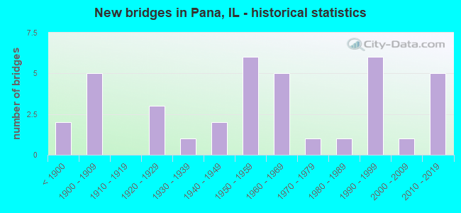
- New bridges - historical statistics
- 2Before 1900
- 51900-1909
- 31920-1929
- 11930-1939
- 21940-1949
- 61950-1959
- 51960-1969
- 11970-1979
- 11980-1989
- 61990-1999
- 12000-2009
- 52010-2019

- Reconstructed bridges - Historical Statistics
- 11940-1949
- 31950-1959
- 11960-1969
- 21970-1979


- Bridge Condition - Deck
- 10.3%Very good
- 48.3%Good
- 31.0%Satisfactory
- 6.9%Fair
- 3.4%Poor

- Bridge Condition - Superstructure
- 10.3%Very good
- 27.6%Good
- 31.0%Satisfactory
- 20.7%Fair
- 6.9%Poor
- 3.4%Serious

- Bridge Condition - Substructure
- 17.2%Very good
- 6.9%Good
- 13.8%Satisfactory
- 48.3%Fair
- 13.8%Poor

- Bridge Condition - Channel
- 2.6%Excellent
- 7.9%Very good
- 23.7%Good
- 13.2%Satisfactory
- 39.5%Fair
- 13.2%Poor

- Bridge Condition - Culverts
- 33.3%Very good
- 22.2%Good
- 11.1%Satisfactory
- 11.1%Fair
- 22.2%Poor
Find on map >> Show street view
Structure Number: 110006, Location: .2M W US 51 - E PANA (Lat: 39.388711, Lng: -89.048958), Route carried "on" structure: US 51, Year Built: 1923, Year Reconstructed: 1966, Status: Open, Structure Length: 0.74m (2.43ft), Average Daily Traffic: 6,750 (year 2021), Truck Traffic: 11%, Average Future Daily Traffic: 7,265 (year 2032), Design Load: HS 20, Features Intersected: BECKS CR. TRIB.
Minimum Vertical Clearance: 30+ m (98+ ft), Kilometerpoint: 289.272, Lanes on structure: 2, Base Highway Network: Yes, Owner: State Highway Agency, Approaching Roadway Width: 12.8m (42.0ft), Material/Design: Concrete, Design/Construction: Slab, Number Of Spans In Main Unit: 1, Length of Maximum Span: 6.9m (22.6ft), Curb-To-Curb Width: 13.4m (44.0ft), Out-to-Out Width: 14.2m (46.6ft)
Condition: Deck: Satisfactory, Superstructure: Good, Substructure: Good, Channel: Satisfactory, Operating Rating: 59.9 metric tons, Method Used To Determine Operating Rating: Load Factor (LF) rating reported by rating factor (RF) method using MS18 loading, Inventory Rating: 35.6 metric tons, Method Used To Determine Inventory Rating: Load Factor (LF) rating reported by rating factor (RF) method using MS18 loading, Structural Evaluation: Better than present minimum criteria, Deck Geometry: Equal to present minimum criteria, Waterway Adequacy: Superior to present desirable criteria, Approach Roadway Alignment: Equal to present desirable criteria, Designated Inspection Frequency: Every 24 months, Inspection Date: January 2022, Deck Structure Type: Concrete Cast-file-Place, Wearing Surface/Protective System: Wearing Surface: Integral Concrete, Membrane: Built-up
Find on map >> Show street view
Structure Number: 110013, Location: 2.5M NW WASH ST BEND (Lat: 39.420158, Lng: -89.122514), Route carried "on" structure: State highway 29, Year Built: 1924, Year Reconstructed: 1958, Status: Open, Structure Length: 1.31m (4.30ft), Average Daily Traffic: 4,300 (year 2021), Truck Traffic: 11%, Average Future Daily Traffic: 4,108 (year 2032), Design Load: HS 20, Features Intersected: MAIN DRAINAGE DITCH
Minimum Vertical Clearance: 30+ m (98+ ft), Kilometerpoint: 5.954, Lanes on structure: 2, Base Highway Network: Yes, Owner: State Highway Agency, Approaching Roadway Width: 13.4m (44.0ft), Material/Design: Concrete continuous, Design/Construction: Slab, Number Of Spans In Main Unit: 2, Length of Maximum Span: 6.4m (21.0ft), Curb-To-Curb Width: 13.2m (43.3ft), Out-to-Out Width: 14.1m (46.3ft)
Condition: Deck: Poor, Superstructure: Fair, Substructure: Fair, Channel: Good, Operating Rating: 49.6 metric tons, Method Used To Determine Operating Rating: Allowable Stress (AS) rating reported by rating factor (RF) method using MS18 loading, Inventory Rating: 32.4 metric tons, Method Used To Determine Inventory Rating: Allowable Stress (AS) rating reported by rating factor (RF) method using MS18 loading, Structural Evaluation: Somewhat better than minimum adequacy, Deck Geometry: Equal to present minimum criteria, Waterway Adequacy: Superior to present desirable criteria, Approach Roadway Alignment: Equal to present desirable criteria, Designated Inspection Frequency: Every 24 months, Inspection Date: August 2021, Deck Structure Type: Concrete Cast-file-Place, Wearing Surface/Protective System: Wearing Surface: Other, Deck Protection: Bituminous
Find on map >> Show street view
Structure Number: 110039, Location: 1 MI S OF PANA (Lat: 39.362878, Lng: -89.081753), Route carried "on" structure: US 51, Year Built: 1997, Status: Open, Structure Length: 1.80m (5.91ft), Average Daily Traffic: 3,850 (year 2021), Truck Traffic: 18%, Average Future Daily Traffic: 4,108 (year 2032), Design Load: HS 20+Mod, Features Intersected: SEWER CREEK
Minimum Vertical Clearance: 30+ m (98+ ft), Kilometerpoint: 283.414, Lanes on structure: 2, Base Highway Network: Yes, Owner: State Highway Agency, Approaching Roadway Width: 7.3m (24.0ft), Material/Design: Steel, Design/Construction: Stringer/Multi-beam, Number Of Spans In Main Unit: 1, Length of Maximum Span: 17.2m (56.4ft), Curb-To-Curb Width: 9.6m (31.5ft), Out-to-Out Width: 10.6m (34.8ft)
Condition: Deck: Satisfactory, Superstructure: Very good, Substructure: Very good, Channel: Good, Operating Rating: 84.9 metric tons, Method Used To Determine Operating Rating: Load Factor (LF) rating reported by rating factor (RF) method using MS18 loading, Inventory Rating: 50.9 metric tons, Method Used To Determine Inventory Rating: Load Factor (LF) rating reported by rating factor (RF) method using MS18 loading, Structural Evaluation: Equal to present desirable criteria, Deck Geometry: Meets minimum limits, Waterway Adequacy: Equal to present desirable criteria, Approach Roadway Alignment: Equal to present desirable criteria, Designated Inspection Frequency: Every 48 months, Inspection Date: January 2021, Deck Structure Type: Concrete Cast-file-Place, Wearing Surface/Protective System: Deck Protection: Epoxy Coated Reinforcing
Find on map >> Show street view
Structure Number: 112015, Location: 1.5 MI S OF PANA (Lat: 39.355919, Lng: -89.081781), Route carried "on" structure: US 51, Year Built: 1995, Status: Open, Structure Length: 0.73m (2.40ft), Average Daily Traffic: 3,800 (year 2021), Truck Traffic: 14%, Average Future Daily Traffic: 3,808 (year 2032), Design Load: HS 20+Mod, Features Intersected: TRIB TO COAL CREEK
Minimum Vertical Clearance: 30+ m (98+ ft), Kilometerpoint: 282.641, Lanes on structure: 2, Base Highway Network: Yes, Owner: State Highway Agency, Approaching Roadway Width: 11.6m (38.1ft), Skew: 4 degrees, Material/Design: Concrete, Design/Construction: Culvert, Number Of Spans In Main Unit: 2, Length of Maximum Span: 4.3m (14.1ft)
Condition: Channel: Good, Culverts: Good, Operating Rating: 74.2 metric tons, Method Used To Determine Operating Rating: Load Factor (LF) rating reported by rating factor (RF) method using MS18 loading, Inventory Rating: 44.4 metric tons, Method Used To Determine Inventory Rating: Load Factor (LF) rating reported by rating factor (RF) method using MS18 loading, Structural Evaluation: Better than present minimum criteria, Waterway Adequacy: Better than present minimum criteria, Approach Roadway Alignment: Equal to present desirable criteria, Designated Inspection Frequency: Every 48 months, Inspection Date: January 2019
Find on map >> Show street view
Structure Number: 112142, Location: 0.9 mi N IL 16 (Lat: 39.401797, Lng: -89.044164), Route carried "on" structure: US 51, Year Built: 2019, Status: Open, Structure Length: 1.08m (3.54ft), Average Daily Traffic: 3,800 (year 2021), Truck Traffic: 12%, Average Future Daily Traffic: 4,095 (year 2038), Features Intersected: Ditch
Minimum Vertical Clearance: 30+ m (98+ ft), Kilometerpoint: 291.122, Lanes on structure: 2, Base Highway Network: Yes, Owner: State Highway Agency, Approaching Roadway Width: 12.2m (40.0ft), Material/Design: Concrete, Design/Construction: Culvert, Number Of Spans In Main Unit: 3, Length of Maximum Span: 0.0m, Curb-To-Curb Width: 12.2m (40.0ft)
Condition: Channel: Excellent, Culverts: Very good, Operating Rating: 67.1 metric tons, Method Used To Determine Operating Rating: Load and Resistance Factor Rating (LRFR) rating reported by rating factor(RF) method using HL-93 loadings, Inventory Rating: 51.8 metric tons, Method Used To Determine Inventory Rating: Load and Resistance Factor Rating (LRFR) rating reported by rating factor(RF) method using HL-93 loadings, Structural Evaluation: Equal to present desirable criteria, Deck Geometry: Equal to present minimum criteria, Waterway Adequacy: Equal to present desirable criteria, Approach Roadway Alignment: Superior to present desirable criteria, Designated Inspection Frequency: Every 48 months, Inspection Date: October 2021
Find on map >> Show street view
Structure Number: 112504, Location: 3M N IL 16 (Lat: 39.436808, Lng: -89.045008), Route carried "on" structure: US 51, Year Built: 2013, Status: Open, Structure Length: 0.73m (2.40ft), Average Daily Traffic: 3,700 (year 2021), Truck Traffic: 13%, Average Future Daily Traffic: 5,812 (year 2032), Design Load: HS 20+Mod, Features Intersected: DRAINAGE DITCH
Minimum Vertical Clearance: 30+ m (98+ ft), Kilometerpoint: 295.017, Lanes on structure: 2, Base Highway Network: Yes, Owner: State Highway Agency, Approaching Roadway Width: 12.8m (42.0ft), Skew: 3 degrees, Material/Design: Concrete, Design/Construction: Culvert, Number Of Spans In Main Unit: 2, Length of Maximum Span: 3.5m (11.5ft)
Condition: Channel: Very good, Culverts: Very good, Operating Rating: 89.1 metric tons, Method Used To Determine Operating Rating: Load Factor (LF) rating reported by rating factor (RF) method using MS18 loading, Inventory Rating: 57.7 metric tons, Method Used To Determine Inventory Rating: Load Factor (LF) rating reported by rating factor (RF) method using MS18 loading, Structural Evaluation: Equal to present desirable criteria, Waterway Adequacy: Superior to present desirable criteria, Approach Roadway Alignment: Equal to present desirable criteria, Designated Inspection Frequency: Every 48 months, Inspection Date: November 2019
Find on map >> Show street view
Structure Number: 113034, Location: 1MI SE OF PANA (Lat: 39.379258, Lng: -89.044250), Route carried "on" structure: County highway , Year Built: 1939, Year Reconstructed: 1975, Status: Posted for load, Structure Length: 0.81m (2.66ft), Average Daily Traffic: 450 (year 2021), Truck Traffic: 4%, Average Future Daily Traffic: 601 (year 2032), Features Intersected: BECK'S CREEK, Facility Carried by Structure: TR 302
Minimum Vertical Clearance: 30+ m (98+ ft), Kilometerpoint: 0.805, Lanes on structure: 2, Owner: Town or Township Highway Agency, Approaching Roadway Width: 6.1m (20.0ft), Material/Design: Steel continuous, Design/Construction: Stringer/Multi-beam, Number Of Spans In Main Unit: 2, Length of Maximum Span: 4.0m (13.1ft), Curb-To-Curb Width: 7.8m (25.6ft), Out-to-Out Width: 8.4m (27.6ft)
Condition: Deck: Good, Superstructure: Serious, Substructure: Poor, Channel: Fair, Operating Rating: 6.2 metric tons, Method Used To Determine Operating Rating: Load Factor (LF) rating reported by rating factor (RF) method using MS18 loading, Inventory Rating: 3.2 metric tons, Method Used To Determine Inventory Rating: Load Factor (LF) rating reported by rating factor (RF) method using MS18 loading, Structural Evaluation: High priority of replacement, Deck Geometry: Meets minimum limits, Waterway Adequacy: Equal to present minimum criteria, Approach Roadway Alignment: Equal to present desirable criteria, Bridge Posting: Required (Relationship of Operating Rating to Maximum Legal Load: > 39.9% below), Length Of Structure Improvement: 1.49m (4.89ft), Designated Inspection Frequency: Every 24 months, Critical Feature Inspection Frequency: Every 12 months, Inspection Date: December 2020, Critical Feature Inspection Date: December 2020, Bridge Improvement Cost: $66,000, Roadway Improvement Cost: $7,000, Total Project Cost: $99,000, Deck Structure Type: Concrete Cast-file-Place, Wearing Surface/Protective System: Wearing Surface: Gravel
Find on map >> Show street view
Structure Number: 113203, Location: 2MI NW PANA (Lat: 39.422864, Lng: -89.118014), Route carried "on" structure: County highway , Year Built: 1898, Status: Posted for load, Structure Length: 1.07m (3.51ft), Average Daily Traffic: 10 (year 2021), Truck Traffic: 10%, Average Future Daily Traffic: 59 (year 2032), Features Intersected: LAKE FORK, Facility Carried by Structure: TR 258
Minimum Vertical Clearance: 30+ m (98+ ft), Kilometerpoint: 1.464, Lanes on structure: 1, Owner: Town or Township Highway Agency, Approaching Roadway Width: 5.8m (19.0ft), Material/Design: Steel, Design/Construction: Truss - Thru, Number Of Spans In Main Unit: 1, Length of Maximum Span: 10.4m (34.1ft), Curb-To-Curb Width: 4.8m (15.7ft), Out-to-Out Width: 4.8m (15.7ft)
Condition: Deck: Very good, Superstructure: Poor, Substructure: Fair, Channel: Fair, Operating Rating: 9.7 metric tons, Method Used To Determine Operating Rating: Load Factor (LF) rating reported by rating factor (RF) method using MS18 loading, Inventory Rating: 5.8 metric tons, Method Used To Determine Inventory Rating: Load Factor (LF) rating reported by rating factor (RF) method using MS18 loading, Structural Evaluation: High priority of replacement, Deck Geometry: Equal to present desirable criteria, Waterway Adequacy: Equal to present minimum criteria, Approach Roadway Alignment: Equal to present minimum criteria, Bridge Posting: Required (Relationship of Operating Rating to Maximum Legal Load: > 39.9% below), Length Of Structure Improvement: 1.71m (5.61ft), Designated Inspection Frequency: Every 24 months, Critical Feature Inspection Frequency: Every 12 months, Inspection Date: December 2019, Critical Feature Inspection Date: December 2020, Bridge Improvement Cost: $48,000, Roadway Improvement Cost: $5,000, Total Project Cost: $72,000, Deck Structure Type: Wood or Timber, Wearing Surface/Protective System: Wearing Surface: Other
Find on map >> Show street view
Structure Number: 113219, Location: 3.5MI N PANA (Lat: 39.450206, Lng: -89.073394), Route carried "on" structure: County highway , Year Built: 1950, Status: Open, Structure Length: 3.23m (10.60ft), Average Daily Traffic: 20 (year 2021), Truck Traffic: 5%, Average Future Daily Traffic: 25 (year 2032), Design Load: H 15, Features Intersected: LAKE FORK, Facility Carried by Structure: TR 273
Minimum Vertical Clearance: 30+ m (98+ ft), Kilometerpoint: 20.165, Lanes on structure: 2, Owner: Town or Township Highway Agency, Approaching Roadway Width: 4.9m (16.1ft), Skew: 4 degrees, Material/Design: Steel continuous, Design/Construction: Stringer/Multi-beam, Number Of Spans In Main Unit: 3, Length of Maximum Span: 11.9m (39.0ft), Curb-To-Curb Width: 6.2m (20.3ft), Out-to-Out Width: 6.7m (22.0ft)
Condition: Deck: Good, Superstructure: Satisfactory, Substructure: Fair, Channel: Fair, Operating Rating: 37.9 metric tons, Method Used To Determine Operating Rating: Load Factor (LF) rating reported by rating factor (RF) method using MS18 loading, Inventory Rating: 17.8 metric tons, Method Used To Determine Inventory Rating: Load Factor (LF) rating reported by rating factor (RF) method using MS18 loading, Structural Evaluation: Somewhat better than minimum adequacy, Deck Geometry: Somewhat better than minimum adequacy, Waterway Adequacy: Equal to present desirable criteria, Approach Roadway Alignment: Equal to present minimum criteria, Designated Inspection Frequency: Every 24 months, Inspection Date: December 2019, Deck Structure Type: Concrete Cast-file-Place
Find on map >> Show street view
Structure Number: 11322, Location: 3.5MI N PANA (Lat: 39.450186, Lng: -89.070144), Route carried "on" structure: County highway , Year Built: 1950, Status: Posted for load, Structure Length: 2.23m (7.32ft), Average Daily Traffic: 20 (year 2021), Truck Traffic: 5%, Average Future Daily Traffic: 25 (year 2032), Design Load: H 15, Features Intersected: S. FORK LAKE FORK, Facility Carried by Structure: TR 273
Minimum Vertical Clearance: 30+ m (98+ ft), Kilometerpoint: 20.454, Lanes on structure: 2, Owner: Town or Township Highway Agency, Approaching Roadway Width: 4.9m (16.1ft), Material/Design: Steel continuous, Design/Construction: Stringer/Multi-beam, Number Of Spans In Main Unit: 3, Length of Maximum Span: 8.2m (26.9ft), Curb-To-Curb Width: 6.1m (20.0ft), Out-to-Out Width: 6.7m (22.0ft)
Condition: Deck: Good, Superstructure: Satisfactory, Substructure: Fair, Channel: Fair, Operating Rating: 31.1 metric tons, Method Used To Determine Operating Rating: Allowable Stress (AS) rating reported by rating factor (RF) method using MS18 loading, Inventory Rating: 19.8 metric tons, Method Used To Determine Inventory Rating: Allowable Stress (AS) rating reported by rating factor (RF) method using MS18 loading, Structural Evaluation: Somewhat better than minimum adequacy, Deck Geometry: Somewhat better than minimum adequacy, Waterway Adequacy: Equal to present desirable criteria, Approach Roadway Alignment: Equal to present minimum criteria, Bridge Posting: Required (Relationship of Operating Rating to Maximum Legal Load: 20.0 - 29.9% below), Designated Inspection Frequency: Every 24 months, Inspection Date: December 2019, Deck Structure Type: Concrete Cast-file-Place
Find on map >> Show street view
Structure Number: 113229, Location: 3 MI N PANA (Lat: 39.443711, Lng: -89.082144), Route carried "on" structure: County highway , Year Built: 1927, Status: Open, Structure Length: 1.60m (5.25ft), Average Daily Traffic: 20 (year 2021), Truck Traffic: 20%, Average Future Daily Traffic: 100 (year 2032), Features Intersected: LAKE FORK, Facility Carried by Structure: TR 282A
Minimum Vertical Clearance: 30+ m (98+ ft), Kilometerpoint: 15.337, Lanes on structure: 2, Owner: Town or Township Highway Agency, Approaching Roadway Width: 7.6m (24.9ft), Material/Design: Steel, Design/Construction: Stringer/Multi-beam, Number Of Spans In Main Unit: 2, Length of Maximum Span: 7.9m (25.9ft), Curb-To-Curb Width: 7.4m (24.3ft), Out-to-Out Width: 7.4m (24.3ft)
Condition: Deck: Satisfactory, Superstructure: Fair, Substructure: Poor, Channel: Poor, Operating Rating: 36.6 metric tons, Method Used To Determine Operating Rating: Load Factor (LF) rating reported by rating factor (RF) method using MS18 loading, Inventory Rating: 21.7 metric tons, Method Used To Determine Inventory Rating: Load Factor (LF) rating reported by rating factor (RF) method using MS18 loading, Structural Evaluation: Meets minimum limits, Deck Geometry: Equal to present minimum criteria, Waterway Adequacy: Equal to present minimum criteria, Approach Roadway Alignment: Meets minimum limits, Length Of Structure Improvement: 1.62m (5.31ft), Designated Inspection Frequency: Every 24 months, Critical Feature Inspection Frequency: Every 24 months, Inspection Date: December 2019, Critical Feature Inspection Date: December 2019, Bridge Improvement Cost: $52,000, Roadway Improvement Cost: $5,000, Total Project Cost: $78,000, Deck Structure Type: Concrete Cast-file-Place, Wearing Surface/Protective System: Wearing Surface: Gravel
Find on map >> Show street view
Structure Number: 113232, Location: 3MI N PANA (Lat: 39.436139, Lng: -89.099819), Route carried "on" structure: County highway , Year Built: 1971, Status: Posted for load, Structure Length: 2.29m (7.51ft), Average Daily Traffic: 125 (year 2021), Truck Traffic: 9%, Average Future Daily Traffic: 175 (year 2032), Design Load: HS 15, Features Intersected: LAKE FORK, Facility Carried by Structure: TR 283
Minimum Vertical Clearance: 30+ m (98+ ft), Kilometerpoint: 9.785, Lanes on structure: 2, Owner: Town or Township Highway Agency, Approaching Roadway Width: 7.9m (25.9ft), Material/Design: Steel continuous, Design/Construction: Stringer/Multi-beam, Number Of Spans In Main Unit: 3, Length of Maximum Span: 7.9m (25.9ft), Curb-To-Curb Width: 7.5m (24.6ft), Out-to-Out Width: 8.5m (27.9ft)
Condition: Deck: Good, Superstructure: Good, Substructure: Fair, Channel: Poor, Operating Rating: 24.6 metric tons, Method Used To Determine Operating Rating: Load Factor (LF) rating reported by rating factor (RF) method using MS18 loading, Inventory Rating: 14.9 metric tons, Method Used To Determine Inventory Rating: Load Factor (LF) rating reported by rating factor (RF) method using MS18 loading, Structural Evaluation: Meets minimum limits, Deck Geometry: Somewhat better than minimum adequacy, Waterway Adequacy: Equal to present desirable criteria, Approach Roadway Alignment: Equal to present minimum criteria, Bridge Posting: Required (Relationship of Operating Rating to Maximum Legal Load: 20.0 - 29.9% below), Designated Inspection Frequency: Every 24 months, Inspection Date: December 2019, Deck Structure Type: Concrete Cast-file-Place, Wearing Surface/Protective System: Wearing Surface: Gravel
Find on map >> Show street view
Structure Number: 113233, Location: 3MI N PANA (Lat: 39.435533, Lng: -89.065078), Route carried "on" structure: County highway , Year Built: 1967, Status: Open, Structure Length: 2.07m (6.79ft), Average Daily Traffic: 20 (year 2021), Truck Traffic: 5%, Average Future Daily Traffic: 25 (year 2032), Features Intersected: S. FORK LAKE FORK, Facility Carried by Structure: TR 268
Minimum Vertical Clearance: 30+ m (98+ ft), Kilometerpoint: 2.961, Lanes on structure: 2, Owner: Town or Township Highway Agency, Approaching Roadway Width: 8.5m (27.9ft), Skew: 2 degrees, Material/Design: Steel continuous, Design/Construction: Stringer/Multi-beam, Number Of Spans In Main Unit: 3, Length of Maximum Span: 7.6m (24.9ft), Curb-To-Curb Width: 7.4m (24.3ft), Out-to-Out Width: 7.9m (25.9ft)
Condition: Deck: Good, Superstructure: Good, Substructure: Fair, Channel: Fair, Operating Rating: 42.1 metric tons, Method Used To Determine Operating Rating: Allowable Stress (AS) rating reported by rating factor (RF) method using MS18 loading, Inventory Rating: 27.5 metric tons, Method Used To Determine Inventory Rating: Allowable Stress (AS) rating reported by rating factor (RF) method using MS18 loading, Structural Evaluation: Somewhat better than minimum adequacy, Deck Geometry: Equal to present minimum criteria, Waterway Adequacy: Equal to present minimum criteria, Approach Roadway Alignment: Equal to present desirable criteria, Designated Inspection Frequency: Every 24 months, Inspection Date: December 2019, Deck Structure Type: Concrete Cast-file-Place
Find on map >> Show street view
Structure Number: 113235, Location: 2.5 MI NNE PANA (Lat: 39.430097, Lng: -89.061831), Route carried "on" structure: County highway , Year Built: 1950, Status: Open, Structure Length: 2.47m (8.10ft), Average Daily Traffic: 100 (year 2021), Truck Traffic: 2%, Average Future Daily Traffic: 276 (year 2032), Design Load: H 15, Features Intersected: S. FORK LAKE FORK, Facility Carried by Structure: TR 288
Minimum Vertical Clearance: 30+ m (98+ ft), Kilometerpoint: 0.612, Lanes on structure: 2, Owner: Town or Township Highway Agency, Approaching Roadway Width: 7.3m (24.0ft), Skew: 2 degrees, Material/Design: Steel continuous, Design/Construction: Stringer/Multi-beam, Number Of Spans In Main Unit: 3, Length of Maximum Span: 9.1m (29.9ft), Curb-To-Curb Width: 6.1m (20.0ft), Out-to-Out Width: 6.7m (22.0ft)
Condition: Deck: Fair, Superstructure: Satisfactory, Substructure: Fair, Channel: Poor, Operating Rating: 34.7 metric tons, Method Used To Determine Operating Rating: Allowable Stress (AS) rating reported by rating factor (RF) method using MS18 loading, Inventory Rating: 21.7 metric tons, Method Used To Determine Inventory Rating: Allowable Stress (AS) rating reported by rating factor (RF) method using MS18 loading, Structural Evaluation: Somewhat better than minimum adequacy, Deck Geometry: Somewhat better than minimum adequacy, Waterway Adequacy: Equal to present minimum criteria, Approach Roadway Alignment: Equal to present desirable criteria, Designated Inspection Frequency: Every 24 months, Inspection Date: December 2019, Deck Structure Type: Concrete Cast-file-Place, Wearing Surface/Protective System: Wearing Surface: Gravel
Find on map >> Show street view
Structure Number: 113238, Location: 4.4 MI NNE PANA (Lat: 39.455639, Lng: -89.063250), Route carried "on" structure: County highway , Year Built: 1957, Status: Open, Structure Length: 2.68m (8.79ft), Average Daily Traffic: 100 (year 2021), Average Future Daily Traffic: 175 (year 2032), Design Load: H 15, Features Intersected: LAKE FORK, Facility Carried by Structure: TR 290
Minimum Vertical Clearance: 30+ m (98+ ft), Kilometerpoint: 14.081, Lanes on structure: 2, Owner: Town or Township Highway Agency, Approaching Roadway Width: 6.7m (22.0ft), Material/Design: Steel continuous, Design/Construction: Stringer/Multi-beam, Number Of Spans In Main Unit: 3, Length of Maximum Span: 10.1m (33.1ft), Curb-To-Curb Width: 6.1m (20.0ft), Out-to-Out Width: 6.7m (22.0ft)
Condition: Deck: Good, Superstructure: Satisfactory, Substructure: Fair, Channel: Fair, Operating Rating: 37.6 metric tons, Method Used To Determine Operating Rating: Allowable Stress (AS) rating reported by rating factor (RF) method using MS18 loading, Inventory Rating: 23.3 metric tons, Method Used To Determine Inventory Rating: Allowable Stress (AS) rating reported by rating factor (RF) method using MS18 loading, Structural Evaluation: Somewhat better than minimum adequacy, Deck Geometry: Somewhat better than minimum adequacy, Waterway Adequacy: Equal to present desirable criteria, Approach Roadway Alignment: Equal to present minimum criteria, Designated Inspection Frequency: Every 24 months, Inspection Date: December 2019, Deck Structure Type: Concrete Cast-file-Place, Wearing Surface/Protective System: Wearing Surface: Gravel
Find on map >> Show street view
Structure Number: 113239, Location: 2MI NE PANA (Lat: 39.419117, Lng: -89.050575), Route carried "on" structure: County highway , Year Built: 1967, Status: Open, Structure Length: 1.92m (6.30ft), Average Daily Traffic: 20 (year 2021), Truck Traffic: 5%, Average Future Daily Traffic: 29 (year 2032), Features Intersected: S. FORK LAKE FORK, Facility Carried by Structure: TR 295
Minimum Vertical Clearance: 30+ m (98+ ft), Kilometerpoint: 1.014, Lanes on structure: 2, Owner: Town or Township Highway Agency, Approaching Roadway Width: 6.7m (22.0ft), Material/Design: Steel continuous, Design/Construction: Stringer/Multi-beam, Number Of Spans In Main Unit: 3, Length of Maximum Span: 7.0m (23.0ft), Curb-To-Curb Width: 7.4m (24.3ft), Out-to-Out Width: 8.1m (26.6ft)
Condition: Deck: Good, Superstructure: Good, Substructure: Fair, Channel: Good, Operating Rating: 40.2 metric tons, Method Used To Determine Operating Rating: Allowable Stress (AS) rating reported by rating factor (RF) method using MS18 loading, Inventory Rating: 27.5 metric tons, Method Used To Determine Inventory Rating: Allowable Stress (AS) rating reported by rating factor (RF) method using MS18 loading, Structural Evaluation: Somewhat better than minimum adequacy, Deck Geometry: Equal to present minimum criteria, Waterway Adequacy: Equal to present minimum criteria, Approach Roadway Alignment: Equal to present desirable criteria, Designated Inspection Frequency: Every 24 months, Inspection Date: December 2019, Deck Structure Type: Concrete Cast-file-Place, Wearing Surface/Protective System: Wearing Surface: Gravel
Find on map >> Show street view
Structure Number: 113242, Location: 2MI NW PANA (Lat: 39.413711, Lng: -89.131306), Route carried "on" structure: County highway , Year Built: 1900, Status: Posted for load, Structure Length: 0.79m (2.59ft), Average Daily Traffic: 20 (year 2021), Truck Traffic: 5%, Average Future Daily Traffic: 29 (year 2032), Features Intersected: LAKE FORK, Facility Carried by Structure: TR 303
Minimum Vertical Clearance: 30+ m (98+ ft), Kilometerpoint: 0.644, Lanes on structure: 1, Owner: Town or Township Highway Agency, Approaching Roadway Width: 4.6m (15.1ft), Material/Design: Steel, Design/Construction: Stringer/Multi-beam, Number Of Spans In Main Unit: 1, Length of Maximum Span: 7.9m (25.9ft), Curb-To-Curb Width: 4.9m (16.1ft), Out-to-Out Width: 4.9m (16.1ft)
Condition: Deck: Good, Superstructure: Fair, Substructure: Fair, Channel: Fair, Operating Rating: 24.0 metric tons, Method Used To Determine Operating Rating: Allowable Stress (AS) rating reported by rating factor (RF) method using MS18 loading, Inventory Rating: 16.5 metric tons, Method Used To Determine Inventory Rating: Allowable Stress (AS) rating reported by rating factor (RF) method using MS18 loading, Structural Evaluation: Somewhat better than minimum adequacy, Deck Geometry: High priority of corrective action, Waterway Adequacy: Equal to present minimum criteria, Approach Roadway Alignment: Meets minimum limits, Bridge Posting: Required (Relationship of Operating Rating to Maximum Legal Load: 10.0 - 19.9% below), Designated Inspection Frequency: Every 24 months, Inspection Date: December 2019, Deck Structure Type: Wood or Timber, Wearing Surface/Protective System: Wearing Surface: Wood or Timber
Find on map >> Show street view
Structure Number: 113255, Location: 1 MI E PANA (Lat: 39.382517, Lng: -89.044831), Route carried "on" structure: County highway , Year Built: 1900, Year Reconstructed: 1964, Status: Posted for load, Structure Length: 0.86m (2.82ft), Average Daily Traffic: 1,100 (year 2021), Truck Traffic: 3%, Average Future Daily Traffic: 1,353 (year 2032), Features Intersected: SPRINGSIDE BRANCH, Facility Carried by Structure: TR 327
Minimum Vertical Clearance: 30+ m (98+ ft), Kilometerpoint: 1.577, Lanes on structure: 2, Owner: Town or Township Highway Agency, Approaching Roadway Width: 7.3m (24.0ft), Material/Design: Steel continuous, Design/Construction: Stringer/Multi-beam, Number Of Spans In Main Unit: 2, Length of Maximum Span: 7.9m (25.9ft), Curb-To-Curb Width: 7.4m (24.3ft), Out-to-Out Width: 8.2m (26.9ft)
Condition: Deck: Good, Superstructure: Poor, Substructure: Poor, Channel: Fair, Operating Rating: 26.6 metric tons, Method Used To Determine Operating Rating: Load Factor (LF) rating reported by rating factor (RF) method using MS18 loading, Inventory Rating: 15.9 metric tons, Method Used To Determine Inventory Rating: Load Factor (LF) rating reported by rating factor (RF) method using MS18 loading, Structural Evaluation: Meets minimum limits, Deck Geometry: Meets minimum limits, Waterway Adequacy: Better than present minimum criteria, Approach Roadway Alignment: Equal to present desirable criteria, Bridge Posting: Required (Relationship of Operating Rating to Maximum Legal Load: > 39.9% below), Designated Inspection Frequency: Every 24 months, Inspection Date: December 2020, Deck Structure Type: Concrete Cast-file-Place, Wearing Surface/Protective System: Wearing Surface: Gravel
Find on map >> Show street view
Structure Number: 113256, Location: 1.6 MI E PANA (Lat: 39.382164, Lng: -89.032231), Route carried "on" structure: County highway , Year Built: 1900, Year Reconstructed: 1964, Status: Posted for load, Structure Length: 1.27m (4.17ft), Average Daily Traffic: 1,100 (year 2021), Truck Traffic: 3%, Average Future Daily Traffic: 1,603 (year 2032), Features Intersected: LAKE PANA, Facility Carried by Structure: TR 327
Minimum Vertical Clearance: 30+ m (98+ ft), Kilometerpoint: 2.671, Lanes on structure: 2, Owner: City or Municipal Highway Agency, Approaching Roadway Width: 7.9m (25.9ft), Material/Design: Steel, Design/Construction: Stringer/Multi-beam, Number Of Spans In Main Unit: 1, Length of Maximum Span: 12.4m (40.7ft), Curb-To-Curb Width: 8.4m (27.6ft), Out-to-Out Width: 8.4m (27.6ft)
Condition: Deck: Satisfactory, Superstructure: Fair, Substructure: Satisfactory, Channel: Good, Operating Rating: 20.7 metric tons, Method Used To Determine Operating Rating: Load Factor (LF) rating reported by rating factor (RF) method using MS18 loading, Inventory Rating: 12.3 metric tons, Method Used To Determine Inventory Rating: Load Factor (LF) rating reported by rating factor (RF) method using MS18 loading, Structural Evaluation: High priority of replacement, Deck Geometry: Meets minimum limits, Waterway Adequacy: Equal to present minimum criteria, Approach Roadway Alignment: Equal to present desirable criteria, Bridge Posting: Required (Relationship of Operating Rating to Maximum Legal Load: 20.0 - 29.9% below), Length Of Structure Improvement: 1.43m (4.69ft), Designated Inspection Frequency: Every 24 months, Inspection Date: December 2020, Bridge Improvement Cost: $63,000, Roadway Improvement Cost: $6,000, Total Project Cost: $95,000, Deck Structure Type: Concrete Cast-file-Place, Wearing Surface/Protective System: Wearing Surface: Gravel
Find on map >> Show street view
Structure Number: 113296, Location: 5 NW PANA (Lat: 39.463636, Lng: -89.100447), Route carried "on" structure: County highway , Year Built: 1980, Status: Open, Structure Length: 1.77m (5.81ft), Average Daily Traffic: 100 (year 2021), Truck Traffic: 17%, Average Future Daily Traffic: 100 (year 2032), Design Load: HS 20, Features Intersected: BIG GEORGE CREEK, Facility Carried by Structure: TR 270
Minimum Vertical Clearance: 30+ m (98+ ft), Kilometerpoint: 6.695, Lanes on structure: 2, Owner: Town or Township Highway Agency, Approaching Roadway Width: 5.5m (18.0ft), Skew: 4 degrees, Material/Design: Concrete, Design/Construction: Channel Beam, Number Of Spans In Main Unit: 2, Length of Maximum Span: 8.5m (27.9ft), Curb-To-Curb Width: 8.0m (26.2ft), Out-to-Out Width: 8.0m (26.2ft)
Condition: Deck: Satisfactory, Superstructure: Satisfactory, Substructure: Fair, Channel: Good, Operating Rating: 44.4 metric tons, Method Used To Determine Operating Rating: Assigned rating based on Load Factor Design (LFD) reported by rating factor (RF) using MS18 loading, Inventory Rating: 32.4 metric tons, Method Used To Determine Inventory Rating: Assigned rating based on Load Factor Design (LFD) reported by rating factor (RF) using MS18 loading, Structural Evaluation: Somewhat better than minimum adequacy, Deck Geometry: Equal to present minimum criteria, Waterway Adequacy: Equal to present desirable criteria, Approach Roadway Alignment: Equal to present desirable criteria, Designated Inspection Frequency: Every 24 months, Inspection Date: December 2020, Deck Structure Type: Concrete Precast Panels, Wearing Surface/Protective System: Wearing Surface: Gravel
Find on map >> Show street view
Structure Number: 113351, Location: 1 MI S PANA (Lat: 39.361347, Lng: -89.078261), Route carried "on" structure: County highway , Year Built: 1994, Status: Open, Structure Length: 2.12m (6.96ft), Average Daily Traffic: 375 (year 2021), Truck Traffic: 3%, Average Future Daily Traffic: 301 (year 2032), Design Load: HS 20, Features Intersected: COAL CREEK, Facility Carried by Structure: TR 349A
Minimum Vertical Clearance: 30+ m (98+ ft), Kilometerpoint: 5.295, Lanes on structure: 2, Owner: Town or Township Highway Agency, Approaching Roadway Width: 6.1m (20.0ft), Material/Design: Prestressed concrete, Design/Construction: Box Beam or Girders - Multiple, Number Of Spans In Main Unit: 1, Length of Maximum Span: 20.5m (67.3ft), Curb-To-Curb Width: 7.4m (24.3ft), Out-to-Out Width: 7.4m (24.3ft)
Condition: Deck: Satisfactory, Superstructure: Satisfactory, Substructure: Very good, Channel: Good, Operating Rating: 44.1 metric tons, Method Used To Determine Operating Rating: Assigned rating based on Load Factor Design (LFD) reported by rating factor (RF) using MS18 loading, Inventory Rating: 32.4 metric tons, Method Used To Determine Inventory Rating: Assigned rating based on Load Factor Design (LFD) reported by rating factor (RF) using MS18 loading, Structural Evaluation: Equal to present minimum criteria, Deck Geometry: Somewhat better than minimum adequacy, Waterway Adequacy: Equal to present minimum criteria, Approach Roadway Alignment: Equal to present desirable criteria, Designated Inspection Frequency: Every 24 months, Inspection Date: December 2020, Deck Structure Type: Concrete Precast Panels, Wearing Surface/Protective System: Wearing Surface: Gravel
Find on map >> Show street view
Structure Number: 11338, Location: 2.0 MI S PANA (Lat: 39.346628, Lng: -89.066936), Route carried "on" structure: County highway , Year Built: 1999, Status: Open, Structure Length: 3.22m (10.56ft), Average Daily Traffic: 225 (year 2018), Truck Traffic: 5%, Average Future Daily Traffic: 348 (year 2032), Design Load: HS 20, Features Intersected: COAL CREEK, Facility Carried by Structure: TR 263
Minimum Vertical Clearance: 30+ m (98+ ft), Kilometerpoint: 6.292, Lanes on structure: 2, Owner: Town or Township Highway Agency, Approaching Roadway Width: 6.1m (20.0ft), Material/Design: Prestressed concrete, Design/Construction: Box Beam or Girders - Multiple, Number Of Spans In Main Unit: 3, Length of Maximum Span: 11.9m (39.0ft), Curb-To-Curb Width: 7.4m (24.3ft), Out-to-Out Width: 7.4m (24.3ft)
Condition: Deck: Satisfactory, Superstructure: Satisfactory, Substructure: Fair, Channel: Fair, Operating Rating: 44.1 metric tons, Method Used To Determine Operating Rating: Assigned rating based on Load Factor Design (LFD) reported by rating factor (RF) using MS18 loading, Inventory Rating: 32.4 metric tons, Method Used To Determine Inventory Rating: Assigned rating based on Load Factor Design (LFD) reported by rating factor (RF) using MS18 loading, Structural Evaluation: Somewhat better than minimum adequacy, Deck Geometry: Somewhat better than minimum adequacy, Waterway Adequacy: Better than present minimum criteria, Approach Roadway Alignment: Equal to present desirable criteria, Designated Inspection Frequency: Every 24 months, Inspection Date: December 2019, Deck Structure Type: Concrete Precast Panels
Find on map >> Show street view
Structure Number: 113413, Location: 0.06 mi W US 51 (Lat: 39.435058, Lng: -89.045539), Route carried "on" structure: County highway , Year Built: 2015, Status: Open, Structure Length: 0.68m (2.23ft), Average Daily Traffic: 20 (year 2021), Truck Traffic: 5%, Average Future Daily Traffic: 25 (year 2032), Design Load: HS 20, Features Intersected: Drainage Ditch, Facility Carried by Structure: TR 268
Minimum Vertical Clearance: 30+ m (98+ ft), Kilometerpoint: 4.667, Lanes on structure: 2, Owner: Town or Township Highway Agency, Approaching Roadway Width: 8.5m (27.9ft), Skew: 1 degrees, Material/Design: Concrete continuous, Design/Construction: Culvert, Number Of Spans In Main Unit: 2, Length of Maximum Span: 3.3m (10.8ft), Curb-To-Curb Width: 8.5m (27.9ft)
Condition: Channel: Very good, Culverts: Very good, Operating Rating: 42.1 metric tons, Method Used To Determine Operating Rating: Assigned ratings based on Load and Resistance Factor Design (LRFD) reported by rating factor (RF) using HL93 loadings, Inventory Rating: 32.4 metric tons, Method Used To Determine Inventory Rating: Assigned ratings based on Load and Resistance Factor Design (LRFD) reported by rating factor (RF) using HL93 loadings, Structural Evaluation: Equal to present desirable criteria, Deck Geometry: Better than present minimum criteria, Waterway Adequacy: Equal to present desirable criteria, Approach Roadway Alignment: Equal to present desirable criteria, Designated Inspection Frequency: Every 48 months, Inspection Date: December 2017
Find on map >> Show street view
Structure Number: 115014, Location: 1.5MI NE PANA (Lat: 39.416958, Lng: -89.062356), Route carried "on" structure: County highway , Year Built: 1940, Status: Open, Structure Length: 0.71m (2.33ft), Average Daily Traffic: 100 (year 2021), Truck Traffic: 2%, Average Future Daily Traffic: 276 (year 2032), Features Intersected: CORBETT BRANCH, Facility Carried by Structure: TR 288
Minimum Vertical Clearance: 30+ m (98+ ft), Kilometerpoint: 2.092, Lanes on structure: 2, Owner: Town or Township Highway Agency, Approaching Roadway Width: 7.3m (24.0ft), Skew: 1 degrees, Material/Design: Concrete continuous, Design/Construction: Culvert, Number Of Spans In Main Unit: 2, Length of Maximum Span: 3.0m (9.8ft)
Condition: Channel: Poor, Culverts: Poor, Operating Rating: 32.4 metric tons, Method Used To Determine Operating Rating: Field evaluation and documented engineering judgment, Inventory Rating: 19.4 metric tons, Method Used To Determine Inventory Rating: Field evaluation and documented engineering judgment, Structural Evaluation: Meets minimum limits, Waterway Adequacy: Equal to present minimum criteria, Approach Roadway Alignment: Equal to present desirable criteria, Designated Inspection Frequency: Every 24 months, Inspection Date: December 2019
Find on map >> Show street view
Structure Number: 115035, Location: 3 MI W PANA (Lat: 39.399728, Lng: -89.145142), Route carried "on" structure: County highway , Year Built: 1940, Status: Open, Structure Length: 0.71m (2.33ft), Average Daily Traffic: 500 (year 2021), Truck Traffic: 22%, Average Future Daily Traffic: 752 (year 2032), Features Intersected: LAKE FORK, Facility Carried by Structure: CH-12 (FAS-732)
Minimum Vertical Clearance: 30+ m (98+ ft), Kilometerpoint: 13.148, Lanes on structure: 2, Owner: County Highway Agency, Approaching Roadway Width: 11.0m (36.1ft), Skew: 2 degrees, Material/Design: Concrete, Design/Construction: Culvert, Number Of Spans In Main Unit: 2, Length of Maximum Span: 3.5m (11.5ft)
Condition: Channel: Poor, Culverts: Fair, Operating Rating: 31.4 metric tons, Method Used To Determine Operating Rating: Load Factor (LF) rating reported by rating factor (RF) method using MS18 loading, Inventory Rating: 18.8 metric tons, Method Used To Determine Inventory Rating: Load Factor (LF) rating reported by rating factor (RF) method using MS18 loading, Structural Evaluation: Somewhat better than minimum adequacy, Waterway Adequacy: Better than present minimum criteria, Approach Roadway Alignment: Equal to present desirable criteria, Designated Inspection Frequency: Every 24 months, Inspection Date: December 2020
Find on map >> Show street view
Structure Number: 115037, Location: 3.1 MI NW PANA (Lat: 39.407000, Lng: -89.138822), Route carried "on" structure: County highway , Year Built: 1953, Status: Open, Structure Length: 0.73m (2.40ft), Average Daily Traffic: 20 (year 2021), Average Future Daily Traffic: 25 (year 2032), Design Load: H 15, Features Intersected: LAKE FORK, Facility Carried by Structure: TR 254
Minimum Vertical Clearance: 30+ m (98+ ft), Kilometerpoint: 8.111, Lanes on structure: 2, Owner: Town or Township Highway Agency, Approaching Roadway Width: 7.3m (24.0ft), Material/Design: Steel, Design/Construction: Culvert, Number Of Spans In Main Unit: 1, Length of Maximum Span: 7.3m (24.0ft), Curb-To-Curb Width: 7.1m (23.3ft), Out-to-Out Width: 7.1m (23.3ft)
Condition: Channel: Fair, Culverts: Satisfactory, Operating Rating: 40.5 metric tons, Method Used To Determine Operating Rating: Field evaluation and documented engineering judgment, Inventory Rating: 24.3 metric tons, Method Used To Determine Inventory Rating: Field evaluation and documented engineering judgment, Structural Evaluation: Equal to present minimum criteria, Deck Geometry: Somewhat better than minimum adequacy, Waterway Adequacy: Better than present minimum criteria, Approach Roadway Alignment: Equal to present desirable criteria, Designated Inspection Frequency: Every 24 months, Inspection Date: December 2019
Find on map >> Show street view
Structure Number: 115038, Location: 0.5 MI W PANA (Lat: 39.384069, Lng: -89.103433), Route carried "on" structure: County highway , Year Built: 1959, Status: Open, Structure Length: 0.76m (2.49ft), Average Daily Traffic: 20 (year 2021), Average Future Daily Traffic: 25 (year 2032), Features Intersected: COAL CREEK, Facility Carried by Structure: TR 325
Minimum Vertical Clearance: 30+ m (98+ ft), Kilometerpoint: 1.320, Lanes on structure: 2, Owner: Town or Township Highway Agency, Approaching Roadway Width: 7.3m (24.0ft), Material/Design: Steel, Design/Construction: Culvert, Number Of Spans In Main Unit: 3, Length of Maximum Span: 2.1m (6.9ft)
Condition: Channel: Fair, Culverts: Poor, Operating Rating: 89.1 metric tons, Method Used To Determine Operating Rating: Load Factor (LF) rating reported by rating factor (RF) method using MS18 loading, Inventory Rating: 61.2 metric tons, Method Used To Determine Inventory Rating: Load Factor (LF) rating reported by rating factor (RF) method using MS18 loading, Structural Evaluation: Meets minimum limits, Waterway Adequacy: Better than present minimum criteria, Approach Roadway Alignment: Equal to present desirable criteria, Designated Inspection Frequency: Every 24 months, Inspection Date: December 2020
Find on map >> Show street view
Structure Number: 872009, Location: 3 MI W TOWER HILL (Lat: 39.389744, Lng: -89.021281), Route carried "on" structure: State highway 16, Year Built: 1992, Status: Open, Structure Length: 1.10m (3.61ft), Average Daily Traffic: 4,500 (year 2021), Truck Traffic: 16%, Average Future Daily Traffic: 5,399 (year 2032), Design Load: HS 20+Mod, Features Intersected: LAKE PANA
Minimum Vertical Clearance: 30+ m (98+ ft), Kilometerpoint: 158.870, Lanes on structure: 2, Base Highway Network: Yes, Owner: State Highway Agency, Approaching Roadway Width: 9.1m (29.9ft), Material/Design: Concrete, Design/Construction: Culvert, Number Of Spans In Main Unit: 3, Length of Maximum Span: 3.4m (11.2ft), Curb-To-Curb Width: 11.0m (36.1ft), Out-to-Out Width: 11.9m (39.0ft)
Condition: Channel: Satisfactory, Culverts: Good, Operating Rating: 61.2 metric tons, Method Used To Determine Operating Rating: Load Factor (LF) rating reported by rating factor (RF) method using MS18 loading, Inventory Rating: 36.9 metric tons, Method Used To Determine Inventory Rating: Load Factor (LF) rating reported by rating factor (RF) method using MS18 loading, Structural Evaluation: Better than present minimum criteria, Deck Geometry: Somewhat better than minimum adequacy, Waterway Adequacy: Equal to present desirable criteria, Approach Roadway Alignment: Equal to present desirable criteria, Designated Inspection Frequency: Every 48 months, Inspection Date: October 2018, Deck Structure Type: Concrete Cast-file-Place, Wearing Surface/Protective System: Deck Protection: Epoxy Coated Reinforcing
Find on map >> Show street view
Structure Number: 873053, Location: 3.3 MI NW OCONEE (Lat: 39.337219, Lng: -89.118506), Route carried "on" structure: County highway , Year Built: 1909, Status: Open, Structure Length: 1.22m (4.00ft), Average Daily Traffic: 125 (year 2018), Truck Traffic: 2%, Average Future Daily Traffic: 174 (year 2032), Features Intersected: OPPOSSUM CREEK, Facility Carried by Structure: TR 6
Minimum Vertical Clearance: 30+ m (98+ ft), Kilometerpoint: 1.223, Lanes on structure: 2, Owner: Town or Township Highway Agency, Approaching Roadway Width: 6.1m (20.0ft), Material/Design: Steel, Design/Construction: Stringer/Multi-beam, Number Of Spans In Main Unit: 1, Length of Maximum Span: 11.9m (39.0ft), Curb-To-Curb Width: 6.1m (20.0ft), Out-to-Out Width: 6.3m (20.7ft)
Condition: Deck: Fair, Superstructure: Fair, Substructure: Fair, Channel: Fair, Operating Rating: 35.0 metric tons, Method Used To Determine Operating Rating: Load Factor (LF) rating reported by rating factor (RF) method using MS18 loading, Inventory Rating: 21.1 metric tons, Method Used To Determine Inventory Rating: Load Factor (LF) rating reported by rating factor (RF) method using MS18 loading, Structural Evaluation: Somewhat better than minimum adequacy, Deck Geometry: Meets minimum limits, Waterway Adequacy: Equal to present minimum criteria, Approach Roadway Alignment: Meets minimum limits, Designated Inspection Frequency: Every 24 months, Inspection Date: March 2021, Deck Structure Type: Wood or Timber, Wearing Surface/Protective System: Wearing Surface: Wood or Timber
Find on map >> Show street view
Structure Number: 873067, Location: 5.6 MI SE ASSUMPTION (Lat: 39.440147, Lng: -89.026217), Route carried "on" structure: County highway , Year Built: 1960, Status: Open, Structure Length: 0.73m (2.40ft), Average Daily Traffic: 75 (year 2018), Truck Traffic: 9%, Average Future Daily Traffic: 58 (year 2032), Features Intersected: STREAM, Facility Carried by Structure: TR 46
Minimum Vertical Clearance: 30+ m (98+ ft), Kilometerpoint: 18.137, Lanes on structure: 2, Owner: Town or Township Highway Agency, Approaching Roadway Width: 6.7m (22.0ft), Material/Design: Concrete, Design/Construction: Slab, Number Of Spans In Main Unit: 1, Length of Maximum Span: 7.0m (23.0ft), Curb-To-Curb Width: 6.1m (20.0ft), Out-to-Out Width: 7.3m (24.0ft)
Condition: Deck: Good, Superstructure: Good, Substructure: Fair, Channel: Fair, Operating Rating: 40.5 metric tons, Method Used To Determine Operating Rating: Field evaluation and documented engineering judgment, Inventory Rating: 24.3 metric tons, Method Used To Determine Inventory Rating: Field evaluation and documented engineering judgment, Structural Evaluation: Somewhat better than minimum adequacy, Deck Geometry: Somewhat better than minimum adequacy, Waterway Adequacy: Somewhat better than minimum adequacy, Approach Roadway Alignment: Equal to present minimum criteria, Designated Inspection Frequency: Every 24 months, Inspection Date: December 2019, Deck Structure Type: Concrete Cast-file-Place, Wearing Surface/Protective System: Wearing Surface: Gravel
Find on map >> Show street view
Structure Number: 873068, Location: 2 MI E OF PANA (Lat: 39.386744, Lng: -89.025558), Route carried "on" structure: County highway , Year Built: 1964, Status: Open, Structure Length: 1.25m (4.10ft), Average Daily Traffic: 300 (year 2018), Truck Traffic: 1%, Average Future Daily Traffic: 522 (year 2032), Features Intersected: LAKE PANA, Facility Carried by Structure: TR 46
Minimum Vertical Clearance: 30+ m (98+ ft), Kilometerpoint: 24.188, Lanes on structure: 2, Owner: Town or Township Highway Agency, Approaching Roadway Width: 6.1m (20.0ft), Material/Design: Steel, Design/Construction: Stringer/Multi-beam, Number Of Spans In Main Unit: 1, Length of Maximum Span: 11.3m (37.1ft), Curb-To-Curb Width: 7.4m (24.3ft), Out-to-Out Width: 8.6m (28.2ft)
Condition: Deck: Satisfactory, Superstructure: Satisfactory, Substructure: Satisfactory, Channel: Satisfactory, Operating Rating: 30.1 metric tons, Method Used To Determine Operating Rating: Load Factor (LF) rating reported by rating factor (RF) method using MS18 loading, Inventory Rating: 18.1 metric tons, Method Used To Determine Inventory Rating: Load Factor (LF) rating reported by rating factor (RF) method using MS18 loading, Structural Evaluation: Somewhat better than minimum adequacy, Deck Geometry: Somewhat better than minimum adequacy, Waterway Adequacy: Better than present minimum criteria, Approach Roadway Alignment: Equal to present desirable criteria, Designated Inspection Frequency: Every 24 months, Inspection Date: December 2020, Deck Structure Type: Concrete Cast-file-Place, Wearing Surface/Protective System: Wearing Surface: Gravel
Find on map >> Show street view
Structure Number: 873182, Location: 2.5 MI SW OF PANA (Lat: 39.348472, Lng: -89.125083), Route carried "on" structure: County highway , Year Built: 1895, Year Reconstructed: 1940, Status: Open, Structure Length: 1.25m (4.10ft), Average Daily Traffic: 50 (year 2018), Average Future Daily Traffic: 116 (year 2032), Features Intersected: OPPOSSUM CK., Facility Carried by Structure: TR 263
Minimum Vertical Clearance: 30+ m (98+ ft), Kilometerpoint: 1.271, Lanes on structure: 1, Owner: Town or Township Highway Agency, Approaching Roadway Width: 6.7m (22.0ft), Material/Design: Steel continuous, Design/Construction: Stringer/Multi-beam, Number Of Spans In Main Unit: 3, Length of Maximum Span: 3.9m (12.8ft), Curb-To-Curb Width: 4.7m (15.4ft), Out-to-Out Width: 5.5m (18.0ft)
Condition: Deck: Good, Superstructure: Fair, Substructure: Satisfactory, Channel: Fair, Operating Rating: 47.3 metric tons, Method Used To Determine Operating Rating: Load Factor (LF) rating reported by rating factor (RF) method using MS18 loading, Inventory Rating: 28.2 metric tons, Method Used To Determine Inventory Rating: Load Factor (LF) rating reported by rating factor (RF) method using MS18 loading, Structural Evaluation: Somewhat better than minimum adequacy, Deck Geometry: Better than present minimum criteria, Waterway Adequacy: Equal to present minimum criteria, Approach Roadway Alignment: Equal to present minimum criteria, Length Of Structure Improvement: 1.89m (6.20ft), Designated Inspection Frequency: Every 24 months, Inspection Date: December 2020, Bridge Improvement Cost: $65,000, Roadway Improvement Cost: $7,000, Total Project Cost: $98,000, Deck Structure Type: Concrete Cast-file-Place, Wearing Surface/Protective System: Wearing Surface: Gravel
Find on map >> Show street view
Structure Number: 873278, Location: 3 MI NW OFTOWER HILL (Lat: 39.411122, Lng: -89.009844), Route carried "on" structure: County highway , Year Built: 1909, Year Reconstructed: 1981, Status: Open, Structure Length: 1.05m (3.44ft), Average Daily Traffic: 50 (year 2018), Truck Traffic: 8%, Average Future Daily Traffic: 58 (year 2032), Design Load: HS 20, Features Intersected: STREAM, Facility Carried by Structure: TR 60
Minimum Vertical Clearance: 30+ m (98+ ft), Kilometerpoint: 12.440, Lanes on structure: 2, Owner: Town or Township Highway Agency, Approaching Roadway Width: 6.1m (20.0ft), Material/Design: Prestressed concrete, Design/Construction: Box Beam or Girders - Multiple, Number Of Spans In Main Unit: 1, Length of Maximum Span: 9.8m (32.2ft), Curb-To-Curb Width: 6.1m (20.0ft), Out-to-Out Width: 6.1m (20.0ft)
Condition: Deck: Good, Superstructure: Good, Substructure: Satisfactory, Channel: Satisfactory, Operating Rating: 46.7 metric tons, Method Used To Determine Operating Rating: Load Factor (LF) rating reported by rating factor (RF) method using MS18 loading, Inventory Rating: 27.9 metric tons, Method Used To Determine Inventory Rating: Load Factor (LF) rating reported by rating factor (RF) method using MS18 loading, Structural Evaluation: Equal to present minimum criteria, Deck Geometry: Somewhat better than minimum adequacy, Waterway Adequacy: Equal to present minimum criteria, Approach Roadway Alignment: Equal to present minimum criteria, Designated Inspection Frequency: Every 24 months, Inspection Date: March 2021, Deck Structure Type: Concrete Precast Panels, Wearing Surface/Protective System: Wearing Surface: Gravel
Find on map >> Show street view
Structure Number: 873279, Location: 3 MI NW OF OCONEE (Lat: 39.334125, Lng: -89.116456), Route carried "on" structure: County highway , Year Built: 1969, Status: Closed, Structure Length: 1.23m (4.04ft), Average Daily Traffic: 75 (year 2018), Truck Traffic: 3%, Average Future Daily Traffic: 87 (year 2032), Features Intersected: OPPOSUM CREEK, Facility Carried by Structure: TR 285
Minimum Vertical Clearance: 30+ m (98+ ft), Kilometerpoint: 2.028, Lanes on structure: 1, Owner: Town or Township Highway Agency, Approaching Roadway Width: 6.1m (20.0ft), Material/Design: Steel, Design/Construction: Girder and Floorbeam System, Number Of Spans In Main Unit: 1, Length of Maximum Span: 11.9m (39.0ft), Curb-To-Curb Width: 6.0m (19.7ft), Out-to-Out Width: 6.4m (21.0ft)
Condition: Deck: Satisfactory, Superstructure: Satisfactory, Substructure: Poor, Channel: Fair, Deck Geometry: Meets minimum limits, Waterway Adequacy: Equal to present minimum criteria, Approach Roadway Alignment: Meets minimum limits, Bridge Posting: Required (Relationship of Operating Rating to Maximum Legal Load: > 39.9% below), Length Of Structure Improvement: 1.25m (4.10ft), Designated Inspection Frequency: Every 24 months, Critical Feature Inspection Frequency: Every 24 months, Inspection Date: March 2021, Critical Feature Inspection Date: March 2021, Bridge Improvement Cost: $296,000, Roadway Improvement Cost: $34,000, Total Project Cost: $330,000, Deck Structure Type: Concrete Cast-file-Place, Wearing Surface/Protective System: Wearing Surface: Wood or Timber
Find on map >> Show street view
Structure Number: 873487, Location: 3.8 MI NW OCONEE (Lat: 39.338064, Lng: -89.139772), Route carried "on" structure: County highway , Year Built: 1997, Status: Open, Structure Length: 1.40m (4.59ft), Average Daily Traffic: 125 (year 2018), Truck Traffic: 24%, Average Future Daily Traffic: 58 (year 2032), Design Load: HS 20, Features Intersected: RAMSEY CREEK, Facility Carried by Structure: TR 4
Minimum Vertical Clearance: 30+ m (98+ ft), Kilometerpoint: 1.207, Lanes on structure: 2, Owner: Town or Township Highway Agency, Approaching Roadway Width: 4.2m (13.8ft), Skew: 3 degrees, Material/Design: Prestressed concrete, Design/Construction: Box Beam or Girders - Multiple, Number Of Spans In Main Unit: 1, Length of Maximum Span: 12.3m (40.4ft), Curb-To-Curb Width: 7.3m (24.0ft), Out-to-Out Width: 7.3m (24.0ft)
Condition: Deck: Very good, Superstructure: Very good, Substructure: Good, Channel: Good, Operating Rating: 44.1 metric tons, Method Used To Determine Operating Rating: Assigned rating based on Load Factor Design (LFD) reported by rating factor (RF) using MS18 loading, Inventory Rating: 32.4 metric tons, Method Used To Determine Inventory Rating: Assigned rating based on Load Factor Design (LFD) reported by rating factor (RF) using MS18 loading, Structural Evaluation: Better than present minimum criteria, Deck Geometry: Somewhat better than minimum adequacy, Waterway Adequacy: Better than present minimum criteria, Approach Roadway Alignment: Equal to present desirable criteria, Designated Inspection Frequency: Every 48 months, Inspection Date: March 2019, Deck Structure Type: Concrete Precast Panels, Wearing Surface/Protective System: Wearing Surface: Gravel
Find on map >> Show street view
Structure Number: 873508, Location: 3.9 MI SW TOWER HILL (Lat: 39.346192, Lng: -89.010289), Route carried "on" structure: County highway , Year Built: 2003, Status: Open, Structure Length: 2.31m (7.58ft), Average Daily Traffic: 125 (year 2018), Average Future Daily Traffic: 174 (year 2032), Design Load: HS 20, Features Intersected: BECKS CREEK, Facility Carried by Structure: TR 72 A
Minimum Vertical Clearance: 30+ m (98+ ft), Kilometerpoint: 1.046, Lanes on structure: 2, Owner: Town or Township Highway Agency, Approaching Roadway Width: 7.3m (24.0ft), Material/Design: Prestressed concrete, Design/Construction: Box Beam or Girders - Multiple, Number Of Spans In Main Unit: 1, Length of Maximum Span: 22.5m (73.8ft), Curb-To-Curb Width: 7.3m (24.0ft), Out-to-Out Width: 7.3m (24.0ft)
Condition: Deck: Very good, Superstructure: Very good, Substructure: Very good, Channel: Very good, Operating Rating: 44.1 metric tons, Method Used To Determine Operating Rating: Assigned rating based on Load Factor Design (LFD) reported by rating factor (RF) using MS18 loading, Inventory Rating: 32.4 metric tons, Method Used To Determine Inventory Rating: Assigned rating based on Load Factor Design (LFD) reported by rating factor (RF) using MS18 loading, Structural Evaluation: Equal to present desirable criteria, Deck Geometry: Somewhat better than minimum adequacy, Waterway Adequacy: Equal to present desirable criteria, Approach Roadway Alignment: Equal to present desirable criteria, Designated Inspection Frequency: Every 48 months, Inspection Date: March 2019, Deck Structure Type: Concrete Precast Panels, Wearing Surface/Protective System: Wearing Surface: Gravel
Find on map >> Show street view
Structure Number: 873569, Location: 3.6 MI NE OCONEE (Lat: 39.317775, Lng: -89.044500), Route carried "on" structure: County highway , Year Built: 2011, Status: Open, Structure Length: 3.66m (12.01ft), Average Daily Traffic: 150 (year 2018), Truck Traffic: 2%, Average Future Daily Traffic: 116 (year 2032), Design Load: HS 25 or greater, Features Intersected: COAL CREEK, Facility Carried by Structure: TR 303
Minimum Vertical Clearance: 30+ m (98+ ft), Kilometerpoint: 8.288, Lanes on structure: 2, Owner: Town or Township Highway Agency, Approaching Roadway Width: 6.1m (20.0ft), Skew: 1 degrees, Material/Design: Prestressed concrete, Design/Construction: Box Beam or Girders - Multiple, Number Of Spans In Main Unit: 3, Length of Maximum Span: 13.4m (44.0ft), Curb-To-Curb Width: 7.3m (24.0ft), Out-to-Out Width: 7.3m (24.0ft)
Condition: Deck: Good, Superstructure: Good, Substructure: Very good, Channel: Satisfactory, Operating Rating: 44.1 metric tons, Method Used To Determine Operating Rating: Assigned rating based on Load Factor Design (LFD) reported by rating factor (RF) using MS18 loading, Inventory Rating: 32.4 metric tons, Method Used To Determine Inventory Rating: Assigned rating based on Load Factor Design (LFD) reported by rating factor (RF) using MS18 loading, Structural Evaluation: Better than present minimum criteria, Deck Geometry: Somewhat better than minimum adequacy, Waterway Adequacy: Superior to present desirable criteria, Approach Roadway Alignment: Equal to present minimum criteria, Designated Inspection Frequency: Every 48 months, Inspection Date: March 2019, Deck Structure Type: Concrete Precast Panels, Wearing Surface/Protective System: Wearing Surface: Gravel
Find on map >> Show street view
Structure Number: 873574, Location: 4 MI SW TOWER HILL (Lat: 39.328969, Lng: -88.999511), Route carried "on" structure: County highway , Year Built: 2013, Status: Open, Structure Length: 3.96m (12.99ft), Average Daily Traffic: 150 (year 2018), Truck Traffic: 2%, Average Future Daily Traffic: 232 (year 2032), Design Load: HS 25 or greater, Features Intersected: BECK'S CREEK, Facility Carried by Structure: CH 12
Minimum Vertical Clearance: 30+ m (98+ ft), Kilometerpoint: 3.557, Lanes on structure: 2, Owner: County Highway Agency, Approaching Roadway Width: 6.1m (20.0ft), Skew: 3 degrees, Material/Design: Prestressed concrete, Design/Construction: Box Beam or Girders - Multiple, Number Of Spans In Main Unit: 3, Length of Maximum Span: 18.3m (60.0ft), Curb-To-Curb Width: 7.3m (24.0ft), Out-to-Out Width: 7.3m (24.0ft)
Condition: Deck: Good, Superstructure: Good, Substructure: Very good, Channel: Good, Operating Rating: 42.1 metric tons, Method Used To Determine Operating Rating: Assigned ratings based on Load and Resistance Factor Design (LRFD) reported by rating factor (RF) using HL93 loadings, Inventory Rating: 32.4 metric tons, Method Used To Determine Inventory Rating: Assigned ratings based on Load and Resistance Factor Design (LRFD) reported by rating factor (RF) using HL93 loadings, Structural Evaluation: Better than present minimum criteria, Deck Geometry: Somewhat better than minimum adequacy, Waterway Adequacy: Equal to present desirable criteria, Approach Roadway Alignment: Equal to present desirable criteria, Designated Inspection Frequency: Every 48 months, Inspection Date: March 2019, Deck Structure Type: Concrete Precast Panels, Wearing Surface/Protective System: Wearing Surface: Gravel