Bridge Statistics for Palmer Heights, Pennsylvania (PA)
Condition, Traffic, Stress, Structural Evaluation, Project Costs
- National Bridge Inventory (NBI) Statistics
- 32Number of bridges
- 187ft / 56.8mTotal length
- $2,461,000Total costs
- 595,493Total average daily traffic
- 51,873Total average daily truck traffic
- National Bridge Inventory (NBI) Registered Bridges for Palmer Heights
- No street view available for this location
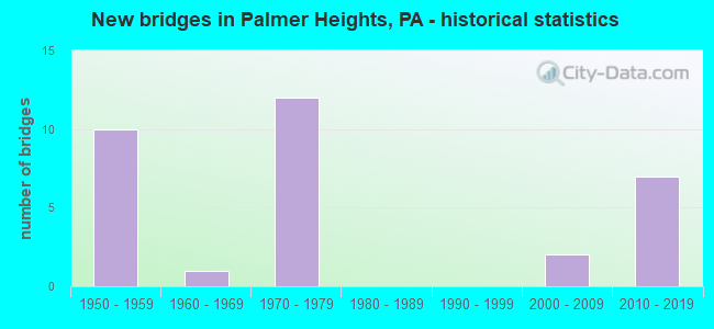
- New bridges - historical statistics
- 101950-1959
- 11960-1969
- 121970-1979
- 22000-2009
- 72010-2019

- Reconstructed bridges - Historical Statistics
- 11960-1969
- 01970-1979
- 01980-1989
- 31990-1999


- Bridge Condition - Deck
- 9.1%Excellent
- 9.1%Very good
- 36.4%Good
- 36.4%Satisfactory
- 9.1%Fair

- Bridge Condition - Superstructure
- 9.1%Excellent
- 9.1%Very good
- 18.2%Good
- 45.5%Satisfactory
- 18.2%Fair

- Bridge Condition - Substructure
- 9.1%Excellent
- 9.1%Very good
- 9.1%Good
- 36.4%Satisfactory
- 27.3%Fair
- 9.1%Poor

- Bridge Condition - Channel
- 25.0%Very good
- 25.0%Satisfactory
- 50.0%Fair

- Bridge Condition - Culverts
- 50.0%Good
- 50.0%Fair
Find on map >> Show street view
Structure Number: 2848, Location: T-454 OVER U.S. 22 (Lat: 40.683389, Lng: -75.292006), Route carried "on" structure: State highway , Year Built: 1954, Status: Open, Structure Length: 2.83m (9.28ft), Average Daily Traffic: 5,093 (year 2021), Truck Traffic: 4%, Average Future Daily Traffic: 4,808 (year 2032), Design Load: HS 20, Features Intersected: US 22 (LR 772), Facility Carried by Structure: SR2031COUNTRY CLUB
Minimum Vertical Clearance: 30+ m (98+ ft), Kilometerpoint: 0.000, Lanes on structure: 2, Lanes under structure: 8, Owner: State Highway Agency, Approaching Roadway Width: 7.3m (24.0ft), Material/Design: Steel, Design/Construction: Girder and Floorbeam System, Number Of Spans In Main Unit: 1, Length of Maximum Span: 25.9m (85.0ft), Curb or Sidewalk Widths: Left: 0.3m (1.0ft), Right: 0.3m (1.0ft), Curb-To-Curb Width: 9.8m (32.2ft), Out-to-Out Width: 10.4m (34.1ft)
Condition: Deck: Satisfactory, Superstructure: Fair, Substructure: Satisfactory, Operating Rating: 53.5 metric tons, Method Used To Determine Operating Rating: Load Factor (LF), Inventory Rating: 31.8 metric tons, Method Used To Determine Inventory Rating: Load Factor (LF), Structural Evaluation: Somewhat better than minimum adequacy, Deck Geometry: Meets minimum limits, Underclear: Meets minimum limits, Approach Roadway Alignment: Better than present minimum criteria, Length Of Structure Improvement: 3.60m (11.81ft), Designated Inspection Frequency: Every 24 months, Critical Feature Inspection Frequency: Every 12 months, Other Special Inspection Frequency: Every 12 months, Inspection Date: March 2021, Critical Feature Inspection Date: March 2021, Other Special Inspection Date: March 2021, Bridge Improvement Cost: $9,000, Roadway Improvement Cost: $26,000, Total Project Cost: $119,000, Deck Structure Type: Concrete Cast-file-Place, Wearing Surface/Protective System: Wearing Surface: Monolithic Concrete
Find on map >> Show street view
Structure Number: 28495, Location: HECKTOWN RD.OVER PA.33 (Lat: 40.697253, Lng: -75.289492), Route carried "on" structure: State highway , Year Built: 1972, Status: Open, Structure Length: 8.20m (26.90ft), Average Daily Traffic: 5,944 (year 2021), Truck Traffic: 6%, Average Future Daily Traffic: 11,512 (year 2032), Design Load: HS 20, Features Intersected: PA 33, Facility Carried by Structure: SR2042 HECKTOWN RD
Minimum Vertical Clearance: 30+ m (98+ ft), Kilometerpoint: 0.000, Lanes on structure: 2, Lanes under structure: 8, Owner: State Highway Agency, Approaching Roadway Width: 7.9m (25.9ft), Material/Design: Prestressed concrete, Design/Construction: Stringer/Multi-beam, Number Of Spans In Main Unit: 4, Length of Maximum Span: 29.6m (97.1ft), Curb or Sidewalk Widths: Left: 0.2m (0.7ft), Right: 0.2m (0.7ft), Curb-To-Curb Width: 13.4m (44.0ft), Out-to-Out Width: 14.6m (47.9ft)
Condition: Deck: Satisfactory, Superstructure: Satisfactory, Substructure: Satisfactory, Inventory Rating: 23.6 metric tons, Method Used To Determine Inventory Rating: Load Factor (LF), Structural Evaluation: Somewhat better than minimum adequacy, Deck Geometry: Equal to present minimum criteria, Underclear: Somewhat better than minimum adequacy, Approach Roadway Alignment: Equal to present desirable criteria, Length Of Structure Improvement: 9.20m (30.18ft), Designated Inspection Frequency: Every 24 months, Inspection Date: March 2021, Bridge Improvement Cost: $63,000, Roadway Improvement Cost: $187,000, Total Project Cost: $855,000, Deck Structure Type: Concrete Cast-file-Place, Wearing Surface/Protective System: Wearing Surface: Latex Concrete
Find on map >> Show street view
Structure Number: 28587, Location: 0.5 MI.E.OF PA33 (Lat: 40.712192, Lng: -75.282503), Route carried "on" structure: State highway 248, Year Built: 1960, Year Reconstructed: 1995, Status: Open, Structure Length: 0.85m (2.79ft), Average Daily Traffic: 15,460 (year 2021), Truck Traffic: 2%, Average Future Daily Traffic: 17,416 (year 2032), Design Load: HS 20, Features Intersected: TRIB.TO SHOENECK CREEK
Minimum Vertical Clearance: 30+ m (98+ ft), Kilometerpoint: 31.033, Lanes on structure: 4, Base Highway Network: Yes, Owner: State Highway Agency, Approaching Roadway Width: 24.4m (80.1ft), Skew: 3 degrees, Material/Design: Concrete, Design/Construction: Tee Beam, Number Of Spans In Main Unit: 1, Length of Maximum Span: 7.6m (24.9ft), Curb-To-Curb Width: 24.8m (81.4ft), Out-to-Out Width: 26.2m (86.0ft)
Condition: Deck: Good, Superstructure: Good, Substructure: Fair, Channel: Fair, Operating Rating: 74.4 metric tons, Method Used To Determine Operating Rating: Load Factor (LF), Inventory Rating: 44.5 metric tons, Method Used To Determine Inventory Rating: Load Factor (LF), Structural Evaluation: Somewhat better than minimum adequacy, Deck Geometry: Superior to present desirable criteria, Waterway Adequacy: Equal to present minimum criteria, Approach Roadway Alignment: Equal to present desirable criteria, Length Of Structure Improvement: 0.90m (2.95ft), Designated Inspection Frequency: Every 24 months, Inspection Date: October 2019, Bridge Improvement Cost: $6,000, Roadway Improvement Cost: $18,000, Total Project Cost: $81,000, Deck Structure Type: Concrete Cast-file-Place, Wearing Surface/Protective System: Wearing Surface: Integral Concrete, Deck Protection: Epoxy Coated Reinforcing
Find on map >> Show street view
Structure Number: 28589, Location: 25TH & NORTHAMPTON STS. (Lat: 40.687203, Lng: -75.252644), Route carried "on" structure: State highway 248, Year Built: 1954, Year Reconstructed: 1960, Status: Open, Structure Length: 0.70m (2.30ft), Average Daily Traffic: 23,500 (year 2020), Truck Traffic: 2%, Average Future Daily Traffic: 30,616 (year 2032), Design Load: HS 20, Features Intersected: TRIB.BUSHKILL CK.
Minimum Vertical Clearance: 30+ m (98+ ft), Kilometerpoint: 34.590, Lanes on structure: 6, Base Highway Network: Yes, Owner: State Highway Agency, Approaching Roadway Width: 15.8m (51.8ft), Skew: 20 degrees, Material/Design: Concrete, Design/Construction: Tee Beam, Number Of Spans In Main Unit: 1, Length of Maximum Span: 6.7m (22.0ft), Curb or Sidewalk Widths: Left: 1.5m (4.9ft), Right: 0.0m, Curb-To-Curb Width: 62.2m (204.1ft), Out-to-Out Width: 64.8m (212.6ft)
Condition: Deck: Satisfactory, Superstructure: Satisfactory, Substructure: Fair, Channel: Satisfactory, Operating Rating: 55.3 metric tons, Method Used To Determine Operating Rating: Load Factor (LF), Inventory Rating: 32.7 metric tons, Method Used To Determine Inventory Rating: Load Factor (LF), Structural Evaluation: Somewhat better than minimum adequacy, Deck Geometry: Superior to present desirable criteria, Waterway Adequacy: Equal to present minimum criteria, Approach Roadway Alignment: Equal to present desirable criteria, Length Of Structure Improvement: 1.30m (4.27ft), Designated Inspection Frequency: Every 24 months, Inspection Date: July 2021, Bridge Improvement Cost: $10,000, Roadway Improvement Cost: $28,000, Total Project Cost: $130,000, Deck Structure Type: Concrete Cast-file-Place, Wearing Surface/Protective System: Wearing Surface: Bituminous, Membrane: Other
Find on map >> Show street view
Structure Number: 28745, Location: GREENWOOD AVE.OVER U.S.22 (Lat: 40.683333, Lng: -75.261667), Route carried "on" structure: State highway , Year Built: 1954, Status: Open, Structure Length: 2.99m (9.81ft), Average Daily Traffic: 10,967 (year 2020), Truck Traffic: 2%, Average Future Daily Traffic: 17,007 (year 2032), Design Load: HS 20, Features Intersected: US 22 (LR 773), Facility Carried by Structure: SR 2028 (LR 48018)
Minimum Vertical Clearance: 30+ m (98+ ft), Kilometerpoint: 9.402, Lanes on structure: 2, Lanes under structure: 8, Owner: State Highway Agency, Approaching Roadway Width: 11.6m (38.1ft), Material/Design: Concrete, Design/Construction: Frame, Number Of Spans In Main Unit: 1, Length of Maximum Span: 25.9m (85.0ft), Curb or Sidewalk Widths: Left: 0.3m (1.0ft), Right: 0.3m (1.0ft), Curb-To-Curb Width: 12.2m (40.0ft), Out-to-Out Width: 13.4m (44.0ft)
Condition: Deck: Satisfactory, Superstructure: Satisfactory, Substructure: Fair, Operating Rating: 92.5 metric tons, Method Used To Determine Operating Rating: Load Factor (LF), Inventory Rating: 55.3 metric tons, Method Used To Determine Inventory Rating: Load Factor (LF), Structural Evaluation: Somewhat better than minimum adequacy, Deck Geometry: Somewhat better than minimum adequacy, Underclear: High priority of corrective action, Approach Roadway Alignment: Equal to present desirable criteria, Length Of Structure Improvement: 3.70m (12.14ft), Designated Inspection Frequency: Every 24 months, Inspection Date: December 2019, Bridge Improvement Cost: $26,000, Roadway Improvement Cost: $76,000, Total Project Cost: $348,000, Deck Structure Type: Concrete Cast-file-Place, Wearing Surface/Protective System: Wearing Surface: Bituminous
Find on map >> Show street view
Structure Number: 28749, Location: 25TH ST. INTERCHANGE (Lat: 40.688464, Lng: -75.252058), Route carried "on" structure: Spur State highway , Year Built: 1954, Status: Open, Structure Length: 0.70m (2.30ft), Average Daily Traffic: 7,140 (year 2020), Truck Traffic: 5%, Average Future Daily Traffic: 19,781 (year 2032), Design Load: HS 20, Features Intersected: SPRING BROOK, Facility Carried by Structure: SR 2040(LR 773SPE)
Minimum Vertical Clearance: 30+ m (98+ ft), Kilometerpoint: 0.000, Lanes on structure: 4, Owner: State Highway Agency, Approaching Roadway Width: 13.4m (44.0ft), Skew: 4 degrees, Material/Design: Concrete, Design/Construction: Culvert, Number Of Spans In Main Unit: 1, Length of Maximum Span: 7.0m (23.0ft)
Condition: Channel: Fair, Culverts: Fair, Operating Rating: 78.9 metric tons, Method Used To Determine Operating Rating: Load Factor (LF), Inventory Rating: 47.2 metric tons, Method Used To Determine Inventory Rating: Load Factor (LF), Structural Evaluation: Somewhat better than minimum adequacy, Waterway Adequacy: Better than present minimum criteria, Approach Roadway Alignment: Equal to present desirable criteria, Length Of Structure Improvement: 1.30m (4.27ft), Designated Inspection Frequency: Every 24 months, Inspection Date: October 2019
Find on map >> Show street view
Structure Number: 28771, Location: 2.2 MI.E.OF NEWBURG (Lat: 40.704083, Lng: -75.289792), Route carried "on" structure: State highway , Year Built: 1972, Status: Open, Structure Length: 8.44m (27.69ft), Average Daily Traffic: 8,760 (year 2021), Truck Traffic: 7%, Average Future Daily Traffic: 8,140 (year 2032), Design Load: HS 20, Features Intersected: PA 33 (LR 1098), Facility Carried by Structure: SR 3020 (LR 48063)
Minimum Vertical Clearance: 30+ m (98+ ft), Kilometerpoint: 9.093, Lanes on structure: 2, Lanes under structure: 8, Owner: State Highway Agency, Approaching Roadway Width: 13.4m (44.0ft), Skew: 1 degrees, Material/Design: Prestressed concrete, Design/Construction: Stringer/Multi-beam, Number Of Spans In Main Unit: 4, Length of Maximum Span: 29.9m (98.1ft), Curb-To-Curb Width: 13.4m (44.0ft), Out-to-Out Width: 14.6m (47.9ft)
Condition: Deck: Fair, Superstructure: Fair, Substructure: Poor, Operating Rating: 76.2 metric tons, Method Used To Determine Operating Rating: Load Factor (LF), Inventory Rating: 20.9 metric tons, Method Used To Determine Inventory Rating: Load Factor (LF), Structural Evaluation: Meets minimum limits, Deck Geometry: Equal to present minimum criteria, Underclear: Equal to present minimum criteria, Approach Roadway Alignment: Equal to present desirable criteria, Length Of Structure Improvement: 9.40m (30.84ft), Designated Inspection Frequency: Every 24 months, Inspection Date: October 2020, Bridge Improvement Cost: $58,000, Roadway Improvement Cost: $171,000, Total Project Cost: $784,000, Deck Structure Type: Concrete Cast-file-Place, Wearing Surface/Protective System: Wearing Surface: Monolithic Concrete
Find on map >> Show street view
Structure Number: 28951, Location: RAMP 22 EB TO PA 33 SB (Lat: 40.681550, Lng: -75.291558), Route carried "on" structure: Ramp State highway , Year Built: 1972, Year Reconstructed: 2001, Status: Open, Structure Length: 6.28m (20.60ft), Average Daily Traffic: 9,206 (year 2022), Truck Traffic: 7%, Average Future Daily Traffic: 9,386 (year 2032), Design Load: HS 20, Features Intersected: T-454(COUNTRY CLUB RD.), Facility Carried by Structure: LR1098 - RAMP B
Minimum Vertical Clearance: 30+ m (98+ ft), Kilometerpoint: 0.000, Lanes on structure: 1, Lanes under structure: 2, Owner: State Highway Agency, Approaching Roadway Width: 10.1m (33.1ft), Skew: 4 degrees, Material/Design: Steel, Design/Construction: Stringer/Multi-beam, Number Of Spans In Main Unit: 1, Number Of Approach Spans: 2, Length of Maximum Span: 38.1m (125.0ft), Curb-To-Curb Width: 9.2m (30.2ft), Out-to-Out Width: 10.5m (34.4ft)
Condition: Deck: Good, Superstructure: Satisfactory, Substructure: Satisfactory, Operating Rating: 65.3 metric tons, Method Used To Determine Operating Rating: Load Factor (LF), Inventory Rating: 39.0 metric tons, Method Used To Determine Inventory Rating: Load Factor (LF), Structural Evaluation: Equal to present minimum criteria, Deck Geometry: Superior to present desirable criteria, Underclear: Equal to present minimum criteria, Approach Roadway Alignment: Equal to present desirable criteria, Length Of Structure Improvement: 7.20m (23.62ft), Designated Inspection Frequency: Every 24 months, Inspection Date: March 2020, Deck Structure Type: Concrete Cast-file-Place, Wearing Surface/Protective System: Wearing Surface: Latex Concrete, Deck Protection: Epoxy Coated Reinforcing
Find on map >> Show street view
Structure Number: 28952, Location: RAMP 33 SB TO US 22 WEST. (Lat: 40.685256, Lng: -75.291989), Route carried "on" structure: Ramp State highway , Year Built: 1972, Year Reconstructed: 2001, Status: Open, Structure Length: 6.13m (20.11ft), Average Daily Traffic: 14,666 (year 2022), Truck Traffic: 7%, Average Future Daily Traffic: 17,193 (year 2032), Design Load: HS 20, Features Intersected: T-454(COUNTRY CLUB RD.), Facility Carried by Structure: LR 1098 RAMP C
Minimum Vertical Clearance: 30+ m (98+ ft), Kilometerpoint: 0.000, Lanes on structure: 1, Lanes under structure: 2, Owner: State Highway Agency, Approaching Roadway Width: 10.1m (33.1ft), Skew: 4 degrees, Material/Design: Steel, Design/Construction: Stringer/Multi-beam, Number Of Spans In Main Unit: 1, Number Of Approach Spans: 2, Length of Maximum Span: 37.8m (124.0ft), Curb-To-Curb Width: 9.2m (30.2ft), Out-to-Out Width: 10.5m (34.4ft)
Condition: Deck: Good, Superstructure: Satisfactory, Substructure: Satisfactory, Operating Rating: 48.1 metric tons, Method Used To Determine Operating Rating: Load Factor (LF), Inventory Rating: 28.1 metric tons, Method Used To Determine Inventory Rating: Load Factor (LF), Structural Evaluation: Equal to present minimum criteria, Deck Geometry: Superior to present desirable criteria, Underclear: Somewhat better than minimum adequacy, Approach Roadway Alignment: Equal to present desirable criteria, Length Of Structure Improvement: 7.00m (22.97ft), Designated Inspection Frequency: Every 24 months, Inspection Date: March 2020, Bridge Improvement Cost: $11,000, Roadway Improvement Cost: $31,000, Total Project Cost: $144,000, Deck Structure Type: Concrete Cast-file-Place, Wearing Surface/Protective System: Wearing Surface: Latex Concrete
Find on map >> Show street view
Structure Number: 41302, Location: OVER WM. PENN HWY. (Lat: 40.677833, Lng: -75.290647), Route carried "on" structure: State highway 33, Year Built: 2001, Status: Open, Structure Length: 3.38m (11.09ft), Average Daily Traffic: 35,392 (year 2021), Truck Traffic: 12%, Average Future Daily Traffic: 31,853 (year 2032), Design Load: HS 25 or greater, Features Intersected: SR 2020
Minimum Vertical Clearance: 30+ m (98+ ft), Kilometerpoint: 3.409, Lanes on structure: 2, Lanes under structure: 2, Base Highway Network: Yes, Owner: State Highway Agency, Approaching Roadway Width: 12.2m (40.0ft), Skew: 11 degrees, Material/Design: Prestressed concrete, Design/Construction: Stringer/Multi-beam, Number Of Spans In Main Unit: 1, Length of Maximum Span: 32.3m (106.0ft), Curb-To-Curb Width: 12.2m (40.0ft), Out-to-Out Width: 13.1m (43.0ft)
Condition: Deck: Good, Superstructure: Good, Substructure: Good, Inventory Rating: 45.4 metric tons, Method Used To Determine Inventory Rating: Load Factor (LF), Structural Evaluation: Better than present minimum criteria, Deck Geometry: Better than present minimum criteria, Underclear: Equal to present minimum criteria, Approach Roadway Alignment: Equal to present desirable criteria, Length Of Structure Improvement: 4.20m (13.78ft), Designated Inspection Frequency: Every 48 months, Inspection Date: October 2019, Deck Structure Type: Concrete Cast-file-Place, Wearing Surface/Protective System: Wearing Surface: Monolithic Concrete, Deck Protection: Epoxy Coated Reinforcing
Find on map >> Show street view
Structure Number: 53951, Location: US22/PA33 INTERCHANGE (Lat: 40.682833, Lng: -75.288964), Route carried "on" structure: State highway 33, Year Built: 2018, Status: Open, Structure Length: 6.71m (22.01ft), Average Daily Traffic: 35,042 (year 2022), Truck Traffic: 12%, Average Future Daily Traffic: 37,171 (year 2032), Design Load: HL 93, Features Intersected: SR 22 (LR 772)
Minimum Vertical Clearance: 30+ m (98+ ft), Kilometerpoint: 5.349, Lanes on structure: 3, Lanes under structure: 6, Base Highway Network: Yes, Owner: State Highway Agency, Maintenance Responsibility: Private, Approaching Roadway Width: 16.5m (54.1ft), Skew: 10 degrees, Material/Design: Prestressed concrete continuous, Design/Construction: Stringer/Multi-beam, Number Of Spans In Main Unit: 2, Length of Maximum Span: 33.5m (109.9ft), Curb-To-Curb Width: 19.4m (63.6ft), Out-to-Out Width: 20.0m (65.6ft)
Condition: Deck: Very good, Superstructure: Very good, Substructure: Very good, Operating Rating: 48.3 metric tons, Method Used To Determine Operating Rating: Assigned ratings based on Load and Resistance Factor Design (LRFD) reported by rating factor (RF) using HL93 loadings, Inventory Rating: 37.3 metric tons, Method Used To Determine Inventory Rating: Assigned ratings based on Load and Resistance Factor Design (LRFD) reported by rating factor (RF) using HL93 loadings, Structural Evaluation: Equal to present desirable criteria, Deck Geometry: Superior to present desirable criteria, Underclear: Equal to present minimum criteria, Approach Roadway Alignment: Equal to present desirable criteria, Designated Inspection Frequency: Every 24 months, Inspection Date: November 2020, Deck Structure Type: Concrete Cast-file-Place, Wearing Surface/Protective System: Wearing Surface: Integral Concrete, Deck Protection: Epoxy Coated Reinforcing
Find on map >> Show street view
Structure Number: 53952, Location: US22/PA33 INTERCHANGE (Lat: 40.682833, Lng: -75.288964), Route carried "on" structure: State highway 33, Year Built: 2017, Status: Open, Structure Length: 6.80m (22.31ft), Average Daily Traffic: 39,076 (year 2022), Truck Traffic: 10%, Average Future Daily Traffic: 36,210 (year 2032), Design Load: HL 93, Features Intersected: SR 22(LR 772)
Minimum Vertical Clearance: 30+ m (98+ ft), Kilometerpoint: 5.280, Lanes on structure: 3, Lanes under structure: 4, Base Highway Network: Yes, Owner: State Highway Agency, Maintenance Responsibility: Private, Approaching Roadway Width: 17.4m (57.1ft), Skew: 10 degrees, Material/Design: Prestressed concrete continuous, Design/Construction: Stringer/Multi-beam, Number Of Spans In Main Unit: 2, Length of Maximum Span: 33.5m (109.9ft), Curb-To-Curb Width: 19.8m (65.0ft), Out-to-Out Width: 20.4m (66.9ft)
Condition: Deck: Excellent, Superstructure: Excellent, Substructure: Excellent, Operating Rating: 44.4 metric tons, Method Used To Determine Operating Rating: Assigned ratings based on Load and Resistance Factor Design (LRFD) reported by rating factor (RF) using HL93 loadings, Inventory Rating: 34.0 metric tons, Method Used To Determine Inventory Rating: Assigned ratings based on Load and Resistance Factor Design (LRFD) reported by rating factor (RF) using HL93 loadings, Structural Evaluation: Superior to present desirable criteria, Deck Geometry: Superior to present desirable criteria, Underclear: High priority of corrective action, Approach Roadway Alignment: Equal to present desirable criteria, Designated Inspection Frequency: Every 24 months, Inspection Date: November 2021, Deck Structure Type: Concrete Cast-file-Place, Wearing Surface/Protective System: Wearing Surface: Integral Concrete, Deck Protection: Epoxy Coated Reinforcing
Find on map >> Show street view
Structure Number: 5734, Location: 0.3MI East of PA248 (Lat: 40.713639, Lng: -75.276556), Route carried "on" structure: City street , Year Built: 2014, Status: Open, Structure Length: 2.83m (9.28ft), Average Daily Traffic: 2,000 (year 2014), Average Future Daily Traffic: 2,200 (year 2034), Features Intersected: Shoeneck Creek, Facility Carried by Structure: Corriere Road
Minimum Vertical Clearance: 30+ m (98+ ft), Kilometerpoint: 0.000, Lanes on structure: 2, Owner: Town or Township Highway Agency, Approaching Roadway Width: 12.2m (40.0ft), Material/Design: Concrete, Design/Construction: Culvert, Number Of Spans In Main Unit: 2, Length of Maximum Span: 13.7m (44.9ft), Curb or Sidewalk Widths: Left: 2.4m (7.9ft), Right: 2.4m (7.9ft), Curb-To-Curb Width: 12.2m (40.0ft), Out-to-Out Width: 12.2m (40.0ft)
Condition: Channel: Very good, Culverts: Good, Operating Rating: 62.6 metric tons, Method Used To Determine Operating Rating: Load Factor (LF), Inventory Rating: 41.7 metric tons, Method Used To Determine Inventory Rating: Load Factor (LF), Structural Evaluation: Better than present minimum criteria, Deck Geometry: Better than present minimum criteria, Waterway Adequacy: Equal to present desirable criteria, Approach Roadway Alignment: Equal to present desirable criteria, Designated Inspection Frequency: Every 24 months, Inspection Date: December 2019
Find on map >> Show street view
Structure Number: 2848, Location: T-454 OVER U.S. 22 (Lat: 40.683389, Lng: -75.292006), Route carried "under" structure: US 22, Year Built: 1954, Structure Length: 0. m, Average Daily Traffic: 16,666 (year 2020), Truck Traffic: 5%, Features Intersected: US 22 (LR 772), Facility Carried by Structure: SR2031COUNTRY CLUB
Minimum Vertical Clearance: 4.33m (14.21ft), Kilometerpoint: 10.416, Lanes on structure: 2, Lanes under structure: 4, Material/Design: Steel, Design/Construction: Girder and Floorbeam System, Length of Maximum Span: 25.9m (85.0ft)
Find on map >> Show street view
Structure Number: 2848, Location: T-454 OVER U.S. 22 (Lat: 40.683389, Lng: -75.292006), Route carried "under" structure: US 22, Year Built: 1954, Structure Length: 0. m, Average Daily Traffic: 12,294 (year 2020), Truck Traffic: 6%, Features Intersected: US 22 (LR 772), Facility Carried by Structure: SR2031COUNTRY CLUB
Minimum Vertical Clearance: 4.33m (14.21ft), Kilometerpoint: 10.446, Lanes on structure: 2, Lanes under structure: 4, Material/Design: Steel, Design/Construction: Girder and Floorbeam System, Length of Maximum Span: 25.9m (85.0ft)
Find on map >> Show street view
Structure Number: 28495, Location: HECKTOWN RD.OVER PA.33 (Lat: 40.697253, Lng: -75.289492), Route carried "under" structure: State highway 33, Year Built: 1972, Structure Length: 0. m, Average Daily Traffic: 35,042 (year 2022), Truck Traffic: 12%, Features Intersected: PA 33, Facility Carried by Structure: SR2042 HECKTOWN RD
Minimum Vertical Clearance: 4.42m (14.50ft), Kilometerpoint: 6.944, Lanes on structure: 2, Lanes under structure: 4, Material/Design: Prestressed concrete, Design/Construction: Stringer/Multi-beam, Length of Maximum Span: 29.6m (97.1ft)
Find on map >> Show street view
Structure Number: 28495, Location: HECKTOWN RD.OVER PA.33 (Lat: 40.697253, Lng: -75.289492), Route carried "under" structure: State highway 33, Year Built: 1972, Structure Length: 0. m, Average Daily Traffic: 38,743 (year 2021), Truck Traffic: 11%, Features Intersected: PA 33, Facility Carried by Structure: SR2042 HECKTOWN RD
Minimum Vertical Clearance: 4.60m (15.09ft), Kilometerpoint: 6.875, Lanes on structure: 2, Lanes under structure: 4, Material/Design: Prestressed concrete, Design/Construction: Stringer/Multi-beam, Length of Maximum Span: 29.6m (97.1ft)
Find on map >> Show street view
Structure Number: 28743, Location: CHURCH RD. OVER PA.33 (Lat: 40.678733, Lng: -75.289553), Route carried "under" structure: State highway 33, Year Built: 1972, Structure Length: 0. m, Average Daily Traffic: 35,392 (year 2021), Truck Traffic: 12%, Features Intersected: PA 33 (LR 1098), Facility Carried by Structure: SR 2028 (LR 48017)
Minimum Vertical Clearance: 4.48m (14.70ft), Kilometerpoint: 4.514, Lanes on structure: 2, Lanes under structure: 4, Material/Design: Steel continuous, Design/Construction: Stringer/Multi-beam, Length of Maximum Span: 36.6m (120.1ft)
Find on map >> Show street view
Structure Number: 28743, Location: CHURCH RD. OVER PA.33 (Lat: 40.678733, Lng: -75.289553), Route carried "under" structure: State highway 33, Year Built: 1972, Structure Length: 0. m, Average Daily Traffic: 36,495 (year 2021), Truck Traffic: 15%, Features Intersected: PA 33 (LR 1098), Facility Carried by Structure: SR 2028 (LR 48017)
Minimum Vertical Clearance: 4.90m (16.08ft), Kilometerpoint: 4.567, Lanes on structure: 2, Lanes under structure: 4, Material/Design: Steel continuous, Design/Construction: Stringer/Multi-beam, Length of Maximum Span: 36.6m (120.1ft)
Find on map >> Show street view
Structure Number: 28744, Location: BETHMAN RD.OVER U.S.22 (Lat: 40.683014, Lng: -75.278542), Route carried "under" structure: US 22, Year Built: 1954, Structure Length: 0. m, Average Daily Traffic: 16,666 (year 2020), Truck Traffic: 5%, Features Intersected: US 22 (LR 772), Facility Carried by Structure: SR 2028 (LR 48017)
Minimum Vertical Clearance: 4.94m (16.21ft), Kilometerpoint: 12.081, Lanes on structure: 2, Lanes under structure: 4, Material/Design: Concrete, Design/Construction: Frame, Length of Maximum Span: 25.9m (85.0ft)
Find on map >> Show street view
Structure Number: 28744, Location: BETHMAN RD.OVER U.S.22 (Lat: 40.683014, Lng: -75.278542), Route carried "under" structure: US 22, Year Built: 1954, Structure Length: 0. m, Average Daily Traffic: 12,294 (year 2020), Truck Traffic: 6%, Features Intersected: US 22 (LR 772), Facility Carried by Structure: SR 2028 (LR 48017)
Minimum Vertical Clearance: 4.75m (15.58ft), Kilometerpoint: 12.097, Lanes on structure: 2, Lanes under structure: 4, Material/Design: Concrete, Design/Construction: Frame, Length of Maximum Span: 25.9m (85.0ft)
Find on map >> Show street view
Structure Number: 28745, Location: GREENWOOD AVE.OVER U.S.22 (Lat: 40.683333, Lng: -75.261667), Route carried "under" structure: US 22, Year Built: 1954, Structure Length: 0. m, Average Daily Traffic: 16,666 (year 2020), Truck Traffic: 5%, Features Intersected: US 22 (LR 773), Facility Carried by Structure: SR 2028 (LR 48018)
Minimum Vertical Clearance: 4.78m (15.68ft), Kilometerpoint: 13.501, Lanes on structure: 2, Lanes under structure: 4, Material/Design: Concrete, Design/Construction: Frame, Length of Maximum Span: 25.9m (85.0ft)
Find on map >> Show street view
Structure Number: 28745, Location: GREENWOOD AVE.OVER U.S.22 (Lat: 40.683333, Lng: -75.261667), Route carried "under" structure: US 22, Year Built: 1954, Structure Length: 0. m, Average Daily Traffic: 12,294 (year 2020), Truck Traffic: 6%, Features Intersected: US 22 (LR 773), Facility Carried by Structure: SR 2028 (LR 48018)
Minimum Vertical Clearance: 4.60m (15.09ft), Kilometerpoint: 13.515, Lanes on structure: 2, Lanes under structure: 4, Material/Design: Concrete, Design/Construction: Frame, Length of Maximum Span: 25.9m (85.0ft)
Find on map >> Show street view
Structure Number: 28771, Location: 2.2 MI.E.OF NEWBURG (Lat: 40.704083, Lng: -75.289792), Route carried "under" structure: State highway 33, Year Built: 1972, Structure Length: 0. m, Average Daily Traffic: 37,769 (year 2021), Truck Traffic: 12%, Features Intersected: PA 33 (LR 1098), Facility Carried by Structure: SR 3020 (LR 48063)
Minimum Vertical Clearance: 4.46m (14.63ft), Kilometerpoint: 7.701, Lanes on structure: 2, Lanes under structure: 4, Material/Design: Prestressed concrete, Design/Construction: Stringer/Multi-beam, Length of Maximum Span: 29.9m (98.1ft)
Find on map >> Show street view
Structure Number: 28771, Location: 2.2 MI.E.OF NEWBURG (Lat: 40.704083, Lng: -75.289792), Route carried "under" structure: State highway 33, Year Built: 1972, Structure Length: 0. m, Average Daily Traffic: 38,743 (year 2021), Truck Traffic: 11%, Features Intersected: PA 33 (LR 1098), Facility Carried by Structure: SR 3020 (LR 48063)
Minimum Vertical Clearance: 4.60m (15.09ft), Kilometerpoint: 7.641, Lanes on structure: 2, Lanes under structure: 4, Material/Design: Prestressed concrete, Design/Construction: Stringer/Multi-beam, Length of Maximum Span: 29.9m (98.1ft)
Find on map >> Show street view
Structure Number: 28951, Location: RAMP 22 EB TO PA 33 SB (Lat: 40.681550, Lng: -75.291558), Route carried "under" structure: City street T454, Year Built: 1972, Structure Length: 0. m, Average Daily Traffic: 330 (year 1990), Truck Traffic: 1%, Features Intersected: T-454(COUNTRY CLUB RD.), Facility Carried by Structure: LR1098 - RAMP B
Minimum Vertical Clearance: 4.48m (14.70ft), Kilometerpoint: 0.000, Lanes on structure: 1, Lanes under structure: 2, Material/Design: Steel, Design/Construction: Stringer/Multi-beam, Length of Maximum Span: 38.1m (125.0ft)
Find on map >> Show street view
Structure Number: 28952, Location: RAMP 33 SB TO US 22 WEST. (Lat: 40.685256, Lng: -75.291989), Route carried "under" structure: City street T454, Year Built: 1972, Structure Length: 0. m, Average Daily Traffic: 330 (year 1990), Truck Traffic: 5%, Features Intersected: T-454(COUNTRY CLUB RD.), Facility Carried by Structure: LR 1098 RAMP C
Minimum Vertical Clearance: 4.40m (14.44ft), Kilometerpoint: 0.000, Lanes on structure: 1, Lanes under structure: 2, Material/Design: Steel, Design/Construction: Stringer/Multi-beam, Length of Maximum Span: 37.8m (124.0ft)
Find on map >> Show street view
Structure Number: 41302, Location: OVER WM. PENN HWY. (Lat: 40.677833, Lng: -75.290647), Route carried "under" structure: State highway , Year Built: 2001, Structure Length: 0. m, Average Daily Traffic: 15,603 (year 2020), Truck Traffic: 3%, Features Intersected: SR 2020, Facility Carried by Structure: PA 33 SB
Minimum Vertical Clearance: 5.58m (18.31ft), Kilometerpoint: 7.783, Lanes on structure: 2, Lanes under structure: 2, Material/Design: Prestressed concrete, Design/Construction: Stringer/Multi-beam, Length of Maximum Span: 32.3m (106.0ft)
Find on map >> Show street view
Structure Number: 53951, Location: US22/PA33 INTERCHANGE (Lat: 40.682833, Lng: -75.288964), Route carried "under" structure: US 22, Year Built: 2018, Structure Length: 0. m, Average Daily Traffic: 16,666 (year 2020), Truck Traffic: 5%, Features Intersected: SR 22 (LR 772), Facility Carried by Structure: SR 33 (LR 1098NB)
Minimum Vertical Clearance: 5.15m (16.90ft), Kilometerpoint: 11.222, Lanes on structure: 3, Lanes under structure: 3, Material/Design: Prestressed concrete continuous, Design/Construction: Stringer/Multi-beam, Length of Maximum Span: 33.5m (109.9ft)
Find on map >> Show street view
Structure Number: 53951, Location: US22/PA33 INTERCHANGE (Lat: 40.682833, Lng: -75.288964), Route carried "under" structure: US 22, Year Built: 2018, Structure Length: 0. m, Average Daily Traffic: 12,294 (year 2020), Truck Traffic: 6%, Features Intersected: SR 22 (LR 772), Facility Carried by Structure: SR 33 (LR 1098NB)
Minimum Vertical Clearance: 5.24m (17.19ft), Kilometerpoint: 11.238, Lanes on structure: 3, Lanes under structure: 3, Material/Design: Prestressed concrete continuous, Design/Construction: Stringer/Multi-beam, Length of Maximum Span: 33.5m (109.9ft)
Find on map >> Show street view
Structure Number: 53952, Location: US22/PA33 INTERCHANGE (Lat: 40.682833, Lng: -75.288964), Route carried "under" structure: US 22, Year Built: 2017, Structure Length: 0. m, Average Daily Traffic: 16,666 (year 2020), Truck Traffic: 5%, Features Intersected: SR 22(LR 772), Facility Carried by Structure: SR 33 (LR 1098SB)
Minimum Vertical Clearance: 5.12m (16.80ft), Kilometerpoint: 10.416, Lanes on structure: 3, Lanes under structure: 2, Material/Design: Prestressed concrete continuous, Design/Construction: Stringer/Multi-beam, Length of Maximum Span: 33.5m (109.9ft)
Find on map >> Show street view
Structure Number: 53952, Location: US22/PA33 INTERCHANGE (Lat: 40.682833, Lng: -75.288964), Route carried "under" structure: US 22, Year Built: 2017, Structure Length: 0. m, Average Daily Traffic: 12,294 (year 2020), Truck Traffic: 6%, Features Intersected: SR 22(LR 772), Facility Carried by Structure: SR 33 (LR 1098SB)
Minimum Vertical Clearance: 5.21m (17.09ft), Kilometerpoint: 10.446, Lanes on structure: 3, Lanes under structure: 2, Material/Design: Prestressed concrete continuous, Design/Construction: Stringer/Multi-beam, Length of Maximum Span: 33.5m (109.9ft)