Bridge Statistics for Palm Springs North, Florida (FL)
Condition, Traffic, Stress, Structural Evaluation, Project Costs
- National Bridge Inventory (NBI) Statistics
- 10Number of bridges
- 98ft / 29.6mTotal length
- 486,200Total average daily traffic
- 34,804Total average daily truck traffic
- National Bridge Inventory (NBI) Registered Bridges for Palm Springs North
- No street view available for this location
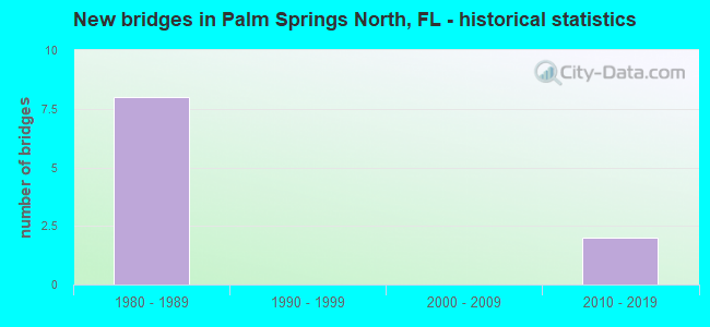
- New bridges - historical statistics
- 81980-1989
- 22010-2019


- Bridge Condition - Deck
- 33.3%Very good
- 66.7%Good

- Bridge Condition - Superstructure
- 66.7%Good
- 33.3%Satisfactory

- Bridge Condition - Substructure
- 33.3%Very good
- 66.7%Good
Find on map >> Show street view
Structure Number: 870594, Location: 1MI S OF BROWARD CO. LINE (Lat: 25.942417, Lng: -80.351056), Route carried "on" structure: Ramp State highway 860, Year Built: 1985, Status: Open, Structure Length: 11.97m (39.27ft), Average Daily Traffic: 21,250 (year 2020), Truck Traffic: 4%, Average Future Daily Traffic: 36,869 (year 2042), Design Load: HL 93, Features Intersected: I-75
Minimum Vertical Clearance: 30+ m (98+ ft), Kilometerpoint: 0.040, Lanes on structure: 2, Lanes under structure: 11, Owner: State Highway Agency, Approaching Roadway Width: 8.2m (26.9ft), Material/Design: Prestressed concrete, Design/Construction: Stringer/Multi-beam, Number Of Spans In Main Unit: 5, Length of Maximum Span: 34.7m (113.8ft), Curb-To-Curb Width: 8.2m (26.9ft), Out-to-Out Width: 9.1m (29.9ft)
Condition: Deck: Good, Superstructure: Good, Substructure: Good, Operating Rating: 40.8 metric tons, Method Used To Determine Operating Rating: Load and Resistance Factor (LRFR), Inventory Rating: 32.7 metric tons, Method Used To Determine Inventory Rating: Load and Resistance Factor (LRFR), Structural Evaluation: Better than present minimum criteria, Deck Geometry: High priority of corrective action, Underclear: Somewhat better than minimum adequacy, Approach Roadway Alignment: Equal to present minimum criteria, Designated Inspection Frequency: Every 24 months, Inspection Date: July 2020, Deck Structure Type: Concrete Cast-file-Place
Find on map >> Show street view
Structure Number: 870595, Location: 1MI S OF BROWARD CO. LINE (Lat: 25.942222, Lng: -80.351083), Route carried "on" structure: Ramp State highway 860, Year Built: 1985, Status: Open, Structure Length: 11.97m (39.27ft), Average Daily Traffic: 21,250 (year 2020), Truck Traffic: 4%, Average Future Daily Traffic: 36,869 (year 2042), Design Load: HL 93, Features Intersected: I-75
Minimum Vertical Clearance: 30+ m (98+ ft), Kilometerpoint: 0.040, Lanes on structure: 2, Lanes under structure: 11, Owner: State Highway Agency, Approaching Roadway Width: 8.8m (28.9ft), Material/Design: Prestressed concrete, Design/Construction: Stringer/Multi-beam, Number Of Spans In Main Unit: 5, Length of Maximum Span: 34.7m (113.8ft), Curb-To-Curb Width: 8.2m (26.9ft), Out-to-Out Width: 9.1m (29.9ft)
Condition: Deck: Good, Superstructure: Good, Substructure: Good, Operating Rating: 40.8 metric tons, Method Used To Determine Operating Rating: Load and Resistance Factor (LRFR), Inventory Rating: 32.7 metric tons, Method Used To Determine Inventory Rating: Load and Resistance Factor (LRFR), Structural Evaluation: Better than present minimum criteria, Deck Geometry: High priority of corrective action, Underclear: Somewhat better than minimum adequacy, Approach Roadway Alignment: Equal to present minimum criteria, Designated Inspection Frequency: Every 24 months, Inspection Date: July 2020, Deck Structure Type: Concrete Cast-file-Place
Find on map >> Show street view
Structure Number: 871176, Location: 0.14 Mi N of NW 186th St. (Lat: 25.944406, Lng: -80.350578), Route carried "on" structure: Interstate 75, Year Built: 2017, Status: Open, Structure Length: 5.61m (18.41ft), Average Daily Traffic: 129,500 (year 2019), Truck Traffic: 6%, Average Future Daily Traffic: 224,683 (year 2041), Design Load: HL 93, Features Intersected: Ramp
Minimum Vertical Clearance: 30+ m (98+ ft), Kilometerpoint: 0.266, Lanes on structure: 1, Lanes under structure: 1, Base Highway Network: Yes, Owner: State Highway Agency, Approaching Roadway Width: 12.2m (40.0ft), Skew: 4 degrees, Material/Design: Prestressed concrete, Design/Construction: Stringer/Multi-beam, Number Of Spans In Main Unit: 1, Length of Maximum Span: 56.1m (184.1ft), Curb-To-Curb Width: 12.4m (40.7ft), Out-to-Out Width: 13.1m (43.0ft)
Condition: Deck: Very good, Superstructure: Satisfactory, Substructure: Very good, Operating Rating: 85.9 metric tons, Method Used To Determine Operating Rating: Load and Resistance Factor (LRFR), Inventory Rating: 56.2 metric tons, Method Used To Determine Inventory Rating: Load and Resistance Factor (LRFR), Structural Evaluation: Equal to present minimum criteria, Deck Geometry: Somewhat better than minimum adequacy, Underclear: Somewhat better than minimum adequacy, Approach Roadway Alignment: Equal to present desirable criteria, Designated Inspection Frequency: Every 24 months, Inspection Date: December 2020, Deck Structure Type: Concrete Cast-file-Place
Find on map >> Show street view
Structure Number: 870594, Location: 1MI S OF BROWARD CO. LINE (Lat: 25.942417, Lng: -80.351056), Route carried "under" structure: Interstate 75, Year Built: 1985, Structure Length: 0. m, Average Daily Traffic: 5,300 (year 2020), Truck Traffic: 12%, Features Intersected: I-75, Facility Carried by Structure: NW186 ST(SR860) WB
Minimum Vertical Clearance: 5.18m (16.99ft), Kilometerpoint: 7.680, Lanes on structure: 2, Lanes under structure: 1, Toll: On toll road, Material/Design: Prestressed concrete, Design/Construction: Stringer/Multi-beam, Length of Maximum Span: 34.7m (113.8ft)
Find on map >> Show street view
Structure Number: 870594, Location: 1MI S OF BROWARD CO. LINE (Lat: 25.942417, Lng: -80.351056), Route carried "under" structure: Interstate 75, Year Built: 1985, Structure Length: 0. m, Average Daily Traffic: 140,000 (year 2020), Truck Traffic: 8%, Features Intersected: I-75, Facility Carried by Structure: NW186 ST(SR860) WB
Minimum Vertical Clearance: 5.00m (16.40ft), Kilometerpoint: 7.187, Lanes on structure: 2, Lanes under structure: 9, Material/Design: Prestressed concrete, Design/Construction: Stringer/Multi-beam, Length of Maximum Span: 34.7m (113.8ft)
Find on map >> Show street view
Structure Number: 870594, Location: 1MI S OF BROWARD CO. LINE (Lat: 25.942417, Lng: -80.351056), Route carried "under" structure: Interstate 75, Year Built: 1985, Structure Length: 0. m, Average Daily Traffic: 5,300 (year 2020), Truck Traffic: 12%, Features Intersected: I-75, Facility Carried by Structure: NW186 ST(SR860) WB
Minimum Vertical Clearance: 5.18m (16.99ft), Kilometerpoint: 1.558, Lanes on structure: 2, Lanes under structure: 1, Material/Design: Prestressed concrete, Design/Construction: Stringer/Multi-beam, Length of Maximum Span: 34.7m (113.8ft)
Find on map >> Show street view
Structure Number: 870595, Location: 1MI S OF BROWARD CO. LINE (Lat: 25.942222, Lng: -80.351083), Route carried "under" structure: Interstate 75, Year Built: 1985, Structure Length: 0. m, Average Daily Traffic: 5,300 (year 2020), Truck Traffic: 12%, Features Intersected: I-75, Facility Carried by Structure: NW186 ST(SR860) EB
Minimum Vertical Clearance: 5.18m (16.99ft), Kilometerpoint: 1.558, Lanes on structure: 2, Lanes under structure: 1, Toll: On toll road, Material/Design: Prestressed concrete, Design/Construction: Stringer/Multi-beam, Length of Maximum Span: 34.7m (113.8ft)
Find on map >> Show street view
Structure Number: 870595, Location: 1MI S OF BROWARD CO. LINE (Lat: 25.942222, Lng: -80.351083), Route carried "under" structure: Interstate 75, Year Built: 1985, Structure Length: 0. m, Average Daily Traffic: 140,000 (year 2020), Truck Traffic: 8%, Features Intersected: I-75, Facility Carried by Structure: NW186 ST(SR860) EB
Minimum Vertical Clearance: 5.00m (16.40ft), Kilometerpoint: 7.163, Lanes on structure: 2, Lanes under structure: 9, Material/Design: Prestressed concrete, Design/Construction: Stringer/Multi-beam, Length of Maximum Span: 34.7m (113.8ft)
Find on map >> Show street view
Structure Number: 870595, Location: 1MI S OF BROWARD CO. LINE (Lat: 25.942222, Lng: -80.351083), Route carried "under" structure: Interstate 75, Year Built: 1985, Structure Length: 0. m, Average Daily Traffic: 5,300 (year 2020), Truck Traffic: 12%, Features Intersected: I-75, Facility Carried by Structure: NW186 ST(SR860) EB
Minimum Vertical Clearance: 5.18m (16.99ft), Kilometerpoint: 7.680, Lanes on structure: 2, Lanes under structure: 1, Toll: On toll road, Material/Design: Prestressed concrete, Design/Construction: Stringer/Multi-beam, Length of Maximum Span: 34.7m (113.8ft)
Find on map >> Show street view
Structure Number: 871176, Location: 0.14 Mi N of NW 186th St. (Lat: 25.944406, Lng: -80.350578), Route carried "under" structure: State highway 186, Year Built: 2017, Structure Length: 0. m, Average Daily Traffic: 13,000 (year 2020), Truck Traffic: 3%, Features Intersected: Ramp, Facility Carried by Structure: I-75 NB
Minimum Vertical Clearance: 5.14m (16.86ft), Kilometerpoint: 0.629, Lanes on structure: 1, Lanes under structure: 1, Material/Design: Prestressed concrete, Design/Construction: Stringer/Multi-beam, Length of Maximum Span: 56.1m (184.1ft)