Bridge Statistics for Palisade, Nebraska (NE)
Condition, Traffic, Stress, Structural Evaluation, Project Costs
- National Bridge Inventory (NBI) Statistics
- 12Number of bridges
- 105ft / 32.4mTotal length
- $1,000Total costs
- 5,205Total average daily traffic
- 1,060Total average daily truck traffic
- 7,230Total future (year 2033) average daily traffic
- National Bridge Inventory (NBI) Registered Bridges for Palisade
- No street view available for this location
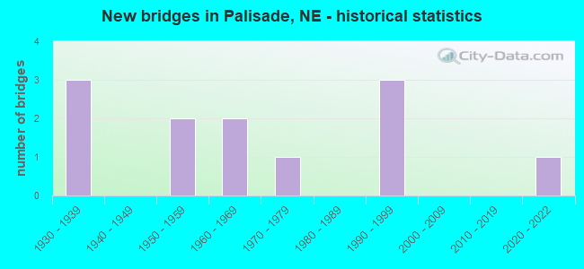
- New bridges - historical statistics
- 31930-1939
- 21950-1959
- 21960-1969
- 11970-1979
- 31990-1999
- 12020-2022

- Reconstructed bridges - Historical Statistics
- 31980-1989
- 01990-1999
- 12000-2009

- Bridge Condition - Deck
- 22.2%Excellent
- 22.2%Very good
- 11.1%Good
- 44.4%Fair

- Bridge Condition - Superstructure
- 22.2%Excellent
- 33.3%Very good
- 33.3%Good
- 11.1%Fair

- Bridge Condition - Substructure
- 33.3%Excellent
- 11.1%Very good
- 33.3%Good
- 22.2%Poor

- Bridge Condition - Channel
- 16.7%Excellent
- 41.7%Very good
- 16.7%Good
- 8.3%Satisfactory
- 16.7%Fair

- Bridge Condition - Culverts
- 33.3%Very good
- 33.3%Good
- 33.3%Satisfactory
Find on map >> Show street view
Structure Number: NKA-CULB-006, Location: 1.8 mi E of Palisade (Lat: 40.350714, Lng: -101.073903), Route carried "on" structure: County highway , Year Built: 1957, Year Reconstructed: 1980, Status: Open, Structure Length: 0.87m (2.85ft), Average Daily Traffic: 25 (year 2014), Average Future Daily Traffic: 30 (year 2040), Features Intersected: Culbertson Canal, Facility Carried by Structure: E. County Road Ave
Minimum Vertical Clearance: 30+ m (98+ ft), Kilometerpoint: 0.000, Lanes on structure: 2, Owner: Bureau of Reclamation, Maintenance Responsibility: Local Agency, Approaching Roadway Width: 7.6m (24.9ft), Skew: 4 degrees, Material/Design: Concrete continuous, Design/Construction: Culvert, Number Of Spans In Main Unit: 2, Length of Maximum Span: 4.3m (14.1ft)
Condition: Channel: Satisfactory, Culverts: Satisfactory, Operating Rating: 32.4 metric tons, Method Used To Determine Operating Rating: Load Factor (LF), Inventory Rating: 21.6 metric tons, Method Used To Determine Inventory Rating: Load Factor (LF), Structural Evaluation: Equal to present minimum criteria, Waterway Adequacy: Superior to present desirable criteria, Approach Roadway Alignment: Equal to present desirable criteria, Designated Inspection Frequency: Every 24 months, Inspection Date: June 2020, Bridge Improvement Cost: $1,000, Total Project Cost: $1,000 ( Estimate for 2020)
Find on map >> Show street view
Structure Number: NKA-CULB-007, Location: 2.6 mi E of Palisade (Lat: 40.340747, Lng: -101.059950), Route carried "on" structure: County highway 725, Year Built: 1957, Year Reconstructed: 1980, Status: Open, Structure Length: 0.67m (2.20ft), Average Daily Traffic: 20 (year 2014), Average Future Daily Traffic: 25 (year 2040), Features Intersected: Culbertson Canal
Minimum Vertical Clearance: 30+ m (98+ ft), Kilometerpoint: 0.000, Lanes on structure: 2, Owner: Bureau of Reclamation, Maintenance Responsibility: Local Agency, Approaching Roadway Width: 7.6m (24.9ft), Skew: 2 degrees, Material/Design: Concrete continuous, Design/Construction: Culvert, Number Of Spans In Main Unit: 2, Length of Maximum Span: 3.4m (11.2ft)
Condition: Channel: Good, Culverts: Good, Operating Rating: 32.4 metric tons, Method Used To Determine Operating Rating: Load Factor (LF), Inventory Rating: 21.6 metric tons, Method Used To Determine Inventory Rating: Load Factor (LF), Structural Evaluation: Equal to present minimum criteria, Waterway Adequacy: Superior to present desirable criteria, Approach Roadway Alignment: Equal to present desirable criteria, Designated Inspection Frequency: Every 24 months, Inspection Date: June 2020
Find on map >> Show street view
Structure Number: C004302510P, Location: 1N OF PALISADE (Lat: 40.365300, Lng: -101.106100), Route carried "on" structure: County highway 7268, Year Built: 1932, Status: Open, Structure Length: 2.50m (8.20ft), Average Daily Traffic: 60 (year 1998), Average Future Daily Traffic: 60 (year 2033), Features Intersected: FRENCHMAN CREEK, Facility Carried by Structure: AVE 359A
Minimum Vertical Clearance: 30+ m (98+ ft), Kilometerpoint: 0.137, Lanes on structure: 2, Owner: County Highway Agency, Approaching Roadway Width: 6.7m (22.0ft), Skew: 3 degrees, Material/Design: Steel, Design/Construction: Stringer/Multi-beam, Number Of Spans In Main Unit: 3, Length of Maximum Span: 8.2m (26.9ft), Curb-To-Curb Width: 7.3m (24.0ft), Out-to-Out Width: 7.7m (25.3ft)
Condition: Deck: Fair, Superstructure: Fair, Substructure: Poor, Channel: Fair, Operating Rating: 55.0 metric tons, Method Used To Determine Operating Rating: Load Factor (LF), Inventory Rating: 33.0 metric tons, Method Used To Determine Inventory Rating: Load Factor (LF), Structural Evaluation: Meets minimum limits, Deck Geometry: Equal to present minimum criteria, Waterway Adequacy: Meets minimum limits, Approach Roadway Alignment: Equal to present minimum criteria, Length Of Structure Improvement: 2.50m (8.20ft), Designated Inspection Frequency: Every 24 months, Inspection Date: September 2020, Deck Structure Type: Concrete Cast-file-Place, Wearing Surface/Protective System: Wearing Surface: Monolithic Concrete
Find on map >> Show street view
Structure Number: C004302515P, Location: 2N OF PALISADE (Lat: 40.376700, Lng: -101.103300), Route carried "on" structure: County highway P25, Year Built: 1932, Status: Open, Structure Length: 1.68m (5.51ft), Average Daily Traffic: 20 (year 2003), Average Future Daily Traffic: 25 (year 2033), Design Load: H 15, Features Intersected: STREAM, Facility Carried by Structure: COUNTY HIGHWAY
Minimum Vertical Clearance: 30+ m (98+ ft), Kilometerpoint: 0.000, Lanes on structure: 2, Owner: County Highway Agency, Approaching Roadway Width: 7.9m (25.9ft), Skew: 4 degrees, Material/Design: Steel, Design/Construction: Stringer/Multi-beam, Number Of Spans In Main Unit: 2, Length of Maximum Span: 8.2m (26.9ft), Curb-To-Curb Width: 7.3m (24.0ft), Out-to-Out Width: 7.7m (25.3ft)
Condition: Deck: Fair, Superstructure: Good, Substructure: Poor, Channel: Fair, Operating Rating: 67.0 metric tons, Method Used To Determine Operating Rating: Load Factor (LF), Inventory Rating: 40.0 metric tons, Method Used To Determine Inventory Rating: Load Factor (LF), Structural Evaluation: Meets minimum limits, Deck Geometry: Equal to present minimum criteria, Waterway Adequacy: Somewhat better than minimum adequacy, Approach Roadway Alignment: Meets minimum limits, Designated Inspection Frequency: Every 24 months, Inspection Date: September 2020, Deck Structure Type: Concrete Cast-file-Place, Wearing Surface/Protective System: Wearing Surface: Monolithic Concrete
Find on map >> Show street view
Structure Number: C004402305P, Location: JCT US6/N25A 2.3S (Lat: 40.315000, Lng: -101.111500), Route carried "on" structure: County highway 1370, Year Built: 2020, Status: Open, Structure Length: 3.57m (11.71ft), Average Daily Traffic: 120 (year 2011), Average Future Daily Traffic: 120 (year 2033), Design Load: HL 93, Features Intersected: BOBTAIL CREEK, Facility Carried by Structure: ROAD 359
Minimum Vertical Clearance: 30+ m (98+ ft), Kilometerpoint: 0.356, Lanes on structure: 2, Owner: County Highway Agency, Approaching Roadway Width: 7.3m (24.0ft), Material/Design: Steel, Design/Construction: Stringer/Multi-beam, Number Of Spans In Main Unit: 3, Length of Maximum Span: 11.9m (39.0ft), Curb or Sidewalk Widths: Left: 0.5m (1.6ft), Right: 0.5m (1.6ft), Curb-To-Curb Width: 8.5m (27.9ft), Out-to-Out Width: 9.4m (30.8ft)
Condition: Deck: Excellent, Superstructure: Excellent, Substructure: Excellent, Channel: Excellent, Operating Rating: 52.0 metric tons, Method Used To Determine Operating Rating: Load and Resistance Factor (LRFR), Inventory Rating: 40.0 metric tons, Method Used To Determine Inventory Rating: Load and Resistance Factor (LRFR), Structural Evaluation: Superior to present desirable criteria, Deck Geometry: Equal to present minimum criteria, Waterway Adequacy: Superior to present desirable criteria, Approach Roadway Alignment: Equal to present desirable criteria, Length Of Structure Improvement: 3.57m (11.71ft), Designated Inspection Frequency: Every 24 months, Inspection Date: August 2021, Deck Structure Type: Concrete Precast Panels, Wearing Surface/Protective System: Wearing Surface: Monolithic Concrete
Find on map >> Show street view
Structure Number: C00442021, Location: 1E US6 HAYES CL (Lat: 40.350900, Lng: -101.100500), Route carried "on" structure: County highway 7264, Year Built: 1999, Status: Open, Structure Length: 2.50m (8.20ft), Average Daily Traffic: 100 (year 1998), Average Future Daily Traffic: 170 (year 2033), Design Load: HS 20, Features Intersected: BOBTAIL CREEK
Minimum Vertical Clearance: 30+ m (98+ ft), Kilometerpoint: 0.063, Lanes on structure: 2, Owner: County Highway Agency, Approaching Roadway Width: 7.6m (24.9ft), Material/Design: Prestressed concrete, Design/Construction: Tee Beam, Number Of Spans In Main Unit: 3, Length of Maximum Span: 9.8m (32.2ft), Curb-To-Curb Width: 8.5m (27.9ft), Out-to-Out Width: 9.2m (30.2ft)
Condition: Deck: Very good, Superstructure: Excellent, Substructure: Excellent, Channel: Excellent, Operating Rating: 64.0 metric tons, Method Used To Determine Operating Rating: Load Factor (LF), Inventory Rating: 39.0 metric tons, Method Used To Determine Inventory Rating: Load Factor (LF), Structural Evaluation: Superior to present desirable criteria, Deck Geometry: Better than present minimum criteria, Waterway Adequacy: Superior to present desirable criteria, Approach Roadway Alignment: Equal to present desirable criteria, Designated Inspection Frequency: Every 24 months, Inspection Date: August 2021, Deck Structure Type: Concrete Cast-file-Place, Wearing Surface/Protective System: Wearing Surface: Monolithic Concrete
Find on map >> Show street view
Structure Number: C004420215, Location: 2E US6 HAYES CL (Lat: 40.350700, Lng: -101.078000), Route carried "on" structure: County highway 7264, Year Built: 1998, Status: Open, Structure Length: 3.26m (10.70ft), Average Daily Traffic: 100 (year 1998), Average Future Daily Traffic: 170 (year 2033), Features Intersected: FRENCHMAN CREEK
Minimum Vertical Clearance: 30+ m (98+ ft), Kilometerpoint: 0.251, Lanes on structure: 2, Owner: County Highway Agency, Approaching Roadway Width: 7.9m (25.9ft), Skew: 2 degrees, Material/Design: Prestressed concrete, Design/Construction: Tee Beam, Number Of Spans In Main Unit: 3, Length of Maximum Span: 11.6m (38.1ft), Curb-To-Curb Width: 8.5m (27.9ft), Out-to-Out Width: 9.2m (30.2ft)
Condition: Deck: Excellent, Superstructure: Very good, Substructure: Excellent, Channel: Very good, Operating Rating: 68.0 metric tons, Method Used To Determine Operating Rating: Load Factor (LF), Inventory Rating: 41.0 metric tons, Method Used To Determine Inventory Rating: Load Factor (LF), Structural Evaluation: Equal to present desirable criteria, Deck Geometry: Better than present minimum criteria, Waterway Adequacy: Superior to present desirable criteria, Approach Roadway Alignment: Equal to present desirable criteria, Length Of Structure Improvement: 3.38m (11.09ft), Designated Inspection Frequency: Every 24 months, Inspection Date: August 2021, Deck Structure Type: Concrete Cast-file-Place, Wearing Surface/Protective System: Wearing Surface: Monolithic Concrete
Find on map >> Show street view
Structure Number: S006 05643, Location: 1W PALISADE (Lat: 40.351800, Lng: -101.123600), Route carried "on" structure: US 6, Year Built: 1974, Year Reconstructed: 2014, Status: Open, Structure Length: 3.72m (12.20ft), Average Daily Traffic: 1,600 (year 2018), Truck Traffic: 17%, Average Future Daily Traffic: 2,240 (year 2038), Features Intersected: FRENCHMAN CREEK
Minimum Vertical Clearance: 30+ m (98+ ft), Kilometerpoint: 9.082, Lanes on structure: 2, Base Highway Network: Yes, Owner: State Highway Agency, Approaching Roadway Width: 7.3m (24.0ft), Material/Design: Concrete continuous, Design/Construction: Slab, Number Of Spans In Main Unit: 3, Length of Maximum Span: 14.9m (48.9ft), Curb or Sidewalk Widths: Left: 0.2m (0.7ft), Right: 0.2m (0.7ft), Curb-To-Curb Width: 12.2m (40.0ft), Out-to-Out Width: 13.1m (43.0ft)
Condition: Deck: Very good, Superstructure: Very good, Substructure: Good, Channel: Good, Operating Rating: 55.0 metric tons, Method Used To Determine Operating Rating: Load Factor (LF), Inventory Rating: 33.0 metric tons, Method Used To Determine Inventory Rating: Load Factor (LF), Structural Evaluation: Better than present minimum criteria, Deck Geometry: Better than present minimum criteria, Waterway Adequacy: Equal to present minimum criteria, Approach Roadway Alignment: Equal to present desirable criteria, Designated Inspection Frequency: Every 24 months, Inspection Date: May 2020, Deck Structure Type: Concrete Cast-file-Place, Wearing Surface/Protective System: Wearing Surface: Bituminous, Membrane: Preformed Fabric
Find on map >> Show street view
Structure Number: S006 05795, Location: 1E PALISADE (Lat: 40.344500, Lng: -101.104000), Route carried "on" structure: US 6, Year Built: 1990, Status: Open, Structure Length: 4.97m (16.31ft), Average Daily Traffic: 1,405 (year 2018), Truck Traffic: 26%, Average Future Daily Traffic: 1,967 (year 2038), Features Intersected: BOBTAIL CREEK
Minimum Vertical Clearance: 30+ m (98+ ft), Kilometerpoint: 9.326, Lanes on structure: 2, Base Highway Network: Yes, Owner: State Highway Agency, Approaching Roadway Width: 7.3m (24.0ft), Material/Design: Prestressed concrete, Design/Construction: Tee Beam, Number Of Spans In Main Unit: 3, Length of Maximum Span: 16.5m (54.1ft), Curb-To-Curb Width: 11.0m (36.1ft), Out-to-Out Width: 11.7m (38.4ft)
Condition: Deck: Good, Superstructure: Good, Substructure: Good, Channel: Very good, Operating Rating: 64.0 metric tons, Method Used To Determine Operating Rating: Load Factor (LF), Inventory Rating: 35.0 metric tons, Method Used To Determine Inventory Rating: Load Factor (LF), Structural Evaluation: Better than present minimum criteria, Deck Geometry: Equal to present minimum criteria, Waterway Adequacy: Equal to present desirable criteria, Approach Roadway Alignment: Equal to present desirable criteria, Designated Inspection Frequency: Every 24 months, Inspection Date: May 2020, Deck Structure Type: Concrete Cast-file-Place, Wearing Surface/Protective System: Wearing Surface: Monolithic Concrete, Deck Protection: Epoxy Coated Reinforcing
Find on map >> Show street view
Structure Number: S006 05941, Location: 2E PALISADE (Lat: 40.334900, Lng: -101.079300), Route carried "on" structure: US 6, Year Built: 1937, Year Reconstructed: 1989, Status: Open, Structure Length: 0.82m (2.69ft), Average Daily Traffic: 1,405 (year 2018), Truck Traffic: 26%, Average Future Daily Traffic: 1,967 (year 2038), Features Intersected: STREAM
Minimum Vertical Clearance: 30+ m (98+ ft), Kilometerpoint: 9.561, Lanes on structure: 2, Base Highway Network: Yes, Owner: State Highway Agency, Approaching Roadway Width: 7.3m (24.0ft), Skew: 1 degrees, Material/Design: Concrete, Design/Construction: Culvert, Number Of Spans In Main Unit: 4, Length of Maximum Span: 1.8m (5.9ft)
Condition: Channel: Very good, Culverts: Very good, Operating Rating: 33.0 metric tons, Method Used To Determine Operating Rating: Field evaluation and documented engineering judgment, Inventory Rating: 22.0 metric tons, Method Used To Determine Inventory Rating: Field evaluation and documented engineering judgment, Structural Evaluation: Somewhat better than minimum adequacy, Waterway Adequacy: Equal to present desirable criteria, Approach Roadway Alignment: Equal to present desirable criteria, Designated Inspection Frequency: Every 24 months, Inspection Date: May 2020
Find on map >> Show street view
Structure Number: S025A00095, Location: IN PALISADE (Lat: 40.358900, Lng: -101.103400), Route carried "on" structure: State highway 25A, Year Built: 1964, Status: Open, Structure Length: 5.91m (19.39ft), Average Daily Traffic: 175 (year 2018), Truck Traffic: 17%, Average Future Daily Traffic: 228 (year 2038), Features Intersected: FRENCHMAN CREEK
Minimum Vertical Clearance: 30+ m (98+ ft), Kilometerpoint: 0.153, Lanes on structure: 2, Owner: State Highway Agency, Approaching Roadway Width: 7.6m (24.9ft), Skew: 2 degrees, Material/Design: Steel continuous, Design/Construction: Stringer/Multi-beam, Number Of Spans In Main Unit: 3, Length of Maximum Span: 21.9m (71.9ft), Curb-To-Curb Width: 8.5m (27.9ft), Out-to-Out Width: 10.1m (33.1ft)
Condition: Deck: Fair, Superstructure: Good, Substructure: Good, Channel: Very good, Operating Rating: 37.0 metric tons, Method Used To Determine Operating Rating: Load Factor (LF), Inventory Rating: 22.0 metric tons, Method Used To Determine Inventory Rating: Load Factor (LF), Structural Evaluation: Equal to present minimum criteria, Deck Geometry: Equal to present minimum criteria, Waterway Adequacy: Equal to present minimum criteria, Approach Roadway Alignment: Equal to present desirable criteria, Designated Inspection Frequency: Every 24 months, Inspection Date: May 2020, Deck Structure Type: Concrete Cast-file-Place, Wearing Surface/Protective System: Wearing Surface: Monolithic Concrete
Find on map >> Show street view
Structure Number: S025A00116, Location: IN PALISADE (Lat: 40.361600, Lng: -101.101500), Route carried "on" structure: State highway 25A, Year Built: 1964, Status: Open, Structure Length: 1.89m (6.20ft), Average Daily Traffic: 175 (year 2018), Truck Traffic: 17%, Average Future Daily Traffic: 228 (year 2038), Features Intersected: CULBERTSON CANAL
Minimum Vertical Clearance: 30+ m (98+ ft), Kilometerpoint: 0.187, Lanes on structure: 2, Owner: State Highway Agency, Approaching Roadway Width: 7.6m (24.9ft), Skew: 1 degrees, Material/Design: Steel, Design/Construction: Stringer/Multi-beam, Number Of Spans In Main Unit: 1, Length of Maximum Span: 18.3m (60.0ft), Curb-To-Curb Width: 10.4m (34.1ft), Out-to-Out Width: 11.0m (36.1ft)
Condition: Deck: Fair, Superstructure: Very good, Substructure: Very good, Channel: Very good, Operating Rating: 42.0 metric tons, Method Used To Determine Operating Rating: Load Factor (LF), Inventory Rating: 24.0 metric tons, Method Used To Determine Inventory Rating: Load Factor (LF), Structural Evaluation: Equal to present minimum criteria, Deck Geometry: Better than present minimum criteria, Waterway Adequacy: Equal to present desirable criteria, Approach Roadway Alignment: Equal to present desirable criteria, Designated Inspection Frequency: Every 24 months, Inspection Date: May 2020, Deck Structure Type: Concrete Cast-file-Place, Wearing Surface/Protective System: Wearing Surface: Bituminous