Bridge Statistics for Palestine, Illinois (IL)
Condition, Traffic, Stress, Structural Evaluation, Project Costs
- National Bridge Inventory (NBI) Statistics
- 14Number of bridges
- 115ft / 34.8mTotal length
- 4,360Total average daily traffic
- 354Total average daily truck traffic
- 5,186Total future (year 2032) average daily traffic
- National Bridge Inventory (NBI) Registered Bridges for Palestine
- No street view available for this location
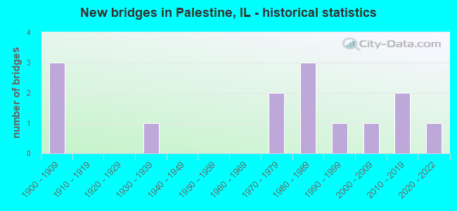
- New bridges - historical statistics
- 31900-1909
- 11930-1939
- 21970-1979
- 31980-1989
- 11990-1999
- 12000-2009
- 22010-2019
- 12020-2022

- Reconstructed bridges - Historical Statistics
- 11970-1979
- 01980-1989
- 01990-1999
- 02000-2009
- 12010-2019

- Bridge Condition - Deck
- 22.2%Very good
- 11.1%Good
- 44.4%Satisfactory
- 22.2%Fair

- Bridge Condition - Superstructure
- 22.2%Very good
- 22.2%Good
- 33.3%Satisfactory
- 11.1%Fair
- 11.1%Poor

- Bridge Condition - Substructure
- 44.4%Very good
- 55.6%Good

- Bridge Condition - Channel
- 28.6%Very good
- 28.6%Good
- 28.6%Satisfactory
- 14.3%Fair

- Bridge Condition - Culverts
- 20.0%Excellent
- 20.0%Very good
- 20.0%Good
- 20.0%Fair
- 20.0%Poor
Find on map >> Show street view
Structure Number: 170021, Location: .25 MI NE PALESTINE (Lat: 39.004486, Lng: -87.597953), Route carried "on" structure: County highway , Year Built: 1937, Status: Posted for load, Structure Length: 5.39m (17.68ft), Average Daily Traffic: 20 (year 2020), Truck Traffic: 5%, Average Future Daily Traffic: 25 (year 2032), Features Intersected: SUGAR CREEK, Facility Carried by Structure: SBI-163
Minimum Vertical Clearance: 30+ m (98+ ft), Kilometerpoint: 0.451, Lanes on structure: 2, Owner: State Highway Agency, Approaching Roadway Width: 12.2m (40.0ft), Material/Design: Steel continuous, Design/Construction: Stringer/Multi-beam, Number Of Spans In Main Unit: 3, Length of Maximum Span: 20.7m (67.9ft), Curb or Sidewalk Widths: Left: 0.6m (2.0ft), Right: 0.6m (2.0ft), Curb-To-Curb Width: 7.3m (24.0ft), Out-to-Out Width: 9.3m (30.5ft)
Condition: Deck: Fair, Superstructure: Poor, Substructure: Good, Channel: Satisfactory, Operating Rating: 33.7 metric tons, Method Used To Determine Operating Rating: Load Factor (LF) rating reported by rating factor (RF) method using MS18 loading, Inventory Rating: 18.1 metric tons, Method Used To Determine Inventory Rating: Load Factor (LF) rating reported by rating factor (RF) method using MS18 loading, Structural Evaluation: Meets minimum limits, Deck Geometry: Equal to present minimum criteria, Waterway Adequacy: Equal to present desirable criteria, Approach Roadway Alignment: Equal to present minimum criteria, Bridge Posting: Required (Relationship of Operating Rating to Maximum Legal Load: 20.0 - 29.9% below), Designated Inspection Frequency: Every 12 months, Inspection Date: May 2021, Deck Structure Type: Concrete Cast-file-Place
Find on map >> Show street view
Structure Number: 170035, Location: SW CL PALESTINE (Lat: 38.995236, Lng: -87.607761), Route carried "on" structure: State highway 33, Year Built: 2017, Status: Open, Structure Length: 5.81m (19.06ft), Average Daily Traffic: 950 (year 2021), Truck Traffic: 9%, Average Future Daily Traffic: 1,007 (year 2032), Design Load: HS 25 or greater, Features Intersected: LAMOTTE CREEK
Minimum Vertical Clearance: 30+ m (98+ ft), Kilometerpoint: 114.518, Lanes on structure: 2, Base Highway Network: Yes, Owner: State Highway Agency, Approaching Roadway Width: 6.7m (22.0ft), Material/Design: Steel continuous, Design/Construction: Stringer/Multi-beam, Number Of Spans In Main Unit: 3, Length of Maximum Span: 21.3m (69.9ft), Curb-To-Curb Width: 9.8m (32.2ft), Out-to-Out Width: 10.7m (35.1ft)
Condition: Deck: Very good, Superstructure: Very good, Substructure: Very good, Channel: Very good, Operating Rating: 82.9 metric tons, Method Used To Determine Operating Rating: Load and Resistance Factor Rating (LRFR) rating reported by rating factor(RF) method using HL-93 loadings, Inventory Rating: 63.8 metric tons, Method Used To Determine Inventory Rating: Load and Resistance Factor Rating (LRFR) rating reported by rating factor(RF) method using HL-93 loadings, Structural Evaluation: Equal to present desirable criteria, Deck Geometry: Equal to present minimum criteria, Waterway Adequacy: Equal to present desirable criteria, Approach Roadway Alignment: Equal to present desirable criteria, Designated Inspection Frequency: Every 48 months, Inspection Date: July 2019, Deck Structure Type: Concrete Cast-file-Place, Wearing Surface/Protective System: Deck Protection: Epoxy Coated Reinforcing
Find on map >> Show street view
Structure Number: 173047, Location: W OF PALESTINE (Lat: 38.999969, Lng: -87.625250), Route carried "on" structure: County highway , Year Built: 1976, Year Reconstructed: 2016, Status: Open, Structure Length: 1.88m (6.17ft), Average Daily Traffic: 900 (year 2020), Truck Traffic: 6%, Average Future Daily Traffic: 1,007 (year 2032), Design Load: HS 25 or greater, Features Intersected: Trib of Lamotte CK, Facility Carried by Structure: CH-4
Minimum Vertical Clearance: 30+ m (98+ ft), Kilometerpoint: 0.837, Lanes on structure: 2, Owner: County Highway Agency, Approaching Roadway Width: 7.3m (24.0ft), Skew: 3 degrees, Material/Design: Prestressed concrete, Design/Construction: Box Beam or Girders - Multiple, Number Of Spans In Main Unit: 2, Length of Maximum Span: 8.7m (28.5ft), Curb-To-Curb Width: 7.3m (24.0ft), Out-to-Out Width: 7.9m (25.9ft)
Condition: Deck: Satisfactory, Superstructure: Satisfactory, Substructure: Good, Channel: Good, Operating Rating: 39.5 metric tons, Method Used To Determine Operating Rating: Load and Resistance Factor Rating (LRFR) rating reported by rating factor(RF) method using HL-93 loadings, Inventory Rating: 30.5 metric tons, Method Used To Determine Inventory Rating: Load and Resistance Factor Rating (LRFR) rating reported by rating factor(RF) method using HL-93 loadings, Structural Evaluation: Equal to present minimum criteria, Deck Geometry: Meets minimum limits, Waterway Adequacy: Equal to present desirable criteria, Approach Roadway Alignment: Equal to present minimum criteria, Designated Inspection Frequency: Every 24 months, Inspection Date: December 2020, Deck Structure Type: Concrete Precast Panels, Wearing Surface/Protective System: Deck Protection: Epoxy Coated Reinforcing
Find on map >> Show street view
Structure Number: 173096, Location: N PALESTINE CL (Lat: 39.007708, Lng: -87.611997), Route carried "on" structure: County highway , Year Built: 1987, Status: Open, Structure Length: 3.14m (10.30ft), Average Daily Traffic: 550 (year 2020), Truck Traffic: 14%, Average Future Daily Traffic: 755 (year 2032), Design Load: HS 20, Features Intersected: SUGAR CREEK, Facility Carried by Structure: FAS-1694 (CH-5)
Minimum Vertical Clearance: 30+ m (98+ ft), Kilometerpoint: 13.373, Lanes on structure: 2, Owner: County Highway Agency, Approaching Roadway Width: 6.7m (22.0ft), Material/Design: Concrete continuous, Design/Construction: Slab, Number Of Spans In Main Unit: 3, Length of Maximum Span: 11.9m (39.0ft), Curb-To-Curb Width: 9.1m (29.9ft), Out-to-Out Width: 9.1m (29.9ft)
Condition: Deck: Very good, Superstructure: Very good, Substructure: Very good, Channel: Good, Operating Rating: 44.4 metric tons, Method Used To Determine Operating Rating: Assigned rating based on Load Factor Design (LFD) reported by rating factor (RF) using MS18 loading, Inventory Rating: 32.4 metric tons, Method Used To Determine Inventory Rating: Assigned rating based on Load Factor Design (LFD) reported by rating factor (RF) using MS18 loading, Structural Evaluation: Equal to present desirable criteria, Deck Geometry: Equal to present minimum criteria, Waterway Adequacy: Equal to present desirable criteria, Approach Roadway Alignment: Better than present minimum criteria, Designated Inspection Frequency: Every 48 months, Inspection Date: January 2019, Deck Structure Type: Concrete Cast-file-Place
Find on map >> Show street view
Structure Number: 173313, Location: 1.5 MI S BRISTOL (Lat: 38.958394, Lng: -87.575131), Route carried "on" structure: County highway , Year Built: 1909, Year Reconstructed: 1982, Status: Open, Structure Length: 1.34m (4.40ft), Average Daily Traffic: 50 (year 2020), Truck Traffic: 10%, Average Future Daily Traffic: 50 (year 2032), Design Load: HS 20, Features Intersected: NO BUSINESS CREEK, Facility Carried by Structure: TR-312
Minimum Vertical Clearance: 30+ m (98+ ft), Kilometerpoint: 2.929, Lanes on structure: 2, Owner: Town or Township Highway Agency, Approaching Roadway Width: 5.2m (17.1ft), Material/Design: Prestressed concrete, Design/Construction: Box Beam or Girders - Multiple, Number Of Spans In Main Unit: 1, Number Of Approach Spans: 2, Length of Maximum Span: 12.8m (42.0ft), Curb-To-Curb Width: 8.4m (27.6ft), Out-to-Out Width: 8.4m (27.6ft)
Condition: Deck: Good, Superstructure: Good, Substructure: Good, Channel: Satisfactory, Operating Rating: 62.5 metric tons, Method Used To Determine Operating Rating: Load Factor (LF) rating reported by rating factor (RF) method using MS18 loading, Inventory Rating: 37.6 metric tons, Method Used To Determine Inventory Rating: Load Factor (LF) rating reported by rating factor (RF) method using MS18 loading, Structural Evaluation: Better than present minimum criteria, Deck Geometry: Equal to present minimum criteria, Waterway Adequacy: Equal to present minimum criteria, Approach Roadway Alignment: Better than present minimum criteria, Designated Inspection Frequency: Every 24 months, Inspection Date: Febuary 2021, Deck Structure Type: Concrete Precast Panels, Wearing Surface/Protective System: Wearing Surface: Gravel
Find on map >> Show street view
Structure Number: 173319, Location: 2 MI NW PALESTINE (Lat: 39.021906, Lng: -87.633806), Route carried "on" structure: County highway , Year Built: 1981, Status: Open, Structure Length: 2.87m (9.42ft), Average Daily Traffic: 200 (year 2020), Truck Traffic: 5%, Average Future Daily Traffic: 277 (year 2032), Design Load: HS 20, Features Intersected: SUGAR CREEK, Facility Carried by Structure: TR-161
Minimum Vertical Clearance: 30+ m (98+ ft), Kilometerpoint: 4.409, Lanes on structure: 2, Owner: Town or Township Highway Agency, Approaching Roadway Width: 7.9m (25.9ft), Skew: 3 degrees, Material/Design: Concrete, Design/Construction: Channel Beam, Number Of Spans In Main Unit: 3, Length of Maximum Span: 10.7m (35.1ft), Curb-To-Curb Width: 8.0m (26.2ft), Out-to-Out Width: 8.0m (26.2ft)
Condition: Deck: Satisfactory, Superstructure: Good, Substructure: Good, Channel: Fair, Operating Rating: 44.4 metric tons, Method Used To Determine Operating Rating: Assigned rating based on Load Factor Design (LFD) reported by rating factor (RF) using MS18 loading, Inventory Rating: 32.4 metric tons, Method Used To Determine Inventory Rating: Assigned rating based on Load Factor Design (LFD) reported by rating factor (RF) using MS18 loading, Structural Evaluation: Better than present minimum criteria, Deck Geometry: Somewhat better than minimum adequacy, Waterway Adequacy: Equal to present desirable criteria, Approach Roadway Alignment: Equal to present minimum criteria, Designated Inspection Frequency: Every 48 months, Inspection Date: March 2019, Deck Structure Type: Concrete Precast Panels, Wearing Surface/Protective System: Wearing Surface: Gravel
Find on map >> Show street view
Structure Number: 17332, Location: 2.8 MI S PALESTINE (Lat: 38.956139, Lng: -87.627419), Route carried "on" structure: County highway , Year Built: 1983, Status: Open, Structure Length: 2.07m (6.79ft), Average Daily Traffic: 150 (year 2020), Truck Traffic: 7%, Average Future Daily Traffic: 126 (year 2032), Design Load: HS 20, Features Intersected: CREEK, Facility Carried by Structure: TR-215
Minimum Vertical Clearance: 30+ m (98+ ft), Kilometerpoint: 3.782, Lanes on structure: 2, Owner: Town or Township Highway Agency, Approaching Roadway Width: 7.3m (24.0ft), Skew: 2 degrees, Material/Design: Prestressed concrete, Design/Construction: Box Beam or Girders - Multiple, Number Of Spans In Main Unit: 1, Length of Maximum Span: 19.2m (63.0ft), Curb-To-Curb Width: 8.3m (27.2ft), Out-to-Out Width: 8.3m (27.2ft)
Condition: Deck: Satisfactory, Superstructure: Satisfactory, Substructure: Good, Channel: Good, Operating Rating: 44.4 metric tons, Method Used To Determine Operating Rating: Assigned rating based on Load Factor Design (LFD) reported by rating factor (RF) using MS18 loading, Inventory Rating: 32.4 metric tons, Method Used To Determine Inventory Rating: Assigned rating based on Load Factor Design (LFD) reported by rating factor (RF) using MS18 loading, Structural Evaluation: Equal to present minimum criteria, Deck Geometry: Somewhat better than minimum adequacy, Waterway Adequacy: Equal to present desirable criteria, Approach Roadway Alignment: Equal to present desirable criteria, Designated Inspection Frequency: Every 24 months, Inspection Date: March 2020, Deck Structure Type: Concrete Precast Panels
Find on map >> Show street view
Structure Number: 173325, Location: 0.5 MI SE PALESTINE (Lat: 38.991339, Lng: -87.595192), Route carried "on" structure: County highway , Year Built: 2009, Status: Open, Structure Length: 4.80m (15.75ft), Average Daily Traffic: 250 (year 2020), Truck Traffic: 4%, Average Future Daily Traffic: 403 (year 2032), Design Load: HS 20, Features Intersected: LAMOTTE CREEK, Facility Carried by Structure: TR 175A
Minimum Vertical Clearance: 30+ m (98+ ft), Kilometerpoint: 1.030, Lanes on structure: 2, Owner: Town or Township Highway Agency, Approaching Roadway Width: 6.1m (20.0ft), Skew: 4 degrees, Material/Design: Prestressed concrete, Design/Construction: Box Beam or Girders - Multiple, Number Of Spans In Main Unit: 3, Length of Maximum Span: 16.9m (55.4ft), Curb-To-Curb Width: 8.5m (27.9ft), Out-to-Out Width: 8.5m (27.9ft)
Condition: Deck: Fair, Superstructure: Fair, Substructure: Very good, Channel: Good, Operating Rating: 44.1 metric tons, Method Used To Determine Operating Rating: Assigned rating based on Load Factor Design (LFD) reported by rating factor (RF) using MS18 loading, Inventory Rating: 32.4 metric tons, Method Used To Determine Inventory Rating: Assigned rating based on Load Factor Design (LFD) reported by rating factor (RF) using MS18 loading, Structural Evaluation: Somewhat better than minimum adequacy, Deck Geometry: Equal to present minimum criteria, Waterway Adequacy: Equal to present desirable criteria, Approach Roadway Alignment: Equal to present desirable criteria, Designated Inspection Frequency: Every 24 months, Inspection Date: January 2021, Deck Structure Type: Concrete Precast Panels
Find on map >> Show street view
Structure Number: 173326, Location: 1 Mi. E Palastine (Lat: 39.006350, Lng: -87.583906), Route carried "on" structure: County highway , Year Built: 2017, Status: Open, Structure Length: 1.03m (3.38ft), Average Daily Traffic: 25 (year 2020), Truck Traffic: 4%, Average Future Daily Traffic: 25 (year 2032), Design Load: HS 25 or greater, Features Intersected: Minnow Slough, Facility Carried by Structure: TR 169A
Minimum Vertical Clearance: 30+ m (98+ ft), Kilometerpoint: 0.901, Lanes on structure: 2, Owner: Town or Township Highway Agency, Approaching Roadway Width: 6.7m (22.0ft), Material/Design: Aluminum, Iron, Design/Construction: Culvert, Number Of Spans In Main Unit: 1, Length of Maximum Span: 10.3m (33.8ft), Curb-To-Curb Width: 5.5m (18.0ft), Out-to-Out Width: 6.7m (22.0ft)
Condition: Channel: Very good, Culverts: Very good, Operating Rating: 42.1 metric tons, Method Used To Determine Operating Rating: Assigned ratings based on Load and Resistance Factor Design (LRFD) reported by rating factor (RF) using HL93 loadings, Inventory Rating: 32.4 metric tons, Method Used To Determine Inventory Rating: Assigned ratings based on Load and Resistance Factor Design (LRFD) reported by rating factor (RF) using HL93 loadings, Structural Evaluation: Equal to present desirable criteria, Deck Geometry: Meets minimum limits, Waterway Adequacy: Somewhat better than minimum adequacy, Approach Roadway Alignment: Better than present minimum criteria, Designated Inspection Frequency: Every 24 months, Inspection Date: October 2021
Find on map >> Show street view
Structure Number: 173327, Location: 1.5 MI NE PALESTINE (Lat: 39.021083, Lng: -87.583328), Route carried "on" structure: County highway , Year Built: 2021, Status: Open, Structure Length: 0.99m (3.25ft), Average Daily Traffic: 20 (year 2020), Truck Traffic: 5%, Average Future Daily Traffic: 76 (year 2032), Design Load: HS 25 or greater, Features Intersected: MINNOW SLOUGH, Facility Carried by Structure: TR 163
Minimum Vertical Clearance: 30+ m (98+ ft), Kilometerpoint: 2.607, Lanes on structure: 1, Owner: Town or Township Highway Agency, Approaching Roadway Width: 6.1m (20.0ft), Material/Design: Aluminum, Iron, Design/Construction: Culvert, Number Of Spans In Main Unit: 1, Length of Maximum Span: 0.0m, Curb-To-Curb Width: 6.1m (20.0ft)
Condition: Channel: Very good, Culverts: Excellent, Deck Geometry: Somewhat better than minimum adequacy, Waterway Adequacy: Equal to present desirable criteria, Approach Roadway Alignment: Better than present minimum criteria, Designated Inspection Frequency: Every 24 months, Inspection Date: October 2021
Find on map >> Show street view
Structure Number: 173632, Location: 4 MI N HEATHSVILLE (Lat: 38.957961, Lng: -87.571028), Route carried "on" structure: County highway , Year Built: 1996, Status: Open, Structure Length: 1.88m (6.17ft), Average Daily Traffic: 20 (year 2020), Truck Traffic: 5%, Average Future Daily Traffic: 50 (year 2032), Design Load: HS 20, Features Intersected: NO BUSINESS CREEK, Facility Carried by Structure: TR 217
Minimum Vertical Clearance: 30+ m (98+ ft), Kilometerpoint: 0.354, Lanes on structure: 2, Owner: Town or Township Highway Agency, Approaching Roadway Width: 8.5m (27.9ft), Skew: 3 degrees, Material/Design: Prestressed concrete, Design/Construction: Box Beam or Girders - Multiple, Number Of Spans In Main Unit: 1, Length of Maximum Span: 17.9m (58.7ft), Curb-To-Curb Width: 8.5m (27.9ft), Out-to-Out Width: 8.5m (27.9ft)
Condition: Deck: Satisfactory, Superstructure: Satisfactory, Substructure: Very good, Channel: Very good, Operating Rating: 44.1 metric tons, Method Used To Determine Operating Rating: Assigned rating based on Load Factor Design (LFD) reported by rating factor (RF) using MS18 loading, Inventory Rating: 32.4 metric tons, Method Used To Determine Inventory Rating: Assigned rating based on Load Factor Design (LFD) reported by rating factor (RF) using MS18 loading, Structural Evaluation: Equal to present minimum criteria, Deck Geometry: Better than present minimum criteria, Waterway Adequacy: Equal to present desirable criteria, Approach Roadway Alignment: Equal to present desirable criteria, Designated Inspection Frequency: Every 24 months, Inspection Date: April 2020, Deck Structure Type: Concrete Precast Panels
Find on map >> Show street view
Structure Number: 175007, Location: 1.25 MI SW PALESTINE (Lat: 38.979589, Lng: -87.632183), Route carried "on" structure: County highway , Year Built: 1971, Status: Open, Structure Length: 1.71m (5.61ft), Average Daily Traffic: 200 (year 2020), Truck Traffic: 6%, Average Future Daily Traffic: 277 (year 2032), Design Load: H 15, Features Intersected: LAMOTTE CREEK, Facility Carried by Structure: CH-4
Minimum Vertical Clearance: 30+ m (98+ ft), Kilometerpoint: 3.653, Lanes on structure: 2, Owner: County Highway Agency, Approaching Roadway Width: 6.7m (22.0ft), Material/Design: Steel, Design/Construction: Culvert, Number Of Spans In Main Unit: 3, Length of Maximum Span: 6.0m (19.7ft)
Condition: Channel: Satisfactory, Culverts: Good, Operating Rating: 40.5 metric tons, Method Used To Determine Operating Rating: Field evaluation and documented engineering judgment, Inventory Rating: 24.3 metric tons, Method Used To Determine Inventory Rating: Field evaluation and documented engineering judgment, Structural Evaluation: Equal to present minimum criteria, Waterway Adequacy: Better than present minimum criteria, Approach Roadway Alignment: Equal to present desirable criteria, Designated Inspection Frequency: Every 24 months, Inspection Date: January 2021
Find on map >> Show street view
Structure Number: 175011, Location: 3.5 MI SE PALESTINE (Lat: 38.959628, Lng: -87.584944), Route carried "on" structure: County highway , Year Built: 1909, Status: Open, Structure Length: 1.08m (3.54ft), Average Daily Traffic: 75 (year 2020), Truck Traffic: 3%, Average Future Daily Traffic: 101 (year 2032), Features Intersected: CREEK, Facility Carried by Structure: TR-310
Minimum Vertical Clearance: 30+ m (98+ ft), Kilometerpoint: 0.418, Lanes on structure: 2, Owner: Town or Township Highway Agency, Approaching Roadway Width: 6.7m (22.0ft), Material/Design: Steel, Design/Construction: Culvert, Number Of Spans In Main Unit: 2, Length of Maximum Span: 4.8m (15.7ft)
Condition: Channel: Fair, Culverts: Poor, Operating Rating: 48.3 metric tons, Method Used To Determine Operating Rating: Load Factor (LF) rating reported by rating factor (RF) method using MS18 loading, Inventory Rating: 29.2 metric tons, Method Used To Determine Inventory Rating: Load Factor (LF) rating reported by rating factor (RF) method using MS18 loading, Structural Evaluation: Meets minimum limits, Waterway Adequacy: Better than present minimum criteria, Approach Roadway Alignment: Equal to present minimum criteria, Designated Inspection Frequency: Every 24 months, Inspection Date: January 2021
Find on map >> Show street view
Structure Number: 1783, Location: MP 19.08 (Lat: 38.996442, Lng: -87.609372), Route carried "on" structure: State highway 33, Year Built: 1909, Status: Open, Structure Length: 0.80m (2.62ft), Average Daily Traffic: 950 (year 2021), Truck Traffic: 9%, Average Future Daily Traffic: 1,007 (year 2032), Features Intersected: STREAM
Minimum Vertical Clearance: 30+ m (98+ ft), Kilometerpoint: 114.325, Lanes on structure: 2, Base Highway Network: Yes, Owner: State Highway Agency, Approaching Roadway Width: 6.7m (22.0ft), Skew: 4 degrees, Material/Design: Concrete, Design/Construction: Culvert, Number Of Spans In Main Unit: 2, Length of Maximum Span: 3.9m (12.8ft)
Condition: Channel: Satisfactory, Culverts: Fair, Operating Rating: 89.1 metric tons, Method Used To Determine Operating Rating: Load Factor (LF) rating reported by rating factor (RF) method using MS18 loading, Inventory Rating: 89.1 metric tons, Method Used To Determine Inventory Rating: Load Factor (LF) rating reported by rating factor (RF) method using MS18 loading, Structural Evaluation: Somewhat better than minimum adequacy, Waterway Adequacy: Equal to present desirable criteria, Approach Roadway Alignment: Equal to present desirable criteria, Designated Inspection Frequency: Every 24 months, Inspection Date: October 2021