Bridge Statistics for Pacific City, Oregon (OR)
Condition, Traffic, Stress, Structural Evaluation, Project Costs
- National Bridge Inventory (NBI) Statistics
- 11Number of bridges
- 210ft / 64.5mTotal length
- $472,000Total costs
- 16,500Total average daily traffic
- 2,224Total average daily truck traffic
- 20,021Total future (year 2025) average daily traffic
- National Bridge Inventory (NBI) Registered Bridges for Pacific City
- No street view available for this location
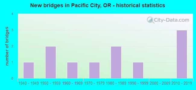
- New bridges - historical statistics
- 11940-1949
- 21950-1959
- 11960-1969
- 11970-1979
- 21980-1989
- 11990-1999
- 32010-2019


- Bridge Condition - Deck
- 18.2%Very good
- 36.4%Good
- 36.4%Satisfactory
- 9.1%Fair

- Bridge Condition - Superstructure
- 18.2%Very good
- 45.5%Good
- 27.3%Satisfactory
- 9.1%Fair

- Bridge Condition - Substructure
- 18.2%Very good
- 18.2%Good
- 36.4%Satisfactory
- 27.3%Fair

- Bridge Condition - Channel
- 18.2%Very good
- 36.4%Good
- 36.4%Satisfactory
- 9.1%Fair
Find on map >> Show street view
Structure Number: 1372A871 00007, Location: AT WOODS (Lat: 45.211825, Lng: -123.954028), Route carried "on" structure: County highway A0729, Year Built: 1986, Status: Open, Structure Length: 8.96m (29.40ft), Average Daily Traffic: 1,380 (year 2020), Truck Traffic: 15%, Average Future Daily Traffic: 1,604 (year 2025), Design Load: HS 20, Features Intersected: NESTUCCA RIVER, Facility Carried by Structure: FERRY ST
Minimum Vertical Clearance: 30+ m (98+ ft), Kilometerpoint: 20.616, Lanes on structure: 2, Owner: County Highway Agency, Approaching Roadway Width: 10.7m (35.1ft), Navigation Control: Yes ( Vertical Clearance: 3.7m (12.1ft), Horizontal Clearance: 20.4m (66.9ft)), Material/Design: Prestressed concrete, Design/Construction: Slab, Number Of Spans In Main Unit: 5, Length of Maximum Span: 20.1m (65.9ft), Curb-To-Curb Width: 10.7m (35.1ft), Out-to-Out Width: 11.6m (38.1ft)
Condition: Deck: Good, Superstructure: Good, Substructure: Fair, Channel: Satisfactory, Operating Rating: 39.9 metric tons, Method Used To Determine Operating Rating: Load Factor (LF), Inventory Rating: 23.6 metric tons, Method Used To Determine Inventory Rating: Load Factor (LF), Structural Evaluation: Somewhat better than minimum adequacy, Deck Geometry: Equal to present minimum criteria, Waterway Adequacy: Equal to present desirable criteria, Approach Roadway Alignment: Equal to present minimum criteria, Designated Inspection Frequency: Every 24 months, Underwater Inspection Frequency: Every 36 months, Inspection Date: June 2021, Underwater Inspection Date: Febuary 2021, Deck Structure Type: Other, Wearing Surface/Protective System: Wearing Surface: Bituminous
Find on map >> Show street view
Structure Number: 1863 130 0036, Location: 036 MI E HWY 9 JCT (Lat: 45.128100, Lng: -123.890100), Route carried "on" structure: State highway 130, Year Built: 1942, Status: Posted for load, Structure Length: 2.16m (7.09ft), Average Daily Traffic: 933 (year 2020), Truck Traffic: 15%, Average Future Daily Traffic: 1,400 (year 2040), Design Load: HS 20, Features Intersected: Squaw Creek
Minimum Vertical Clearance: 30+ m (98+ ft), Kilometerpoint: 5.794, Lanes on structure: 2, Owner: State Highway Agency, Approaching Roadway Width: 7.6m (24.9ft), Material/Design: Wood or Timber, Design/Construction: Stringer/Multi-beam, Number Of Spans In Main Unit: 3, Length of Maximum Span: 8.8m (28.9ft), Curb-To-Curb Width: 7.5m (24.6ft), Out-to-Out Width: 7.9m (25.9ft)
Condition: Deck: Good, Superstructure: Satisfactory, Substructure: Satisfactory, Channel: Satisfactory, Operating Rating: 19.8 metric tons, Method Used To Determine Operating Rating: Load and Resistance Factor Rating (LRFR) rating reported by rating factor(RF) method using HL-93 loadings, Inventory Rating: 15.2 metric tons, Method Used To Determine Inventory Rating: Load and Resistance Factor Rating (LRFR) rating reported by rating factor(RF) method using HL-93 loadings, Structural Evaluation: Meets minimum limits, Deck Geometry: Meets minimum limits, Waterway Adequacy: Equal to present desirable criteria, Approach Roadway Alignment: Equal to present desirable criteria, Bridge Posting: Required (Relationship of Operating Rating to Maximum Legal Load: 20.0 - 29.9% below), Length Of Structure Improvement: 2.80m (9.19ft), Designated Inspection Frequency: Every 24 months, Inspection Date: Febuary 2021, Bridge Improvement Cost: $295,000, Roadway Improvement Cost: $30,000, Total Project Cost: $472,000, Deck Structure Type: Wood or Timber, Wearing Surface/Protective System: Wearing Surface: Bituminous
Find on map >> Show street view
Structure Number: 1864 130 00323, Location: 032 MI E HWY 9 JCT (Lat: 45.132811, Lng: -123.893728), Route carried "on" structure: State highway 130, Year Built: 1957, Status: Open, Structure Length: 1.92m (6.30ft), Average Daily Traffic: 951 (year 2020), Truck Traffic: 15%, Average Future Daily Traffic: 1,400 (year 2040), Design Load: HS 20, Features Intersected: Panther Creek
Minimum Vertical Clearance: 30+ m (98+ ft), Kilometerpoint: 5.198, Lanes on structure: 2, Owner: State Highway Agency, Approaching Roadway Width: 7.6m (24.9ft), Material/Design: Wood or Timber, Design/Construction: Stringer/Multi-beam, Number Of Spans In Main Unit: 3, Length of Maximum Span: 7.6m (24.9ft), Curb-To-Curb Width: 7.6m (24.9ft), Out-to-Out Width: 8.2m (26.9ft)
Condition: Deck: Satisfactory, Superstructure: Good, Substructure: Satisfactory, Channel: Satisfactory, Operating Rating: 18.5 metric tons, Method Used To Determine Operating Rating: Load and Resistance Factor Rating (LRFR) rating reported by rating factor(RF) method using HL-93 loadings, Inventory Rating: 14.3 metric tons, Method Used To Determine Inventory Rating: Load and Resistance Factor Rating (LRFR) rating reported by rating factor(RF) method using HL-93 loadings, Structural Evaluation: Meets minimum limits, Deck Geometry: Meets minimum limits, Waterway Adequacy: Equal to present desirable criteria, Approach Roadway Alignment: Equal to present desirable criteria, Bridge Posting: Required (Relationship of Operating Rating to Maximum Legal Load: 20.0 - 29.9% below), Designated Inspection Frequency: Every 24 months, Inspection Date: Febuary 2021, Deck Structure Type: Wood or Timber, Wearing Surface/Protective System: Wearing Surface: Bituminous
Find on map >> Show street view
Structure Number: 2508A009 09185, Location: 00.4 MI S HWY 130 JCT (Lat: 45.161208, Lng: -123.937739), Route carried "on" structure: US 101, Year Built: 1980, Status: Open, Structure Length: 18.87m (61.91ft), Average Daily Traffic: 4,012 (year 2020), Truck Traffic: 17%, Average Future Daily Traffic: 4,500 (year 2040), Design Load: HS 20, Features Intersected: Little Nestucca River
Minimum Vertical Clearance: 30+ m (98+ ft), Kilometerpoint: 147.722, Lanes on structure: 2, Base Highway Network: Yes, Owner: State Highway Agency, Approaching Roadway Width: 12.2m (40.0ft), Skew: 3 degrees, Material/Design: Prestressed concrete, Design/Construction: Stringer/Multi-beam, Number Of Spans In Main Unit: 5, Length of Maximum Span: 40.5m (132.9ft), Curb-To-Curb Width: 12.2m (40.0ft), Out-to-Out Width: 13.0m (42.7ft)
Condition: Deck: Satisfactory, Superstructure: Good, Substructure: Fair, Channel: Good, Operating Rating: 24.6 metric tons, Method Used To Determine Operating Rating: Load and Resistance Factor Rating (LRFR) rating reported by rating factor(RF) method using HL-93 loadings, Inventory Rating: 19.1 metric tons, Method Used To Determine Inventory Rating: Load and Resistance Factor Rating (LRFR) rating reported by rating factor(RF) method using HL-93 loadings, Structural Evaluation: Somewhat better than minimum adequacy, Deck Geometry: Equal to present minimum criteria, Waterway Adequacy: Equal to present desirable criteria, Approach Roadway Alignment: Equal to present desirable criteria, Designated Inspection Frequency: Every 24 months, Underwater Inspection Frequency: Every 36 months, Inspection Date: January 2021, Underwater Inspection Date: June 2021, Deck Structure Type: Concrete Cast-file-Place, Wearing Surface/Protective System: Wearing Surface: Epoxy Overlay, Deck Protection: Epoxy Coated Reinforcing
Find on map >> Show street view
Structure Number: 4691A130 00127, Location: 013 MI E HWY 9 JCT (Lat: 45.152781, Lng: -123.913931), Route carried "on" structure: State highway 130, Year Built: 1956, Status: Open, Structure Length: 7.99m (26.21ft), Average Daily Traffic: 1,178 (year 2020), Truck Traffic: 15%, Average Future Daily Traffic: 1,700 (year 2040), Design Load: HS 20, Features Intersected: Little Nestucca River
Minimum Vertical Clearance: 30+ m (98+ ft), Kilometerpoint: 2.044, Lanes on structure: 2, Owner: State Highway Agency, Approaching Roadway Width: 7.9m (25.9ft), Material/Design: Concrete continuous, Design/Construction: Tee Beam, Number Of Spans In Main Unit: 5, Length of Maximum Span: 21.3m (69.9ft), Curb-To-Curb Width: 7.9m (25.9ft), Out-to-Out Width: 9.4m (30.8ft)
Condition: Deck: Satisfactory, Superstructure: Satisfactory, Substructure: Satisfactory, Channel: Satisfactory, Operating Rating: 35.0 metric tons, Method Used To Determine Operating Rating: Load and Resistance Factor Rating (LRFR) rating reported by rating factor(RF) method using HL-93 loadings, Inventory Rating: 26.9 metric tons, Method Used To Determine Inventory Rating: Load and Resistance Factor Rating (LRFR) rating reported by rating factor(RF) method using HL-93 loadings, Structural Evaluation: Equal to present minimum criteria, Deck Geometry: Meets minimum limits, Waterway Adequacy: Equal to present desirable criteria, Approach Roadway Alignment: Equal to present desirable criteria, Designated Inspection Frequency: Every 24 months, Underwater Inspection Frequency: Every 60 months, Inspection Date: Febuary 2021, Underwater Inspection Date: April 2018, Deck Structure Type: Concrete Cast-file-Place, Wearing Surface/Protective System: Wearing Surface: Epoxy Overlay
Find on map >> Show street view
Structure Number: 11366A915 00288, Location: PACIFIC CITY (Lat: 45.202139, Lng: -123.964861), Route carried "on" structure: County highway A0720, Year Built: 1973, Status: Open, Structure Length: 13.05m (42.81ft), Average Daily Traffic: 3,489 (year 2020), Truck Traffic: 5%, Average Future Daily Traffic: 4,055 (year 2025), Design Load: HS 20, Features Intersected: NESTUCCA RIVER, Facility Carried by Structure: PACIFIC AVE
Minimum Vertical Clearance: 30+ m (98+ ft), Kilometerpoint: 0.193, Lanes on structure: 2, Owner: County Highway Agency, Approaching Roadway Width: 9.8m (32.2ft), Navigation Control: Yes ( Vertical Clearance: 4.6m (15.1ft), Horizontal Clearance: 29.3m (96.1ft)), Material/Design: Prestressed concrete, Design/Construction: Box Beam or Girders - Multiple, Number Of Spans In Main Unit: 1, Number Of Approach Spans: 7, Length of Maximum Span: 29.3m (96.1ft), Curb or Sidewalk Widths: Left: 1.5m (4.9ft), Right: 0.0m, Curb-To-Curb Width: 9.8m (32.2ft), Out-to-Out Width: 12.4m (40.7ft)
Condition: Deck: Satisfactory, Superstructure: Fair, Substructure: Satisfactory, Channel: Fair, Operating Rating: 63.5 metric tons, Method Used To Determine Operating Rating: Allowable Stress (AS), Inventory Rating: 38.1 metric tons, Method Used To Determine Inventory Rating: Allowable Stress (AS), Structural Evaluation: Somewhat better than minimum adequacy, Deck Geometry: Meets minimum limits, Waterway Adequacy: Equal to present desirable criteria, Approach Roadway Alignment: Equal to present minimum criteria, Designated Inspection Frequency: Every 24 months, Underwater Inspection Frequency: Every 60 months, Inspection Date: June 2021, Underwater Inspection Date: June 2021, Deck Structure Type: Other, Wearing Surface/Protective System: Wearing Surface: Bituminous
Find on map >> Show street view
Structure Number: 11386 887 00175, Location: 0.05 MI S PACIFIC CITY (Lat: 45.195969, Lng: -123.956850), Route carried "on" structure: County highway A0720, Year Built: 1990, Status: Open, Structure Length: 2.16m (7.09ft), Average Daily Traffic: 4,179 (year 2020), Truck Traffic: 15%, Average Future Daily Traffic: 4,929 (year 2025), Design Load: HS 25 or greater, Features Intersected: SLOUGH, Facility Carried by Structure: BROOTEN RD
Minimum Vertical Clearance: 30+ m (98+ ft), Kilometerpoint: 6.695, Lanes on structure: 2, Owner: County Highway Agency, Approaching Roadway Width: 9.1m (29.9ft), Skew: 2 degrees, Material/Design: Prestressed concrete, Design/Construction: Slab, Number Of Spans In Main Unit: 1, Length of Maximum Span: 20.7m (67.9ft), Curb-To-Curb Width: 9.1m (29.9ft), Out-to-Out Width: 9.8m (32.2ft)
Condition: Deck: Good, Superstructure: Good, Substructure: Good, Channel: Good, Operating Rating: 57.2 metric tons, Method Used To Determine Operating Rating: Load Factor (LF), Inventory Rating: 34.5 metric tons, Method Used To Determine Inventory Rating: Load Factor (LF), Structural Evaluation: Better than present minimum criteria, Deck Geometry: Meets minimum limits, Waterway Adequacy: Equal to present desirable criteria, Approach Roadway Alignment: Equal to present desirable criteria, Designated Inspection Frequency: Every 24 months, Inspection Date: June 2021, Deck Structure Type: Other, Wearing Surface/Protective System: Wearing Surface: Bituminous, Membrane: Preformed Fabric, Deck Protection: Epoxy Coated Reinforcing
Find on map >> Show street view
Structure Number: 22465 000 00021, Location: MP 2.1 (Lat: 45.202417, Lng: -123.947972), Route carried "on" structure: County highway C0000, Year Built: 2017, Status: Open, Structure Length: 2.56m (8.40ft), Average Daily Traffic: 100 (year 2021), Truck Traffic: 10%, Average Future Daily Traffic: 120 (year 2041), Design Load: HL 93, Features Intersected: Nestucca River, Facility Carried by Structure: Resort Drive
Minimum Vertical Clearance: 30+ m (98+ ft), Kilometerpoint: 1.497, Lanes on structure: 2, Owner: County Highway Agency, Approaching Roadway Width: 4.6m (15.1ft), Material/Design: Prestressed concrete, Design/Construction: Box Beam or Girders - Multiple, Number Of Spans In Main Unit: 1, Length of Maximum Span: 24.4m (80.1ft), Curb-To-Curb Width: 7.3m (24.0ft), Out-to-Out Width: 4.9m (16.1ft)
Condition: Deck: Very good, Superstructure: Very good, Substructure: Very good, Channel: Very good, Operating Rating: 52.5 metric tons, Method Used To Determine Operating Rating: Load and Resistance Factor Rating (LRFR) rating reported by rating factor(RF) method using HL-93 loadings, Inventory Rating: 40.5 metric tons, Method Used To Determine Inventory Rating: Load and Resistance Factor Rating (LRFR) rating reported by rating factor(RF) method using HL-93 loadings, Structural Evaluation: Equal to present desirable criteria, Deck Geometry: Equal to present minimum criteria, Waterway Adequacy: Equal to present desirable criteria, Approach Roadway Alignment: Equal to present desirable criteria, Designated Inspection Frequency: Every 24 months, Inspection Date: January 2022, Deck Structure Type: Other, Wearing Surface/Protective System: Wearing Surface: Bituminous, Membrane: Epoxy
Find on map >> Show street view
Structure Number: 22471 000 00067, Location: Mp 0.67 Meda Loop Rd (Lat: 45.142500, Lng: -123.920278), Route carried "on" structure: County highway C000, Year Built: 2015, Status: Open, Structure Length: 0.79m (2.59ft), Average Daily Traffic: 120 (year 2020), Truck Traffic: 20%, Average Future Daily Traffic: 130 (year 2025), Design Load: HL 93, Features Intersected: Bower Creek, Facility Carried by Structure: Meda Loop
Minimum Vertical Clearance: 30+ m (98+ ft), Kilometerpoint: 1.078, Lanes on structure: 2, Owner: County Highway Agency, Approaching Roadway Width: 4.6m (15.1ft), Material/Design: Prestressed concrete, Design/Construction: Slab, Number Of Spans In Main Unit: 1, Length of Maximum Span: 7.9m (25.9ft), Curb or Sidewalk Widths: Left: 0.2m (0.7ft), Right: 0.2m (0.7ft), Curb-To-Curb Width: 5.8m (19.0ft), Out-to-Out Width: 6.1m (20.0ft)
Condition: Deck: Very good, Superstructure: Very good, Substructure: Good, Channel: Good, Operating Rating: 23.0 metric tons, Method Used To Determine Operating Rating: Load and Resistance Factor Rating (LRFR) rating reported by rating factor(RF) method using HL-93 loadings, Inventory Rating: 17.8 metric tons, Method Used To Determine Inventory Rating: Load and Resistance Factor Rating (LRFR) rating reported by rating factor(RF) method using HL-93 loadings, Structural Evaluation: Somewhat better than minimum adequacy, Deck Geometry: High priority of corrective action, Waterway Adequacy: Equal to present minimum criteria, Approach Roadway Alignment: Equal to present desirable criteria, Designated Inspection Frequency: Every 24 months, Inspection Date: June 2020, Deck Structure Type: Concrete Precast Panels, Wearing Surface/Protective System: Wearing Surface: Bituminous
Find on map >> Show street view
Structure Number: 22545 874 0001, Location: AT ENT WHALEN ISLAND PARK (Lat: 45.273417, Lng: -123.947000), Route carried "on" structure: County highway C0874, Year Built: 2018, Status: Open, Structure Length: 2.38m (7.81ft), Average Daily Traffic: 84 (year 2020), Average Future Daily Traffic: 99 (year 2025), Design Load: HL 93, Features Intersected: SAND LAKE, Facility Carried by Structure: WHALEN ISLAND ROAD
Minimum Vertical Clearance: 30+ m (98+ ft), Kilometerpoint: 0.156, Lanes on structure: 2, Owner: County Highway Agency, Approaching Roadway Width: 6.7m (22.0ft), Material/Design: Prestressed concrete, Design/Construction: Slab, Number Of Spans In Main Unit: 1, Length of Maximum Span: 23.8m (78.1ft), Curb-To-Curb Width: 9.5m (31.2ft), Out-to-Out Width: 10.3m (33.8ft)
Condition: Deck: Good, Superstructure: Good, Substructure: Very good, Channel: Very good, Operating Rating: 55.1 metric tons, Method Used To Determine Operating Rating: Load and Resistance Factor Rating (LRFR) rating reported by rating factor(RF) method using HL-93 loadings, Inventory Rating: 42.4 metric tons, Method Used To Determine Inventory Rating: Load and Resistance Factor Rating (LRFR) rating reported by rating factor(RF) method using HL-93 loadings, Structural Evaluation: Better than present minimum criteria, Deck Geometry: Better than present minimum criteria, Waterway Adequacy: Equal to present desirable criteria, Approach Roadway Alignment: Equal to present desirable criteria, Designated Inspection Frequency: Every 24 months, Inspection Date: June 2021, Deck Structure Type: Concrete Precast Panels, Wearing Surface/Protective System: Wearing Surface: Bituminous
Find on map >> Show street view
Structure Number: 57C51 875 00005, Location: 1.7 MI W OF CLOVERDALE (Lat: 45.201697, Lng: -123.924908), Route carried "on" structure: County highway C0875, Year Built: 1964, Status: Posted for load, Structure Length: 3.63m (11.91ft), Average Daily Traffic: 74 (year 2020), Truck Traffic: 60%, Average Future Daily Traffic: 84 (year 2025), Design Load: HS 20, Features Intersected: SLOUGH, Facility Carried by Structure: LEARNED ROAD
Minimum Vertical Clearance: 30+ m (98+ ft), Kilometerpoint: 0.032, Lanes on structure: 1, Owner: County Highway Agency, Approaching Roadway Width: 4.6m (15.1ft), Material/Design: Wood or Timber, Design/Construction: Stringer/Multi-beam, Number Of Spans In Main Unit: 1, Number Of Approach Spans: 4, Length of Maximum Span: 12.8m (42.0ft), Curb-To-Curb Width: 4.3m (14.1ft), Out-to-Out Width: 4.9m (16.1ft)
Condition: Deck: Fair, Superstructure: Satisfactory, Substructure: Fair, Channel: Good, Operating Rating: 16.5 metric tons, Method Used To Determine Operating Rating: Load and Resistance Factor Rating (LRFR) rating reported by rating factor(RF) method using HL-93 loadings, Inventory Rating: 12.6 metric tons, Method Used To Determine Inventory Rating: Load and Resistance Factor Rating (LRFR) rating reported by rating factor(RF) method using HL-93 loadings, Structural Evaluation: Meets minimum limits, Deck Geometry: Equal to present minimum criteria, Waterway Adequacy: Equal to present desirable criteria, Approach Roadway Alignment: Equal to present desirable criteria, Bridge Posting: Required (Relationship of Operating Rating to Maximum Legal Load: > 39.9% below), Designated Inspection Frequency: Every 12 months, Underwater Inspection Frequency: Every 60 months, Inspection Date: June 2021, Underwater Inspection Date: June 2020, Deck Structure Type: Wood or Timber, Wearing Surface/Protective System: Wearing Surface: Bituminous