Bridge Statistics for Oxford, Nebraska (NE)
Condition, Traffic, Stress, Structural Evaluation, Project Costs
- National Bridge Inventory (NBI) Statistics
- 26Number of bridges
- 177ft / 53.6mTotal length
- 19,230Total average daily traffic
- 2,249Total average daily truck traffic
- National Bridge Inventory (NBI) Registered Bridges for Oxford
- No street view available for this location
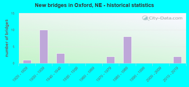
- New bridges - historical statistics
- 11920-1929
- 101930-1939
- 31940-1949
- 21970-1979
- 81980-1989
- 22010-2019

- Reconstructed bridges - Historical Statistics
- 11950-1959
- 01960-1969
- 21970-1979
- 01980-1989
- 11990-1999


- Bridge Condition - Deck
- 14.3%Excellent
- 7.1%Very good
- 21.4%Good
- 21.4%Satisfactory
- 28.6%Fair
- 7.1%Poor

- Bridge Condition - Superstructure
- 7.1%Excellent
- 21.4%Very good
- 28.6%Good
- 14.3%Satisfactory
- 28.6%Fair

- Bridge Condition - Substructure
- 21.4%Very good
- 21.4%Good
- 21.4%Satisfactory
- 28.6%Fair
- 7.1%Poor

- Bridge Condition - Channel
- 16.0%Excellent
- 36.0%Very good
- 28.0%Good
- 8.0%Satisfactory
- 8.0%Fair
- 4.0%Poor

- Bridge Condition - Culverts
- 18.2%Very good
- 63.6%Good
- 18.2%Satisfactory
Find on map >> Show street view
Structure Number: C003315935, Location: .2W OF OXFORD (Lat: 40.254100, Lng: -99.649300), Route carried "on" structure: County highway 159, Year Built: 1985, Status: Open, Structure Length: 0.79m (2.59ft), Average Daily Traffic: 15 (year 2003), Average Future Daily Traffic: 25 (year 2042), Features Intersected: CAMBRIDGE-OXFORD-ORLEANS, Facility Carried by Structure: COUNTY HIGHWAY
Minimum Vertical Clearance: 30+ m (98+ ft), Kilometerpoint: 0.000, Lanes on structure: 2, Owner: Local Agency, Approaching Roadway Width: 6.4m (21.0ft), Skew: 2 degrees, Material/Design: Prestressed concrete, Design/Construction: Tee Beam, Number Of Spans In Main Unit: 1, Length of Maximum Span: 7.3m (24.0ft), Curb-To-Curb Width: 7.8m (25.6ft), Out-to-Out Width: 8.0m (26.2ft)
Condition: Deck: Good, Superstructure: Good, Substructure: Good, Channel: Very good, Operating Rating: 60.0 metric tons, Method Used To Determine Operating Rating: Load Factor (LF), Inventory Rating: 36.0 metric tons, Method Used To Determine Inventory Rating: Load Factor (LF), Structural Evaluation: Better than present minimum criteria, Deck Geometry: Equal to present minimum criteria, Waterway Adequacy: Somewhat better than minimum adequacy, Approach Roadway Alignment: Equal to present minimum criteria, Designated Inspection Frequency: Every 24 months, Inspection Date: November 2021, Deck Structure Type: Concrete Cast-file-Place, Wearing Surface/Protective System: Wearing Surface: Monolithic Concrete
Find on map >> Show street view
Structure Number: C00332125, Location: 1N 2.2W OF OXFORD (Lat: 40.277900, Lng: -99.692800), Route carried "on" structure: County highway 212, Year Built: 1935, Status: Posted for load, Structure Length: 0.98m (3.22ft), Average Daily Traffic: 30 (year 2003), Average Future Daily Traffic: 51 (year 2042), Features Intersected: STREAM, Facility Carried by Structure: COUNTY HIGHWAY
Minimum Vertical Clearance: 30+ m (98+ ft), Kilometerpoint: 0.000, Lanes on structure: 2, Owner: County Highway Agency, Approaching Roadway Width: 7.6m (24.9ft), Material/Design: Steel, Design/Construction: Stringer/Multi-beam, Number Of Spans In Main Unit: 1, Length of Maximum Span: 9.4m (30.8ft), Curb-To-Curb Width: 8.0m (26.2ft), Out-to-Out Width: 8.0m (26.2ft)
Condition: Deck: Fair, Superstructure: Fair, Substructure: Fair, Channel: Satisfactory, Operating Rating: 9.0 metric tons, Method Used To Determine Operating Rating: Allowable Stress (AS), Inventory Rating: 5.0 metric tons, Method Used To Determine Inventory Rating: Allowable Stress (AS), Structural Evaluation: High priority of corrective action, Deck Geometry: Equal to present minimum criteria, Waterway Adequacy: Equal to present desirable criteria, Approach Roadway Alignment: Equal to present desirable criteria, Bridge Posting: Required (Relationship of Operating Rating to Maximum Legal Load: > 39.9% below), Length Of Structure Improvement: 0.98m (3.22ft), Designated Inspection Frequency: Every 24 months, Inspection Date: November 2021, Deck Structure Type: Wood or Timber, Wearing Surface/Protective System: Wearing Surface: Gravel
Find on map >> Show street view
Structure Number: C00332164, Location: 1.5W OF OXFORD (Lat: 40.248200, Lng: -99.668300), Route carried "on" structure: County highway 216, Year Built: 1935, Status: Posted for load, Structure Length: 1.77m (5.81ft), Average Daily Traffic: 10 (year 2003), Average Future Daily Traffic: 17 (year 2033), Features Intersected: STREAM, Facility Carried by Structure: COUNTY HIGHWAY
Minimum Vertical Clearance: 30+ m (98+ ft), Kilometerpoint: 0.000, Lanes on structure: 2, Owner: County Highway Agency, Approaching Roadway Width: 7.6m (24.9ft), Material/Design: Wood or Timber, Design/Construction: Stringer/Multi-beam, Number Of Spans In Main Unit: 3, Length of Maximum Span: 9.4m (30.8ft), Curb-To-Curb Width: 6.1m (20.0ft), Out-to-Out Width: 6.1m (20.0ft)
Condition: Deck: Satisfactory, Superstructure: Fair, Substructure: Fair, Channel: Poor, Operating Rating: 11.0 metric tons, Method Used To Determine Operating Rating: Allowable Stress (AS), Inventory Rating: 6.0 metric tons, Method Used To Determine Inventory Rating: Allowable Stress (AS), Structural Evaluation: High priority of replacement, Deck Geometry: Somewhat better than minimum adequacy, Waterway Adequacy: Equal to present desirable criteria, Approach Roadway Alignment: High priority of corrective action, Bridge Posting: Required (Relationship of Operating Rating to Maximum Legal Load: > 39.9% below), Length Of Structure Improvement: 1.77m (5.81ft), Designated Inspection Frequency: Every 24 months, Inspection Date: November 2020, Deck Structure Type: Wood or Timber, Wearing Surface/Protective System: Wearing Surface: Wood or Timber
Find on map >> Show street view
Structure Number: C003331425, Location: 3NW OF OXFORD (Lat: 40.263500, Lng: -99.700800), Route carried "on" structure: County highway 314, Year Built: 1935, Status: Posted for load, Structure Length: 0.98m (3.22ft), Average Daily Traffic: 20 (year 2003), Average Future Daily Traffic: 34 (year 2033), Features Intersected: SWARTZ CREEK, Facility Carried by Structure: COUNTY HIGHWAY
Minimum Vertical Clearance: 30+ m (98+ ft), Kilometerpoint: 0.000, Lanes on structure: 1, Owner: County Highway Agency, Approaching Roadway Width: 6.1m (20.0ft), Material/Design: Steel, Design/Construction: Stringer/Multi-beam, Number Of Spans In Main Unit: 1, Length of Maximum Span: 9.1m (29.9ft), Curb or Sidewalk Widths: Left: 0.3m (1.0ft), Right: 0.3m (1.0ft), Curb-To-Curb Width: 4.6m (15.1ft), Out-to-Out Width: 4.9m (16.1ft)
Condition: Deck: Fair, Superstructure: Fair, Substructure: Fair, Channel: Fair, Operating Rating: 35.0 metric tons, Method Used To Determine Operating Rating: Load Factor (LF), Inventory Rating: 21.0 metric tons, Method Used To Determine Inventory Rating: Load Factor (LF), Structural Evaluation: Somewhat better than minimum adequacy, Deck Geometry: Better than present minimum criteria, Waterway Adequacy: Somewhat better than minimum adequacy, Approach Roadway Alignment: High priority of corrective action, Bridge Posting: Required (Relationship of Operating Rating to Maximum Legal Load: 0.1 - 9.9% below), Length Of Structure Improvement: 0.98m (3.22ft), Designated Inspection Frequency: Every 24 months, Inspection Date: November 2020, Deck Structure Type: Concrete Cast-file-Place, Wearing Surface/Protective System: Wearing Surface: Monolithic Concrete
Find on map >> Show street view
Structure Number: C00333571, Location: 1.2NW OF OXFORD (Lat: 40.258300, Lng: -99.668100), Route carried "on" structure: County highway 357, Year Built: 1935, Year Reconstructed: 1990, Status: Open, Structure Length: 0.70m (2.30ft), Average Daily Traffic: 25 (year 2003), Average Future Daily Traffic: 42 (year 2042), Features Intersected: CAMBRIDGE-OXFORD-ORLEANS, Facility Carried by Structure: COUNTY HIGHWAY
Minimum Vertical Clearance: 30+ m (98+ ft), Kilometerpoint: 0.000, Lanes on structure: 2, Owner: Local Agency, Approaching Roadway Width: 7.3m (24.0ft), Material/Design: Prestressed concrete, Design/Construction: Tee Beam, Number Of Spans In Main Unit: 1, Length of Maximum Span: 6.4m (21.0ft), Curb-To-Curb Width: 7.0m (23.0ft), Out-to-Out Width: 7.3m (24.0ft)
Condition: Deck: Fair, Superstructure: Very good, Substructure: Poor, Channel: Very good, Operating Rating: 57.0 metric tons, Method Used To Determine Operating Rating: Load Factor (LF), Inventory Rating: 34.0 metric tons, Method Used To Determine Inventory Rating: Load Factor (LF), Structural Evaluation: Meets minimum limits, Deck Geometry: Somewhat better than minimum adequacy, Waterway Adequacy: Equal to present desirable criteria, Approach Roadway Alignment: Better than present minimum criteria, Length Of Structure Improvement: 0.70m (2.30ft), Designated Inspection Frequency: Every 24 months, Inspection Date: November 2021, Deck Structure Type: Concrete Cast-file-Place, Wearing Surface/Protective System: Wearing Surface: Monolithic Concrete
Find on map >> Show street view
Structure Number: C00334143, Location: 1NW OF OXFORD (Lat: 40.263600, Lng: -99.661900), Route carried "on" structure: County highway 414, Year Built: 1935, Status: Posted for load, Structure Length: 0.98m (3.22ft), Average Daily Traffic: 10 (year 2003), Average Future Daily Traffic: 17 (year 2042), Features Intersected: STREAM, Facility Carried by Structure: COUNTY HIGHWAY
Minimum Vertical Clearance: 30+ m (98+ ft), Kilometerpoint: 0.000, Lanes on structure: 2, Owner: County Highway Agency, Approaching Roadway Width: 7.3m (24.0ft), Material/Design: Steel, Design/Construction: Stringer/Multi-beam, Number Of Spans In Main Unit: 1, Length of Maximum Span: 9.4m (30.8ft), Curb-To-Curb Width: 7.3m (24.0ft), Out-to-Out Width: 7.3m (24.0ft)
Condition: Deck: Fair, Superstructure: Satisfactory, Substructure: Satisfactory, Channel: Good, Operating Rating: 12.0 metric tons, Method Used To Determine Operating Rating: Load Factor (LF), Inventory Rating: 7.0 metric tons, Method Used To Determine Inventory Rating: Load Factor (LF), Structural Evaluation: High priority of corrective action, Deck Geometry: Equal to present minimum criteria, Waterway Adequacy: Equal to present desirable criteria, Approach Roadway Alignment: Equal to present desirable criteria, Bridge Posting: Required (Relationship of Operating Rating to Maximum Legal Load: > 39.9% below), Length Of Structure Improvement: 0.98m (3.22ft), Designated Inspection Frequency: Every 24 months, Inspection Date: November 2021, Deck Structure Type: Wood or Timber, Wearing Surface/Protective System: Wearing Surface: Gravel
Find on map >> Show street view
Structure Number: C00420161, Location: JCT US6/N4 1S 4S (Lat: 40.249000, Lng: -99.564400), Route carried "on" structure: County highway 1750, Year Built: 1983, Status: Open, Structure Length: 3.41m (11.19ft), Average Daily Traffic: 100 (year 2011), Average Future Daily Traffic: 100 (year 2033), Design Load: HS 15, Features Intersected: SPRING CREEK
Minimum Vertical Clearance: 30+ m (98+ ft), Kilometerpoint: 0.539, Lanes on structure: 2, Owner: County Highway Agency, Approaching Roadway Width: 8.5m (27.9ft), Skew: 2 degrees, Material/Design: Prestressed concrete, Design/Construction: Tee Beam, Number Of Spans In Main Unit: 3, Length of Maximum Span: 12.2m (40.0ft), Curb-To-Curb Width: 8.6m (28.2ft), Out-to-Out Width: 9.2m (30.2ft)
Condition: Deck: Good, Superstructure: Good, Substructure: Good, Channel: Excellent, Operating Rating: 50.0 metric tons, Method Used To Determine Operating Rating: Load Factor (LF), Inventory Rating: 28.0 metric tons, Method Used To Determine Inventory Rating: Load Factor (LF), Structural Evaluation: Better than present minimum criteria, Deck Geometry: Better than present minimum criteria, Waterway Adequacy: Equal to present desirable criteria, Approach Roadway Alignment: Equal to present desirable criteria, Designated Inspection Frequency: Every 24 months, Inspection Date: September 2020, Deck Structure Type: Concrete Precast Panels, Wearing Surface/Protective System: Wearing Surface: Monolithic Concrete
Find on map >> Show street view
Structure Number: C004220103, Location: 3S US6 FURNAS CL (Lat: 40.258100, Lng: -99.630600), Route carried "on" structure: City street 201, Year Built: 1935, Status: Posted for load, Structure Length: 1.01m (3.31ft), Average Daily Traffic: 100 (year 2003), Truck Traffic: 10%, Average Future Daily Traffic: 170 (year 2033), Features Intersected: DRY CREEK, Facility Carried by Structure: ELGIN ST
Minimum Vertical Clearance: 30+ m (98+ ft), Kilometerpoint: 0.000, Lanes on structure: 1, Owner: County Highway Agency, Approaching Roadway Width: 8.5m (27.9ft), Material/Design: Steel, Design/Construction: Stringer/Multi-beam, Number Of Spans In Main Unit: 1, Length of Maximum Span: 9.4m (30.8ft), Curb or Sidewalk Widths: Left: 0.1m (0.3ft), Right: 0.1m (0.3ft), Curb-To-Curb Width: 4.6m (15.1ft), Out-to-Out Width: 4.9m (16.1ft)
Condition: Deck: Satisfactory, Superstructure: Satisfactory, Substructure: Satisfactory, Channel: Fair, Operating Rating: 31.0 metric tons, Method Used To Determine Operating Rating: Load Factor (LF), Inventory Rating: 18.0 metric tons, Method Used To Determine Inventory Rating: Load Factor (LF), Structural Evaluation: Somewhat better than minimum adequacy, Deck Geometry: Better than present minimum criteria, Waterway Adequacy: Equal to present minimum criteria, Approach Roadway Alignment: Somewhat better than minimum adequacy, Bridge Posting: Required (Relationship of Operating Rating to Maximum Legal Load: 20.0 - 29.9% below), Designated Inspection Frequency: Every 24 months, Inspection Date: September 2021, Deck Structure Type: Other, Wearing Surface/Protective System: Wearing Surface: Bituminous
Find on map >> Show street view
Structure Number: M188501605P, Location: EJCT US136/N46 .1W (Lat: 40.248711, Lng: -99.627828), Route carried "on" structure: City street P16, Year Built: 1924, Status: Posted for load, Structure Length: 1.80m (5.91ft), Average Daily Traffic: 1,990 (year 2003), Truck Traffic: 10%, Average Future Daily Traffic: 2,686 (year 2033), Features Intersected: DRY CREEK, Facility Carried by Structure: CORNWALL ST
Minimum Vertical Clearance: 30+ m (98+ ft), Kilometerpoint: 0.000, Lanes on structure: 2, Owner: City or Municipal Highway Agency, Approaching Roadway Width: 6.1m (20.0ft), Skew: 5 degrees, Material/Design: Steel, Design/Construction: Girder and Floorbeam System, Number Of Spans In Main Unit: 1, Length of Maximum Span: 17.4m (57.1ft), Curb or Sidewalk Widths: Left: 0.2m (0.7ft), Right: 0.2m (0.7ft), Curb-To-Curb Width: 6.1m (20.0ft), Out-to-Out Width: 6.5m (21.3ft)
Condition: Deck: Poor, Superstructure: Fair, Substructure: Fair, Channel: Satisfactory, Operating Rating: 9.0 metric tons, Method Used To Determine Operating Rating: Load Factor (LF), Inventory Rating: 5.0 metric tons, Method Used To Determine Inventory Rating: Load Factor (LF), Structural Evaluation: High priority of replacement, Deck Geometry: High priority of replacement, Waterway Adequacy: Equal to present minimum criteria, Approach Roadway Alignment: High priority of corrective action, Bridge Posting: Required (Relationship of Operating Rating to Maximum Legal Load: > 39.9% below), Length Of Structure Improvement: 1.80m (5.91ft), Designated Inspection Frequency: Every 24 months, Critical Feature Inspection Frequency: Every 24 months, Inspection Date: August 2021, Critical Feature Inspection Date: August 2021, Deck Structure Type: Concrete Cast-file-Place, Wearing Surface/Protective System: Wearing Surface: Monolithic Concrete
Find on map >> Show street view
Structure Number: M1885A1405, Location: OXFORD BRIGHT @ N46 (Lat: 40.251200, Lng: -99.628700), Route carried "on" structure: City street A14, Year Built: 2013, Status: Open, Structure Length: 0.85m (2.79ft), Average Daily Traffic: 150 (year 2003), Truck Traffic: 10%, Average Future Daily Traffic: 202 (year 2033), Design Load: HL 93, Features Intersected: DRY CREEK, Facility Carried by Structure: BRIGHT STREET
Minimum Vertical Clearance: 30+ m (98+ ft), Kilometerpoint: 0.000, Lanes on structure: 2, Owner: City or Municipal Highway Agency, Approaching Roadway Width: 8.5m (27.9ft), Skew: 1 degrees, Material/Design: Concrete, Design/Construction: Culvert, Number Of Spans In Main Unit: 2, Length of Maximum Span: 3.7m (12.1ft)
Condition: Channel: Excellent, Culverts: Very good, Operating Rating: 42.0 metric tons, Method Used To Determine Operating Rating: Field evaluation and documented engineering judgment, Inventory Rating: 33.0 metric tons, Method Used To Determine Inventory Rating: Field evaluation and documented engineering judgment, Structural Evaluation: Equal to present desirable criteria, Waterway Adequacy: Superior to present desirable criteria, Approach Roadway Alignment: Superior to present desirable criteria, Length Of Structure Improvement: 0.76m (2.49ft), Designated Inspection Frequency: Every 24 months, Inspection Date: September 2021
Find on map >> Show street view
Structure Number: M1885B1405, Location: OXFORD RAILWAY @ N46 (Lat: 40.249100, Lng: -99.627700), Route carried "on" structure: City street B14, Year Built: 1981, Year Reconstructed: 2021, Status: Open, Structure Length: 1.19m (3.90ft), Average Daily Traffic: 230 (year 2003), Truck Traffic: 10%, Average Future Daily Traffic: 310 (year 2033), Design Load: HS 20, Features Intersected: DRY CREEK, Facility Carried by Structure: N RAILROAD ST
Minimum Vertical Clearance: 30+ m (98+ ft), Kilometerpoint: 0.000, Lanes on structure: 2, Owner: City or Municipal Highway Agency, Approaching Roadway Width: 12.2m (40.0ft), Material/Design: Concrete, Design/Construction: Culvert, Number Of Spans In Main Unit: 3, Length of Maximum Span: 3.7m (12.1ft)
Condition: Channel: Very good, Culverts: Good, Operating Rating: 33.0 metric tons, Method Used To Determine Operating Rating: Field evaluation and documented engineering judgment, Inventory Rating: 22.0 metric tons, Method Used To Determine Inventory Rating: Field evaluation and documented engineering judgment, Structural Evaluation: Equal to present minimum criteria, Waterway Adequacy: Superior to present desirable criteria, Approach Roadway Alignment: Equal to present desirable criteria, Designated Inspection Frequency: Every 24 months, Inspection Date: September 2021
Find on map >> Show street view
Structure Number: S006 13908, Location: 13E ARAPAHOE (Lat: 40.307400, Lng: -99.658200), Route carried "on" structure: US 6, Year Built: 1984, Status: Open, Structure Length: 1.01m (3.31ft), Average Daily Traffic: 2,325 (year 2018), Truck Traffic: 22%, Average Future Daily Traffic: 3,488 (year 2038), Design Load: HS 20, Features Intersected: STREAM
Minimum Vertical Clearance: 30+ m (98+ ft), Kilometerpoint: 22.383, Lanes on structure: 2, Base Highway Network: Yes, Owner: State Highway Agency, Approaching Roadway Width: 12.2m (40.0ft), Material/Design: Concrete, Design/Construction: Culvert, Number Of Spans In Main Unit: 3, Length of Maximum Span: 3.0m (9.8ft)
Condition: Channel: Very good, Culverts: Good, Operating Rating: 43.0 metric tons, Method Used To Determine Operating Rating: Field evaluation and documented engineering judgment, Inventory Rating: 33.0 metric tons, Method Used To Determine Inventory Rating: Field evaluation and documented engineering judgment, Structural Evaluation: Better than present minimum criteria, Waterway Adequacy: Equal to present desirable criteria, Approach Roadway Alignment: Equal to present desirable criteria, Designated Inspection Frequency: Every 48 months, Inspection Date: April 2019
Find on map >> Show street view
Structure Number: S006 14055L, Location: 1N US6 FURNAS CL (Lat: 40.307900, Lng: -99.630400), Route carried "on" structure: County highway 1845, Year Built: 1935, Status: Open, Structure Length: 1.04m (3.41ft), Average Daily Traffic: 60 (year 2011), Average Future Daily Traffic: 60 (year 2033), Features Intersected: DRY CREEK
Minimum Vertical Clearance: 30+ m (98+ ft), Kilometerpoint: 4.389, Lanes on structure: 2, Owner: State Highway Agency, Approaching Roadway Width: 7.6m (24.9ft), Material/Design: Concrete, Design/Construction: Culvert, Number Of Spans In Main Unit: 3, Length of Maximum Span: 3.0m (9.8ft)
Condition: Channel: Good, Culverts: Satisfactory, Operating Rating: 33.0 metric tons, Method Used To Determine Operating Rating: Field evaluation and documented engineering judgment, Inventory Rating: 22.0 metric tons, Method Used To Determine Inventory Rating: Field evaluation and documented engineering judgment, Structural Evaluation: Equal to present minimum criteria, Waterway Adequacy: Equal to present minimum criteria, Approach Roadway Alignment: Equal to present desirable criteria, Designated Inspection Frequency: Every 24 months, Inspection Date: April 2021
Find on map >> Show street view
Structure Number: S006 1406, Location: 11SE ATLANTA (Lat: 40.307200, Lng: -99.629500), Route carried "on" structure: US 6, Year Built: 1938, Year Reconstructed: 1984, Status: Open, Structure Length: 1.01m (3.31ft), Average Daily Traffic: 2,505 (year 2018), Truck Traffic: 11%, Average Future Daily Traffic: 3,758 (year 2038), Design Load: HS 20, Features Intersected: DRY CREEK
Minimum Vertical Clearance: 30+ m (98+ ft), Kilometerpoint: 22.627, Lanes on structure: 2, Base Highway Network: Yes, Owner: State Highway Agency, Approaching Roadway Width: 12.2m (40.0ft), Material/Design: Concrete, Design/Construction: Culvert, Number Of Spans In Main Unit: 3, Length of Maximum Span: 3.0m (9.8ft)
Condition: Channel: Good, Culverts: Good, Operating Rating: 33.0 metric tons, Method Used To Determine Operating Rating: Field evaluation and documented engineering judgment, Inventory Rating: 22.0 metric tons, Method Used To Determine Inventory Rating: Field evaluation and documented engineering judgment, Structural Evaluation: Somewhat better than minimum adequacy, Waterway Adequacy: Equal to present minimum criteria, Approach Roadway Alignment: Equal to present desirable criteria, Designated Inspection Frequency: Every 24 months, Inspection Date: April 2021
Find on map >> Show street view
Structure Number: S006 14077, Location: 11SE ATLANTA (Lat: 40.307100, Lng: -99.626500), Route carried "on" structure: US 6, Year Built: 1984, Status: Open, Structure Length: 0.67m (2.20ft), Average Daily Traffic: 2,505 (year 2018), Truck Traffic: 11%, Average Future Daily Traffic: 3,758 (year 2038), Design Load: HS 20, Features Intersected: STREAM
Minimum Vertical Clearance: 30+ m (98+ ft), Kilometerpoint: 22.655, Lanes on structure: 2, Base Highway Network: Yes, Owner: State Highway Agency, Approaching Roadway Width: 12.2m (40.0ft), Material/Design: Concrete, Design/Construction: Culvert, Number Of Spans In Main Unit: 2, Length of Maximum Span: 3.0m (9.8ft)
Condition: Channel: Very good, Culverts: Good, Operating Rating: 43.0 metric tons, Method Used To Determine Operating Rating: Field evaluation and documented engineering judgment, Inventory Rating: 33.0 metric tons, Method Used To Determine Inventory Rating: Field evaluation and documented engineering judgment, Structural Evaluation: Better than present minimum criteria, Waterway Adequacy: Equal to present desirable criteria, Approach Roadway Alignment: Equal to present desirable criteria, Designated Inspection Frequency: Every 48 months, Inspection Date: April 2021
Find on map >> Show street view
Structure Number: S046 00575, Location: 2S OXFORD (Lat: 40.223100, Lng: -99.637400), Route carried "on" structure: State highway 46, Year Built: 1943, Status: Open, Structure Length: 0.67m (2.20ft), Average Daily Traffic: 720 (year 2018), Truck Traffic: 10%, Average Future Daily Traffic: 936 (year 2038), Features Intersected: REPUBLICAN RIVER TRIB
Minimum Vertical Clearance: 30+ m (98+ ft), Kilometerpoint: 0.925, Lanes on structure: 2, Owner: State Highway Agency, Approaching Roadway Width: 7.3m (24.0ft), Material/Design: Concrete, Design/Construction: Culvert, Number Of Spans In Main Unit: 2, Length of Maximum Span: 3.0m (9.8ft)
Condition: Channel: Good, Culverts: Good, Operating Rating: 33.0 metric tons, Method Used To Determine Operating Rating: Field evaluation and documented engineering judgment, Inventory Rating: 22.0 metric tons, Method Used To Determine Inventory Rating: Field evaluation and documented engineering judgment, Structural Evaluation: Somewhat better than minimum adequacy, Waterway Adequacy: Equal to present desirable criteria, Approach Roadway Alignment: Equal to present desirable criteria, Designated Inspection Frequency: Every 24 months, Inspection Date: April 2021
Find on map >> Show street view
Structure Number: S046 00645, Location: 1S OXFORD (Lat: 40.232700, Lng: -99.633700), Route carried "on" structure: State highway 46, Year Built: 1943, Status: Open, Structure Length: 1.37m (4.49ft), Average Daily Traffic: 720 (year 2018), Truck Traffic: 10%, Average Future Daily Traffic: 936 (year 2038), Features Intersected: STREAM
Minimum Vertical Clearance: 30+ m (98+ ft), Kilometerpoint: 1.038, Lanes on structure: 2, Owner: State Highway Agency, Approaching Roadway Width: 7.3m (24.0ft), Material/Design: Concrete, Design/Construction: Culvert, Number Of Spans In Main Unit: 4, Length of Maximum Span: 3.0m (9.8ft)
Condition: Channel: Very good, Culverts: Satisfactory, Operating Rating: 33.0 metric tons, Method Used To Determine Operating Rating: Field evaluation and documented engineering judgment, Inventory Rating: 22.0 metric tons, Method Used To Determine Inventory Rating: Field evaluation and documented engineering judgment, Structural Evaluation: Somewhat better than minimum adequacy, Waterway Adequacy: Equal to present desirable criteria, Approach Roadway Alignment: Better than present minimum criteria, Designated Inspection Frequency: Every 24 months, Inspection Date: April 2021
Find on map >> Show street view
Structure Number: S046 00685, Location: 1S OXFORD (Lat: 40.238500, Lng: -99.633700), Route carried "on" structure: State highway 46, Year Built: 2012, Status: Open, Structure Length: 17.74m (58.20ft), Average Daily Traffic: 720 (year 2018), Truck Traffic: 10%, Average Future Daily Traffic: 936 (year 2038), Design Load: HL 93, Features Intersected: REPUBLICAN RIVER
Minimum Vertical Clearance: 30+ m (98+ ft), Kilometerpoint: 1.102, Lanes on structure: 2, Owner: State Highway Agency, Approaching Roadway Width: 9.8m (32.2ft), Material/Design: Prestressed concrete continuous, Design/Construction: Stringer/Multi-beam, Number Of Spans In Main Unit: 5, Length of Maximum Span: 42.7m (140.1ft), Curb-To-Curb Width: 9.8m (32.2ft), Out-to-Out Width: 10.6m (34.8ft)
Condition: Deck: Very good, Superstructure: Very good, Substructure: Very good, Channel: Excellent, Operating Rating: 50.0 metric tons, Method Used To Determine Operating Rating: Load and Resistance Factor (LRFR), Inventory Rating: 32.0 metric tons, Method Used To Determine Inventory Rating: Load and Resistance Factor (LRFR), Structural Evaluation: Better than present minimum criteria, Deck Geometry: Equal to present minimum criteria, Waterway Adequacy: Superior to present desirable criteria, Approach Roadway Alignment: Equal to present desirable criteria, Length Of Structure Improvement: 21.34m (70.01ft), Designated Inspection Frequency: Every 24 months, Inspection Date: April 2021, Deck Structure Type: Concrete Cast-file-Place, Wearing Surface/Protective System: Wearing Surface: Epoxy Overlay, Deck Protection: Epoxy Coated Reinforcing
Find on map >> Show street view
Structure Number: S046 00919, Location: 1N OXFORD (Lat: 40.267700, Lng: -99.630600), Route carried "on" structure: State highway 46, Year Built: 1937, Year Reconstructed: 1977, Status: Open, Structure Length: 1.19m (3.90ft), Average Daily Traffic: 1,060 (year 2018), Truck Traffic: 6%, Average Future Daily Traffic: 1,431 (year 2038), Design Load: HS 20, Features Intersected: DRY CREEK
Minimum Vertical Clearance: 30+ m (98+ ft), Kilometerpoint: 1.479, Lanes on structure: 2, Owner: State Highway Agency, Approaching Roadway Width: 7.3m (24.0ft), Material/Design: Concrete, Design/Construction: Culvert, Number Of Spans In Main Unit: 3, Length of Maximum Span: 3.7m (12.1ft)
Condition: Channel: Good, Culverts: Very good, Operating Rating: 33.0 metric tons, Method Used To Determine Operating Rating: Field evaluation and documented engineering judgment, Inventory Rating: 22.0 metric tons, Method Used To Determine Inventory Rating: Field evaluation and documented engineering judgment, Structural Evaluation: Somewhat better than minimum adequacy, Waterway Adequacy: Equal to present desirable criteria, Approach Roadway Alignment: Equal to present desirable criteria, Designated Inspection Frequency: Every 24 months, Inspection Date: April 2021
Find on map >> Show street view
Structure Number: S136 0074, Location: 2W OXFORD (Lat: 40.260600, Lng: -99.682200), Route carried "on" structure: US 136, Year Built: 1977, Status: Open, Structure Length: 1.77m (5.81ft), Average Daily Traffic: 585 (year 2018), Truck Traffic: 14%, Average Future Daily Traffic: 761 (year 2038), Design Load: HS 20, Features Intersected: REPUBLICAN RIVER TRIBUTA
Minimum Vertical Clearance: 30+ m (98+ ft), Kilometerpoint: 1.191, Lanes on structure: 2, Base Highway Network: Yes, Owner: State Highway Agency, Approaching Roadway Width: 7.3m (24.0ft), Material/Design: Prestressed concrete, Design/Construction: Tee Beam, Number Of Spans In Main Unit: 3, Length of Maximum Span: 6.1m (20.0ft), Curb or Sidewalk Widths: Left: 0.2m (0.7ft), Right: 0.2m (0.7ft), Curb-To-Curb Width: 9.8m (32.2ft), Out-to-Out Width: 10.6m (34.8ft)
Condition: Deck: Satisfactory, Superstructure: Good, Substructure: Good, Channel: Very good, Operating Rating: 55.0 metric tons, Method Used To Determine Operating Rating: Load Factor (LF), Inventory Rating: 33.0 metric tons, Method Used To Determine Inventory Rating: Load Factor (LF), Structural Evaluation: Better than present minimum criteria, Deck Geometry: Equal to present minimum criteria, Waterway Adequacy: Equal to present desirable criteria, Approach Roadway Alignment: Equal to present desirable criteria, Designated Inspection Frequency: Every 48 months, Inspection Date: April 2021, Deck Structure Type: Concrete Cast-file-Place, Wearing Surface/Protective System: Wearing Surface: Monolithic Concrete
Find on map >> Show street view
Structure Number: S136 0084, Location: 1W OXFORD (Lat: 40.256400, Lng: -99.664200), Route carried "on" structure: US 136, Year Built: 1977, Status: Open, Structure Length: 0.76m (2.49ft), Average Daily Traffic: 585 (year 2018), Truck Traffic: 14%, Average Future Daily Traffic: 761 (year 2038), Design Load: HS 20, Features Intersected: STREAM
Minimum Vertical Clearance: 30+ m (98+ ft), Kilometerpoint: 1.352, Lanes on structure: 2, Base Highway Network: Yes, Owner: State Highway Agency, Approaching Roadway Width: 7.3m (24.0ft), Skew: 1 degrees, Material/Design: Concrete, Design/Construction: Culvert, Number Of Spans In Main Unit: 2, Length of Maximum Span: 3.7m (12.1ft)
Condition: Channel: Very good, Culverts: Good, Operating Rating: 43.0 metric tons, Method Used To Determine Operating Rating: Field evaluation and documented engineering judgment, Inventory Rating: 33.0 metric tons, Method Used To Determine Inventory Rating: Field evaluation and documented engineering judgment, Structural Evaluation: Better than present minimum criteria, Waterway Adequacy: Equal to present desirable criteria, Approach Roadway Alignment: Equal to present desirable criteria, Designated Inspection Frequency: Every 24 months, Inspection Date: April 2021
Find on map >> Show street view
Structure Number: S136 01048, Location: EJCT US136/N46 .1 W (Lat: 40.248000, Lng: -99.627600), Route carried "on" structure: US 136, Year Built: 1984, Year Reconstructed: 2021, Status: Open, Structure Length: 4.51m (14.80ft), Average Daily Traffic: 1,020 (year 2018), Truck Traffic: 9%, Average Future Daily Traffic: 1,326 (year 2038), Features Intersected: DRY CREEK
Minimum Vertical Clearance: 30+ m (98+ ft), Kilometerpoint: 1.686, Lanes on structure: 2, Base Highway Network: Yes, Owner: State Highway Agency, Approaching Roadway Width: 12.2m (40.0ft), Skew: 4 degrees, Material/Design: Concrete continuous, Design/Construction: Slab, Number Of Spans In Main Unit: 3, Length of Maximum Span: 17.7m (58.1ft), Curb-To-Curb Width: 12.2m (40.0ft), Out-to-Out Width: 13.0m (42.7ft)
Condition: Deck: Good, Superstructure: Good, Substructure: Satisfactory, Channel: Very good, Operating Rating: 69.0 metric tons, Method Used To Determine Operating Rating: Load Factor (LF), Inventory Rating: 29.0 metric tons, Method Used To Determine Inventory Rating: Load Factor (LF), Structural Evaluation: Equal to present minimum criteria, Deck Geometry: Better than present minimum criteria, Waterway Adequacy: Equal to present desirable criteria, Approach Roadway Alignment: Equal to present minimum criteria, Length Of Structure Improvement: 4.51m (14.80ft), Designated Inspection Frequency: Every 24 months, Inspection Date: April 2021, Deck Structure Type: Concrete Cast-file-Place, Wearing Surface/Protective System: Wearing Surface: Bituminous, Membrane: Preformed Fabric
Find on map >> Show street view
Structure Number: S136 01212, Location: 1SE OXFORD (Lat: 40.236600, Lng: -99.601800), Route carried "on" structure: US 136, Year Built: 1989, Status: Open, Structure Length: 2.53m (8.30ft), Average Daily Traffic: 585 (year 2018), Truck Traffic: 12%, Average Future Daily Traffic: 761 (year 2038), Design Load: HS 20, Features Intersected: REPUBLICAN RIVER TRIB
Minimum Vertical Clearance: 30+ m (98+ ft), Kilometerpoint: 1.951, Lanes on structure: 2, Base Highway Network: Yes, Owner: State Highway Agency, Approaching Roadway Width: 7.3m (24.0ft), Material/Design: Prestressed concrete, Design/Construction: Stringer/Multi-beam, Number Of Spans In Main Unit: 1, Length of Maximum Span: 24.4m (80.1ft), Curb-To-Curb Width: 11.0m (36.1ft), Out-to-Out Width: 11.8m (38.7ft)
Condition: Deck: Excellent, Superstructure: Very good, Substructure: Very good, Channel: Excellent, Operating Rating: 70.0 metric tons, Method Used To Determine Operating Rating: Load Factor (LF), Inventory Rating: 37.0 metric tons, Method Used To Determine Inventory Rating: Load Factor (LF), Structural Evaluation: Equal to present desirable criteria, Deck Geometry: Better than present minimum criteria, Waterway Adequacy: Superior to present desirable criteria, Approach Roadway Alignment: Equal to present desirable criteria, Designated Inspection Frequency: Every 48 months, Inspection Date: April 2019, Deck Structure Type: Concrete Cast-file-Place, Wearing Surface/Protective System: Wearing Surface: Monolithic Concrete, Membrane: Preformed Fabric, Deck Protection: Epoxy Coated Reinforcing
Find on map >> Show street view
Structure Number: S136 0127, Location: 2SE OXFORD (Lat: 40.232700, Lng: -99.592200), Route carried "on" structure: US 136, Year Built: 1941, Year Reconstructed: 1955, Status: Open, Structure Length: 0.82m (2.69ft), Average Daily Traffic: 585 (year 2018), Truck Traffic: 12%, Average Future Daily Traffic: 761 (year 2038), Features Intersected: STREAM
Minimum Vertical Clearance: 30+ m (98+ ft), Kilometerpoint: 2.044, Lanes on structure: 2, Base Highway Network: Yes, Owner: State Highway Agency, Approaching Roadway Width: 7.3m (24.0ft), Material/Design: Concrete, Design/Construction: Culvert, Number Of Spans In Main Unit: 3, Length of Maximum Span: 2.4m (7.9ft)
Condition: Channel: Good, Culverts: Good, Operating Rating: 33.0 metric tons, Method Used To Determine Operating Rating: Field evaluation and documented engineering judgment, Inventory Rating: 22.0 metric tons, Method Used To Determine Inventory Rating: Field evaluation and documented engineering judgment, Structural Evaluation: Somewhat better than minimum adequacy, Waterway Adequacy: Better than present minimum criteria, Approach Roadway Alignment: Equal to present desirable criteria, Designated Inspection Frequency: Every 24 months, Inspection Date: April 2021
Find on map >> Show street view
Structure Number: S136 01406, Location: 3SE OXFORD (Lat: 40.221400, Lng: -99.571100), Route carried "on" structure: US 136, Year Built: 1989, Year Reconstructed: 2021, Status: Open, Structure Length: 4.02m (13.19ft), Average Daily Traffic: 585 (year 2018), Truck Traffic: 12%, Average Future Daily Traffic: 761 (year 2038), Features Intersected: SPRING CREEK
Minimum Vertical Clearance: 30+ m (98+ ft), Kilometerpoint: 2.263, Lanes on structure: 2, Base Highway Network: Yes, Owner: State Highway Agency, Approaching Roadway Width: 7.3m (24.0ft), Skew: 3 degrees, Material/Design: Concrete continuous, Design/Construction: Slab, Number Of Spans In Main Unit: 3, Length of Maximum Span: 15.8m (51.8ft), Curb or Sidewalk Widths: Left: 0.4m (1.3ft), Right: 0.4m (1.3ft), Curb-To-Curb Width: 11.0m (36.1ft), Out-to-Out Width: 11.8m (38.7ft)
Condition: Deck: Excellent, Superstructure: Excellent, Substructure: Very good, Channel: Good, Operating Rating: 64.0 metric tons, Method Used To Determine Operating Rating: Load Factor (LF), Inventory Rating: 24.0 metric tons, Method Used To Determine Inventory Rating: Load Factor (LF), Structural Evaluation: Equal to present minimum criteria, Deck Geometry: Better than present minimum criteria, Waterway Adequacy: Superior to present desirable criteria, Approach Roadway Alignment: Equal to present desirable criteria, Designated Inspection Frequency: Every 48 months, Inspection Date: April 2019, Deck Structure Type: Concrete Cast-file-Place, Wearing Surface/Protective System: Wearing Surface: Bituminous, Membrane: Preformed Fabric, Deck Protection: Epoxy Coated Reinforcing
Find on map >> Show street view
Structure Number: M1885A1605, Location: OXFORD CORNWAL @ OAK (Lat: 40.248800, Lng: -99.627600), Route carried "under" structure: City street A16, Year Built: 1932, Structure Length: 0. m, Average Daily Traffic: 1,990 (year 2003), Truck Traffic: 10%, Features Intersected: BNSF RR, Facility Carried by Structure: BNSF RR
Minimum Vertical Clearance: 4.31m (14.14ft), Kilometerpoint: 0.000, Lanes under structure: 2, Material/Design: Concrete, Design/Construction: Slab, Length of Maximum Span: 7.6m (24.9ft)