Bridge Statistics for Owendale, Michigan (MI)
Condition, Traffic, Stress, Structural Evaluation, Project Costs
- National Bridge Inventory (NBI) Statistics
- 12Number of bridges
- 92ft / 28.4mTotal length
- $441,000Total costs
- 3,340Total average daily traffic
- 98Total average daily truck traffic
- 5,926Total future (year 2020) average daily traffic
- National Bridge Inventory (NBI) Registered Bridges for Owendale
- No street view available for this location
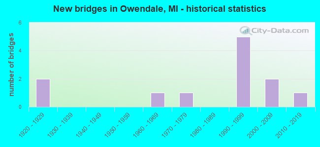
- New bridges - historical statistics
- 21920-1929
- 11960-1969
- 11970-1979
- 51990-1999
- 22000-2009
- 12010-2019

- Bridge Condition - Deck
- 10.0%Very good
- 50.0%Good
- 20.0%Satisfactory
- 20.0%Fair

- Bridge Condition - Superstructure
- 40.0%Good
- 30.0%Satisfactory
- 20.0%Fair
- 10.0%Poor

- Bridge Condition - Substructure
- 70.0%Good
- 10.0%Satisfactory
- 20.0%Fair

- Bridge Condition - Channel
- 36.4%Very good
- 27.3%Good
- 18.2%Satisfactory
- 18.2%Poor
Find on map >> Show street view
Structure Number: 3555, Location: SEC 25-36 WINSOR TWP (Lat: 43.772853, Lng: -83.248350), Route carried "on" structure: County highway 3230, Year Built: 1993, Status: Open, Structure Length: 2.80m (9.19ft), Average Daily Traffic: 195 (year 2009), Truck Traffic: 1%, Average Future Daily Traffic: 355 (year 2029), Design Load: HS 20, Features Intersected: PIGEON RIVER, Facility Carried by Structure: STEIN ROAD
Minimum Vertical Clearance: 30.48m (100.00ft), Kilometerpoint: 10.680, Lanes on structure: 2, Owner: County Highway Agency, Approaching Roadway Width: 9.1m (29.9ft), Material/Design: Prestressed concrete, Design/Construction: Box Beam or Girders - Multiple, Number Of Spans In Main Unit: 2, Length of Maximum Span: 14.0m (45.9ft), Curb-To-Curb Width: 9.6m (31.5ft), Out-to-Out Width: 10.5m (34.4ft)
Condition: Deck: Good, Superstructure: Fair, Substructure: Good, Channel: Poor, Operating Rating: 50.2 metric tons, Method Used To Determine Operating Rating: Load and Resistance Factor Rating (LRFR) rating reported by rating factor(RF) method using HL-93 loadings, Inventory Rating: 38.6 metric tons, Method Used To Determine Inventory Rating: Load and Resistance Factor Rating (LRFR) rating reported by rating factor(RF) method using HL-93 loadings, Structural Evaluation: Somewhat better than minimum adequacy, Deck Geometry: Equal to present minimum criteria, Waterway Adequacy: Better than present minimum criteria, Approach Roadway Alignment: Equal to present minimum criteria, Designated Inspection Frequency: Every 24 months, Inspection Date: September 2021, Deck Structure Type: Concrete Precast Panels, Wearing Surface/Protective System: Wearing Surface: Bituminous, Membrane: Built-up
Find on map >> Show street view
Structure Number: 3569, Location: SEC 28-33 BROOKFIELD TWP (Lat: 43.684789, Lng: -83.315631), Route carried "on" structure: ServiceCounty highway , Year Built: 2008, Status: Open, Structure Length: 1.52m (4.99ft), Average Daily Traffic: 160 (year 2009), Truck Traffic: 3%, Average Future Daily Traffic: 290 (year 2029), Design Load: HS 20, Features Intersected: BROOKFIELD I/C DRAIN, Facility Carried by Structure: BACH ROAD
Minimum Vertical Clearance: 30.48m (100.00ft), Kilometerpoint: 12.185, Lanes on structure: 2, Owner: County Highway Agency, Approaching Roadway Width: 9.1m (29.9ft), Material/Design: Prestressed concrete, Design/Construction: Box Beam or Girders - Multiple, Number Of Spans In Main Unit: 1, Length of Maximum Span: 14.8m (48.6ft), Curb-To-Curb Width: 8.7m (28.5ft), Out-to-Out Width: 9.5m (31.2ft)
Condition: Deck: Very good, Superstructure: Good, Substructure: Good, Channel: Very good, Operating Rating: 96.6 metric tons, Method Used To Determine Operating Rating: Load Factor (LF) rating reported by rating factor (RF) method using MS18 loading, Inventory Rating: 57.7 metric tons, Method Used To Determine Inventory Rating: Load Factor (LF) rating reported by rating factor (RF) method using MS18 loading, Structural Evaluation: Better than present minimum criteria, Deck Geometry: Equal to present minimum criteria, Waterway Adequacy: Equal to present desirable criteria, Approach Roadway Alignment: Equal to present minimum criteria, Designated Inspection Frequency: Every 24 months, Inspection Date: October 2021, Deck Structure Type: Concrete Cast-file-Place, Wearing Surface/Protective System: Wearing Surface: Bituminous, Membrane: Built-up
Find on map >> Show street view
Structure Number: 3571, Location: SEC15-22 BROOKFIELD TWP (Lat: 43.714061, Lng: -83.296664), Route carried "on" structure: ServiceCounty highway , Year Built: 1993, Status: Open, Structure Length: 1.81m (5.94ft), Average Daily Traffic: 130 (year 2009), Truck Traffic: 1%, Average Future Daily Traffic: 235 (year 2029), Design Load: H 20, Features Intersected: SHEBEON DRAIN, Facility Carried by Structure: RESCUE ROAD
Minimum Vertical Clearance: 30.48m (100.00ft), Kilometerpoint: 11.181, Lanes on structure: 2, Owner: County Highway Agency, Approaching Roadway Width: 8.5m (27.9ft), Skew: 4 degrees, Material/Design: Aluminum, Iron, Design/Construction: Culvert, Number Of Spans In Main Unit: 1, Length of Maximum Span: 10.4m (34.1ft), Curb-To-Curb Width: 12.8m (42.0ft), Out-to-Out Width: 12.8m (42.0ft)
Condition: Channel: Good, Culverts: Good, Operating Rating: 46.7 metric tons, Method Used To Determine Operating Rating: Load Factor (LF) rating reported by rating factor (RF) method using MS18 loading, Inventory Rating: 28.2 metric tons, Method Used To Determine Inventory Rating: Load Factor (LF) rating reported by rating factor (RF) method using MS18 loading, Structural Evaluation: Better than present minimum criteria, Deck Geometry: Superior to present desirable criteria, Waterway Adequacy: Equal to present desirable criteria, Approach Roadway Alignment: Better than present minimum criteria, Designated Inspection Frequency: Every 24 months, Inspection Date: September 2021, Wearing Surface/Protective System: Wearing Surface: Bituminous
Find on map >> Show street view
Structure Number: 3572, Location: SEC. 5-8 BROOKFIELD TWP. (Lat: 43.742303, Lng: -83.336658), Route carried "on" structure: ServiceCounty highway , Year Built: 1996, Status: Open, Structure Length: 2.13m (6.99ft), Average Daily Traffic: 200 (year 2009), Truck Traffic: 1%, Average Future Daily Traffic: 360 (year 2029), Design Load: HS 20+Mod, Features Intersected: SHEBEON DRAIN, Facility Carried by Structure: CANBORO ROAD
Minimum Vertical Clearance: 30.48m (100.00ft), Kilometerpoint: 8.107, Lanes on structure: 2, Owner: County Highway Agency, Approaching Roadway Width: 9.1m (29.9ft), Skew: 1 degrees, Material/Design: Prestressed concrete, Design/Construction: Box Beam or Girders - Multiple, Number Of Spans In Main Unit: 1, Length of Maximum Span: 20.9m (68.6ft), Curb-To-Curb Width: 9.6m (31.5ft), Out-to-Out Width: 10.5m (34.4ft)
Condition: Deck: Fair, Superstructure: Good, Substructure: Good, Channel: Very good, Operating Rating: 72.4 metric tons, Method Used To Determine Operating Rating: Load Factor (LF), Inventory Rating: 43.4 metric tons, Method Used To Determine Inventory Rating: Load Factor (LF), Structural Evaluation: Better than present minimum criteria, Deck Geometry: Equal to present minimum criteria, Waterway Adequacy: Equal to present desirable criteria, Approach Roadway Alignment: Better than present minimum criteria, Designated Inspection Frequency: Every 24 months, Inspection Date: September 2021, Deck Structure Type: Concrete Precast Panels, Wearing Surface/Protective System: Wearing Surface: Bituminous, Membrane: Built-up
Find on map >> Show street view
Structure Number: 3575, Location: SEC 5-6 BROOKFIELD TWP (Lat: 43.746208, Lng: -83.337039), Route carried "on" structure: ServiceCounty highway , Year Built: 1996, Status: Open, Structure Length: 2.13m (6.99ft), Average Daily Traffic: 50 (year 2009), Truck Traffic: 1%, Average Future Daily Traffic: 90 (year 2029), Design Load: HS 20+Mod, Features Intersected: SHEBEON DRAIN, Facility Carried by Structure: RISKEY ROAD
Minimum Vertical Clearance: 30.48m (100.00ft), Kilometerpoint: 8.462, Lanes on structure: 2, Owner: County Highway Agency, Approaching Roadway Width: 9.1m (29.9ft), Material/Design: Prestressed concrete, Design/Construction: Box Beam or Girders - Multiple, Number Of Spans In Main Unit: 1, Length of Maximum Span: 20.9m (68.6ft), Curb-To-Curb Width: 9.6m (31.5ft), Out-to-Out Width: 10.5m (34.4ft)
Condition: Deck: Good, Superstructure: Good, Substructure: Good, Channel: Good, Operating Rating: 72.4 metric tons, Method Used To Determine Operating Rating: Load Factor (LF), Inventory Rating: 43.4 metric tons, Method Used To Determine Inventory Rating: Load Factor (LF), Structural Evaluation: Better than present minimum criteria, Deck Geometry: Better than present minimum criteria, Waterway Adequacy: Equal to present desirable criteria, Approach Roadway Alignment: Better than present minimum criteria, Designated Inspection Frequency: Every 24 months, Inspection Date: October 2021, Deck Structure Type: Concrete Precast Panels, Wearing Surface/Protective System: Wearing Surface: Bituminous, Membrane: Built-up
Find on map >> Show street view
Structure Number: 3576, Location: SEC. 28-29 BROOKFIELD TWP (Lat: 43.699111, Lng: -83.316233), Route carried "on" structure: ServiceCounty highway , Year Built: 1927, Status: Posted for load, Structure Length: 0.85m (2.79ft), Average Daily Traffic: 20 (year 2009), Average Future Daily Traffic: 80 (year 2029), Design Load: H 15, Features Intersected: COLUMBIA DRAIN, Facility Carried by Structure: POBANZ ROAD
Minimum Vertical Clearance: 30.48m (100.00ft), Kilometerpoint: 3.199, Lanes on structure: 2, Owner: County Highway Agency, Approaching Roadway Width: 9.1m (29.9ft), Material/Design: Steel, Design/Construction: Stringer/Multi-beam, Number Of Spans In Main Unit: 1, Length of Maximum Span: 8.0m (26.2ft), Curb-To-Curb Width: 6.2m (20.3ft), Out-to-Out Width: 6.2m (20.3ft)
Condition: Deck: Satisfactory, Superstructure: Satisfactory, Substructure: Fair, Channel: Very good, Operating Rating: 33.4 metric tons, Method Used To Determine Operating Rating: Load Factor (LF) rating reported by rating factor (RF) method using MS18 loading, Inventory Rating: 20.1 metric tons, Method Used To Determine Inventory Rating: Load Factor (LF) rating reported by rating factor (RF) method using MS18 loading, Structural Evaluation: Somewhat better than minimum adequacy, Deck Geometry: Somewhat better than minimum adequacy, Waterway Adequacy: Equal to present desirable criteria, Approach Roadway Alignment: Equal to present minimum criteria, Bridge Posting: Required (Relationship of Operating Rating to Maximum Legal Load: 30.0 - 39.9% below), Designated Inspection Frequency: Every 24 months, Inspection Date: October 2021, Deck Structure Type: Concrete Cast-file-Place, Wearing Surface/Protective System: Wearing Surface: Monolithic Concrete
Find on map >> Show street view
Structure Number: 3593, Location: SEC. 5-8 GRANT TWP. (Lat: 43.744758, Lng: -83.211492), Route carried "on" structure: ServiceCounty highway , Year Built: 1970, Status: Open, Structure Length: 0.80m (2.62ft), Average Daily Traffic: 75 (year 2009), Truck Traffic: 1%, Average Future Daily Traffic: 135 (year 2029), Design Load: H 20, Features Intersected: WEST BR. PIGEON RIVER, Facility Carried by Structure: CANBORO ROAD
Minimum Vertical Clearance: 30.48m (100.00ft), Kilometerpoint: 18.191, Lanes on structure: 2, Owner: County Highway Agency, Approaching Roadway Width: 7.9m (25.9ft), Material/Design: Steel, Design/Construction: Culvert, Number Of Spans In Main Unit: 2, Length of Maximum Span: 3.5m (11.5ft)
Condition: Channel: Poor, Culverts: Good, Operating Rating: 97.2 metric tons, Method Used To Determine Operating Rating: Load Factor (LF) rating reported by rating factor (RF) method using MS18 loading, Inventory Rating: 97.2 metric tons, Method Used To Determine Inventory Rating: Load Factor (LF) rating reported by rating factor (RF) method using MS18 loading, Structural Evaluation: Better than present minimum criteria, Waterway Adequacy: Equal to present minimum criteria, Approach Roadway Alignment: Better than present minimum criteria, Designated Inspection Frequency: Every 24 months, Inspection Date: September 2021
Find on map >> Show street view
Structure Number: 3595, Location: SEC. 6 GRANT TWP. (Lat: 43.753911, Lng: -83.238014), Route carried "on" structure: ServiceCounty highway , Year Built: 2004, Status: Open, Structure Length: 2.07m (6.79ft), Average Daily Traffic: 100 (year 2009), Average Future Daily Traffic: 180 (year 2029), Design Load: HS 20, Features Intersected: PIGEON RIVER, Facility Carried by Structure: GAGETOWN ROAD
Minimum Vertical Clearance: 30.48m (100.00ft), Kilometerpoint: 9.120, Lanes on structure: 2, Owner: County Highway Agency, Approaching Roadway Width: 9.1m (29.9ft), Material/Design: Prestressed concrete, Design/Construction: Box Beam or Girders - Multiple, Number Of Spans In Main Unit: 1, Length of Maximum Span: 19.5m (64.0ft), Curb-To-Curb Width: 8.7m (28.5ft), Out-to-Out Width: 9.5m (31.2ft)
Condition: Deck: Satisfactory, Superstructure: Poor, Substructure: Good, Channel: Very good, Operating Rating: 45.4 metric tons, Method Used To Determine Operating Rating: Load and Resistance Factor Rating (LRFR) rating reported by rating factor(RF) method using HL-93 loadings, Inventory Rating: 35.0 metric tons, Method Used To Determine Inventory Rating: Load and Resistance Factor Rating (LRFR) rating reported by rating factor(RF) method using HL-93 loadings, Structural Evaluation: Meets minimum limits, Deck Geometry: Better than present minimum criteria, Waterway Adequacy: Equal to present minimum criteria, Approach Roadway Alignment: Equal to present desirable criteria, Designated Inspection Frequency: Every 12 months, Inspection Date: September 2021, Deck Structure Type: Concrete Precast Panels, Wearing Surface/Protective System: Wearing Surface: Bituminous, Membrane: Built-up
Find on map >> Show street view
Structure Number: 3596, Location: SEC. 5-6 GRANT TWP. (Lat: 43.745700, Lng: -83.219433), Route carried "on" structure: ServiceCounty highway , Year Built: 2010, Status: Open, Structure Length: 1.80m (5.91ft), Average Daily Traffic: 60 (year 2010), Truck Traffic: 5%, Average Future Daily Traffic: 105 (year 2030), Design Load: HS 20+Mod, Features Intersected: PIGEON RIVER, Facility Carried by Structure: MAXWELL ROAD
Minimum Vertical Clearance: 30.48m (100.00ft), Kilometerpoint: 8.153, Lanes on structure: 2, Owner: County Highway Agency, Approaching Roadway Width: 8.5m (27.9ft), Material/Design: Prestressed concrete, Design/Construction: Box Beam or Girders - Multiple, Number Of Spans In Main Unit: 1, Length of Maximum Span: 17.6m (57.7ft), Curb-To-Curb Width: 8.7m (28.5ft), Out-to-Out Width: 9.5m (31.2ft)
Condition: Deck: Good, Superstructure: Good, Substructure: Good, Channel: Satisfactory, Operating Rating: 89.3 metric tons, Method Used To Determine Operating Rating: Load and Resistance Factor (LRFR), Inventory Rating: 53.5 metric tons, Method Used To Determine Inventory Rating: Load and Resistance Factor (LRFR), Structural Evaluation: Better than present minimum criteria, Deck Geometry: Better than present minimum criteria, Waterway Adequacy: Equal to present desirable criteria, Approach Roadway Alignment: Equal to present desirable criteria, Designated Inspection Frequency: Every 24 months, Inspection Date: September 2021, Deck Structure Type: Concrete Precast Panels, Wearing Surface/Protective System: Wearing Surface: Bituminous, Membrane: Preformed Fabric
Find on map >> Show street view
Structure Number: 3597, Location: SEC. 8-9 GRANT TWP. (Lat: 43.743731, Lng: -83.199439), Route carried "on" structure: ServiceCounty highway , Year Built: 1920, Status: Posted for load, Structure Length: 0.82m (2.69ft), Average Daily Traffic: 20 (year 2009), Average Future Daily Traffic: 36 (year 2029), Design Load: H 10, Features Intersected: WEST BR. PIGEON RIVER, Facility Carried by Structure: FARVER ROAD
Minimum Vertical Clearance: 30.48m (100.00ft), Kilometerpoint: 5.121, Lanes on structure: 2, Owner: County Highway Agency, Approaching Roadway Width: 3.7m (12.1ft), Material/Design: Steel, Design/Construction: Stringer/Multi-beam, Number Of Spans In Main Unit: 1, Length of Maximum Span: 7.9m (25.9ft), Curb-To-Curb Width: 4.5m (14.8ft), Out-to-Out Width: 4.9m (16.1ft)
Condition: Deck: Fair, Superstructure: Fair, Substructure: Fair, Channel: Satisfactory, Operating Rating: 25.3 metric tons, Method Used To Determine Operating Rating: Load Factor (LF) rating reported by rating factor (RF) method using MS18 loading, Inventory Rating: 15.2 metric tons, Method Used To Determine Inventory Rating: Load Factor (LF) rating reported by rating factor (RF) method using MS18 loading, Structural Evaluation: Meets minimum limits, Waterway Adequacy: Better than present minimum criteria, Approach Roadway Alignment: Meets minimum limits, Bridge Posting: Required (Relationship of Operating Rating to Maximum Legal Load: > 39.9% below), Length Of Structure Improvement: 1.49m (4.89ft), Designated Inspection Frequency: Every 24 months, Inspection Date: September 2021, Bridge Improvement Cost: $280,000, Roadway Improvement Cost: $121,000, Total Project Cost: $441,000, Deck Structure Type: Concrete Cast-file-Place, Wearing Surface/Protective System: Wearing Surface: Monolithic Concrete
Find on map >> Show street view
Structure Number: 3674, Location: SEC 36 WINSOR TWP (Lat: 43.758467, Lng: -83.244531), Route carried "on" structure: ServiceCounty highway , Year Built: 1993, Status: Open, Structure Length: 2.01m (6.59ft), Average Daily Traffic: 200 (year 2009), Truck Traffic: 1%, Average Future Daily Traffic: 360 (year 2029), Design Load: HS 20, Features Intersected: PIGEON RIVER, Facility Carried by Structure: KILMANAGH ROAD
Minimum Vertical Clearance: 30.48m (100.00ft), Kilometerpoint: 16.516, Lanes on structure: 2, Owner: County Highway Agency, Approaching Roadway Width: 9.1m (29.9ft), Material/Design: Prestressed concrete, Design/Construction: Tee Beam, Number Of Spans In Main Unit: 2, Length of Maximum Span: 9.6m (31.5ft), Curb-To-Curb Width: 9.1m (29.9ft), Out-to-Out Width: 9.8m (32.2ft)
Condition: Deck: Good, Superstructure: Satisfactory, Substructure: Good, Channel: Good, Operating Rating: 36.9 metric tons, Method Used To Determine Operating Rating: Load and Resistance Factor Rating (LRFR) rating reported by rating factor(RF) method using HL-93 loadings, Inventory Rating: 28.5 metric tons, Method Used To Determine Inventory Rating: Load and Resistance Factor Rating (LRFR) rating reported by rating factor(RF) method using HL-93 loadings, Structural Evaluation: Equal to present minimum criteria, Deck Geometry: Equal to present minimum criteria, Waterway Adequacy: Equal to present desirable criteria, Approach Roadway Alignment: Equal to present desirable criteria, Designated Inspection Frequency: Every 24 months, Inspection Date: September 2021, Deck Structure Type: Concrete Precast Panels, Wearing Surface/Protective System: Wearing Surface: Bituminous, Membrane: Preformed Fabric
Find on map >> Show street view
Structure Number: 10001, Location: 5.9 MI NE OF MACOMB COL (Lat: 42.797686, Lng: -82.650361), Route carried "on" structure: County highway , Year Built: 1964, Year Reconstructed: 2003, Status: Open, Structure Length: 9.63m (31.59ft), Average Daily Traffic: 2,130 (year 1993), Truck Traffic: 4%, Average Future Daily Traffic: 3,700 (year 2020), Design Load: HS 20, Features Intersected: I-94, Facility Carried by Structure: ST CLAIR HWY
Minimum Vertical Clearance: 30.48m (100.00ft), Kilometerpoint: 6.803, Lanes on structure: 2, Lanes under structure: 4, Owner: State Highway Agency, Approaching Roadway Width: 12.8m (42.0ft), Skew: 4 degrees, Material/Design: Prestressed concrete, Design/Construction: Stringer/Multi-beam, Number Of Spans In Main Unit: 4, Length of Maximum Span: 32.4m (106.3ft), Curb-To-Curb Width: 9.8m (32.2ft), Out-to-Out Width: 10.7m (35.1ft)
Condition: Deck: Good, Superstructure: Satisfactory, Substructure: Satisfactory, Operating Rating: 59.3 metric tons, Method Used To Determine Operating Rating: Load Factor (LF), Inventory Rating: 35.5 metric tons, Method Used To Determine Inventory Rating: Load Factor (LF), Structural Evaluation: Equal to present minimum criteria, Deck Geometry: Meets minimum limits, Underclear: Equal to present minimum criteria, Approach Roadway Alignment: Equal to present desirable criteria, Designated Inspection Frequency: Every 24 months, Inspection Date: August 2020, Deck Structure Type: Concrete Cast-file-Place, Wearing Surface/Protective System: Wearing Surface: Epoxy Overlay, Deck Protection: Epoxy Coated Reinforcing