Bridge Statistics for Ovid, Michigan (MI)
Condition, Traffic, Stress, Structural Evaluation, Project Costs
- National Bridge Inventory (NBI) Statistics
- 22Number of bridges
- 105ft / 31.9mTotal length
- $720,000Total costs
- 49,211Total average daily traffic
- 2,653Total average daily truck traffic
- 74,195Total future (year 2007) average daily traffic
- National Bridge Inventory (NBI) Registered Bridges for Ovid
- No street view available for this location
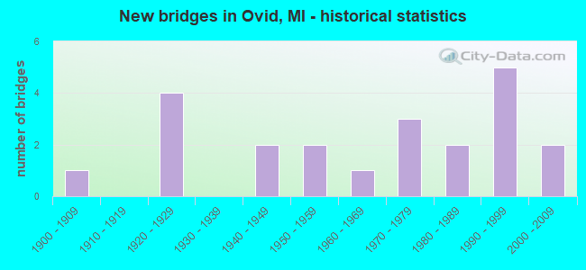
- New bridges - historical statistics
- 11900-1909
- 41920-1929
- 21940-1949
- 21950-1959
- 11960-1969
- 31970-1979
- 21980-1989
- 51990-1999
- 22000-2009

- Reconstructed bridges - Historical Statistics
- 11950-1959
- 01960-1969
- 11970-1979
- 21980-1989
- 11990-1999


- Bridge Condition - Deck
- 44.4%Good
- 33.3%Satisfactory
- 16.7%Fair
- 5.6%Poor

- Bridge Condition - Superstructure
- 11.1%Very good
- 38.9%Good
- 16.7%Satisfactory
- 11.1%Fair
- 16.7%Poor
- 5.6%Serious

- Bridge Condition - Substructure
- 5.6%Very good
- 27.8%Good
- 38.9%Satisfactory
- 16.7%Fair
- 5.6%Poor
- 5.6%Critical

- Bridge Condition - Channel
- 22.7%Good
- 45.5%Satisfactory
- 22.7%Fair
- 9.1%Poor

- Bridge Condition - Culverts
- 50.0%Good
- 50.0%Satisfactory
Find on map >> Show street view
Structure Number: 203, Location: APPROX 0.1 MI S OF 128TH (Lat: 42.622472, Lng: -85.741400), Route carried "on" structure: County highway 369, Year Built: 1968, Status: Open, Structure Length: 0.69m (2.26ft), Average Daily Traffic: 1,327 (year 2003), Truck Traffic: 7%, Average Future Daily Traffic: 2,654 (year 2023), Design Load: HS 20+Mod, Features Intersected: MILLER CREEK, Facility Carried by Structure: 20TH STREET
Minimum Vertical Clearance: 30.48m (100.00ft), Kilometerpoint: 9.481, Lanes on structure: 2, Owner: County Highway Agency, Approaching Roadway Width: 12.2m (40.0ft), Material/Design: Steel, Design/Construction: Culvert, Number Of Spans In Main Unit: 2, Length of Maximum Span: 2.9m (9.5ft)
Condition: Channel: Satisfactory, Culverts: Satisfactory, Operating Rating: 43.1 metric tons, Method Used To Determine Operating Rating: Load Factor (LF) rating reported by rating factor (RF) method using MS18 loading, Inventory Rating: 25.9 metric tons, Method Used To Determine Inventory Rating: Load Factor (LF) rating reported by rating factor (RF) method using MS18 loading, Structural Evaluation: Equal to present minimum criteria, Waterway Adequacy: Somewhat better than minimum adequacy, Approach Roadway Alignment: Equal to present desirable criteria, Designated Inspection Frequency: Every 24 months, Inspection Date: October 2021
Find on map >> Show street view
Structure Number: 1889, Location: 2.0 MI W OF OVID (Lat: 43.001142, Lng: -84.411042), Route carried "on" structure: State highway 21, Year Built: 1929, Year Reconstructed: 2004, Status: Open, Structure Length: 1.22m (4.00ft), Average Daily Traffic: 7,103 (year 2007), Truck Traffic: 6%, Average Future Daily Traffic: 8,615 (year 2018), Design Load: HS 25 or greater, Features Intersected: MAPLE RIVER
Minimum Vertical Clearance: 30+ m (98+ ft), Kilometerpoint: 34.761, Lanes on structure: 2, Base Highway Network: Yes (Inventory Route: 20, Subroute: 9), Owner: State Highway Agency, Approaching Roadway Width: 12.2m (40.0ft), Material/Design: Prestressed concrete, Design/Construction: Stringer/Multi-beam, Number Of Spans In Main Unit: 1, Length of Maximum Span: 12.2m (40.0ft), Curb-To-Curb Width: 13.4m (44.0ft), Out-to-Out Width: 14.4m (47.2ft)
Condition: Deck: Good, Superstructure: Good, Substructure: Satisfactory, Channel: Satisfactory, Operating Rating: 65.1 metric tons, Method Used To Determine Operating Rating: Load Factor (LF) rating reported by rating factor (RF) method using MS18 loading, Inventory Rating: 32.7 metric tons, Method Used To Determine Inventory Rating: Load Factor (LF) rating reported by rating factor (RF) method using MS18 loading, Structural Evaluation: Equal to present minimum criteria, Deck Geometry: Equal to present minimum criteria, Waterway Adequacy: Equal to present desirable criteria, Approach Roadway Alignment: Equal to present desirable criteria, Designated Inspection Frequency: Every 24 months, Inspection Date: October 2020, Deck Structure Type: Concrete Cast-file-Place, Wearing Surface/Protective System: Deck Protection: Epoxy Coated Reinforcing
Find on map >> Show street view
Structure Number: 189, Location: 1.2 MI W OF OVID (Lat: 43.001297, Lng: -84.395717), Route carried "on" structure: State highway 21, Year Built: 1949, Status: Open, Structure Length: 1.22m (4.00ft), Average Daily Traffic: 7,103 (year 2007), Truck Traffic: 6%, Average Future Daily Traffic: 8,615 (year 2018), Design Load: HS 20, Features Intersected: ALDER CREEK
Minimum Vertical Clearance: 30.48m (100.00ft), Kilometerpoint: 36.010, Lanes on structure: 2, Base Highway Network: Yes (Inventory Route: 20, Subroute: 9), Owner: State Highway Agency, Approaching Roadway Width: 13.4m (44.0ft), Material/Design: Steel, Design/Construction: Stringer/Multi-beam, Number Of Spans In Main Unit: 1, Length of Maximum Span: 12.2m (40.0ft), Curb or Sidewalk Widths: Left: 0.4m (1.3ft), Right: 0.4m (1.3ft), Curb-To-Curb Width: 11.6m (38.1ft), Out-to-Out Width: 13.2m (43.3ft)
Condition: Deck: Satisfactory, Superstructure: Fair, Substructure: Satisfactory, Channel: Satisfactory, Operating Rating: 88.5 metric tons, Method Used To Determine Operating Rating: Load Factor (LF) rating reported by rating factor (RF) method using MS18 loading, Inventory Rating: 52.8 metric tons, Method Used To Determine Inventory Rating: Load Factor (LF) rating reported by rating factor (RF) method using MS18 loading, Structural Evaluation: Somewhat better than minimum adequacy, Deck Geometry: Somewhat better than minimum adequacy, Waterway Adequacy: Equal to present desirable criteria, Approach Roadway Alignment: Equal to present desirable criteria, Length Of Structure Improvement: 1.22m (4.00ft), Designated Inspection Frequency: Every 24 months, Inspection Date: October 2020, Bridge Improvement Cost: $17,000, Roadway Improvement Cost: $3,000, Total Project Cost: $34,000, Deck Structure Type: Concrete Cast-file-Place, Wearing Surface/Protective System: Wearing Surface: Bituminous
Find on map >> Show street view
Structure Number: 1891, Location: IN OVID (Lat: 43.000853, Lng: -84.370222), Route carried "on" structure: State highway 21, Year Built: 1997, Status: Open, Structure Length: 2.80m (9.19ft), Average Daily Traffic: 6,505 (year 2007), Truck Traffic: 6%, Average Future Daily Traffic: 8,895 (year 2018), Design Load: HS 25 or greater, Features Intersected: MAPLE RIVER
Minimum Vertical Clearance: 30.48m (100.00ft), Kilometerpoint: 38.090, Lanes on structure: 2, Base Highway Network: Yes (Inventory Route: 20, Subroute: 9), Owner: State Highway Agency, Approaching Roadway Width: 13.4m (44.0ft), Skew: 3 degrees, Material/Design: Prestressed concrete, Design/Construction: Box Beam or Girders - Multiple, Number Of Spans In Main Unit: 1, Length of Maximum Span: 28.0m (91.9ft), Curb-To-Curb Width: 13.4m (44.0ft), Out-to-Out Width: 14.3m (46.9ft)
Condition: Deck: Satisfactory, Superstructure: Satisfactory, Substructure: Good, Channel: Satisfactory, Operating Rating: 97.2 metric tons, Method Used To Determine Operating Rating: Load Factor (LF) rating reported by rating factor (RF) method using MS18 loading, Inventory Rating: 60.6 metric tons, Method Used To Determine Inventory Rating: Load Factor (LF) rating reported by rating factor (RF) method using MS18 loading, Structural Evaluation: Equal to present minimum criteria, Deck Geometry: Equal to present minimum criteria, Waterway Adequacy: Equal to present desirable criteria, Approach Roadway Alignment: Equal to present desirable criteria, Designated Inspection Frequency: Every 24 months, Inspection Date: October 2020, Deck Structure Type: Concrete Cast-file-Place, Wearing Surface/Protective System: Wearing Surface: Monolithic Concrete, Deck Protection: Epoxy Coated Reinforcing
Find on map >> Show street view
Structure Number: 1935, Location: 1/4 MI S OF WALKER RD (Lat: 43.010439, Lng: -84.425753), Route carried "on" structure: County highway , Year Built: 1928, Year Reconstructed: 1958, Status: Open, Structure Length: 0.97m (3.18ft), Average Daily Traffic: 1,083 (year 2011), Truck Traffic: 2%, Average Future Daily Traffic: 1,956 (year 2031), Design Load: HS 20, Features Intersected: MAPLE RIVER BRANCH, Facility Carried by Structure: SHEPARDSVILLE RD
Minimum Vertical Clearance: 30.48m (100.00ft), Kilometerpoint: 14.366, Lanes on structure: 2, Owner: County Highway Agency, Approaching Roadway Width: 9.8m (32.2ft), Material/Design: Prestressed concrete, Design/Construction: Box Beam or Girders - Multiple, Number Of Spans In Main Unit: 1, Length of Maximum Span: 9.1m (29.9ft), Curb-To-Curb Width: 6.1m (20.0ft), Out-to-Out Width: 6.4m (21.0ft)
Condition: Deck: Satisfactory, Superstructure: Poor, Substructure: Fair, Channel: Satisfactory, Operating Rating: 56.2 metric tons, Method Used To Determine Operating Rating: Load Factor (LF), Inventory Rating: 33.7 metric tons, Method Used To Determine Inventory Rating: Load Factor (LF), Structural Evaluation: Meets minimum limits, Deck Geometry: High priority of replacement, Waterway Adequacy: Equal to present minimum criteria, Approach Roadway Alignment: Equal to present minimum criteria, Length Of Structure Improvement: 3.05m (10.01ft), Designated Inspection Frequency: Every 12 months, Inspection Date: October 2021, Bridge Improvement Cost: $198,000, Roadway Improvement Cost: $20,000, Total Project Cost: $228,000, Deck Structure Type: Other, Wearing Surface/Protective System: Wearing Surface: Bituminous
Find on map >> Show street view
Structure Number: 1936, Location: 1/4 MI N OF WALKER RD (Lat: 43.014408, Lng: -84.425808), Route carried "on" structure: County highway , Year Built: 1958, Status: Open, Structure Length: 2.43m (7.97ft), Average Daily Traffic: 1,083 (year 2011), Truck Traffic: 2%, Average Future Daily Traffic: 1,956 (year 2031), Design Load: HS 20, Features Intersected: MAPLE RIVER, Facility Carried by Structure: SHEPARDSVILLE RD
Minimum Vertical Clearance: 30.48m (100.00ft), Kilometerpoint: 14.805, Lanes on structure: 2, Owner: County Highway Agency, Approaching Roadway Width: 9.8m (32.2ft), Skew: 1 degrees, Material/Design: Prestressed concrete, Design/Construction: Box Beam or Girders - Multiple, Number Of Spans In Main Unit: 2, Length of Maximum Span: 12.2m (40.0ft), Curb-To-Curb Width: 7.6m (24.9ft), Out-to-Out Width: 9.3m (30.5ft)
Condition: Deck: Satisfactory, Superstructure: Poor, Substructure: Satisfactory, Channel: Fair, Operating Rating: 72.4 metric tons, Method Used To Determine Operating Rating: Load Factor (LF), Inventory Rating: 43.5 metric tons, Method Used To Determine Inventory Rating: Load Factor (LF), Structural Evaluation: Meets minimum limits, Deck Geometry: Meets minimum limits, Waterway Adequacy: Equal to present minimum criteria, Approach Roadway Alignment: Equal to present desirable criteria, Length Of Structure Improvement: 2.44m (8.01ft), Designated Inspection Frequency: Every 12 months, Inspection Date: October 2021, Bridge Improvement Cost: $168,000, Total Project Cost: $178,000, Deck Structure Type: Other, Wearing Surface/Protective System: Wearing Surface: Bituminous
Find on map >> Show street view
Structure Number: 194, Location: 1/2 MI N OF M-21 (Lat: 43.006375, Lng: -84.386425), Route carried "on" structure: County highway 1995, Year Built: 1948, Status: Open, Structure Length: 1.82m (5.97ft), Average Daily Traffic: 2,720 (year 2010), Truck Traffic: 5%, Average Future Daily Traffic: 6,397 (year 2031), Design Load: H 20, Features Intersected: MAPLE RIVER, Facility Carried by Structure: HOLLISTER ROAD
Minimum Vertical Clearance: 30.48m (100.00ft), Kilometerpoint: 16.596, Lanes on structure: 2, Owner: County Highway Agency, Approaching Roadway Width: 10.4m (34.1ft), Material/Design: Steel, Design/Construction: Stringer/Multi-beam, Number Of Spans In Main Unit: 1, Length of Maximum Span: 17.9m (58.7ft), Curb-To-Curb Width: 7.9m (25.9ft), Out-to-Out Width: 9.6m (31.5ft)
Condition: Deck: Fair, Superstructure: Poor, Substructure: Satisfactory, Channel: Satisfactory, Operating Rating: 43.8 metric tons, Method Used To Determine Operating Rating: Load Factor (LF), Inventory Rating: 26.3 metric tons, Method Used To Determine Inventory Rating: Load Factor (LF), Structural Evaluation: Meets minimum limits, Deck Geometry: High priority of corrective action, Waterway Adequacy: Equal to present minimum criteria, Approach Roadway Alignment: Better than present minimum criteria, Designated Inspection Frequency: Every 24 months, Inspection Date: October 2020, Deck Structure Type: Concrete Cast-file-Place, Wearing Surface/Protective System: Wearing Surface: Bituminous
Find on map >> Show street view
Structure Number: 1942, Location: 1/2 MI S OF WOODWORTH RD (Lat: 42.984203, Lng: -84.371175), Route carried "on" structure: County highway 1999, Year Built: 1979, Status: Open, Structure Length: 0.85m (2.79ft), Average Daily Traffic: 1,532 (year 2011), Truck Traffic: 2%, Average Future Daily Traffic: 2,767 (year 2031), Design Load: HS 20, Features Intersected: ALDER CREEK, Facility Carried by Structure: OVID ROAD
Minimum Vertical Clearance: 30.48m (100.00ft), Kilometerpoint: 4.579, Lanes on structure: 2, Owner: County Highway Agency, Approaching Roadway Width: 10.4m (34.1ft), Material/Design: Prestressed concrete, Design/Construction: Box Beam or Girders - Multiple, Number Of Spans In Main Unit: 1, Length of Maximum Span: 8.5m (27.9ft), Curb-To-Curb Width: 11.0m (36.1ft), Out-to-Out Width: 11.1m (36.4ft)
Condition: Deck: Good, Superstructure: Good, Substructure: Satisfactory, Channel: Fair, Operating Rating: 60.8 metric tons, Method Used To Determine Operating Rating: Load Factor (LF), Inventory Rating: 36.5 metric tons, Method Used To Determine Inventory Rating: Load Factor (LF), Structural Evaluation: Equal to present minimum criteria, Deck Geometry: Equal to present minimum criteria, Waterway Adequacy: Equal to present desirable criteria, Approach Roadway Alignment: Equal to present desirable criteria, Designated Inspection Frequency: Every 24 months, Inspection Date: October 2020, Deck Structure Type: Other, Wearing Surface/Protective System: Wearing Surface: Bituminous, Membrane: Other
Find on map >> Show street view
Structure Number: 2001, Location: 0.2 MI W OF SHEPARDSVILLE (Lat: 42.972008, Lng: -84.430678), Route carried "on" structure: County highway , Year Built: 1920, Year Reconstructed: 1987, Status: Open, Structure Length: 0.73m (2.40ft), Average Daily Traffic: 107 (year 2004), Average Future Daily Traffic: 200 (year 2024), Design Load: HS 20, Features Intersected: MAPLE RIVER, Facility Carried by Structure: PARKS ROAD
Minimum Vertical Clearance: 30.48m (100.00ft), Kilometerpoint: 7.118, Lanes on structure: 2, Owner: County Highway Agency, Approaching Roadway Width: 7.9m (25.9ft), Material/Design: Prestressed concrete, Design/Construction: Box Beam or Girders - Multiple, Number Of Spans In Main Unit: 1, Length of Maximum Span: 7.0m (23.0ft), Curb-To-Curb Width: 5.2m (17.1ft), Out-to-Out Width: 5.5m (18.0ft)
Condition: Deck: Satisfactory, Superstructure: Satisfactory, Substructure: Fair, Channel: Poor, Operating Rating: 80.1 metric tons, Method Used To Determine Operating Rating: Load Factor (LF), Inventory Rating: 48.1 metric tons, Method Used To Determine Inventory Rating: Load Factor (LF), Structural Evaluation: Somewhat better than minimum adequacy, Deck Geometry: High priority of replacement, Waterway Adequacy: Equal to present minimum criteria, Approach Roadway Alignment: Better than present minimum criteria, Designated Inspection Frequency: Every 24 months, Inspection Date: October 2021, Deck Structure Type: Concrete Precast Panels, Wearing Surface/Protective System: Wearing Surface: Integral Concrete
Find on map >> Show street view
Structure Number: 2003, Location: 0.1 MI W OF HOLLISTER RD (Lat: 42.994153, Lng: -84.388661), Route carried "on" structure: County highway , Year Built: 1926, Year Reconstructed: 1986, Status: Open, Structure Length: 1.37m (4.49ft), Average Daily Traffic: 143 (year 2011), Average Future Daily Traffic: 258 (year 2031), Design Load: HS 20, Features Intersected: ALDER CREEK, Facility Carried by Structure: WILDCAT ROAD
Minimum Vertical Clearance: 30.48m (100.00ft), Kilometerpoint: 10.564, Lanes on structure: 2, Owner: County Highway Agency, Approaching Roadway Width: 7.3m (24.0ft), Skew: 4 degrees, Material/Design: Prestressed concrete, Design/Construction: Box Beam or Girders - Multiple, Number Of Spans In Main Unit: 1, Length of Maximum Span: 13.7m (44.9ft), Curb-To-Curb Width: 6.4m (21.0ft), Out-to-Out Width: 6.4m (21.0ft)
Condition: Deck: Good, Superstructure: Good, Substructure: Fair, Channel: Satisfactory, Operating Rating: 73.2 metric tons, Method Used To Determine Operating Rating: Load Factor (LF), Inventory Rating: 43.9 metric tons, Method Used To Determine Inventory Rating: Load Factor (LF), Structural Evaluation: Somewhat better than minimum adequacy, Deck Geometry: Meets minimum limits, Waterway Adequacy: Better than present minimum criteria, Approach Roadway Alignment: Equal to present minimum criteria, Designated Inspection Frequency: Every 24 months, Inspection Date: October 2021, Deck Structure Type: Concrete Cast-file-Place, Wearing Surface/Protective System: Wearing Surface: Integral Concrete
Find on map >> Show street view
Structure Number: 2004, Location: 0.2 MI W OF SHEPARDSVILLE (Lat: 43.015358, Lng: -84.433739), Route carried "on" structure: County highway , Year Built: 1986, Status: Open, Structure Length: 0.91m (2.99ft), Average Daily Traffic: 133 (year 2011), Average Future Daily Traffic: 240 (year 2031), Design Load: HS 20, Features Intersected: MAPLE RIVER, Facility Carried by Structure: WALKER ROAD
Minimum Vertical Clearance: 30.48m (100.00ft), Kilometerpoint: 4.104, Lanes on structure: 2, Owner: County Highway Agency, Approaching Roadway Width: 7.3m (24.0ft), Material/Design: Prestressed concrete, Design/Construction: Box Beam or Girders - Multiple, Number Of Spans In Main Unit: 1, Length of Maximum Span: 8.5m (27.9ft), Curb-To-Curb Width: 5.5m (18.0ft), Out-to-Out Width: 5.5m (18.0ft)
Condition: Deck: Good, Superstructure: Satisfactory, Substructure: Poor, Channel: Fair, Operating Rating: 58.0 metric tons, Method Used To Determine Operating Rating: Load Factor (LF), Inventory Rating: 34.8 metric tons, Method Used To Determine Inventory Rating: Load Factor (LF), Structural Evaluation: Meets minimum limits, Deck Geometry: High priority of corrective action, Waterway Adequacy: Better than present minimum criteria, Approach Roadway Alignment: Better than present minimum criteria, Designated Inspection Frequency: Every 24 months, Inspection Date: October 2021, Deck Structure Type: Concrete Precast Panels, Wearing Surface/Protective System: Wearing Surface: Bituminous
Find on map >> Show street view
Structure Number: 2005, Location: 4 MI NW OF OVID (Lat: 43.022536, Lng: -84.441742), Route carried "on" structure: County highway , Year Built: 1987, Status: Open, Structure Length: 2.37m (7.78ft), Average Daily Traffic: 131 (year 2004), Average Future Daily Traffic: 240 (year 2024), Design Load: HS 20, Features Intersected: MAPLE RIVER, Facility Carried by Structure: FARAGHER ROAD
Minimum Vertical Clearance: 30.48m (100.00ft), Kilometerpoint: 3.460, Lanes on structure: 2, Owner: County Highway Agency, Approaching Roadway Width: 9.1m (29.9ft), Skew: 3 degrees, Material/Design: Prestressed concrete, Design/Construction: Box Beam or Girders - Multiple, Number Of Spans In Main Unit: 2, Length of Maximum Span: 11.5m (37.7ft), Curb-To-Curb Width: 9.1m (29.9ft), Out-to-Out Width: 9.4m (30.8ft)
Condition: Deck: Good, Superstructure: Good, Substructure: Good, Channel: Fair, Operating Rating: 60.5 metric tons, Method Used To Determine Operating Rating: Load Factor (LF), Inventory Rating: 36.3 metric tons, Method Used To Determine Inventory Rating: Load Factor (LF), Structural Evaluation: Better than present minimum criteria, Deck Geometry: Equal to present minimum criteria, Waterway Adequacy: Equal to present minimum criteria, Approach Roadway Alignment: Better than present minimum criteria, Designated Inspection Frequency: Every 24 months, Inspection Date: October 2021, Deck Structure Type: Concrete Precast Panels, Wearing Surface/Protective System: Wearing Surface: Bituminous, Membrane: Built-up
Find on map >> Show street view
Structure Number: 2007, Location: AT WOODWORTH RD (Lat: 42.990778, Lng: -84.386078), Route carried "on" structure: County highway , Year Built: 1994, Status: Open, Structure Length: 1.05m (3.44ft), Average Daily Traffic: 2,020 (year 2011), Average Future Daily Traffic: 3,648 (year 2031), Design Load: HS 20, Features Intersected: ALDER CREEK, Facility Carried by Structure: HOLLISTER ROAD
Minimum Vertical Clearance: 30.48m (100.00ft), Kilometerpoint: 14.879, Lanes on structure: 2, Owner: County Highway Agency, Approaching Roadway Width: 10.4m (34.1ft), Skew: 3 degrees, Material/Design: Concrete, Design/Construction: Culvert, Number Of Spans In Main Unit: 1, Length of Maximum Span: 9.8m (32.2ft)
Condition: Channel: Satisfactory, Culverts: Good, Operating Rating: 54.5 metric tons, Method Used To Determine Operating Rating: Field evaluation and documented engineering judgment, Inventory Rating: 32.7 metric tons, Method Used To Determine Inventory Rating: Field evaluation and documented engineering judgment, Structural Evaluation: Better than present minimum criteria, Waterway Adequacy: Better than present minimum criteria, Approach Roadway Alignment: Better than present minimum criteria, Designated Inspection Frequency: Every 24 months, Inspection Date: October 2021, Deck Structure Type: Concrete Precast Panels, Wearing Surface/Protective System: Wearing Surface: Bituminous
Find on map >> Show street view
Structure Number: 2029, Location: IN OVID (Lat: 43.005153, Lng: -84.380556), Route carried "on" structure: City street , Year Built: 1992, Status: Open, Structure Length: 1.58m (5.18ft), Average Daily Traffic: 977 (year 1987), Truck Traffic: 2%, Average Future Daily Traffic: 1,800 (year 2007), Design Load: HS 20+Mod, Features Intersected: MAPLE RIVER, Facility Carried by Structure: FRONT STREET
Minimum Vertical Clearance: 30.48m (100.00ft), Kilometerpoint: 0.476, Lanes on structure: 2, Owner: City or Municipal Highway Agency, Approaching Roadway Width: 9.8m (32.2ft), Skew: 3 degrees, Material/Design: Prestressed concrete, Design/Construction: Box Beam or Girders - Multiple, Number Of Spans In Main Unit: 1, Length of Maximum Span: 14.3m (46.9ft), Curb-To-Curb Width: 10.4m (34.1ft), Out-to-Out Width: 11.4m (37.4ft)
Condition: Deck: Fair, Superstructure: Very good, Substructure: Good, Channel: Satisfactory, Operating Rating: 61.2 metric tons, Method Used To Determine Operating Rating: Load Factor (LF) rating reported by rating factor (RF) method using MS18 loading, Inventory Rating: 36.6 metric tons, Method Used To Determine Inventory Rating: Load Factor (LF) rating reported by rating factor (RF) method using MS18 loading, Structural Evaluation: Better than present minimum criteria, Deck Geometry: Equal to present minimum criteria, Waterway Adequacy: Better than present minimum criteria, Approach Roadway Alignment: Equal to present desirable criteria, Designated Inspection Frequency: Every 24 months, Inspection Date: June 2020, Deck Structure Type: Concrete Precast Panels, Wearing Surface/Protective System: Wearing Surface: Integral Concrete, Deck Protection: Epoxy Coated Reinforcing
Find on map >> Show street view
Structure Number: 203, Location: IN OVID (Lat: 43.001536, Lng: -84.371653), Route carried "on" structure: City street , Year Built: 2001, Status: Open, Structure Length: 2.26m (7.41ft), Average Daily Traffic: 7,892 (year 1996), Truck Traffic: 4%, Average Future Daily Traffic: 14,254 (year 2016), Design Load: HS 20, Features Intersected: MAPLE RIVER, Facility Carried by Structure: MAIN STREET
Minimum Vertical Clearance: 30.48m (100.00ft), Kilometerpoint: 6.504, Lanes on structure: 3, Owner: City or Municipal Highway Agency, Approaching Roadway Width: 11.6m (38.1ft), Material/Design: Prestressed concrete, Design/Construction: Box Beam or Girders - Multiple, Number Of Spans In Main Unit: 1, Length of Maximum Span: 22.6m (74.1ft), Curb or Sidewalk Widths: Left: 1.5m (4.9ft), Right: 1.5m (4.9ft), Curb-To-Curb Width: 12.5m (41.0ft), Out-to-Out Width: 16.2m (53.1ft)
Condition: Deck: Satisfactory, Superstructure: Very good, Substructure: Very good, Channel: Good, Operating Rating: 97.2 metric tons, Method Used To Determine Operating Rating: Load Factor (LF) rating reported by rating factor (RF) method using MS18 loading, Inventory Rating: 59.0 metric tons, Method Used To Determine Inventory Rating: Load Factor (LF) rating reported by rating factor (RF) method using MS18 loading, Structural Evaluation: Equal to present desirable criteria, Deck Geometry: Meets minimum limits, Waterway Adequacy: Equal to present desirable criteria, Approach Roadway Alignment: Equal to present desirable criteria, Designated Inspection Frequency: Every 24 months, Inspection Date: June 2020, Deck Structure Type: Concrete Precast Panels, Wearing Surface/Protective System: Wearing Surface: Integral Concrete, Deck Protection: Epoxy Coated Reinforcing
Find on map >> Show street view
Structure Number: 9771, Location: 1.4 MI E OF CLINTON COL (Lat: 42.999036, Lng: -84.340206), Route carried "on" structure: State highway 21, Year Built: 1998, Status: Open, Structure Length: 0.66m (2.17ft), Average Daily Traffic: 6,438 (year 2007), Truck Traffic: 8%, Average Future Daily Traffic: 7,267 (year 2018), Design Load: HS 25 or greater, Features Intersected: LEWIS DRAIN
Minimum Vertical Clearance: 30.48m (100.00ft), Kilometerpoint: 2.187, Lanes on structure: 2, Base Highway Network: Yes (Inventory Route: 55, Subroute: 10), Owner: State Highway Agency, Approaching Roadway Width: 13.2m (43.3ft), Material/Design: Concrete, Design/Construction: Culvert, Number Of Spans In Main Unit: 1, Length of Maximum Span: 6.1m (20.0ft), Curb-To-Curb Width: 13.2m (43.3ft), Out-to-Out Width: 15.8m (51.8ft)
Condition: Channel: Satisfactory, Culverts: Good, Operating Rating: 67.6 metric tons, Method Used To Determine Operating Rating: Field evaluation and documented engineering judgment, Inventory Rating: 40.5 metric tons, Method Used To Determine Inventory Rating: Field evaluation and documented engineering judgment, Structural Evaluation: Better than present minimum criteria, Deck Geometry: Somewhat better than minimum adequacy, Waterway Adequacy: Equal to present desirable criteria, Approach Roadway Alignment: Equal to present desirable criteria, Designated Inspection Frequency: Every 24 months, Inspection Date: July 2021, Wearing Surface/Protective System: Wearing Surface: Bituminous
Find on map >> Show street view
Structure Number: 9847, Location: 3.5 MI SE OF OVID (Lat: 42.970033, Lng: -84.321942), Route carried "on" structure: County highway , Year Built: 1972, Status: Open, Structure Length: 1.22m (4.00ft), Average Daily Traffic: 128 (year 1992), Truck Traffic: 5%, Average Future Daily Traffic: 230 (year 2012), Design Load: HS 20+Mod, Features Intersected: BEAR CREEK, Facility Carried by Structure: DEWEY RD
Minimum Vertical Clearance: 30.48m (100.00ft), Kilometerpoint: 0.985, Lanes on structure: 2, Owner: County Highway Agency, Approaching Roadway Width: 7.9m (25.9ft), Skew: 1 degrees, Material/Design: Steel, Design/Construction: Culvert, Number Of Spans In Main Unit: 2, Length of Maximum Span: 4.9m (16.1ft)
Condition: Channel: Fair, Culverts: Satisfactory, Operating Rating: 82.9 metric tons, Method Used To Determine Operating Rating: Load Factor (LF) rating reported by rating factor (RF) method using MS18 loading, Inventory Rating: 49.6 metric tons, Method Used To Determine Inventory Rating: Load Factor (LF) rating reported by rating factor (RF) method using MS18 loading, Structural Evaluation: Equal to present minimum criteria, Waterway Adequacy: Better than present minimum criteria, Approach Roadway Alignment: Better than present minimum criteria, Designated Inspection Frequency: Every 24 months, Inspection Date: April 2020, Deck Structure Type: Corrugated Steel, Wearing Surface/Protective System: Wearing Surface: Gravel
Find on map >> Show street view
Structure Number: 9848, Location: 3 MI SE OF OVID (Lat: 42.984508, Lng: -84.318578), Route carried "on" structure: County highway , Year Built: 1994, Status: Posted for load, Structure Length: 1.22m (4.00ft), Average Daily Traffic: 189 (year 2003), Truck Traffic: 5%, Average Future Daily Traffic: 281 (year 2023), Design Load: HS 20, Features Intersected: BEAR CREEK, Facility Carried by Structure: KROUSE RD
Minimum Vertical Clearance: 30.48m (100.00ft), Kilometerpoint: 4.308, Lanes on structure: 2, Owner: County Highway Agency, Approaching Roadway Width: 9.1m (29.9ft), Material/Design: Wood or Timber, Design/Construction: Slab, Number Of Spans In Main Unit: 1, Length of Maximum Span: 11.5m (37.7ft), Curb-To-Curb Width: 9.1m (29.9ft), Out-to-Out Width: 9.8m (32.2ft)
Condition: Deck: Good, Superstructure: Good, Substructure: Good, Channel: Good, Operating Rating: 24.6 metric tons, Method Used To Determine Operating Rating: Allowable Stress (AS) rating reported by rating factor (RF) method using MS18 loading, Inventory Rating: 14.3 metric tons, Method Used To Determine Inventory Rating: Allowable Stress (AS) rating reported by rating factor (RF) method using MS18 loading, Structural Evaluation: Meets minimum limits, Deck Geometry: Equal to present minimum criteria, Waterway Adequacy: Equal to present minimum criteria, Approach Roadway Alignment: Equal to present desirable criteria, Bridge Posting: Required (Relationship of Operating Rating to Maximum Legal Load: > 39.9% below), Designated Inspection Frequency: Every 24 months, Inspection Date: April 2020, Deck Structure Type: Wood or Timber, Wearing Surface/Protective System: Wearing Surface: Bituminous
Find on map >> Show street view
Structure Number: 9851, Location: 2 MI S OF OVID (Lat: 42.963086, Lng: -84.363597), Route carried "on" structure: County highway , Year Built: 1976, Status: Open, Structure Length: 1.19m (3.90ft), Average Daily Traffic: 65 (year 1992), Truck Traffic: 2%, Average Future Daily Traffic: 120 (year 2012), Design Load: HS 20, Features Intersected: ALDER CREEK, Facility Carried by Structure: BALCOM RD
Minimum Vertical Clearance: 30.48m (100.00ft), Kilometerpoint: 0.882, Lanes on structure: 2, Owner: County Highway Agency, Approaching Roadway Width: 7.9m (25.9ft), Skew: 1 degrees, Material/Design: Prestressed concrete, Design/Construction: Box Beam or Girders - Multiple, Number Of Spans In Main Unit: 1, Length of Maximum Span: 10.6m (34.8ft), Curb-To-Curb Width: 9.1m (29.9ft), Out-to-Out Width: 9.2m (30.2ft)
Condition: Deck: Good, Superstructure: Good, Substructure: Good, Channel: Good, Operating Rating: 58.6 metric tons, Method Used To Determine Operating Rating: Load Factor (LF) rating reported by rating factor (RF) method using MS18 loading, Inventory Rating: 35.0 metric tons, Method Used To Determine Inventory Rating: Load Factor (LF) rating reported by rating factor (RF) method using MS18 loading, Structural Evaluation: Better than present minimum criteria, Deck Geometry: Better than present minimum criteria, Waterway Adequacy: Equal to present desirable criteria, Approach Roadway Alignment: Equal to present desirable criteria, Designated Inspection Frequency: Every 24 months, Inspection Date: April 2020, Deck Structure Type: Concrete Precast Panels, Wearing Surface/Protective System: Wearing Surface: Bituminous, Membrane: Preformed Fabric
Find on map >> Show street view
Structure Number: 9852, Location: 1.6 MI SE OF OVID (Lat: 42.993778, Lng: -84.344167), Route carried "on" structure: County highway , Year Built: 1959, Status: Posted for load, Structure Length: 2.59m (8.50ft), Average Daily Traffic: 1,202 (year 2003), Truck Traffic: 10%, Average Future Daily Traffic: 1,786 (year 2023), Design Load: HS 20, Features Intersected: MAPLE RIVER, Facility Carried by Structure: WARREN RD
Minimum Vertical Clearance: 30.48m (100.00ft), Kilometerpoint: 4.265, Lanes on structure: 2, Owner: County Highway Agency, Approaching Roadway Width: 9.1m (29.9ft), Skew: 1 degrees, Material/Design: Prestressed concrete, Design/Construction: Box Beam or Girders - Multiple, Number Of Spans In Main Unit: 2, Length of Maximum Span: 12.2m (40.0ft), Curb or Sidewalk Widths: Left: 0.8m (2.6ft), Right: 0.8m (2.6ft), Curb-To-Curb Width: 7.7m (25.3ft), Out-to-Out Width: 9.4m (30.8ft)
Condition: Deck: Fair, Superstructure: Fair, Substructure: Satisfactory, Channel: Poor, Operating Rating: 48.6 metric tons, Method Used To Determine Operating Rating: Load Factor (LF) rating reported by rating factor (RF) method using MS18 loading, Inventory Rating: 29.2 metric tons, Method Used To Determine Inventory Rating: Load Factor (LF) rating reported by rating factor (RF) method using MS18 loading, Structural Evaluation: Somewhat better than minimum adequacy, Deck Geometry: Meets minimum limits, Waterway Adequacy: Better than present minimum criteria, Approach Roadway Alignment: Equal to present desirable criteria, Bridge Posting: Required (Relationship of Operating Rating to Maximum Legal Load: 0.1 - 9.9% below), Designated Inspection Frequency: Every 24 months, Inspection Date: April 2020, Deck Structure Type: Concrete Precast Panels, Wearing Surface/Protective System: Wearing Surface: Bituminous
Find on map >> Show street view
Structure Number: 9853, Location: 1.5 MI SE OF OVID (Lat: 42.998797, Lng: -84.344222), Route carried "on" structure: County highway , Year Built: 2002, Status: Open, Structure Length: 1.14m (3.74ft), Average Daily Traffic: 1,202 (year 2003), Truck Traffic: 10%, Average Future Daily Traffic: 1,786 (year 2023), Design Load: HS 20, Features Intersected: MIDDLEBURY COUNTY DRAIN, Facility Carried by Structure: WARREN RD
Minimum Vertical Clearance: 30.48m (100.00ft), Kilometerpoint: 4.823, Lanes on structure: 2, Owner: County Highway Agency, Approaching Roadway Width: 11.9m (39.0ft), Skew: 1 degrees, Material/Design: Prestressed concrete, Design/Construction: Box Beam or Girders - Multiple, Number Of Spans In Main Unit: 1, Length of Maximum Span: 11.4m (37.4ft), Curb-To-Curb Width: 11.9m (39.0ft), Out-to-Out Width: 12.4m (40.7ft)
Condition: Deck: Good, Superstructure: Good, Substructure: Satisfactory, Channel: Good, Operating Rating: 93.3 metric tons, Method Used To Determine Operating Rating: Load Factor (LF) rating reported by rating factor (RF) method using MS18 loading, Inventory Rating: 56.1 metric tons, Method Used To Determine Inventory Rating: Load Factor (LF) rating reported by rating factor (RF) method using MS18 loading, Structural Evaluation: Equal to present minimum criteria, Deck Geometry: Equal to present minimum criteria, Waterway Adequacy: Equal to present desirable criteria, Approach Roadway Alignment: Equal to present desirable criteria, Designated Inspection Frequency: Every 24 months, Inspection Date: April 2020, Deck Structure Type: Concrete Cast-file-Place, Wearing Surface/Protective System: Wearing Surface: Monolithic Concrete, Deck Protection: Epoxy Coated Reinforcing
Find on map >> Show street view
Structure Number: 9854, Location: 3 MI E & 1 MI S OF OVID (Lat: 42.989711, Lng: -84.314250), Route carried "on" structure: County highway , Year Built: 1908, Year Reconstructed: 1975, Status: Closed, Structure Length: 1.58m (5.18ft), Average Daily Traffic: 128 (year 1992), Truck Traffic: 5%, Average Future Daily Traffic: 230 (year 2012), Design Load: HS 15, Features Intersected: MAPLE RIVER, Facility Carried by Structure: AUSTIN RD
Minimum Vertical Clearance: 30.48m (100.00ft), Kilometerpoint: 2.171, Lanes on structure: 2, Owner: County Highway Agency, Approaching Roadway Width: 6.1m (20.0ft), Material/Design: Steel, Design/Construction: Stringer/Multi-beam, Number Of Spans In Main Unit: 1, Length of Maximum Span: 14.9m (48.9ft), Curb-To-Curb Width: 4.0m (13.1ft), Out-to-Out Width: 4.8m (15.7ft)
Condition: Deck: Poor, Superstructure: Serious, Substructure: Critical, Channel: Good, Operating Rating: 2.6 metric tons, Method Used To Determine Operating Rating: Load Factor (LF) rating reported by rating factor (RF) method using MS18 loading, Inventory Rating: 1.6 metric tons, Method Used To Determine Inventory Rating: Load Factor (LF) rating reported by rating factor (RF) method using MS18 loading, Waterway Adequacy: Somewhat better than minimum adequacy, Approach Roadway Alignment: Somewhat better than minimum adequacy, Bridge Posting: Required (Relationship of Operating Rating to Maximum Legal Load: > 39.9% below), Length Of Structure Improvement: 1.83m (6.00ft), Designated Inspection Frequency: Every 24 months, Inspection Date: March 2021, Bridge Improvement Cost: $240,000, Roadway Improvement Cost: $25,000, Total Project Cost: $280,000, Deck Structure Type: Wood or Timber, Wearing Surface/Protective System: Wearing Surface: Wood or Timber