Bridge Statistics for Ovid, Colorado (CO)
Condition, Traffic, Stress, Structural Evaluation, Project Costs
- National Bridge Inventory (NBI) Statistics
- 16Number of bridges
- 157ft / 47.5mTotal length
- $34,000Total costs
- 12,013Total average daily traffic
- 3,394Total average daily truck traffic
- 14,526Total future (year 2040) average daily traffic
- National Bridge Inventory (NBI) Registered Bridges for Ovid
- No street view available for this location
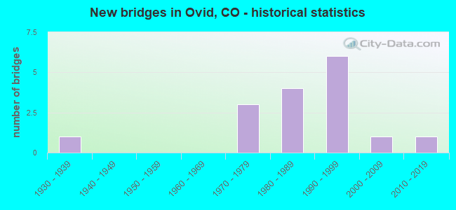
- New bridges - historical statistics
- 11930-1939
- 31970-1979
- 41980-1989
- 61990-1999
- 12000-2009
- 12010-2019


- Bridge Condition - Deck
- 31.3%Very good
- 37.5%Good
- 12.5%Satisfactory
- 18.8%Fair

- Bridge Condition - Superstructure
- 31.3%Very good
- 31.3%Good
- 31.3%Satisfactory
- 6.3%Fair

- Bridge Condition - Substructure
- 43.8%Very good
- 25.0%Good
- 18.8%Satisfactory
- 12.5%Fair

- Bridge Condition - Channel
- 21.4%Very good
- 64.3%Good
- 14.3%Satisfactory
Find on map >> Show street view
Structure Number: A-27-AE, Location: 8.2 MI SW OF JCT US 385 (Lat: 40.926686, Lng: -102.387842), Route carried "on" structure: Interstate 76A, Year Built: 1970, Status: Open, Structure Length: 4.39m (14.40ft), Average Daily Traffic: 4,000 (year 2020), Truck Traffic: 31%, Average Future Daily Traffic: 4,920 (year 2040), Design Load: HS 20+Mod, Features Intersected: COUNTY ROAD 29, Facility Carried by Structure: I 76 ML WBND
Minimum Vertical Clearance: 30+ m (98+ ft), Kilometerpoint: 276.666, Lanes on structure: 2, Lanes under structure: 2, Base Highway Network: Yes, Owner: State Highway Agency, Approaching Roadway Width: 11.6m (38.1ft), Skew: 10 degrees, Material/Design: Concrete continuous, Design/Construction: Tee Beam, Number Of Spans In Main Unit: 3, Length of Maximum Span: 17.7m (58.1ft), Curb-To-Curb Width: 12.8m (42.0ft), Out-to-Out Width: 13.6m (44.6ft)
Condition: Deck: Satisfactory, Superstructure: Satisfactory, Substructure: Satisfactory, Operating Rating: 50.6 metric tons, Method Used To Determine Operating Rating: Load Factor (LF), Inventory Rating: 30.3 metric tons, Method Used To Determine Inventory Rating: Load Factor (LF), Structural Evaluation: Equal to present minimum criteria, Deck Geometry: Equal to present desirable criteria, Underclear: Superior to present desirable criteria, Approach Roadway Alignment: Equal to present desirable criteria, Designated Inspection Frequency: Every 24 months, Inspection Date: May 2021, Deck Structure Type: Other, Wearing Surface/Protective System: Wearing Surface: Bituminous
Find on map >> Show street view
Structure Number: A-27-AF, Location: 6.9 MI NE OF JCT SH 59 (Lat: 40.925489, Lng: -102.387825), Route carried "on" structure: Interstate 76A, Year Built: 1970, Status: Open, Structure Length: 4.39m (14.40ft), Average Daily Traffic: 4,000 (year 2020), Truck Traffic: 31%, Average Future Daily Traffic: 4,920 (year 2040), Design Load: HS 20+Mod, Features Intersected: COUNTY ROAD 29, Facility Carried by Structure: I 76 ML EBND
Minimum Vertical Clearance: 30+ m (98+ ft), Kilometerpoint: 276.666, Lanes on structure: 2, Lanes under structure: 2, Base Highway Network: Yes, Owner: State Highway Agency, Approaching Roadway Width: 11.6m (38.1ft), Skew: 10 degrees, Material/Design: Concrete continuous, Design/Construction: Tee Beam, Number Of Spans In Main Unit: 3, Length of Maximum Span: 17.7m (58.1ft), Curb-To-Curb Width: 12.8m (42.0ft), Out-to-Out Width: 13.6m (44.6ft)
Condition: Deck: Fair, Superstructure: Satisfactory, Substructure: Satisfactory, Operating Rating: 50.6 metric tons, Method Used To Determine Operating Rating: Load Factor (LF), Inventory Rating: 30.3 metric tons, Method Used To Determine Inventory Rating: Load Factor (LF), Structural Evaluation: Equal to present minimum criteria, Deck Geometry: Equal to present desirable criteria, Underclear: Better than present minimum criteria, Approach Roadway Alignment: Equal to present desirable criteria, Designated Inspection Frequency: Every 24 months, Inspection Date: May 2021, Deck Structure Type: Other, Wearing Surface/Protective System: Wearing Surface: Bituminous
Find on map >> Show street view
Structure Number: A-27-M, Location: West edge of Ovid (Lat: 40.960683, Lng: -102.395133), Route carried "on" structure: US 138A, Year Built: 1930, Status: Open, Structure Length: 0.67m (2.20ft), Average Daily Traffic: 720 (year 2020), Truck Traffic: 10%, Average Future Daily Traffic: 878 (year 2040), Design Load: H 15, Features Intersected: DRAW, Facility Carried by Structure: US 138 ML
Minimum Vertical Clearance: 30+ m (98+ ft), Kilometerpoint: 80.652, Lanes on structure: 2, Owner: State Highway Agency, Approaching Roadway Width: 7.9m (25.9ft), Material/Design: Wood or Timber, Design/Construction: Stringer/Multi-beam, Number Of Spans In Main Unit: 1, Length of Maximum Span: 6.4m (21.0ft), Curb-To-Curb Width: 8.5m (27.9ft), Out-to-Out Width: 8.8m (28.9ft)
Condition: Deck: Good, Superstructure: Fair, Substructure: Fair, Channel: Satisfactory, Operating Rating: 50.5 metric tons, Method Used To Determine Operating Rating: Allowable Stress (AS), Inventory Rating: 33.4 metric tons, Method Used To Determine Inventory Rating: Allowable Stress (AS), Structural Evaluation: Somewhat better than minimum adequacy, Deck Geometry: Somewhat better than minimum adequacy, Waterway Adequacy: Somewhat better than minimum adequacy, Approach Roadway Alignment: Equal to present desirable criteria, Length Of Structure Improvement: 0.68m (2.23ft), Designated Inspection Frequency: Every 24 months, Inspection Date: March 2021, Bridge Improvement Cost: $23,000, Roadway Improvement Cost: $2,000, Total Project Cost: $34,000, Deck Structure Type: Corrugated Steel, Wearing Surface/Protective System: Wearing Surface: Bituminous
Find on map >> Show street view
Structure Number: A-27-U, Location: 7.1 MI NE OF JCT SH 59 (Lat: 40.960853, Lng: -102.384931), Route carried "on" structure: US 138A, Year Built: 2017, Status: Open, Structure Length: 1.40m (4.59ft), Average Daily Traffic: 1,000 (year 2020), Truck Traffic: 9%, Average Future Daily Traffic: 1,080 (year 2040), Design Load: HL 93, Features Intersected: LODGEPOLE CREEK, Facility Carried by Structure: US 138 ML
Minimum Vertical Clearance: 30+ m (98+ ft), Kilometerpoint: 81.513, Lanes on structure: 2, Owner: State Highway Agency, Approaching Roadway Width: 13.1m (43.0ft), Material/Design: Prestressed concrete, Design/Construction: Slab, Number Of Spans In Main Unit: 1, Length of Maximum Span: 13.0m (42.7ft), Curb-To-Curb Width: 12.2m (40.0ft), Out-to-Out Width: 13.1m (43.0ft)
Condition: Deck: Very good, Superstructure: Very good, Substructure: Very good, Channel: Very good, Operating Rating: 45.4 metric tons, Method Used To Determine Operating Rating: Load and Resistance Factor Rating (LRFR) rating reported by rating factor(RF) method using HL-93 loadings, Inventory Rating: 35.6 metric tons, Method Used To Determine Inventory Rating: Load and Resistance Factor Rating (LRFR) rating reported by rating factor(RF) method using HL-93 loadings, Structural Evaluation: Equal to present desirable criteria, Deck Geometry: Equal to present desirable criteria, Waterway Adequacy: Equal to present desirable criteria, Approach Roadway Alignment: Equal to present desirable criteria, Designated Inspection Frequency: Every 24 months, Inspection Date: March 2021, Deck Structure Type: Concrete Cast-file-Place, Wearing Surface/Protective System: Wearing Surface: Bituminous, Membrane: Built-up, Deck Protection: Epoxy Coated Reinforcing
Find on map >> Show street view
Structure Number: SED23-30.9-50-A, Location: 0.9 Mi. No. of US Hwy 138 (Lat: 40.966861, Lng: -102.440750), Route carried "on" structure: County highway , Year Built: 1996, Status: Open, Structure Length: 0.74m (2.43ft), Average Daily Traffic: 21 (year 2021), Truck Traffic: 33%, Average Future Daily Traffic: 25 (year 2041), Design Load: HS 20, Features Intersected: Peterson Ditch, Facility Carried by Structure: County Road 23
Minimum Vertical Clearance: 30+ m (98+ ft), Kilometerpoint: 1.772, Lanes on structure: 2, Owner: County Highway Agency, Approaching Roadway Width: 6.7m (22.0ft), Material/Design: Prestressed concrete, Design/Construction: Tee Beam, Number Of Spans In Main Unit: 1, Length of Maximum Span: 6.6m (21.7ft), Curb-To-Curb Width: 8.6m (28.2ft), Out-to-Out Width: 9.3m (30.5ft)
Condition: Deck: Very good, Superstructure: Very good, Substructure: Very good, Channel: Very good, Operating Rating: 33.2 metric tons, Method Used To Determine Operating Rating: Load Factor (LF), Inventory Rating: 20.0 metric tons, Method Used To Determine Inventory Rating: Load Factor (LF), Structural Evaluation: Somewhat better than minimum adequacy, Deck Geometry: Better than present minimum criteria, Waterway Adequacy: Equal to present desirable criteria, Approach Roadway Alignment: Equal to present desirable criteria, Designated Inspection Frequency: Every 24 months, Inspection Date: November 2021, Deck Structure Type: Other, Wearing Surface/Protective System: Wearing Surface: Gravel, Deck Protection: Epoxy Coated Reinforcing
Find on map >> Show street view
Structure Number: SED25-32.4-21A, Location: 0.4 Mi. No. of Co. Rd. 32 (Lat: 40.973889, Lng: -102.421611), Route carried "on" structure: County highway , Year Built: 1984, Status: Open, Structure Length: 0.70m (2.30ft), Average Daily Traffic: 13 (year 2021), Truck Traffic: 50%, Average Future Daily Traffic: 15 (year 2041), Features Intersected: Peterson Ditch, Facility Carried by Structure: County Road 25
Minimum Vertical Clearance: 30+ m (98+ ft), Kilometerpoint: 1.703, Lanes on structure: 2, Owner: County Highway Agency, Approaching Roadway Width: 6.1m (20.0ft), Skew: 1 degrees, Material/Design: Steel, Design/Construction: Stringer/Multi-beam, Number Of Spans In Main Unit: 1, Length of Maximum Span: 6.3m (20.7ft), Curb-To-Curb Width: 7.3m (24.0ft), Out-to-Out Width: 7.3m (24.0ft)
Condition: Deck: Good, Superstructure: Good, Substructure: Good, Channel: Good, Operating Rating: 40.7 metric tons, Method Used To Determine Operating Rating: Load Factor (LF), Inventory Rating: 24.4 metric tons, Method Used To Determine Inventory Rating: Load Factor (LF), Structural Evaluation: Equal to present minimum criteria, Deck Geometry: Equal to present minimum criteria, Waterway Adequacy: Better than present minimum criteria, Approach Roadway Alignment: Equal to present desirable criteria, Designated Inspection Frequency: Every 24 months, Inspection Date: November 2021, Deck Structure Type: Corrugated Steel, Wearing Surface/Protective System: Wearing Surface: Gravel
Find on map >> Show street view
Structure Number: SED27-32.9-22, Location: 0.9 Mi No. of Co. Rd. 32 (Lat: 40.981778, Lng: -102.402528), Route carried "on" structure: County highway , Year Built: 1979, Status: Open, Structure Length: 0.91m (2.99ft), Average Daily Traffic: 40 (year 2021), Truck Traffic: 67%, Average Future Daily Traffic: 48 (year 2041), Features Intersected: Peterson Ditch, Facility Carried by Structure: County Road 27
Minimum Vertical Clearance: 30+ m (98+ ft), Kilometerpoint: 2.769, Lanes on structure: 2, Owner: County Highway Agency, Approaching Roadway Width: 6.1m (20.0ft), Skew: 4 degrees, Material/Design: Steel, Design/Construction: Stringer/Multi-beam, Number Of Spans In Main Unit: 1, Length of Maximum Span: 7.2m (23.6ft), Curb-To-Curb Width: 7.4m (24.3ft), Out-to-Out Width: 7.4m (24.3ft)
Condition: Deck: Satisfactory, Superstructure: Satisfactory, Substructure: Good, Channel: Good, Operating Rating: 36.5 metric tons, Method Used To Determine Operating Rating: Load Factor (LF), Inventory Rating: 21.9 metric tons, Method Used To Determine Inventory Rating: Load Factor (LF), Structural Evaluation: Equal to present minimum criteria, Deck Geometry: Equal to present minimum criteria, Waterway Adequacy: Equal to present desirable criteria, Approach Roadway Alignment: Equal to present desirable criteria, Designated Inspection Frequency: Every 24 months, Inspection Date: November 2021, Deck Structure Type: Corrugated Steel, Wearing Surface/Protective System: Wearing Surface: Gravel
Find on map >> Show street view
Structure Number: SED27.8-28.723A, Location: 0.7 Mi. No. of Co. Rd. 28 (Lat: 40.950444, Lng: -102.387556), Route carried "on" structure: County highway , Year Built: 1986, Status: Open, Structure Length: 9.98m (32.74ft), Average Daily Traffic: 511 (year 2021), Truck Traffic: 29%, Average Future Daily Traffic: 608 (year 2041), Design Load: HS 20, Features Intersected: So. Platte Rvr. Overflow, Facility Carried by Structure: County Road 27.8
Minimum Vertical Clearance: 30+ m (98+ ft), Kilometerpoint: 22.534, Lanes on structure: 2, Owner: County Highway Agency, Approaching Roadway Width: 9.1m (29.9ft), Material/Design: Steel, Design/Construction: Stringer/Multi-beam, Number Of Spans In Main Unit: 5, Length of Maximum Span: 19.6m (64.3ft), Curb-To-Curb Width: 9.7m (31.8ft), Out-to-Out Width: 9.8m (32.2ft)
Condition: Deck: Fair, Superstructure: Satisfactory, Substructure: Satisfactory, Channel: Satisfactory, Operating Rating: 52.6 metric tons, Method Used To Determine Operating Rating: Load Factor (LF), Inventory Rating: 31.6 metric tons, Method Used To Determine Inventory Rating: Load Factor (LF), Structural Evaluation: Equal to present minimum criteria, Deck Geometry: Equal to present minimum criteria, Waterway Adequacy: Better than present minimum criteria, Approach Roadway Alignment: Equal to present desirable criteria, Designated Inspection Frequency: Every 24 months, Inspection Date: November 2021, Deck Structure Type: Corrugated Steel, Wearing Surface/Protective System: Wearing Surface: Bituminous
Find on map >> Show street view
Structure Number: SED27.8-30-24A, Location: 0.8 Mi. No. of Co. Rd. 28 (Lat: 40.953806, Lng: -102.387639), Route carried "on" structure: County highway , Year Built: 1985, Status: Open, Structure Length: 9.98m (32.74ft), Average Daily Traffic: 669 (year 2021), Truck Traffic: 29%, Average Future Daily Traffic: 796 (year 2041), Design Load: HS 20, Features Intersected: South Platte River, Facility Carried by Structure: County Road 27.8
Minimum Vertical Clearance: 30+ m (98+ ft), Kilometerpoint: 22.941, Lanes on structure: 2, Owner: County Highway Agency, Approaching Roadway Width: 9.1m (29.9ft), Material/Design: Steel, Design/Construction: Stringer/Multi-beam, Number Of Spans In Main Unit: 5, Length of Maximum Span: 19.6m (64.3ft), Curb-To-Curb Width: 9.7m (31.8ft), Out-to-Out Width: 9.8m (32.2ft)
Condition: Deck: Fair, Superstructure: Satisfactory, Substructure: Fair, Channel: Good, Operating Rating: 44.9 metric tons, Method Used To Determine Operating Rating: Load Factor (LF), Inventory Rating: 26.9 metric tons, Method Used To Determine Inventory Rating: Load Factor (LF), Structural Evaluation: Somewhat better than minimum adequacy, Deck Geometry: Equal to present minimum criteria, Waterway Adequacy: Equal to present desirable criteria, Approach Roadway Alignment: Equal to present desirable criteria, Designated Inspection Frequency: Every 24 months, Inspection Date: November 2021, Deck Structure Type: Corrugated Steel, Wearing Surface/Protective System: Wearing Surface: Bituminous
Find on map >> Show street view
Structure Number: SED27.8-30.225A, Location: 1.1 Mi. No. of Co. Rd. 30 (Lat: 40.955194, Lng: -102.387667), Route carried "on" structure: County highway , Year Built: 1987, Status: Open, Structure Length: 7.03m (23.06ft), Average Daily Traffic: 669 (year 2021), Truck Traffic: 32%, Average Future Daily Traffic: 796 (year 2041), Design Load: HS 20, Features Intersected: South Platte River, Facility Carried by Structure: County Road 27.8
Minimum Vertical Clearance: 30+ m (98+ ft), Kilometerpoint: 23.051, Lanes on structure: 2, Owner: County Highway Agency, Approaching Roadway Width: 9.1m (29.9ft), Material/Design: Prestressed concrete continuous, Design/Construction: Stringer/Multi-beam, Number Of Spans In Main Unit: 2, Length of Maximum Span: 33.9m (111.2ft), Curb-To-Curb Width: 10.4m (34.1ft), Out-to-Out Width: 11.2m (36.7ft)
Condition: Deck: Good, Superstructure: Very good, Substructure: Very good, Channel: Good, Operating Rating: 52.9 metric tons, Method Used To Determine Operating Rating: Load Factor (LF), Inventory Rating: 31.8 metric tons, Method Used To Determine Inventory Rating: Load Factor (LF), Structural Evaluation: Better than present minimum criteria, Deck Geometry: Equal to present minimum criteria, Waterway Adequacy: Equal to present desirable criteria, Approach Roadway Alignment: Equal to present desirable criteria, Designated Inspection Frequency: Every 24 months, Inspection Date: November 2021, Deck Structure Type: Concrete Cast-file-Place, Wearing Surface/Protective System: Wearing Surface: Bituminous, Membrane: Built-up, Deck Protection: Epoxy Coated Reinforcing
Find on map >> Show street view
Structure Number: SED30.4-27.9_35, Location: 0.2 M. E. of Co. Rd. 27-9 (Lat: 40.959556, Lng: -102.384722), Route carried "on" structure: County highway , Year Built: 2001, Status: Open, Structure Length: 1.16m (3.81ft), Average Daily Traffic: 50 (year 2021), Truck Traffic: 27%, Average Future Daily Traffic: 60 (year 2041), Design Load: HS 20, Features Intersected: Lodgepole Creek, Facility Carried by Structure: County Road 30.4
Minimum Vertical Clearance: 30+ m (98+ ft), Kilometerpoint: 0.043, Lanes on structure: 2, Owner: County Highway Agency, Approaching Roadway Width: 7.0m (23.0ft), Skew: 1 degrees, Material/Design: Prestressed concrete, Design/Construction: Tee Beam, Number Of Spans In Main Unit: 1, Length of Maximum Span: 10.0m (32.8ft), Curb-To-Curb Width: 9.8m (32.2ft), Out-to-Out Width: 10.6m (34.8ft)
Condition: Deck: Very good, Superstructure: Good, Substructure: Good, Channel: Good, Operating Rating: 80.9 metric tons, Method Used To Determine Operating Rating: Load Factor (LF), Inventory Rating: 48.5 metric tons, Method Used To Determine Inventory Rating: Load Factor (LF), Structural Evaluation: Better than present minimum criteria, Deck Geometry: Equal to present desirable criteria, Waterway Adequacy: Better than present minimum criteria, Approach Roadway Alignment: Equal to present desirable criteria, Designated Inspection Frequency: Every 24 months, Inspection Date: November 2021, Deck Structure Type: Other, Wearing Surface/Protective System: Wearing Surface: Gravel, Deck Protection: Epoxy Coated Reinforcing
Find on map >> Show street view
Structure Number: SED31-32.6-36-A, Location: 0.6 Mi. No. of Co. Rd. 32 (Lat: 40.977694, Lng: -102.364083), Route carried "on" structure: County highway , Year Built: 1999, Status: Open, Structure Length: 0.79m (2.59ft), Average Daily Traffic: 48 (year 2021), Truck Traffic: 32%, Average Future Daily Traffic: 57 (year 2041), Design Load: HS 20, Features Intersected: Peterson Ditch, Facility Carried by Structure: County Road 31
Minimum Vertical Clearance: 30+ m (98+ ft), Kilometerpoint: 2.313, Lanes on structure: 2, Owner: County Highway Agency, Approaching Roadway Width: 6.7m (22.0ft), Material/Design: Prestressed concrete, Design/Construction: Tee Beam, Number Of Spans In Main Unit: 1, Length of Maximum Span: 6.7m (22.0ft), Curb-To-Curb Width: 9.7m (31.8ft), Out-to-Out Width: 10.5m (34.4ft)
Condition: Deck: Good, Superstructure: Good, Substructure: Very good, Channel: Good, Operating Rating: 86.2 metric tons, Method Used To Determine Operating Rating: Load Factor (LF), Inventory Rating: 51.7 metric tons, Method Used To Determine Inventory Rating: Load Factor (LF), Structural Evaluation: Better than present minimum criteria, Deck Geometry: Better than present minimum criteria, Waterway Adequacy: Equal to present desirable criteria, Approach Roadway Alignment: Equal to present desirable criteria, Designated Inspection Frequency: Every 24 months, Inspection Date: November 2021, Deck Structure Type: Other, Wearing Surface/Protective System: Wearing Surface: Gravel, Deck Protection: Epoxy Coated Reinforcing
Find on map >> Show street view
Structure Number: SED32-23.2-37-A, Location: 0.2 Mi East of Co. Rd. 23 (Lat: 40.968472, Lng: -102.434722), Route carried "on" structure: County highway , Year Built: 1995, Status: Open, Structure Length: 1.06m (3.48ft), Average Daily Traffic: 123 (year 2021), Truck Traffic: 33%, Average Future Daily Traffic: 146 (year 2041), Design Load: HS 20, Features Intersected: Peterson Ditch, Facility Carried by Structure: County Road 32
Minimum Vertical Clearance: 30+ m (98+ ft), Kilometerpoint: 6.983, Lanes on structure: 2, Owner: County Highway Agency, Approaching Roadway Width: 6.1m (20.0ft), Material/Design: Prestressed concrete, Design/Construction: Tee Beam, Number Of Spans In Main Unit: 1, Length of Maximum Span: 9.8m (32.2ft), Curb-To-Curb Width: 9.8m (32.2ft), Out-to-Out Width: 10.5m (34.4ft)
Condition: Deck: Very good, Superstructure: Very good, Substructure: Very good, Channel: Good, Operating Rating: 48.3 metric tons, Method Used To Determine Operating Rating: Load Factor (LF), Inventory Rating: 28.9 metric tons, Method Used To Determine Inventory Rating: Load Factor (LF), Structural Evaluation: Better than present minimum criteria, Deck Geometry: Better than present minimum criteria, Waterway Adequacy: Equal to present desirable criteria, Approach Roadway Alignment: Equal to present desirable criteria, Designated Inspection Frequency: Every 24 months, Inspection Date: November 2021, Deck Structure Type: Other, Wearing Surface/Protective System: Wearing Surface: Gravel, Deck Protection: Epoxy Coated Reinforcing
Find on map >> Show street view
Structure Number: SED34-27.3-40-A, Location: 0.3 Mi. E. of Co. Rd. 34 (Lat: 40.982833, Lng: -102.395944), Route carried "on" structure: County highway , Year Built: 1996, Status: Open, Structure Length: 1.13m (3.71ft), Average Daily Traffic: 47 (year 2021), Truck Traffic: 74%, Average Future Daily Traffic: 56 (year 2041), Design Load: HS 20, Features Intersected: Peterson Ditch, Facility Carried by Structure: County Road 34
Minimum Vertical Clearance: 30+ m (98+ ft), Kilometerpoint: 7.030, Lanes on structure: 2, Owner: County Highway Agency, Approaching Roadway Width: 5.8m (19.0ft), Skew: 4 degrees, Material/Design: Prestressed concrete, Design/Construction: Tee Beam, Number Of Spans In Main Unit: 1, Length of Maximum Span: 10.1m (33.1ft), Curb-To-Curb Width: 9.8m (32.2ft), Out-to-Out Width: 10.5m (34.4ft)
Condition: Deck: Good, Superstructure: Good, Substructure: Good, Channel: Good, Operating Rating: 48.6 metric tons, Method Used To Determine Operating Rating: Load Factor (LF), Inventory Rating: 29.2 metric tons, Method Used To Determine Inventory Rating: Load Factor (LF), Structural Evaluation: Better than present minimum criteria, Deck Geometry: Equal to present desirable criteria, Waterway Adequacy: Equal to present desirable criteria, Approach Roadway Alignment: Equal to present desirable criteria, Designated Inspection Frequency: Every 24 months, Inspection Date: November 2021, Deck Structure Type: Other, Wearing Surface/Protective System: Wearing Surface: Gravel, Deck Protection: Epoxy Coated Reinforcing
Find on map >> Show street view
Structure Number: SED34-27.7-51, Location: 0.7 Mi E. of Co. Rd. 27 (Lat: 40.982778, Lng: -102.388889), Route carried "on" structure: County highway , Year Built: 1996, Status: Open, Structure Length: 1.22m (4.00ft), Average Daily Traffic: 60 (year 2021), Truck Traffic: 66%, Average Future Daily Traffic: 71 (year 2041), Design Load: HS 20, Features Intersected: Lodge Pole Creek, Facility Carried by Structure: County Road 34
Minimum Vertical Clearance: 30+ m (98+ ft), Kilometerpoint: 7.735, Lanes on structure: 2, Owner: County Highway Agency, Approaching Roadway Width: 6.1m (20.0ft), Skew: 2 degrees, Material/Design: Prestressed concrete, Design/Construction: Tee Beam, Number Of Spans In Main Unit: 1, Length of Maximum Span: 11.5m (37.7ft), Curb-To-Curb Width: 9.7m (31.8ft), Out-to-Out Width: 10.6m (34.8ft)
Condition: Deck: Very good, Superstructure: Very good, Substructure: Very good, Channel: Very good, Operating Rating: 64.6 metric tons, Method Used To Determine Operating Rating: Load Factor (LF), Inventory Rating: 40.0 metric tons, Method Used To Determine Inventory Rating: Load Factor (LF), Structural Evaluation: Equal to present desirable criteria, Deck Geometry: Better than present minimum criteria, Waterway Adequacy: Better than present minimum criteria, Approach Roadway Alignment: Equal to present desirable criteria, Designated Inspection Frequency: Every 24 months, Inspection Date: November 2021, Deck Structure Type: Other, Wearing Surface/Protective System: Wearing Surface: Gravel, Deck Protection: Epoxy Coated Reinforcing
Find on map >> Show street view
Structure Number: SED36.3-27.744A, Location: 0.7 M. East of Co. Rd. 27 (Lat: 41.002472, Lng: -102.389722), Route carried "on" structure: County highway , Year Built: 1993, Status: Open, Structure Length: 1.95m (6.40ft), Average Daily Traffic: 42 (year 2021), Truck Traffic: 42%, Average Future Daily Traffic: 50 (year 2041), Design Load: HS 20, Features Intersected: Lodgepole Creek, Facility Carried by Structure: County Road 36.3
Minimum Vertical Clearance: 30+ m (98+ ft), Kilometerpoint: 1.914, Lanes on structure: 2, Owner: County Highway Agency, Approaching Roadway Width: 5.5m (18.0ft), Material/Design: Prestressed concrete, Design/Construction: Tee Beam, Number Of Spans In Main Unit: 1, Length of Maximum Span: 17.9m (58.7ft), Curb-To-Curb Width: 9.8m (32.2ft), Out-to-Out Width: 10.5m (34.4ft)
Condition: Deck: Good, Superstructure: Good, Substructure: Very good, Channel: Good, Operating Rating: 59.3 metric tons, Method Used To Determine Operating Rating: Load Factor (LF), Inventory Rating: 35.6 metric tons, Method Used To Determine Inventory Rating: Load Factor (LF), Structural Evaluation: Better than present minimum criteria, Deck Geometry: Equal to present desirable criteria, Waterway Adequacy: Equal to present desirable criteria, Approach Roadway Alignment: Equal to present desirable criteria, Designated Inspection Frequency: Every 24 months, Inspection Date: November 2021, Deck Structure Type: Other, Wearing Surface/Protective System: Wearing Surface: Gravel, Deck Protection: Epoxy Coated Reinforcing