Bridge Statistics for Osmond, Nebraska (NE)
Condition, Traffic, Stress, Structural Evaluation, Project Costs
- National Bridge Inventory (NBI) Statistics
- 30Number of bridges
- 190ft / 57.6mTotal length
- 20,580Total average daily traffic
- 3,535Total average daily truck traffic
- 27,468Total future (year 2033) average daily traffic
- National Bridge Inventory (NBI) Registered Bridges for Osmond
- No street view available for this location
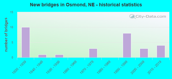
- New bridges - historical statistics
- 101930-1939
- 11940-1949
- 11950-1959
- 31970-1979
- 81990-1999
- 32000-2009
- 42010-2019

- Reconstructed bridges - Historical Statistics
- 11960-1969
- 01970-1979
- 01980-1989
- 11990-1999

- Bridge Condition - Deck
- 8.0%Very good
- 12.0%Good
- 28.0%Satisfactory
- 48.0%Fair
- 4.0%Poor

- Bridge Condition - Superstructure
- 4.0%Excellent
- 32.0%Very good
- 24.0%Good
- 36.0%Satisfactory
- 4.0%Fair

- Bridge Condition - Substructure
- 4.0%Excellent
- 32.0%Very good
- 28.0%Good
- 12.0%Satisfactory
- 24.0%Fair

- Bridge Condition - Channel
- 13.3%Excellent
- 30.0%Very good
- 23.3%Good
- 13.3%Satisfactory
- 20.0%Fair

- Bridge Condition - Culverts
- 60.0%Very good
- 20.0%Good
- 20.0%Satisfactory
Find on map >> Show street view
Structure Number: C007000805, Location: 2N 3W OF OSMOND (Lat: 42.394600, Lng: -97.657300), Route carried "on" structure: County highway 7712, Year Built: 1999, Status: Open, Structure Length: 1.55m (5.09ft), Average Daily Traffic: 50 (year 1998), Average Future Daily Traffic: 85 (year 2033), Features Intersected: W BR N FK ELKHORN RIVER
Minimum Vertical Clearance: 30+ m (98+ ft), Kilometerpoint: 0.661, Lanes on structure: 2, Owner: County Highway Agency, Approaching Roadway Width: 5.5m (18.0ft), Material/Design: Steel, Design/Construction: Stringer/Multi-beam, Number Of Spans In Main Unit: 1, Length of Maximum Span: 15.2m (49.9ft), Curb-To-Curb Width: 8.7m (28.5ft), Out-to-Out Width: 8.7m (28.5ft)
Condition: Deck: Good, Superstructure: Very good, Substructure: Very good, Channel: Very good, Operating Rating: 43.0 metric tons, Method Used To Determine Operating Rating: Load Factor (LF), Inventory Rating: 25.0 metric tons, Method Used To Determine Inventory Rating: Load Factor (LF), Structural Evaluation: Equal to present minimum criteria, Deck Geometry: Better than present minimum criteria, Waterway Adequacy: Better than present minimum criteria, Approach Roadway Alignment: Equal to present desirable criteria, Length Of Structure Improvement: 1.55m (5.09ft), Designated Inspection Frequency: Every 24 months, Inspection Date: September 2021, Deck Structure Type: Other, Wearing Surface/Protective System: Wearing Surface: Monolithic Concrete
Find on map >> Show street view
Structure Number: C00700081, Location: 2N OF OSMOND (Lat: 42.395000, Lng: -97.591700), Route carried "on" structure: County highway 8, Year Built: 2011, Status: Open, Structure Length: 1.16m (3.81ft), Average Daily Traffic: 10 (year 2003), Average Future Daily Traffic: 17 (year 2033), Design Load: HL 93, Features Intersected: N FK ELKHORN RIVER, Facility Carried by Structure: COUNTY HIGHWAY
Minimum Vertical Clearance: 30+ m (98+ ft), Kilometerpoint: 0.000, Lanes on structure: 2, Owner: County Highway Agency, Approaching Roadway Width: 8.5m (27.9ft), Material/Design: Concrete, Design/Construction: Culvert, Number Of Spans In Main Unit: 3, Length of Maximum Span: 3.7m (12.1ft)
Condition: Channel: Good, Culverts: Very good, Operating Rating: 59.0 metric tons, Method Used To Determine Operating Rating: Field evaluation and documented engineering judgment, Inventory Rating: 45.0 metric tons, Method Used To Determine Inventory Rating: Field evaluation and documented engineering judgment, Structural Evaluation: Equal to present desirable criteria, Waterway Adequacy: Equal to present desirable criteria, Approach Roadway Alignment: Equal to present desirable criteria, Length Of Structure Improvement: 1.92m (6.30ft), Designated Inspection Frequency: Every 24 months, Inspection Date: August 2020
Find on map >> Show street view
Structure Number: C007001015, Location: 1N OF OSMOND (Lat: 42.380100, Lng: -97.591600), Route carried "on" structure: County highway 10, Year Built: 1935, Status: Posted for load, Structure Length: 0.98m (3.22ft), Average Daily Traffic: 20 (year 2003), Average Future Daily Traffic: 34 (year 2033), Features Intersected: N FK ELKHORN RIVER, Facility Carried by Structure: COUNTY HIGHWAY
Minimum Vertical Clearance: 30+ m (98+ ft), Kilometerpoint: 0.000, Lanes on structure: 1, Owner: County Highway Agency, Approaching Roadway Width: 5.2m (17.1ft), Material/Design: Steel, Design/Construction: Stringer/Multi-beam, Number Of Spans In Main Unit: 1, Length of Maximum Span: 9.1m (29.9ft), Curb-To-Curb Width: 4.9m (16.1ft), Out-to-Out Width: 4.9m (16.1ft)
Condition: Deck: Satisfactory, Superstructure: Fair, Substructure: Fair, Channel: Fair, Operating Rating: 18.0 metric tons, Method Used To Determine Operating Rating: Load Factor (LF), Inventory Rating: 11.0 metric tons, Method Used To Determine Inventory Rating: Load Factor (LF), Structural Evaluation: Meets minimum limits, Deck Geometry: High priority of corrective action, Waterway Adequacy: Somewhat better than minimum adequacy, Approach Roadway Alignment: Somewhat better than minimum adequacy, Bridge Posting: Required (Relationship of Operating Rating to Maximum Legal Load: > 39.9% below), Length Of Structure Improvement: 0.98m (3.22ft), Designated Inspection Frequency: Every 24 months, Inspection Date: September 2021, Deck Structure Type: Other, Wearing Surface/Protective System: Wearing Surface: Monolithic Concrete
Find on map >> Show street view
Structure Number: C00700102, Location: 2.7E 1N OF OSMOND (Lat: 42.380000, Lng: -97.536700), Route carried "on" structure: County highway 10, Year Built: 1935, Status: Open, Structure Length: 0.98m (3.22ft), Average Daily Traffic: 50 (year 2003), Average Future Daily Traffic: 85 (year 2033), Features Intersected: E BR N FK ELKHORN RIVER, Facility Carried by Structure: COUNTY HIGHWAY
Minimum Vertical Clearance: 30+ m (98+ ft), Kilometerpoint: 0.000, Lanes on structure: 2, Owner: County Highway Agency, Approaching Roadway Width: 4.9m (16.1ft), Material/Design: Steel, Design/Construction: Stringer/Multi-beam, Number Of Spans In Main Unit: 1, Length of Maximum Span: 9.1m (29.9ft), Curb-To-Curb Width: 4.9m (16.1ft), Out-to-Out Width: 4.9m (16.1ft)
Condition: Deck: Fair, Superstructure: Good, Substructure: Satisfactory, Channel: Good, Operating Rating: 41.0 metric tons, Method Used To Determine Operating Rating: Load Factor (LF), Inventory Rating: 24.0 metric tons, Method Used To Determine Inventory Rating: Load Factor (LF), Structural Evaluation: Equal to present minimum criteria, Deck Geometry: High priority of corrective action, Waterway Adequacy: Better than present minimum criteria, Approach Roadway Alignment: Equal to present desirable criteria, Length Of Structure Improvement: 0.98m (3.22ft), Designated Inspection Frequency: Every 24 months, Inspection Date: September 2021, Deck Structure Type: Other, Wearing Surface/Protective System: Wearing Surface: Monolithic Concrete
Find on map >> Show street view
Structure Number: C007001215, Location: 1.2W OF OSMOND (Lat: 42.365600, Lng: -97.631400), Route carried "on" structure: County highway 7712, Year Built: 1935, Status: Posted for load, Structure Length: 1.55m (5.09ft), Average Daily Traffic: 100 (year 1998), Average Future Daily Traffic: 170 (year 2033), Features Intersected: W BR N FK ELKHORN RIVER, Facility Carried by Structure: 865 ROAD
Minimum Vertical Clearance: 30+ m (98+ ft), Kilometerpoint: 1.210, Lanes on structure: 2, Owner: County Highway Agency, Approaching Roadway Width: 6.1m (20.0ft), Material/Design: Steel, Design/Construction: Truss - Thru, Number Of Spans In Main Unit: 1, Length of Maximum Span: 14.9m (48.9ft), Curb or Sidewalk Widths: Left: 0.2m (0.7ft), Right: 0.2m (0.7ft), Curb-To-Curb Width: 5.8m (19.0ft), Out-to-Out Width: 6.1m (20.0ft)
Condition: Deck: Poor, Superstructure: Satisfactory, Substructure: Fair, Channel: Fair, Operating Rating: 13.0 metric tons, Method Used To Determine Operating Rating: Load Factor (LF), Inventory Rating: 8.0 metric tons, Method Used To Determine Inventory Rating: Load Factor (LF), Structural Evaluation: High priority of replacement, Deck Geometry: Meets minimum limits, Waterway Adequacy: Equal to present minimum criteria, Approach Roadway Alignment: Better than present minimum criteria, Bridge Posting: Required (Relationship of Operating Rating to Maximum Legal Load: > 39.9% below), Length Of Structure Improvement: 1.55m (5.09ft), Designated Inspection Frequency: Every 24 months, Critical Feature Inspection Frequency: Every 24 months, Inspection Date: September 2021, Critical Feature Inspection Date: September 2021, Deck Structure Type: Other, Wearing Surface/Protective System: Wearing Surface: Monolithic Concrete
Find on map >> Show street view
Structure Number: C00700122, Location: .2E OF OSMOND (Lat: 42.365000, Lng: -97.585000), Route carried "on" structure: County highway 12, Year Built: 1935, Status: Posted for load, Structure Length: 1.86m (6.10ft), Average Daily Traffic: 100 (year 2003), Truck Traffic: 10%, Average Future Daily Traffic: 170 (year 2033), Features Intersected: N FK ELKHORN RIVER, Facility Carried by Structure: COUNTY HIGHWAY
Minimum Vertical Clearance: 30+ m (98+ ft), Kilometerpoint: 0.000, Lanes on structure: 2, Owner: County Highway Agency, Approaching Roadway Width: 7.0m (23.0ft), Material/Design: Steel, Design/Construction: Stringer/Multi-beam, Number Of Spans In Main Unit: 1, Length of Maximum Span: 18.0m (59.1ft), Curb-To-Curb Width: 7.9m (25.9ft), Out-to-Out Width: 7.9m (25.9ft)
Condition: Deck: Fair, Superstructure: Good, Substructure: Good, Channel: Satisfactory, Operating Rating: 25.0 metric tons, Method Used To Determine Operating Rating: Load Factor (LF), Inventory Rating: 15.0 metric tons, Method Used To Determine Inventory Rating: Load Factor (LF), Structural Evaluation: Meets minimum limits, Deck Geometry: Equal to present minimum criteria, Waterway Adequacy: Somewhat better than minimum adequacy, Approach Roadway Alignment: Equal to present desirable criteria, Bridge Posting: Required (Relationship of Operating Rating to Maximum Legal Load: 30.0 - 39.9% below), Designated Inspection Frequency: Every 24 months, Inspection Date: September 2021, Deck Structure Type: Other, Wearing Surface/Protective System: Wearing Surface: Monolithic Concrete
Find on map >> Show street view
Structure Number: C00700181, Location: 2S .5W OF OSMOND (Lat: 42.321700, Lng: -97.615000), Route carried "on" structure: County highway 18, Year Built: 1979, Status: Open, Structure Length: 1.86m (6.10ft), Average Daily Traffic: 40 (year 2003), Average Future Daily Traffic: 68 (year 2033), Features Intersected: N FK ELKHORN RIVER, Facility Carried by Structure: COUNTY HIGHWAY
Minimum Vertical Clearance: 30+ m (98+ ft), Kilometerpoint: 0.000, Lanes on structure: 2, Owner: County Highway Agency, Approaching Roadway Width: 5.2m (17.1ft), Material/Design: Steel, Design/Construction: Stringer/Multi-beam, Number Of Spans In Main Unit: 1, Length of Maximum Span: 18.0m (59.1ft), Curb-To-Curb Width: 7.3m (24.0ft), Out-to-Out Width: 7.3m (24.0ft)
Condition: Deck: Fair, Superstructure: Very good, Substructure: Good, Channel: Satisfactory, Operating Rating: 42.0 metric tons, Method Used To Determine Operating Rating: Load Factor (LF), Inventory Rating: 25.0 metric tons, Method Used To Determine Inventory Rating: Load Factor (LF), Structural Evaluation: Equal to present minimum criteria, Deck Geometry: Equal to present minimum criteria, Waterway Adequacy: Better than present minimum criteria, Approach Roadway Alignment: Equal to present desirable criteria, Designated Inspection Frequency: Every 24 months, Inspection Date: September 2021, Deck Structure Type: Other, Wearing Surface/Protective System: Wearing Surface: Monolithic Concrete
Find on map >> Show street view
Structure Number: C007002015, Location: 3S OF OSMOND (Lat: 42.307900, Lng: -97.607400), Route carried "on" structure: County highway 20, Year Built: 1935, Status: Posted for load, Structure Length: 1.83m (6.00ft), Average Daily Traffic: 25 (year 2003), Average Future Daily Traffic: 42 (year 2033), Features Intersected: N FK ELKHORN RIVER, Facility Carried by Structure: COUNTY HIGHWAY
Minimum Vertical Clearance: 30+ m (98+ ft), Kilometerpoint: 0.000, Lanes on structure: 2, Owner: County Highway Agency, Approaching Roadway Width: 6.1m (20.0ft), Material/Design: Steel, Design/Construction: Stringer/Multi-beam, Number Of Spans In Main Unit: 1, Length of Maximum Span: 17.7m (58.1ft), Curb-To-Curb Width: 6.1m (20.0ft), Out-to-Out Width: 6.1m (20.0ft)
Condition: Deck: Fair, Superstructure: Good, Substructure: Fair, Channel: Satisfactory, Operating Rating: 22.0 metric tons, Method Used To Determine Operating Rating: Load Factor (LF), Inventory Rating: 14.0 metric tons, Method Used To Determine Inventory Rating: Load Factor (LF), Structural Evaluation: Meets minimum limits, Deck Geometry: Somewhat better than minimum adequacy, Waterway Adequacy: Better than present minimum criteria, Approach Roadway Alignment: Meets minimum limits, Bridge Posting: Required (Relationship of Operating Rating to Maximum Legal Load: 30.0 - 39.9% below), Length Of Structure Improvement: 1.83m (6.00ft), Designated Inspection Frequency: Every 24 months, Inspection Date: September 2021, Deck Structure Type: Other, Wearing Surface/Protective System: Wearing Surface: Monolithic Concrete
Find on map >> Show street view
Structure Number: C007002215, Location: 4S OF OSMOND (Lat: 42.293300, Lng: -97.593300), Route carried "on" structure: County highway 22, Year Built: 1991, Status: Open, Structure Length: 3.14m (10.30ft), Average Daily Traffic: 35 (year 2003), Average Future Daily Traffic: 59 (year 2033), Design Load: HS 20, Features Intersected: N FK ELKHORN RIVER, Facility Carried by Structure: COUNTY HIGHWAY
Minimum Vertical Clearance: 30+ m (98+ ft), Kilometerpoint: 0.000, Lanes on structure: 2, Owner: County Highway Agency, Approaching Roadway Width: 8.5m (27.9ft), Skew: 2 degrees, Material/Design: Prestressed concrete, Design/Construction: Tee Beam, Number Of Spans In Main Unit: 3, Length of Maximum Span: 12.5m (41.0ft), Curb-To-Curb Width: 8.5m (27.9ft), Out-to-Out Width: 9.2m (30.2ft)
Condition: Deck: Very good, Superstructure: Very good, Substructure: Very good, Channel: Excellent, Operating Rating: 60.0 metric tons, Method Used To Determine Operating Rating: Load Factor (LF), Inventory Rating: 35.0 metric tons, Method Used To Determine Inventory Rating: Load Factor (LF), Structural Evaluation: Equal to present desirable criteria, Deck Geometry: Better than present minimum criteria, Waterway Adequacy: Superior to present desirable criteria, Approach Roadway Alignment: Equal to present desirable criteria, Designated Inspection Frequency: Every 24 months, Inspection Date: September 2021, Deck Structure Type: Concrete Cast-file-Place, Wearing Surface/Protective System: Wearing Surface: Monolithic Concrete
Find on map >> Show street view
Structure Number: C00701042, Location: 4.5N 1.2E OF OSMOND (Lat: 42.423300, Lng: -97.576700), Route carried "on" structure: County highway 104, Year Built: 2013, Status: Open, Structure Length: 1.16m (3.81ft), Average Daily Traffic: 55 (year 2003), Average Future Daily Traffic: 93 (year 2033), Design Load: HL 93, Features Intersected: N FK ELKHORN RIVER, Facility Carried by Structure: COUNTY HIGHWAY
Minimum Vertical Clearance: 30+ m (98+ ft), Kilometerpoint: 0.000, Lanes on structure: 2, Owner: County Highway Agency, Approaching Roadway Width: 7.0m (23.0ft), Skew: 3 degrees, Material/Design: Concrete, Design/Construction: Culvert, Number Of Spans In Main Unit: 3, Length of Maximum Span: 3.7m (12.1ft)
Condition: Channel: Good, Culverts: Very good, Operating Rating: 59.0 metric tons, Method Used To Determine Operating Rating: Load and Resistance Factor (LRFR), Inventory Rating: 45.0 metric tons, Method Used To Determine Inventory Rating: Load and Resistance Factor (LRFR), Structural Evaluation: Equal to present desirable criteria, Waterway Adequacy: Equal to present desirable criteria, Approach Roadway Alignment: Better than present minimum criteria, Length Of Structure Improvement: 1.40m (4.59ft), Designated Inspection Frequency: Every 24 months, Inspection Date: August 2020
Find on map >> Show street view
Structure Number: C00701211, Location: 1.7SW OF OSMOND (Lat: 42.340000, Lng: -97.640000), Route carried "on" structure: County highway 121, Year Built: 1998, Status: Open, Structure Length: 0.98m (3.22ft), Average Daily Traffic: 35 (year 2003), Average Future Daily Traffic: 59 (year 2033), Design Load: HS 20, Features Intersected: BRESLAU CREEK, Facility Carried by Structure: COUNTY HIGHWAY
Minimum Vertical Clearance: 30+ m (98+ ft), Kilometerpoint: 0.000, Lanes on structure: 2, Owner: County Highway Agency, Approaching Roadway Width: 5.5m (18.0ft), Material/Design: Concrete, Design/Construction: Stringer/Multi-beam, Number Of Spans In Main Unit: 1, Length of Maximum Span: 9.4m (30.8ft), Curb-To-Curb Width: 7.3m (24.0ft), Out-to-Out Width: 7.3m (24.0ft)
Condition: Deck: Fair, Superstructure: Very good, Substructure: Very good, Channel: Very good, Operating Rating: 59.0 metric tons, Method Used To Determine Operating Rating: Load Factor (LF), Inventory Rating: 35.0 metric tons, Method Used To Determine Inventory Rating: Load Factor (LF), Structural Evaluation: Equal to present desirable criteria, Deck Geometry: Equal to present minimum criteria, Waterway Adequacy: Equal to present desirable criteria, Approach Roadway Alignment: Equal to present desirable criteria, Length Of Structure Improvement: 0.98m (3.22ft), Designated Inspection Frequency: Every 24 months, Inspection Date: August 2020, Deck Structure Type: Concrete Precast Panels, Wearing Surface/Protective System: Wearing Surface: Monolithic Concrete
Find on map >> Show street view
Structure Number: C007012115, Location: EJCT US20/N121 5W .3N (Lat: 42.371500, Lng: -97.640300), Route carried "on" structure: County highway 2945, Year Built: 1975, Status: Open, Structure Length: 1.80m (5.91ft), Average Daily Traffic: 785 (year 2011), Average Future Daily Traffic: 525 (year 2033), Features Intersected: W BR N FK ELKHORN RIVER
Minimum Vertical Clearance: 30+ m (98+ ft), Kilometerpoint: 2.057, Lanes on structure: 2, Owner: County Highway Agency, Approaching Roadway Width: 9.8m (32.2ft), Skew: 4 degrees, Material/Design: Concrete, Design/Construction: Culvert, Number Of Spans In Main Unit: 4, Length of Maximum Span: 3.0m (9.8ft)
Condition: Channel: Satisfactory, Culverts: Satisfactory, Operating Rating: 33.0 metric tons, Method Used To Determine Operating Rating: Field evaluation and documented engineering judgment, Inventory Rating: 22.0 metric tons, Method Used To Determine Inventory Rating: Field evaluation and documented engineering judgment, Structural Evaluation: Somewhat better than minimum adequacy, Waterway Adequacy: Equal to present minimum criteria, Approach Roadway Alignment: Equal to present desirable criteria, Designated Inspection Frequency: Every 24 months, Inspection Date: August 2020
Find on map >> Show street view
Structure Number: C007012725, Location: .7NE OF OSMOND (Lat: 42.368000, Lng: -97.582200), Route carried "on" structure: County highway 127, Year Built: 1935, Status: Posted for load, Structure Length: 1.89m (6.20ft), Average Daily Traffic: 80 (year 2003), Average Future Daily Traffic: 136 (year 2033), Features Intersected: N FK ELKHORN RIVER, Facility Carried by Structure: 547 AVE
Minimum Vertical Clearance: 30+ m (98+ ft), Kilometerpoint: 0.000, Lanes on structure: 1, Owner: County Highway Agency, Approaching Roadway Width: 5.5m (18.0ft), Material/Design: Steel, Design/Construction: Truss - Thru, Number Of Spans In Main Unit: 1, Length of Maximum Span: 18.0m (59.1ft), Curb-To-Curb Width: 4.7m (15.4ft), Out-to-Out Width: 4.8m (15.7ft)
Condition: Deck: Fair, Superstructure: Satisfactory, Substructure: Fair, Channel: Fair, Operating Rating: 18.0 metric tons, Method Used To Determine Operating Rating: Load Factor (LF), Inventory Rating: 11.0 metric tons, Method Used To Determine Inventory Rating: Load Factor (LF), Structural Evaluation: Meets minimum limits, Deck Geometry: Better than present minimum criteria, Waterway Adequacy: Equal to present minimum criteria, Approach Roadway Alignment: Equal to present minimum criteria, Bridge Posting: Required (Relationship of Operating Rating to Maximum Legal Load: > 39.9% below), Length Of Structure Improvement: 1.89m (6.20ft), Designated Inspection Frequency: Every 24 months, Critical Feature Inspection Frequency: Every 24 months, Inspection Date: September 2021, Critical Feature Inspection Date: September 2021, Deck Structure Type: Concrete Cast-file-Place, Wearing Surface/Protective System: Wearing Surface: Monolithic Concrete
Find on map >> Show street view
Structure Number: C00701273, Location: 1NE OF OSMOND (Lat: 42.375000, Lng: -97.581700), Route carried "on" structure: County highway 127, Year Built: 1935, Status: Posted for load, Structure Length: 1.10m (3.61ft), Average Daily Traffic: 80 (year 2003), Average Future Daily Traffic: 136 (year 2033), Features Intersected: N FK ELKHORN RIVER, Facility Carried by Structure: COUNTY HIGHWAY
Minimum Vertical Clearance: 30+ m (98+ ft), Kilometerpoint: 0.000, Lanes on structure: 2, Owner: County Highway Agency, Approaching Roadway Width: 5.8m (19.0ft), Material/Design: Steel, Design/Construction: Stringer/Multi-beam, Number Of Spans In Main Unit: 1, Length of Maximum Span: 10.7m (35.1ft), Curb-To-Curb Width: 6.2m (20.3ft), Out-to-Out Width: 6.2m (20.3ft)
Condition: Deck: Fair, Superstructure: Good, Substructure: Fair, Channel: Fair, Operating Rating: 33.0 metric tons, Method Used To Determine Operating Rating: Load Factor (LF), Inventory Rating: 19.0 metric tons, Method Used To Determine Inventory Rating: Load Factor (LF), Structural Evaluation: Somewhat better than minimum adequacy, Deck Geometry: Somewhat better than minimum adequacy, Waterway Adequacy: Better than present minimum criteria, Approach Roadway Alignment: Equal to present desirable criteria, Bridge Posting: Required (Relationship of Operating Rating to Maximum Legal Load: 10.0 - 19.9% below), Designated Inspection Frequency: Every 24 months, Inspection Date: September 2021, Deck Structure Type: Other, Wearing Surface/Protective System: Wearing Surface: Monolithic Concrete
Find on map >> Show street view
Structure Number: C007012735, Location: 3N OF OSMOND (Lat: 42.406700, Lng: -97.583300), Route carried "on" structure: County highway 127, Year Built: 1990, Status: Open, Structure Length: 1.55m (5.09ft), Average Daily Traffic: 50 (year 2003), Average Future Daily Traffic: 85 (year 2033), Features Intersected: N FK ELKHORN RIVER, Facility Carried by Structure: COUNTY HIGHWAY
Minimum Vertical Clearance: 30+ m (98+ ft), Kilometerpoint: 0.000, Lanes on structure: 2, Owner: County Highway Agency, Approaching Roadway Width: 6.1m (20.0ft), Material/Design: Steel, Design/Construction: Stringer/Multi-beam, Number Of Spans In Main Unit: 1, Length of Maximum Span: 15.2m (49.9ft), Curb-To-Curb Width: 7.9m (25.9ft), Out-to-Out Width: 8.1m (26.6ft)
Condition: Deck: Fair, Superstructure: Very good, Substructure: Very good, Channel: Good, Operating Rating: 43.0 metric tons, Method Used To Determine Operating Rating: Load Factor (LF), Inventory Rating: 25.0 metric tons, Method Used To Determine Inventory Rating: Load Factor (LF), Structural Evaluation: Equal to present minimum criteria, Deck Geometry: Equal to present minimum criteria, Waterway Adequacy: Equal to present desirable criteria, Approach Roadway Alignment: Equal to present desirable criteria, Designated Inspection Frequency: Every 24 months, Inspection Date: August 2020, Deck Structure Type: Concrete Cast-file-Place, Wearing Surface/Protective System: Wearing Surface: Monolithic Concrete
Find on map >> Show street view
Structure Number: C007013125, Location: 2.5E OF OSMOND (Lat: 42.364400, Lng: -97.543200), Route carried "on" structure: County highway 131, Year Built: 1935, Status: Closed, Structure Length: 2.19m (7.19ft), Average Daily Traffic: 40 (year 2003), Average Future Daily Traffic: 68 (year 2033), Features Intersected: E BR N FK ELKHORN RIVER, Facility Carried by Structure: 549 AVE
Minimum Vertical Clearance: 30+ m (98+ ft), Kilometerpoint: 0.000, Lanes on structure: 1, Owner: County Highway Agency, Approaching Roadway Width: 7.3m (24.0ft), Material/Design: Steel, Design/Construction: Truss - Thru, Number Of Spans In Main Unit: 1, Length of Maximum Span: 21.0m (68.9ft), Curb-To-Curb Width: 4.7m (15.4ft), Out-to-Out Width: 5.0m (16.4ft)
Condition: Deck: Fair, Superstructure: Satisfactory, Substructure: Fair, Channel: Good, Deck Geometry: Better than present minimum criteria, Waterway Adequacy: Equal to present minimum criteria, Approach Roadway Alignment: Equal to present minimum criteria, Bridge Posting: Required (Relationship of Operating Rating to Maximum Legal Load: > 39.9% below), Length Of Structure Improvement: 2.19m (7.19ft), Designated Inspection Frequency: Every 24 months, Critical Feature Inspection Frequency: Every 24 months, Inspection Date: September 2017, Critical Feature Inspection Date: September 2017, Deck Structure Type: Concrete Cast-file-Place, Wearing Surface/Protective System: Wearing Surface: Monolithic Concrete
Find on map >> Show street view
Structure Number: C00702192, Location: WJCT US20/N121 2.8W .6S (Lat: 42.344300, Lng: -97.659900), Route carried "on" structure: County highway 2945, Year Built: 1977, Status: Open, Structure Length: 1.22m (4.00ft), Average Daily Traffic: 45 (year 2011), Average Future Daily Traffic: 60 (year 2033), Features Intersected: BRESLAU CREEK
Minimum Vertical Clearance: 30+ m (98+ ft), Kilometerpoint: 1.592, Lanes on structure: 2, Owner: County Highway Agency, Approaching Roadway Width: 5.5m (18.0ft), Material/Design: Steel, Design/Construction: Stringer/Multi-beam, Number Of Spans In Main Unit: 1, Length of Maximum Span: 11.9m (39.0ft), Curb-To-Curb Width: 7.9m (25.9ft), Out-to-Out Width: 7.9m (25.9ft)
Condition: Deck: Fair, Superstructure: Very good, Substructure: Very good, Channel: Very good, Operating Rating: 40.0 metric tons, Method Used To Determine Operating Rating: Load Factor (LF), Inventory Rating: 24.0 metric tons, Method Used To Determine Inventory Rating: Load Factor (LF), Structural Evaluation: Equal to present minimum criteria, Deck Geometry: Equal to present minimum criteria, Waterway Adequacy: Equal to present desirable criteria, Approach Roadway Alignment: Equal to present desirable criteria, Designated Inspection Frequency: Every 24 months, Inspection Date: August 2020, Deck Structure Type: Concrete Cast-file-Place, Wearing Surface/Protective System: Wearing Surface: Monolithic Concrete
Find on map >> Show street view
Structure Number: C007022305, Location: 3S 1W OSMOND (Lat: 42.306700, Lng: -97.620000), Route carried "on" structure: County highway 223, Year Built: 1995, Status: Open, Structure Length: 0.94m (3.08ft), Average Daily Traffic: 40 (year 2003), Average Future Daily Traffic: 68 (year 2033), Design Load: HS 20, Features Intersected: STREAM, Facility Carried by Structure: COUNTY HIGHWAY
Minimum Vertical Clearance: 30+ m (98+ ft), Kilometerpoint: 0.000, Lanes on structure: 2, Owner: County Highway Agency, Approaching Roadway Width: 5.8m (19.0ft), Material/Design: Concrete, Design/Construction: Stringer/Multi-beam, Number Of Spans In Main Unit: 1, Length of Maximum Span: 9.1m (29.9ft), Curb-To-Curb Width: 7.6m (24.9ft), Out-to-Out Width: 7.8m (25.6ft)
Condition: Deck: Fair, Superstructure: Very good, Substructure: Very good, Channel: Excellent, Operating Rating: 33.0 metric tons, Method Used To Determine Operating Rating: Field evaluation and documented engineering judgment, Inventory Rating: 22.0 metric tons, Method Used To Determine Inventory Rating: Field evaluation and documented engineering judgment, Structural Evaluation: Equal to present minimum criteria, Deck Geometry: Equal to present minimum criteria, Waterway Adequacy: Equal to present desirable criteria, Approach Roadway Alignment: Equal to present desirable criteria, Length Of Structure Improvement: 0.94m (3.08ft), Designated Inspection Frequency: Every 24 months, Inspection Date: August 2020, Deck Structure Type: Concrete Precast Panels, Wearing Surface/Protective System: Wearing Surface: Monolithic Concrete
Find on map >> Show street view
Structure Number: C00702231, Location: 1.5S 1W OF OSMOND (Lat: 42.330000, Lng: -97.620000), Route carried "on" structure: County highway 223, Year Built: 2004, Status: Open, Structure Length: 2.90m (9.51ft), Average Daily Traffic: 25 (year 2003), Average Future Daily Traffic: 42 (year 2033), Design Load: HS 20, Features Intersected: N FK ELKHORN RIVER, Facility Carried by Structure: COUNTY HIGHWAY
Minimum Vertical Clearance: 30+ m (98+ ft), Kilometerpoint: 0.000, Lanes on structure: 2, Owner: County Highway Agency, Approaching Roadway Width: 5.5m (18.0ft), Skew: 3 degrees, Material/Design: Concrete, Design/Construction: Stringer/Multi-beam, Number Of Spans In Main Unit: 3, Length of Maximum Span: 9.8m (32.2ft), Curb-To-Curb Width: 8.5m (27.9ft), Out-to-Out Width: 8.6m (28.2ft)
Condition: Deck: Fair, Superstructure: Excellent, Substructure: Excellent, Channel: Good, Operating Rating: 76.0 metric tons, Method Used To Determine Operating Rating: Load Factor (LF), Inventory Rating: 45.0 metric tons, Method Used To Determine Inventory Rating: Load Factor (LF), Structural Evaluation: Superior to present desirable criteria, Deck Geometry: Better than present minimum criteria, Waterway Adequacy: Better than present minimum criteria, Approach Roadway Alignment: Equal to present desirable criteria, Designated Inspection Frequency: Every 24 months, Inspection Date: August 2020, Deck Structure Type: Concrete Precast Panels, Wearing Surface/Protective System: Wearing Surface: Monolithic Concrete
Find on map >> Show street view
Structure Number: M1870C2505, Location: OSMOND STATE @ CHESTNUT (Lat: 42.351800, Lng: -97.596900), Route carried "on" structure: City street C25, Year Built: 1935, Status: Posted for load, Structure Length: 1.71m (5.61ft), Average Daily Traffic: 100 (year 2003), Truck Traffic: 10%, Average Future Daily Traffic: 135 (year 2033), Features Intersected: N FK ELKHORN RIVER, Facility Carried by Structure: STATE STREET
Minimum Vertical Clearance: 30+ m (98+ ft), Kilometerpoint: 0.000, Lanes on structure: 2, Owner: City or Municipal Highway Agency, Approaching Roadway Width: 5.2m (17.1ft), Material/Design: Steel, Design/Construction: Stringer/Multi-beam, Number Of Spans In Main Unit: 2, Length of Maximum Span: 8.2m (26.9ft), Curb-To-Curb Width: 6.0m (19.7ft), Out-to-Out Width: 6.1m (20.0ft)
Condition: Deck: Satisfactory, Superstructure: Satisfactory, Substructure: Satisfactory, Channel: Fair, Operating Rating: 25.0 metric tons, Method Used To Determine Operating Rating: Load Factor (LF), Inventory Rating: 15.0 metric tons, Method Used To Determine Inventory Rating: Load Factor (LF), Structural Evaluation: Meets minimum limits, Deck Geometry: Meets minimum limits, Waterway Adequacy: Better than present minimum criteria, Approach Roadway Alignment: Equal to present desirable criteria, Bridge Posting: Required (Relationship of Operating Rating to Maximum Legal Load: 30.0 - 39.9% below), Length Of Structure Improvement: 1.71m (5.61ft), Designated Inspection Frequency: Every 24 months, Inspection Date: October 2021, Deck Structure Type: Concrete Cast-file-Place, Wearing Surface/Protective System: Wearing Surface: Other
Find on map >> Show street view
Structure Number: M1870C251, Location: OSMOND STATE @ CHESTNUT (Lat: 42.352700, Lng: -97.596900), Route carried "on" structure: City street C25, Year Built: 1935, Status: Posted for load, Structure Length: 0.73m (2.40ft), Average Daily Traffic: 100 (year 2003), Truck Traffic: 10%, Average Future Daily Traffic: 135 (year 2033), Features Intersected: STREAM, Facility Carried by Structure: STATE STREET
Minimum Vertical Clearance: 30+ m (98+ ft), Kilometerpoint: 0.000, Lanes on structure: 2, Owner: City or Municipal Highway Agency, Approaching Roadway Width: 6.4m (21.0ft), Material/Design: Steel, Design/Construction: Stringer/Multi-beam, Number Of Spans In Main Unit: 1, Length of Maximum Span: 6.7m (22.0ft), Curb-To-Curb Width: 6.0m (19.7ft), Out-to-Out Width: 6.0m (19.7ft)
Condition: Deck: Satisfactory, Superstructure: Satisfactory, Substructure: Satisfactory, Channel: Excellent, Operating Rating: 19.0 metric tons, Method Used To Determine Operating Rating: Load Factor (LF), Inventory Rating: 11.0 metric tons, Method Used To Determine Inventory Rating: Load Factor (LF), Structural Evaluation: Meets minimum limits, Deck Geometry: Meets minimum limits, Waterway Adequacy: Somewhat better than minimum adequacy, Approach Roadway Alignment: Equal to present desirable criteria, Bridge Posting: Required (Relationship of Operating Rating to Maximum Legal Load: > 39.9% below), Length Of Structure Improvement: 0.73m (2.40ft), Designated Inspection Frequency: Every 24 months, Inspection Date: October 2021, Deck Structure Type: Concrete Cast-file-Place, Wearing Surface/Protective System: Wearing Surface: Other
Find on map >> Show street view
Structure Number: S020 36326, Location: 2W OSMOND (Lat: 42.351100, Lng: -97.631100), Route carried "on" structure: US 20, Year Built: 1992, Status: Open, Structure Length: 3.41m (11.19ft), Average Daily Traffic: 2,570 (year 2018), Truck Traffic: 20%, Average Future Daily Traffic: 3,341 (year 2038), Design Load: HS 20, Features Intersected: W BR N FK ELKHORN RIVER
Minimum Vertical Clearance: 30+ m (98+ ft), Kilometerpoint: 58.461, Lanes on structure: 2, Base Highway Network: Yes, Owner: State Highway Agency, Approaching Roadway Width: 12.2m (40.0ft), Material/Design: Concrete continuous, Design/Construction: Slab, Number Of Spans In Main Unit: 3, Length of Maximum Span: 13.4m (44.0ft), Curb-To-Curb Width: 13.4m (44.0ft), Out-to-Out Width: 14.1m (46.3ft)
Condition: Deck: Satisfactory, Superstructure: Satisfactory, Substructure: Good, Channel: Very good, Operating Rating: 81.0 metric tons, Method Used To Determine Operating Rating: Load Factor (LF), Inventory Rating: 48.0 metric tons, Method Used To Determine Inventory Rating: Load Factor (LF), Structural Evaluation: Equal to present minimum criteria, Deck Geometry: Better than present minimum criteria, Waterway Adequacy: Equal to present desirable criteria, Approach Roadway Alignment: Equal to present desirable criteria, Designated Inspection Frequency: Every 48 months, Inspection Date: October 2020, Deck Structure Type: Concrete Cast-file-Place, Wearing Surface/Protective System: Wearing Surface: Monolithic Concrete, Deck Protection: Epoxy Coated Reinforcing
Find on map >> Show street view
Structure Number: S020 36393, Location: 1W OSMOND (Lat: 42.351100, Lng: -97.617900), Route carried "on" structure: US 20, Year Built: 1992, Status: Open, Structure Length: 4.33m (14.21ft), Average Daily Traffic: 2,570 (year 2018), Truck Traffic: 20%, Average Future Daily Traffic: 3,341 (year 2038), Design Load: HS 20, Features Intersected: N FK ELKHORN RIVER
Minimum Vertical Clearance: 30+ m (98+ ft), Kilometerpoint: 58.569, Lanes on structure: 2, Base Highway Network: Yes, Owner: State Highway Agency, Approaching Roadway Width: 12.2m (40.0ft), Material/Design: Concrete continuous, Design/Construction: Slab, Number Of Spans In Main Unit: 3, Length of Maximum Span: 17.1m (56.1ft), Curb-To-Curb Width: 13.4m (44.0ft), Out-to-Out Width: 14.1m (46.3ft)
Condition: Deck: Satisfactory, Superstructure: Satisfactory, Substructure: Good, Channel: Fair, Operating Rating: 88.0 metric tons, Method Used To Determine Operating Rating: Load Factor (LF), Inventory Rating: 49.0 metric tons, Method Used To Determine Inventory Rating: Load Factor (LF), Structural Evaluation: Equal to present minimum criteria, Deck Geometry: Better than present minimum criteria, Waterway Adequacy: Equal to present desirable criteria, Approach Roadway Alignment: Equal to present desirable criteria, Designated Inspection Frequency: Every 48 months, Inspection Date: October 2020, Deck Structure Type: Concrete Cast-file-Place, Wearing Surface/Protective System: Wearing Surface: Monolithic Concrete, Deck Protection: Epoxy Coated Reinforcing
Find on map >> Show street view
Structure Number: S020 36486, Location: WCL OSMOND (Lat: 42.355000, Lng: -97.601000), Route carried "on" structure: US 20, Year Built: 1992, Status: Open, Structure Length: 3.57m (11.71ft), Average Daily Traffic: 2,345 (year 2018), Truck Traffic: 20%, Average Future Daily Traffic: 3,049 (year 2038), Design Load: HS 20, Features Intersected: N FK ELKHORN RIVER
Minimum Vertical Clearance: 30+ m (98+ ft), Kilometerpoint: 58.718, Lanes on structure: 2, Base Highway Network: Yes, Owner: State Highway Agency, Approaching Roadway Width: 12.2m (40.0ft), Skew: 1 degrees, Material/Design: Concrete continuous, Design/Construction: Slab, Number Of Spans In Main Unit: 3, Length of Maximum Span: 14.0m (45.9ft), Curb-To-Curb Width: 13.4m (44.0ft), Out-to-Out Width: 14.1m (46.3ft)
Condition: Deck: Satisfactory, Superstructure: Satisfactory, Substructure: Good, Channel: Good, Operating Rating: 82.0 metric tons, Method Used To Determine Operating Rating: Load Factor (LF), Inventory Rating: 49.0 metric tons, Method Used To Determine Inventory Rating: Load Factor (LF), Structural Evaluation: Equal to present minimum criteria, Deck Geometry: Better than present minimum criteria, Waterway Adequacy: Equal to present desirable criteria, Approach Roadway Alignment: Equal to present desirable criteria, Designated Inspection Frequency: Every 48 months, Inspection Date: October 2020, Deck Structure Type: Concrete Cast-file-Place, Wearing Surface/Protective System: Wearing Surface: Monolithic Concrete, Deck Protection: Epoxy Coated Reinforcing
Find on map >> Show street view
Structure Number: S020 36545, Location: 1E OSMOND (Lat: 42.358300, Lng: -97.590300), Route carried "on" structure: US 20, Year Built: 2004, Status: Open, Structure Length: 3.57m (11.71ft), Average Daily Traffic: 2,345 (year 2018), Truck Traffic: 20%, Average Future Daily Traffic: 3,049 (year 2038), Design Load: HS 25 or greater, Features Intersected: N FK ELKHORN RIVER
Minimum Vertical Clearance: 30+ m (98+ ft), Kilometerpoint: 58.813, Lanes on structure: 2, Base Highway Network: Yes, Owner: State Highway Agency, Approaching Roadway Width: 13.4m (44.0ft), Material/Design: Concrete continuous, Design/Construction: Slab, Number Of Spans In Main Unit: 3, Length of Maximum Span: 14.0m (45.9ft), Curb-To-Curb Width: 13.4m (44.0ft), Out-to-Out Width: 14.1m (46.3ft)
Condition: Deck: Very good, Superstructure: Very good, Substructure: Good, Channel: Very good, Operating Rating: 82.0 metric tons, Method Used To Determine Operating Rating: Load Factor (LF), Inventory Rating: 49.0 metric tons, Method Used To Determine Inventory Rating: Load Factor (LF), Structural Evaluation: Better than present minimum criteria, Deck Geometry: Better than present minimum criteria, Waterway Adequacy: Equal to present desirable criteria, Approach Roadway Alignment: Equal to present desirable criteria, Length Of Structure Improvement: 3.29m (10.79ft), Designated Inspection Frequency: Every 48 months, Inspection Date: October 2020, Deck Structure Type: Concrete Cast-file-Place, Wearing Surface/Protective System: Wearing Surface: Monolithic Concrete, Deck Protection: Epoxy Coated Reinforcing
Find on map >> Show street view
Structure Number: S020 36722A, Location: 1.7E OSMOND (Lat: 42.365900, Lng: -97.557700), Route carried "on" structure: US 20, Year Built: 2013, Status: Open, Structure Length: 0.67m (2.20ft), Average Daily Traffic: 2,345 (year 2018), Truck Traffic: 20%, Average Future Daily Traffic: 3,049 (year 2038), Design Load: HS 20, Features Intersected: E. BRANCH N. FORK ELKHOR, Facility Carried by Structure: FARM DRIVE
Minimum Vertical Clearance: 30+ m (98+ ft), Kilometerpoint: 59.098, Lanes on structure: 2, Owner: State Highway Agency, Approaching Roadway Width: 6.1m (20.0ft), Material/Design: Aluminum, Iron, Design/Construction: Culvert, Number Of Spans In Main Unit: 1, Length of Maximum Span: 6.4m (21.0ft)
Condition: Channel: Excellent, Culverts: Very good, Operating Rating: 41.0 metric tons, Method Used To Determine Operating Rating: Load and Resistance Factor (LRFR), Inventory Rating: 32.0 metric tons, Method Used To Determine Inventory Rating: Load and Resistance Factor (LRFR), Structural Evaluation: Better than present minimum criteria, Waterway Adequacy: Superior to present desirable criteria, Approach Roadway Alignment: Equal to present minimum criteria, Length Of Structure Improvement: 0.98m (3.22ft), Designated Inspection Frequency: Every 24 months, Inspection Date: October 2020
Find on map >> Show street view
Structure Number: S020 36782, Location: 3E OSMOND (Lat: 42.365700, Lng: -97.545900), Route carried "on" structure: US 20, Year Built: 1957, Year Reconstructed: 2004, Status: Open, Structure Length: 2.26m (7.41ft), Average Daily Traffic: 2,345 (year 2018), Truck Traffic: 20%, Average Future Daily Traffic: 3,049 (year 2038), Design Load: H 20, Features Intersected: E BR N FK ELKHORN RIVER
Minimum Vertical Clearance: 30+ m (98+ ft), Kilometerpoint: 59.195, Lanes on structure: 2, Base Highway Network: Yes, Owner: State Highway Agency, Approaching Roadway Width: 13.4m (44.0ft), Skew: 1 degrees, Material/Design: Concrete continuous, Design/Construction: Slab, Number Of Spans In Main Unit: 3, Length of Maximum Span: 8.8m (28.9ft), Curb-To-Curb Width: 13.4m (44.0ft), Out-to-Out Width: 14.1m (46.3ft)
Condition: Deck: Satisfactory, Superstructure: Satisfactory, Substructure: Very good, Channel: Very good, Operating Rating: 48.0 metric tons, Method Used To Determine Operating Rating: Load Factor (LF), Inventory Rating: 29.0 metric tons, Method Used To Determine Inventory Rating: Load Factor (LF), Structural Evaluation: Equal to present minimum criteria, Deck Geometry: Better than present minimum criteria, Waterway Adequacy: Equal to present desirable criteria, Approach Roadway Alignment: Equal to present desirable criteria, Designated Inspection Frequency: Every 24 months, Inspection Date: October 2020, Deck Structure Type: Concrete Cast-file-Place, Wearing Surface/Protective System: Wearing Surface: Integral Concrete
Find on map >> Show street view
Structure Number: S020 36806, Location: 3E OSMOND (Lat: 42.365700, Lng: -97.541400), Route carried "on" structure: US 20, Year Built: 2004, Status: Open, Structure Length: 2.19m (7.19ft), Average Daily Traffic: 2,035 (year 2018), Truck Traffic: 20%, Average Future Daily Traffic: 2,646 (year 2038), Design Load: HS 25 or greater, Features Intersected: E BR N FK ELKHORN RIVER
Minimum Vertical Clearance: 30+ m (98+ ft), Kilometerpoint: 59.233, Lanes on structure: 2, Base Highway Network: Yes, Owner: State Highway Agency, Approaching Roadway Width: 13.4m (44.0ft), Material/Design: Concrete continuous, Design/Construction: Slab, Number Of Spans In Main Unit: 3, Length of Maximum Span: 8.5m (27.9ft), Curb-To-Curb Width: 13.4m (44.0ft), Out-to-Out Width: 14.1m (46.3ft)
Condition: Deck: Good, Superstructure: Good, Substructure: Very good, Channel: Very good, Operating Rating: 81.0 metric tons, Method Used To Determine Operating Rating: Load Factor (LF), Inventory Rating: 49.0 metric tons, Method Used To Determine Inventory Rating: Load Factor (LF), Structural Evaluation: Better than present minimum criteria, Deck Geometry: Better than present minimum criteria, Waterway Adequacy: Equal to present desirable criteria, Approach Roadway Alignment: Equal to present desirable criteria, Length Of Structure Improvement: 1.52m (4.99ft), Designated Inspection Frequency: Every 48 months, Inspection Date: October 2020, Deck Structure Type: Concrete Cast-file-Place, Wearing Surface/Protective System: Wearing Surface: Monolithic Concrete, Deck Protection: Epoxy Coated Reinforcing
Find on map >> Show street view
Structure Number: S121 03271, Location: 3S OSMOND (Lat: 42.300900, Lng: -97.601200), Route carried "on" structure: State highway 121, Year Built: 2014, Status: Open, Structure Length: 3.35m (10.99ft), Average Daily Traffic: 1,080 (year 2018), Truck Traffic: 9%, Average Future Daily Traffic: 1,836 (year 2038), Features Intersected: N FK ELKHORN RIVER
Minimum Vertical Clearance: 30+ m (98+ ft), Kilometerpoint: 5.264, Lanes on structure: 2, Owner: State Highway Agency, Approaching Roadway Width: 8.5m (27.9ft), Material/Design: Concrete continuous, Design/Construction: Slab, Number Of Spans In Main Unit: 3, Length of Maximum Span: 11.6m (38.1ft), Curb-To-Curb Width: 12.2m (40.0ft), Out-to-Out Width: 13.0m (42.7ft)
Condition: Deck: Good, Superstructure: Good, Substructure: Good, Channel: Very good, Operating Rating: 71.0 metric tons, Method Used To Determine Operating Rating: Load Factor (LF), Inventory Rating: 42.0 metric tons, Method Used To Determine Inventory Rating: Load Factor (LF), Structural Evaluation: Better than present minimum criteria, Deck Geometry: Better than present minimum criteria, Waterway Adequacy: Equal to present desirable criteria, Approach Roadway Alignment: Equal to present desirable criteria, Length Of Structure Improvement: 2.50m (8.20ft), Designated Inspection Frequency: Every 24 months, Inspection Date: October 2020, Deck Structure Type: Concrete Cast-file-Place, Wearing Surface/Protective System: Wearing Surface: Monolithic Concrete
Find on map >> Show street view
Structure Number: S121 03473, Location: 1S OSMOND (Lat: 42.330100, Lng: -97.601200), Route carried "on" structure: State highway 121, Year Built: 1947, Year Reconstructed: 1968, Status: Open, Structure Length: 1.13m (3.71ft), Average Daily Traffic: 1,080 (year 2018), Truck Traffic: 9%, Average Future Daily Traffic: 1,836 (year 2038), Design Load: HS 20, Features Intersected: STREAM
Minimum Vertical Clearance: 30+ m (98+ ft), Kilometerpoint: 5.589, Lanes on structure: 2, Owner: State Highway Agency, Approaching Roadway Width: 8.5m (27.9ft), Material/Design: Concrete, Design/Construction: Culvert, Number Of Spans In Main Unit: 3, Length of Maximum Span: 3.7m (12.1ft)
Condition: Channel: Very good, Culverts: Good, Operating Rating: 33.0 metric tons, Method Used To Determine Operating Rating: Field evaluation and documented engineering judgment, Inventory Rating: 22.0 metric tons, Method Used To Determine Inventory Rating: Field evaluation and documented engineering judgment, Structural Evaluation: Somewhat better than minimum adequacy, Waterway Adequacy: Equal to present desirable criteria, Approach Roadway Alignment: Equal to present desirable criteria, Designated Inspection Frequency: Every 24 months, Inspection Date: October 2020