Bridge Statistics for Orem, Utah (UT)
Condition, Traffic, Stress, Structural Evaluation, Project Costs
- National Bridge Inventory (NBI) Statistics
- 37Number of bridges
- 351ft / 107mTotal length
- 2,168,774Total average daily traffic
- 433,411Total average daily truck traffic
- National Bridge Inventory (NBI) Registered Bridges for Orem
- No street view available for this location
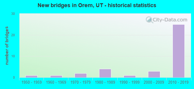
- New bridges - historical statistics
- 11950-1959
- 11960-1969
- 21970-1979
- 41980-1989
- 11990-1999
- 32000-2009
- 252010-2019
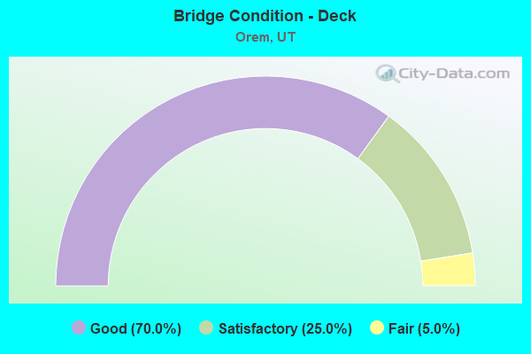
- Bridge Condition - Deck
- 70.0%Good
- 25.0%Satisfactory
- 5.0%Fair
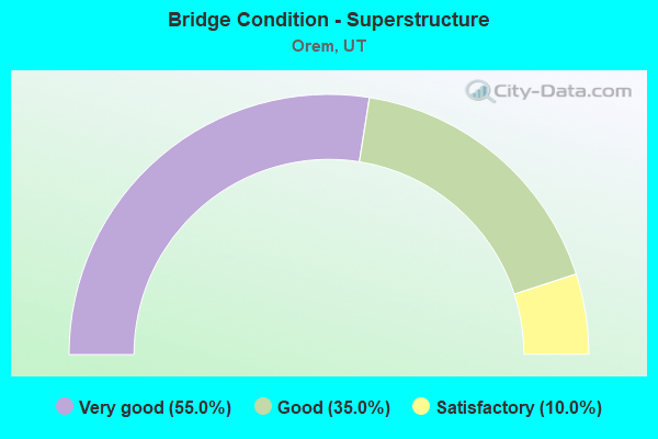
- Bridge Condition - Superstructure
- 55.0%Very good
- 35.0%Good
- 10.0%Satisfactory
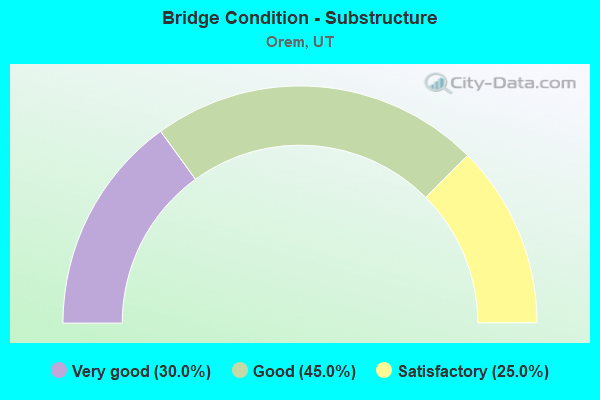
- Bridge Condition - Substructure
- 30.0%Very good
- 45.0%Good
- 25.0%Satisfactory
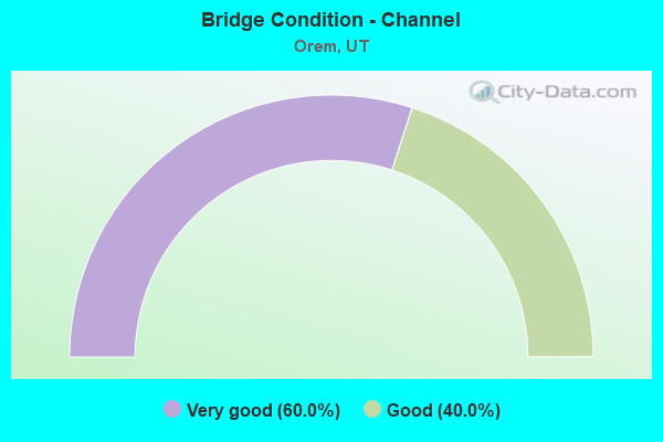
- Bridge Condition - Channel
- 60.0%Very good
- 40.0%Good
Find on map >> Show street view
Structure Number: 49025F, Location: 1080 EAST 800 SOUTH, OREM (Lat: 40.282514, Lng: -111.668797), Route carried "on" structure: City street 2974, Year Built: 1960, Year Reconstructed: 2000, Status: Open, Structure Length: 1.98m (6.50ft), Average Daily Traffic: 13,343 (year 2020), Average Future Daily Traffic: 16,679 (year 2040), Design Load: HS 20+Mod, Features Intersected: PROVO RIVER, Facility Carried by Structure: 800 SOUTH STREET
Minimum Vertical Clearance: 30+ m (98+ ft), Kilometerpoint: 4.689, Lanes on structure: 2, Owner: City or Municipal Highway Agency, Approaching Roadway Width: 16.2m (53.1ft), Skew: 20 degrees, Material/Design: Prestressed concrete, Design/Construction: Stringer/Multi-beam, Number Of Spans In Main Unit: 1, Length of Maximum Span: 18.6m (61.0ft), Curb or Sidewalk Widths: Left: 2.1m (6.9ft), Right: 2.1m (6.9ft), Curb-To-Curb Width: 16.2m (53.1ft), Out-to-Out Width: 21.3m (69.9ft)
Condition: Deck: Satisfactory, Superstructure: Good, Substructure: Satisfactory, Channel: Good, Operating Rating: 57.0 metric tons, Method Used To Determine Operating Rating: Load and Resistance Factor Rating (LRFR) rating reported by rating factor(RF) method using HL-93 loadings, Inventory Rating: 39.5 metric tons, Method Used To Determine Inventory Rating: Load Factor (LF) rating reported by rating factor (RF) method using MS18 loading, Structural Evaluation: Equal to present minimum criteria, Deck Geometry: Superior to present desirable criteria, Waterway Adequacy: Equal to present minimum criteria, Approach Roadway Alignment: Equal to present desirable criteria, Designated Inspection Frequency: Every 24 months, Inspection Date: September 2021, Deck Structure Type: Concrete Cast-file-Place, Wearing Surface/Protective System: Wearing Surface: Monolithic Concrete, Deck Protection: Epoxy Coated Reinforcing
Find on map >> Show street view
Structure Number: 49068F, Location: 1200 EAST CENTER ST. OREM (Lat: 40.297053, Lng: -111.666972), Route carried "on" structure: City street 2960, Year Built: 1982, Status: Open, Structure Length: 3.82m (12.53ft), Average Daily Traffic: 18,784 (year 2020), Average Future Daily Traffic: 23,480 (year 2040), Design Load: HS 20+Mod, Features Intersected: CARTERVILLE ROAD, Facility Carried by Structure: OREM CENTER STREET
Minimum Vertical Clearance: 30+ m (98+ ft), Kilometerpoint: 5.704, Lanes on structure: 4, Lanes under structure: 2, Owner: City or Municipal Highway Agency, Approaching Roadway Width: 16.0m (52.5ft), Skew: 2 degrees, Material/Design: Prestressed concrete, Design/Construction: Stringer/Multi-beam, Number Of Spans In Main Unit: 1, Length of Maximum Span: 36.5m (119.8ft), Curb or Sidewalk Widths: Left: 1.5m (4.9ft), Right: 1.5m (4.9ft), Curb-To-Curb Width: 16.0m (52.5ft), Out-to-Out Width: 21.4m (70.2ft)
Condition: Deck: Good, Superstructure: Satisfactory, Substructure: Good, Operating Rating: 56.1 metric tons, Method Used To Determine Operating Rating: Load and Resistance Factor Rating (LRFR) rating reported by rating factor(RF) method using HL-93 loadings, Inventory Rating: 35.0 metric tons, Method Used To Determine Inventory Rating: Load Factor (LF) rating reported by rating factor (RF) method using MS18 loading, Structural Evaluation: Equal to present minimum criteria, Deck Geometry: Meets minimum limits, Underclear: Equal to present minimum criteria, Approach Roadway Alignment: Equal to present desirable criteria, Designated Inspection Frequency: Every 24 months, Inspection Date: September 2021, Deck Structure Type: Concrete Cast-file-Place, Wearing Surface/Protective System: Wearing Surface: Monolithic Concrete, Deck Protection: Epoxy Coated Reinforcing
Find on map >> Show street view
Structure Number: 49084F, Location: NEAR MURDOCK DIVISION DAM (Lat: 40.326347, Lng: -111.642536), Route carried "on" structure: City street , Year Built: 1992, Status: Open, Structure Length: 2.05m (6.73ft), Average Daily Traffic: 242 (year 2020), Truck Traffic: 1%, Average Future Daily Traffic: 294 (year 2040), Design Load: HS 20+Mod, Features Intersected: PROVO RIVER, Facility Carried by Structure: OREM CITY ROAD
Minimum Vertical Clearance: 30+ m (98+ ft), Kilometerpoint: 0.014, Lanes on structure: 2, Owner: City or Municipal Highway Agency, Approaching Roadway Width: 9.3m (30.5ft), Material/Design: Prestressed concrete, Design/Construction: Stringer/Multi-beam, Number Of Spans In Main Unit: 1, Length of Maximum Span: 18.9m (62.0ft), Curb or Sidewalk Widths: Left: 1.4m (4.6ft), Right: 0.0m, Curb-To-Curb Width: 9.3m (30.5ft), Out-to-Out Width: 11.8m (38.7ft)
Condition: Deck: Good, Superstructure: Good, Substructure: Satisfactory, Channel: Very good, Operating Rating: 32.4 metric tons, Method Used To Determine Operating Rating: Load and Resistance Factor Rating (LRFR) rating reported by rating factor(RF) method using HL-93 loadings, Inventory Rating: 22.7 metric tons, Method Used To Determine Inventory Rating: Load Factor (LF) rating reported by rating factor (RF) method using MS18 loading, Structural Evaluation: Equal to present minimum criteria, Deck Geometry: Equal to present minimum criteria, Waterway Adequacy: Better than present minimum criteria, Approach Roadway Alignment: Equal to present desirable criteria, Designated Inspection Frequency: Every 24 months, Inspection Date: September 2021, Deck Structure Type: Concrete Cast-file-Place, Wearing Surface/Protective System: Wearing Surface: Monolithic Concrete, Deck Protection: Epoxy Coated Reinforcing
Find on map >> Show street view
Structure Number: 49104E, Location: 800 EAST 1400 NORTH, OREM (Lat: 40.322653, Lng: -111.676794), Route carried "on" structure: City street 2946, Year Built: 2012, Status: Open, Structure Length: 0.82m (2.69ft), Average Daily Traffic: 11,217 (year 2020), Average Future Daily Traffic: 14,021 (year 2040), Design Load: HL 93, Features Intersected: MURDOCK CANAL TRAIL, Facility Carried by Structure: 800 E. ST. IN OREM
Minimum Vertical Clearance: 30+ m (98+ ft), Kilometerpoint: 5.517, Lanes on structure: 2, Owner: City or Municipal Highway Agency, Approaching Roadway Width: 19.7m (64.6ft), Skew: 3 degrees, Material/Design: Concrete, Design/Construction: Culvert, Number Of Spans In Main Unit: 1, Length of Maximum Span: 7.2m (23.6ft), Curb or Sidewalk Widths: Left: 2.1m (6.9ft), Right: 2.1m (6.9ft)
Condition: Culverts: Good, Operating Rating: 32.4 metric tons, Method Used To Determine Operating Rating: Load and Resistance Factor Rating (LRFR) rating reported by rating factor(RF) method using HL-93 loadings, Inventory Rating: 18.1 metric tons, Method Used To Determine Inventory Rating: Load and Resistance Factor Rating (LRFR) rating reported by rating factor(RF) method using HL-93 loadings, Structural Evaluation: Meets minimum limits, Approach Roadway Alignment: Equal to present desirable criteria, Designated Inspection Frequency: Every 24 months, Inspection Date: October 2021
Find on map >> Show street view
Structure Number: C 568, Location: 750 EAST IN OREM (Lat: 40.265567, Lng: -111.671542), Route carried "on" structure: County highway 2962, Year Built: 1970, Status: Open, Structure Length: 7.80m (25.59ft), Average Daily Traffic: 8,875 (year 2020), Average Future Daily Traffic: 11,094 (year 2040), Design Load: HS 20+Mod, Features Intersected: SR-265, Facility Carried by Structure: CARTERVILLE ROAD
Minimum Vertical Clearance: 30+ m (98+ ft), Kilometerpoint: 0.982, Lanes on structure: 2, Lanes under structure: 8, Owner: State Highway Agency, Approaching Roadway Width: 9.1m (29.9ft), Skew: 4 degrees, Material/Design: Steel continuous, Design/Construction: Stringer/Multi-beam, Number Of Spans In Main Unit: 2, Length of Maximum Span: 39.3m (128.9ft), Curb or Sidewalk Widths: Left: 2.0m (6.6ft), Right: 2.0m (6.6ft), Curb-To-Curb Width: 9.8m (32.2ft), Out-to-Out Width: 13.7m (44.9ft)
Condition: Deck: Fair, Superstructure: Satisfactory, Substructure: Satisfactory, Operating Rating: 91.0 metric tons, Method Used To Determine Operating Rating: Load and Resistance Factor Rating (LRFR) rating reported by rating factor(RF) method using HL-93 loadings, Inventory Rating: 49.9 metric tons, Method Used To Determine Inventory Rating: Load Factor (LF) rating reported by rating factor (RF) method using MS18 loading, Structural Evaluation: Equal to present minimum criteria, Deck Geometry: Meets minimum limits, Underclear: Somewhat better than minimum adequacy, Approach Roadway Alignment: Equal to present desirable criteria, Designated Inspection Frequency: Every 24 months, Inspection Date: January 2021, Deck Structure Type: Concrete Cast-file-Place, Wearing Surface/Protective System: Wearing Surface: Monolithic Concrete
Find on map >> Show street view
Structure Number: C1015, Location: Near Geneva Plant Site (Lat: 40.291225, Lng: -111.734000), Route carried "on" structure: State highway 114, Year Built: 2012, Status: Open, Structure Length: 8.04m (26.38ft), Average Daily Traffic: 12,192 (year 2020), Truck Traffic: 25%, Average Future Daily Traffic: 15,240 (year 2040), Design Load: HL 93, Features Intersected: UPRR & UTA TRACKS
Minimum Vertical Clearance: 30+ m (98+ ft), Kilometerpoint: 10.015, Lanes on structure: 4, Owner: State Highway Agency, Approaching Roadway Width: 25.0m (82.0ft), Skew: 26 degrees, Material/Design: Steel, Design/Construction: Stringer/Multi-beam, Number Of Spans In Main Unit: 1, Length of Maximum Span: 77.6m (254.6ft), Curb or Sidewalk Widths: Left: 3.1m (10.2ft), Right: 1.8m (5.9ft), Curb-To-Curb Width: 25.0m (82.0ft), Out-to-Out Width: 31.5m (103.3ft)
Condition: Deck: Good, Superstructure: Very good, Substructure: Good, Operating Rating: 57.7 metric tons, Method Used To Determine Operating Rating: Load and Resistance Factor Rating (LRFR) rating reported by rating factor(RF) method using HL-93 loadings, Inventory Rating: 34.3 metric tons, Method Used To Determine Inventory Rating: Load and Resistance Factor Rating (LRFR) rating reported by rating factor(RF) method using HL-93 loadings, Structural Evaluation: Better than present minimum criteria, Deck Geometry: Superior to present desirable criteria, Underclear: Equal to present minimum criteria, Approach Roadway Alignment: Equal to present desirable criteria, Designated Inspection Frequency: Every 24 months, Inspection Date: January 2021, Deck Structure Type: Concrete Cast-file-Place, Wearing Surface/Protective System: Wearing Surface: Epoxy Overlay, Membrane: Epoxy, Deck Protection: Epoxy Coated Reinforcing
Find on map >> Show street view
Structure Number: E2222, Location: 1.1 MI.EAST OF OLMSTEAD (Lat: 40.324042, Lng: -111.643167), Route carried "on" structure: State highway 189, Year Built: 1956, Status: Open, Structure Length: 1.12m (3.67ft), Average Daily Traffic: 27,989 (year 2020), Truck Traffic: 33%, Average Future Daily Traffic: 34,986 (year 2040), Design Load: H 15, Features Intersected: MURDOCK CANAL
Minimum Vertical Clearance: 30+ m (98+ ft), Kilometerpoint: 13.633, Lanes on structure: 4, Base Highway Network: Yes, Owner: State Highway Agency, Approaching Roadway Width: 25.6m (84.0ft), Skew: 6 degrees, Material/Design: Concrete, Design/Construction: Culvert, Number Of Spans In Main Unit: 1, Length of Maximum Span: 9.4m (30.8ft)
Condition: Channel: Very good, Culverts: Good, Operating Rating: 36.0 metric tons, Method Used To Determine Operating Rating: Load Factor (LF) rating reported by rating factor (RF) method using MS18 loading, Inventory Rating: 21.4 metric tons, Method Used To Determine Inventory Rating: Load Factor (LF) rating reported by rating factor (RF) method using MS18 loading, Structural Evaluation: Somewhat better than minimum adequacy, Waterway Adequacy: Equal to present desirable criteria, Approach Roadway Alignment: Equal to present desirable criteria, Designated Inspection Frequency: Every 24 months, Inspection Date: May 2021
Find on map >> Show street view
Structure Number: F 673, Location: 1200 SO. INTCHG. in OREM (Lat: 40.275292, Lng: -111.719386), Route carried "on" structure: State highway 265, Year Built: 2001, Status: Open, Structure Length: 6.59m (21.62ft), Average Daily Traffic: 21,837 (year 2020), Truck Traffic: 23%, Average Future Daily Traffic: 27,296 (year 2040), Design Load: HS 20+Mod, Features Intersected: I-15 (SR-15) NBL AND SBL
Minimum Vertical Clearance: 5.07m (16.63ft), Kilometerpoint: 0.672, Lanes on structure: 6, Lanes under structure: 10, Base Highway Network: Yes, Owner: State Highway Agency, Approaching Roadway Width: 31.2m (102.4ft), Skew: 3 degrees, Material/Design: Prestressed concrete continuous, Design/Construction: Stringer/Multi-beam, Number Of Spans In Main Unit: 2, Length of Maximum Span: 32.6m (107.0ft), Curb or Sidewalk Widths: Left: 3.1m (10.2ft), Right: 0.0m, Curb-To-Curb Width: 32.0m (105.0ft), Out-to-Out Width: 71.0m (232.9ft)
Condition: Deck: Satisfactory, Superstructure: Good, Substructure: Good, Operating Rating: 44.7 metric tons, Method Used To Determine Operating Rating: Load and Resistance Factor Rating (LRFR) rating reported by rating factor(RF) method using HL-93 loadings, Inventory Rating: 36.0 metric tons, Method Used To Determine Inventory Rating: Load Factor (LF) rating reported by rating factor (RF) method using MS18 loading, Structural Evaluation: Better than present minimum criteria, Deck Geometry: Superior to present desirable criteria, Underclear: Equal to present minimum criteria, Approach Roadway Alignment: Equal to present desirable criteria, Designated Inspection Frequency: Every 24 months, Inspection Date: December 2020, Deck Structure Type: Concrete Cast-file-Place, Wearing Surface/Protective System: Wearing Surface: Epoxy Overlay, Deck Protection: Epoxy Coated Reinforcing
Find on map >> Show street view
Structure Number: F 674, Location: WEST of 12th SO.INT.,OREM (Lat: 40.275242, Lng: -111.721956), Route carried "on" structure: State highway 265, Year Built: 2001, Status: Open, Structure Length: 8.29m (27.20ft), Average Daily Traffic: 21,837 (year 2020), Truck Traffic: 23%, Average Future Daily Traffic: 27,296 (year 2040), Design Load: HS 20+Mod, Features Intersected: UPRR and UTA
Minimum Vertical Clearance: 30.18m (99.02ft), Kilometerpoint: 0.453, Lanes on structure: 5, Owner: State Highway Agency, Approaching Roadway Width: 31.2m (102.4ft), Skew: 32 degrees, Material/Design: Prestressed concrete continuous, Design/Construction: Stringer/Multi-beam, Number Of Spans In Main Unit: 2, Length of Maximum Span: 41.0m (134.5ft), Curb or Sidewalk Widths: Left: 2.0m (6.6ft), Right: 0.0m, Curb-To-Curb Width: 31.5m (103.3ft), Out-to-Out Width: 35.6m (116.8ft)
Condition: Deck: Good, Superstructure: Very good, Substructure: Good, Operating Rating: 40.8 metric tons, Method Used To Determine Operating Rating: Load and Resistance Factor Rating (LRFR) rating reported by rating factor(RF) method using HL-93 loadings, Inventory Rating: 32.4 metric tons, Method Used To Determine Inventory Rating: Load Factor (LF) rating reported by rating factor (RF) method using MS18 loading, Structural Evaluation: Better than present minimum criteria, Deck Geometry: Superior to present desirable criteria, Underclear: Equal to present desirable criteria, Approach Roadway Alignment: Equal to present desirable criteria, Designated Inspection Frequency: Every 24 months, Inspection Date: January 2021, Deck Structure Type: Concrete Cast-file-Place, Wearing Surface/Protective System: Wearing Surface: Epoxy Overlay, Deck Protection: Epoxy Coated Reinforcing
Find on map >> Show street view
Structure Number: 1C 99, Location: OREM CENTER ST INTERCHANG (Lat: 40.296833, Lng: -111.725533), Route carried "on" structure: Interstate 15, Year Built: 2011, Status: Open, Structure Length: 6.66m (21.85ft), Average Daily Traffic: 154,070 (year 2020), Truck Traffic: 20%, Average Future Daily Traffic: 192,588 (year 2040), Design Load: HL 93, Features Intersected: Center Street in Orem
Minimum Vertical Clearance: 30+ m (98+ ft), Kilometerpoint: 436.104, Lanes on structure: 6, Lanes under structure: 7, Base Highway Network: Yes, Owner: State Highway Agency, Approaching Roadway Width: 28.0m (91.9ft), Skew: 10 degrees, Material/Design: Steel, Design/Construction: Stringer/Multi-beam, Number Of Spans In Main Unit: 1, Length of Maximum Span: 65.7m (215.6ft), Curb-To-Curb Width: 28.0m (91.9ft), Out-to-Out Width: 30.7m (100.7ft)
Condition: Deck: Good, Superstructure: Very good, Substructure: Good, Operating Rating: 41.8 metric tons, Method Used To Determine Operating Rating: Load and Resistance Factor Rating (LRFR) rating reported by rating factor(RF) method using HL-93 loadings, Inventory Rating: 27.5 metric tons, Method Used To Determine Inventory Rating: Load and Resistance Factor Rating (LRFR) rating reported by rating factor(RF) method using HL-93 loadings, Structural Evaluation: Equal to present minimum criteria, Deck Geometry: Equal to present minimum criteria, Underclear: Superior to present desirable criteria, Approach Roadway Alignment: Equal to present minimum criteria, Designated Inspection Frequency: Every 24 months, Inspection Date: January 2021, Deck Structure Type: Concrete Precast Panels, Wearing Surface/Protective System: Wearing Surface: Epoxy Overlay, Deck Protection: Epoxy Coated Reinforcing
Find on map >> Show street view
Structure Number: 1C 991, Location: AT 800 NO.in OREM INTCHG. (Lat: 40.311461, Lng: -111.725825), Route carried "on" structure: Interstate 15, Year Built: 2011, Status: Open, Structure Length: 6.66m (21.85ft), Average Daily Traffic: 154,070 (year 2020), Truck Traffic: 20%, Average Future Daily Traffic: 192,588 (year 2040), Design Load: HL 93, Features Intersected: SR-52, INTCHG. X-ROAD
Minimum Vertical Clearance: 30+ m (98+ ft), Kilometerpoint: 437.728, Lanes on structure: 6, Lanes under structure: 8, Base Highway Network: Yes, Owner: State Highway Agency, Approaching Roadway Width: 29.9m (98.1ft), Skew: 10 degrees, Material/Design: Steel, Design/Construction: Stringer/Multi-beam, Number Of Spans In Main Unit: 1, Length of Maximum Span: 65.7m (215.6ft), Curb-To-Curb Width: 29.9m (98.1ft), Out-to-Out Width: 30.7m (100.7ft)
Condition: Deck: Good, Superstructure: Very good, Substructure: Very good, Operating Rating: 41.8 metric tons, Method Used To Determine Operating Rating: Load and Resistance Factor Rating (LRFR) rating reported by rating factor(RF) method using HL-93 loadings, Inventory Rating: 27.5 metric tons, Method Used To Determine Inventory Rating: Load and Resistance Factor Rating (LRFR) rating reported by rating factor(RF) method using HL-93 loadings, Structural Evaluation: Equal to present minimum criteria, Deck Geometry: Superior to present desirable criteria, Underclear: Better than present minimum criteria, Approach Roadway Alignment: Equal to present desirable criteria, Designated Inspection Frequency: Every 24 months, Inspection Date: January 2021, Deck Structure Type: Concrete Cast-file-Place, Wearing Surface/Protective System: Wearing Surface: Epoxy Overlay, Deck Protection: Epoxy Coated Reinforcing
Find on map >> Show street view
Structure Number: 1C 994, Location: PROVO CENTER ST. INTCHG. (Lat: 40.233775, Lng: -111.684556), Route carried "on" structure: Interstate 15, Year Built: 2011, Status: Open, Structure Length: 8.39m (27.53ft), Average Daily Traffic: 126,866 (year 2020), Truck Traffic: 23%, Average Future Daily Traffic: 158,583 (year 2040), Design Load: HL 93, Features Intersected: PROVO CENTER STREET
Minimum Vertical Clearance: 30+ m (98+ ft), Kilometerpoint: 427.999, Lanes on structure: 5, Lanes under structure: 7, Base Highway Network: Yes, Owner: State Highway Agency, Approaching Roadway Width: 26.1m (85.6ft), Material/Design: Steel continuous, Design/Construction: Stringer/Multi-beam, Number Of Spans In Main Unit: 2, Length of Maximum Span: 43.1m (141.4ft), Curb-To-Curb Width: 26.1m (85.6ft), Out-to-Out Width: 26.9m (88.3ft)
Condition: Deck: Good, Superstructure: Very good, Substructure: Very good, Operating Rating: 38.9 metric tons, Method Used To Determine Operating Rating: Load and Resistance Factor Rating (LRFR) rating reported by rating factor(RF) method using HL-93 loadings, Inventory Rating: 27.2 metric tons, Method Used To Determine Inventory Rating: Load and Resistance Factor Rating (LRFR) rating reported by rating factor(RF) method using HL-93 loadings, Structural Evaluation: Equal to present minimum criteria, Deck Geometry: Superior to present desirable criteria, Underclear: Equal to present minimum criteria, Approach Roadway Alignment: Equal to present desirable criteria, Designated Inspection Frequency: Every 24 months, Inspection Date: January 2021, Deck Structure Type: Concrete Precast Panels, Wearing Surface/Protective System: Wearing Surface: Epoxy Overlay, Deck Protection: Epoxy Coated Reinforcing
Find on map >> Show street view
Structure Number: 1F 814, Location: At 1600 NORTH INTERCHANGE (Lat: 40.326100, Lng: -111.731531), Route carried "on" structure: Interstate 15, Year Built: 2011, Status: Open, Structure Length: 6.19m (20.31ft), Average Daily Traffic: 200,425 (year 2020), Truck Traffic: 19%, Average Future Daily Traffic: 250,531 (year 2040), Design Load: HL 93, Features Intersected: 1600 NO.ST.,INT.X-RD.
Minimum Vertical Clearance: 30+ m (98+ ft), Kilometerpoint: 439.512, Lanes on structure: 6, Lanes under structure: 6, Base Highway Network: Yes, Owner: State Highway Agency, Approaching Roadway Width: 29.9m (98.1ft), Skew: 34 degrees, Material/Design: Prestressed concrete continuous, Design/Construction: Stringer/Multi-beam, Number Of Spans In Main Unit: 2, Length of Maximum Span: 30.0m (98.4ft), Curb-To-Curb Width: 29.9m (98.1ft), Out-to-Out Width: 30.7m (100.7ft)
Condition: Deck: Good, Superstructure: Good, Substructure: Good, Operating Rating: 56.4 metric tons, Method Used To Determine Operating Rating: Load and Resistance Factor Rating (LRFR) rating reported by rating factor(RF) method using HL-93 loadings, Inventory Rating: 35.3 metric tons, Method Used To Determine Inventory Rating: Load and Resistance Factor Rating (LRFR) rating reported by rating factor(RF) method using HL-93 loadings, Structural Evaluation: Better than present minimum criteria, Deck Geometry: Superior to present desirable criteria, Underclear: Meets minimum limits, Approach Roadway Alignment: Equal to present desirable criteria, Designated Inspection Frequency: Every 24 months, Inspection Date: January 2021, Deck Structure Type: Concrete Precast Panels, Wearing Surface/Protective System: Wearing Surface: Epoxy Overlay, Deck Protection: Epoxy Coated Reinforcing
Find on map >> Show street view
Structure Number: 1F 818, Location: I-15 & 400 North in O (Lat: 40.304294, Lng: -111.725664), Route carried "on" structure: Interstate 15, Year Built: 2011, Status: Open, Structure Length: 3.23m (10.60ft), Average Daily Traffic: 154,070 (year 2020), Truck Traffic: 20%, Average Future Daily Traffic: 192,588 (year 2040), Design Load: HL 93, Features Intersected: 400 North Street
Minimum Vertical Clearance: 30+ m (98+ ft), Kilometerpoint: 436.932, Lanes on structure: 7, Lanes under structure: 2, Base Highway Network: Yes, Owner: State Highway Agency, Approaching Roadway Width: 31.7m (104.0ft), Skew: 20 degrees, Material/Design: Prestressed concrete, Design/Construction: Stringer/Multi-beam, Number Of Spans In Main Unit: 1, Length of Maximum Span: 31.4m (103.0ft), Curb-To-Curb Width: 31.7m (104.0ft), Out-to-Out Width: 34.3m (112.5ft)
Condition: Deck: Good, Superstructure: Good, Substructure: Very good, Operating Rating: 55.4 metric tons, Method Used To Determine Operating Rating: Load and Resistance Factor Rating (LRFR) rating reported by rating factor(RF) method using HL-93 loadings, Inventory Rating: 36.0 metric tons, Method Used To Determine Inventory Rating: Load and Resistance Factor Rating (LRFR) rating reported by rating factor(RF) method using HL-93 loadings, Structural Evaluation: Better than present minimum criteria, Deck Geometry: Equal to present minimum criteria, Underclear: Meets minimum limits, Approach Roadway Alignment: Equal to present minimum criteria, Designated Inspection Frequency: Every 24 months, Inspection Date: January 2021, Deck Structure Type: Concrete Precast Panels, Wearing Surface/Protective System: Wearing Surface: Epoxy Overlay, Deck Protection: Epoxy Coated Reinforcing
Find on map >> Show street view
Structure Number: 1F 826, Location: 450 WEST 2000 SO. OREM (Lat: 40.260567, Lng: -111.705250), Route carried "on" structure: Interstate 15, Year Built: 2011, Status: Open, Structure Length: 4.39m (14.40ft), Average Daily Traffic: 139,790 (year 2020), Truck Traffic: 22%, Average Future Daily Traffic: 174,738 (year 2040), Design Load: HL 93, Features Intersected: 2000 SOUTH ST. in OREM
Minimum Vertical Clearance: 30+ m (98+ ft), Kilometerpoint: 431.566, Lanes on structure: 5, Lanes under structure: 4, Base Highway Network: Yes, Owner: State Highway Agency, Approaching Roadway Width: 26.1m (85.6ft), Skew: 4 degrees, Material/Design: Prestressed concrete, Design/Construction: Stringer/Multi-beam, Number Of Spans In Main Unit: 1, Length of Maximum Span: 42.2m (138.5ft), Curb-To-Curb Width: 26.1m (85.6ft), Out-to-Out Width: 26.9m (88.3ft)
Condition: Deck: Good, Superstructure: Very good, Substructure: Very good, Operating Rating: 55.4 metric tons, Method Used To Determine Operating Rating: Load and Resistance Factor Rating (LRFR) rating reported by rating factor(RF) method using HL-93 loadings, Inventory Rating: 35.3 metric tons, Method Used To Determine Inventory Rating: Load and Resistance Factor Rating (LRFR) rating reported by rating factor(RF) method using HL-93 loadings, Structural Evaluation: Equal to present desirable criteria, Deck Geometry: Superior to present desirable criteria, Underclear: Superior to present desirable criteria, Approach Roadway Alignment: Equal to present desirable criteria, Designated Inspection Frequency: Every 24 months, Inspection Date: January 2021, Deck Structure Type: Concrete Precast Panels, Wearing Surface/Protective System: Wearing Surface: Epoxy Overlay, Deck Protection: Epoxy Coated Reinforcing
Find on map >> Show street view
Structure Number: 2F 488, Location: AT OLMSTEAD INTCHG. (Lat: 40.313250, Lng: -111.656511), Route carried "on" structure: State highway 52, Year Built: 1985, Status: Open, Structure Length: 3.88m (12.73ft), Average Daily Traffic: 6,503 (year 2020), Truck Traffic: 20%, Average Future Daily Traffic: 8,129 (year 2040), Design Load: HS 20+Mod, Features Intersected: PROVO RIVER
Minimum Vertical Clearance: 30+ m (98+ ft), Kilometerpoint: 0.102, Lanes on structure: 2, Base Highway Network: Yes (Inventory Route: 52NR0, Subroute: 4), Owner: State Highway Agency, Approaching Roadway Width: 11.5m (37.7ft), Skew: 1 degrees, Material/Design: Prestressed concrete, Design/Construction: Stringer/Multi-beam, Number Of Spans In Main Unit: 1, Length of Maximum Span: 29.1m (95.5ft), Curb-To-Curb Width: 11.5m (37.7ft), Out-to-Out Width: 12.7m (41.7ft)
Condition: Deck: Satisfactory, Superstructure: Good, Substructure: Satisfactory, Channel: Good, Operating Rating: 53.1 metric tons, Method Used To Determine Operating Rating: Load and Resistance Factor Rating (LRFR) rating reported by rating factor(RF) method using HL-93 loadings, Inventory Rating: 43.1 metric tons, Method Used To Determine Inventory Rating: Load Factor (LF) rating reported by rating factor (RF) method using MS18 loading, Structural Evaluation: Equal to present minimum criteria, Deck Geometry: Equal to present minimum criteria, Waterway Adequacy: Equal to present desirable criteria, Approach Roadway Alignment: Equal to present minimum criteria, Designated Inspection Frequency: Every 24 months, Inspection Date: May 2021, Deck Structure Type: Concrete Cast-file-Place, Wearing Surface/Protective System: Wearing Surface: Monolithic Concrete, Deck Protection: Epoxy Coated Reinforcing
Find on map >> Show street view
Structure Number: 3C 99, Location: Orem Center St Interchang (Lat: 40.297572, Lng: -111.725944), Route carried "on" structure: Interstate 15, Year Built: 2011, Status: Open, Structure Length: 6.66m (21.85ft), Average Daily Traffic: 181,257 (year 2020), Truck Traffic: 21%, Average Future Daily Traffic: 226,571 (year 2040), Design Load: HL 93, Features Intersected: Center Street in Orem
Minimum Vertical Clearance: 30.45m (99.90ft), Kilometerpoint: 435.994, Lanes on structure: 6, Lanes under structure: 7, Base Highway Network: Yes, Owner: State Highway Agency, Approaching Roadway Width: 28.0m (91.9ft), Skew: 10 degrees, Material/Design: Steel, Design/Construction: Stringer/Multi-beam, Number Of Spans In Main Unit: 1, Length of Maximum Span: 65.7m (215.6ft), Curb-To-Curb Width: 28.0m (91.9ft), Out-to-Out Width: 30.7m (100.7ft)
Condition: Deck: Good, Superstructure: Very good, Substructure: Very good, Operating Rating: 41.8 metric tons, Method Used To Determine Operating Rating: Load and Resistance Factor Rating (LRFR) rating reported by rating factor(RF) method using HL-93 loadings, Inventory Rating: 27.5 metric tons, Method Used To Determine Inventory Rating: Load and Resistance Factor Rating (LRFR) rating reported by rating factor(RF) method using HL-93 loadings, Structural Evaluation: Equal to present minimum criteria, Deck Geometry: Equal to present minimum criteria, Underclear: Superior to present desirable criteria, Approach Roadway Alignment: Equal to present minimum criteria, Designated Inspection Frequency: Every 24 months, Inspection Date: January 2021, Deck Structure Type: Concrete Cast-file-Place, Wearing Surface/Protective System: Wearing Surface: Epoxy Overlay, Deck Protection: Epoxy Coated Reinforcing
Find on map >> Show street view
Structure Number: 3C 991, Location: At the 800 North Intchg. (Lat: 40.312203, Lng: -111.726167), Route carried "on" structure: Interstate 15, Year Built: 2011, Status: Open, Structure Length: 6.66m (21.85ft), Average Daily Traffic: 154,070 (year 2020), Truck Traffic: 20%, Average Future Daily Traffic: 192,588 (year 2040), Design Load: HL 93, Features Intersected: SR-52, INTCHG. X-ROAD.
Minimum Vertical Clearance: 30+ m (98+ ft), Kilometerpoint: 437.618, Lanes on structure: 6, Lanes under structure: 8, Base Highway Network: Yes, Owner: State Highway Agency, Approaching Roadway Width: 29.9m (98.1ft), Skew: 30 degrees, Material/Design: Steel, Design/Construction: Stringer/Multi-beam, Number Of Spans In Main Unit: 1, Length of Maximum Span: 65.7m (215.6ft), Curb-To-Curb Width: 29.9m (98.1ft), Out-to-Out Width: 30.7m (100.7ft)
Condition: Deck: Good, Superstructure: Very good, Substructure: Very good, Operating Rating: 41.8 metric tons, Method Used To Determine Operating Rating: Load and Resistance Factor Rating (LRFR) rating reported by rating factor(RF) method using HL-93 loadings, Inventory Rating: 27.5 metric tons, Method Used To Determine Inventory Rating: Load and Resistance Factor Rating (LRFR) rating reported by rating factor(RF) method using HL-93 loadings, Structural Evaluation: Equal to present minimum criteria, Deck Geometry: Superior to present desirable criteria, Underclear: Better than present minimum criteria, Approach Roadway Alignment: Equal to present desirable criteria, Designated Inspection Frequency: Every 24 months, Inspection Date: January 2021, Deck Structure Type: Concrete Cast-file-Place, Wearing Surface/Protective System: Wearing Surface: Epoxy Overlay, Deck Protection: Epoxy Coated Reinforcing
Find on map >> Show street view
Structure Number: 3F 815, Location: 800 West 400 South-Orem (Lat: 40.290108, Lng: -111.725781), Route carried "on" structure: Interstate 15, Year Built: 2012, Status: Open, Structure Length: 3.23m (10.60ft), Average Daily Traffic: 181,257 (year 2020), Truck Traffic: 21%, Average Future Daily Traffic: 226,571 (year 2040), Design Load: HL 93, Features Intersected: 400 SOUTH ST.in OREM
Minimum Vertical Clearance: 30.45m (99.90ft), Kilometerpoint: 435.165, Lanes on structure: 7, Lanes under structure: 4, Base Highway Network: Yes, Owner: State Highway Agency, Approaching Roadway Width: 33.4m (109.6ft), Material/Design: Prestressed concrete, Design/Construction: Stringer/Multi-beam, Number Of Spans In Main Unit: 1, Length of Maximum Span: 31.4m (103.0ft), Curb-To-Curb Width: 33.4m (109.6ft), Out-to-Out Width: 34.2m (112.2ft)
Condition: Deck: Good, Superstructure: Very good, Substructure: Good, Operating Rating: 56.1 metric tons, Method Used To Determine Operating Rating: Load and Resistance Factor Rating (LRFR) rating reported by rating factor(RF) method using HL-93 loadings, Inventory Rating: 36.3 metric tons, Method Used To Determine Inventory Rating: Load and Resistance Factor Rating (LRFR) rating reported by rating factor(RF) method using HL-93 loadings, Structural Evaluation: Better than present minimum criteria, Deck Geometry: Superior to present desirable criteria, Underclear: Equal to present minimum criteria, Approach Roadway Alignment: Equal to present desirable criteria, Designated Inspection Frequency: Every 24 months, Inspection Date: January 2021, Deck Structure Type: Concrete Cast-file-Place, Wearing Surface/Protective System: Wearing Surface: Epoxy Overlay, Deck Protection: Epoxy Coated Reinforcing
Find on map >> Show street view
Structure Number: 3F 818, Location: I-15 & 400 North in O (Lat: 40.304719, Lng: -111.726036), Route carried "on" structure: Interstate 15, Year Built: 2011, Status: Open, Structure Length: 3.23m (10.60ft), Average Daily Traffic: 154,070 (year 2020), Truck Traffic: 20%, Average Future Daily Traffic: 192,588 (year 2040), Design Load: HL 93, Features Intersected: 400 North Street
Minimum Vertical Clearance: 30+ m (98+ ft), Kilometerpoint: 436.787, Lanes on structure: 7, Lanes under structure: 2, Base Highway Network: Yes, Owner: State Highway Agency, Approaching Roadway Width: 31.7m (104.0ft), Skew: 10 degrees, Material/Design: Prestressed concrete, Design/Construction: Stringer/Multi-beam, Number Of Spans In Main Unit: 1, Length of Maximum Span: 31.4m (103.0ft), Curb-To-Curb Width: 31.7m (104.0ft), Out-to-Out Width: 34.3m (112.5ft)
Condition: Deck: Good, Superstructure: Very good, Substructure: Good, Operating Rating: 56.1 metric tons, Method Used To Determine Operating Rating: Load and Resistance Factor Rating (LRFR) rating reported by rating factor(RF) method using HL-93 loadings, Inventory Rating: 36.3 metric tons, Method Used To Determine Inventory Rating: Load and Resistance Factor Rating (LRFR) rating reported by rating factor(RF) method using HL-93 loadings, Structural Evaluation: Better than present minimum criteria, Deck Geometry: Equal to present minimum criteria, Underclear: Meets minimum limits, Approach Roadway Alignment: Equal to present minimum criteria, Designated Inspection Frequency: Every 24 months, Inspection Date: January 2021, Deck Structure Type: Concrete Precast Panels, Wearing Surface/Protective System: Wearing Surface: Epoxy Overlay, Deck Protection: Epoxy Coated Reinforcing
Find on map >> Show street view
Structure Number: 3F 826, Location: 450 WEST 2000 SO.in OREM (Lat: 40.260969, Lng: -111.706103), Route carried "on" structure: Interstate 15, Year Built: 2011, Status: Open, Structure Length: 4.39m (14.40ft), Average Daily Traffic: 139,790 (year 2020), Truck Traffic: 22%, Average Future Daily Traffic: 174,738 (year 2040), Design Load: HL 93, Features Intersected: 2000 SOUTH ST. in OREM
Minimum Vertical Clearance: 30+ m (98+ ft), Kilometerpoint: 431.432, Lanes on structure: 6, Lanes under structure: 4, Base Highway Network: Yes, Owner: State Highway Agency, Approaching Roadway Width: 29.7m (97.4ft), Skew: 4 degrees, Material/Design: Prestressed concrete, Design/Construction: Stringer/Multi-beam, Number Of Spans In Main Unit: 1, Length of Maximum Span: 42.2m (138.5ft), Curb-To-Curb Width: 29.7m (97.4ft), Out-to-Out Width: 30.6m (100.4ft)
Condition: Deck: Satisfactory, Superstructure: Very good, Substructure: Good, Operating Rating: 56.7 metric tons, Method Used To Determine Operating Rating: Load and Resistance Factor Rating (LRFR) rating reported by rating factor(RF) method using HL-93 loadings, Inventory Rating: 36.6 metric tons, Method Used To Determine Inventory Rating: Load and Resistance Factor Rating (LRFR) rating reported by rating factor(RF) method using HL-93 loadings, Structural Evaluation: Better than present minimum criteria, Deck Geometry: Superior to present desirable criteria, Underclear: Superior to present desirable criteria, Approach Roadway Alignment: Equal to present desirable criteria, Designated Inspection Frequency: Every 24 months, Inspection Date: January 2021, Deck Structure Type: Concrete Cast-file-Place, Wearing Surface/Protective System: Wearing Surface: Epoxy Overlay, Deck Protection: Epoxy Coated Reinforcing
Find on map >> Show street view
Structure Number: 4F 487, Location: AT OLMSTED (Lat: 40.313189, Lng: -111.656942), Route carried "on" structure: State highway 52, Year Built: 1984, Status: Open, Structure Length: 2.96m (9.71ft), Average Daily Traffic: 6,503 (year 2020), Truck Traffic: 20%, Average Future Daily Traffic: 8,129 (year 2040), Design Load: HS 20+Mod, Features Intersected: PROVO RIVER
Minimum Vertical Clearance: 30+ m (98+ ft), Kilometerpoint: 0.017, Lanes on structure: 2, Base Highway Network: Yes (Inventory Route: 52PR0, Subroute: 1), Owner: State Highway Agency, Approaching Roadway Width: 12.0m (39.4ft), Skew: 2 degrees, Material/Design: Prestressed concrete, Design/Construction: Stringer/Multi-beam, Number Of Spans In Main Unit: 1, Length of Maximum Span: 28.8m (94.5ft), Curb-To-Curb Width: 12.0m (39.4ft), Out-to-Out Width: 13.0m (42.7ft)
Condition: Deck: Satisfactory, Superstructure: Good, Substructure: Satisfactory, Channel: Very good, Operating Rating: 50.2 metric tons, Method Used To Determine Operating Rating: Load and Resistance Factor Rating (LRFR) rating reported by rating factor(RF) method using HL-93 loadings, Inventory Rating: 41.8 metric tons, Method Used To Determine Inventory Rating: Load Factor (LF) rating reported by rating factor (RF) method using MS18 loading, Structural Evaluation: Equal to present minimum criteria, Deck Geometry: Better than present minimum criteria, Waterway Adequacy: Equal to present desirable criteria, Approach Roadway Alignment: Equal to present minimum criteria, Designated Inspection Frequency: Every 24 months, Inspection Date: May 2021, Deck Structure Type: Concrete Cast-file-Place, Wearing Surface/Protective System: Wearing Surface: Monolithic Concrete, Deck Protection: Epoxy Coated Reinforcing
Find on map >> Show street view
Structure Number: 49068F, Location: 1200 EAST CENTER ST. OREM (Lat: 40.297053, Lng: -111.666972), Route carried "under" structure: City street 2960, Year Built: 1982, Structure Length: 0. m, Average Daily Traffic: 18,784 (year 2020), Features Intersected: CARTERVILLE ROAD, Facility Carried by Structure: OREM CENTER STREET
Minimum Vertical Clearance: 5.08m (16.67ft), Kilometerpoint: 5.704, Lanes on structure: 4, Lanes under structure: 2, Material/Design: Prestressed concrete, Design/Construction: Stringer/Multi-beam, Length of Maximum Span: 36.5m (119.8ft)
Find on map >> Show street view
Structure Number: C 568, Location: 750 EAST IN OREM (Lat: 40.265567, Lng: -111.671542), Route carried "under" structure: State highway 265, Year Built: 1970, Structure Length: 0. m, Average Daily Traffic: 30,066 (year 2020), Truck Traffic: 23%, Features Intersected: SR-265, Facility Carried by Structure: CARTERVILLE ROAD
Minimum Vertical Clearance: 4.95m (16.24ft), Kilometerpoint: 5.398, Lanes on structure: 2, Lanes under structure: 8, Material/Design: Steel continuous, Design/Construction: Stringer/Multi-beam, Length of Maximum Span: 39.3m (128.9ft)
Find on map >> Show street view
Structure Number: F 673, Location: 1200 SO. INTCHG. in OREM (Lat: 40.275292, Lng: -111.719386), Route carried "under" structure: Interstate 15, Year Built: 2001, Structure Length: 0. m, Average Daily Traffic: 139,790 (year 2020), Truck Traffic: 22%, Features Intersected: I-15 (SR-15) NBL AND SBL, Facility Carried by Structure: SR-265, INT.X-RD.
Minimum Vertical Clearance: 5.07m (16.63ft), Kilometerpoint: 432.724, Lanes on structure: 6, Lanes under structure: 10, Material/Design: Prestressed concrete continuous, Design/Construction: Stringer/Multi-beam, Length of Maximum Span: 32.6m (107.0ft)
Find on map >> Show street view
Structure Number: 1C 99, Location: OREM CENTER ST INTERCHANG (Lat: 40.296833, Lng: -111.725533), Route carried "under" structure: City street 2960, Year Built: 2011, Structure Length: 0. m, Average Daily Traffic: 9,432 (year 2020), Features Intersected: Center Street in Orem, Facility Carried by Structure: I-15 (SR-15) NBL
Minimum Vertical Clearance: 5.11m (16.77ft), Kilometerpoint: 0.000, Lanes on structure: 6, Lanes under structure: 7, Material/Design: Steel, Design/Construction: Stringer/Multi-beam, Length of Maximum Span: 65.7m (215.6ft)
Find on map >> Show street view
Structure Number: 1C 991, Location: AT 800 NO.in OREM INTCHG. (Lat: 40.311461, Lng: -111.725825), Route carried "under" structure: State highway 52, Year Built: 2011, Structure Length: 0. m, Average Daily Traffic: 6,503 (year 2020), Truck Traffic: 20%, Features Intersected: SR-52, INTCHG. X-ROAD, Facility Carried by Structure: I-15 (SR-15) NB
Minimum Vertical Clearance: 5.26m (17.26ft), Kilometerpoint: 0.747, Lanes on structure: 6, Lanes under structure: 8, Material/Design: Steel, Design/Construction: Stringer/Multi-beam, Length of Maximum Span: 65.7m (215.6ft)
Find on map >> Show street view
Structure Number: 1C 994, Location: PROVO CENTER ST. INTCHG. (Lat: 40.233775, Lng: -111.684556), Route carried "under" structure: Interstate 114, Year Built: 2011, Structure Length: 0. m, Average Daily Traffic: 30,483 (year 2020), Truck Traffic: 15%, Features Intersected: PROVO CENTER STREET, Facility Carried by Structure: I-15NB, (SR-15)
Minimum Vertical Clearance: 5.05m (16.57ft), Kilometerpoint: 0.000, Lanes on structure: 5, Lanes under structure: 5, Material/Design: Steel continuous, Design/Construction: Stringer/Multi-beam, Length of Maximum Span: 43.1m (141.4ft)
Find on map >> Show street view
Structure Number: 1F 814, Location: At 1600 NORTH INTERCHANGE (Lat: 40.326100, Lng: -111.731531), Route carried "under" structure: City street , Year Built: 2011, Structure Length: 0. m, Average Daily Traffic: 18,000 (year 2020), Truck Traffic: 26%, Features Intersected: 1600 NO.ST.,INT.X-RD., Facility Carried by Structure: I-15NB, (SR-15)
Minimum Vertical Clearance: 5.08m (16.67ft), Kilometerpoint: 0.000, Lanes on structure: 6, Lanes under structure: 6, Material/Design: Prestressed concrete continuous, Design/Construction: Stringer/Multi-beam, Length of Maximum Span: 30.0m (98.4ft)
Find on map >> Show street view
Structure Number: 1F 815, Location: 800 West 400 South (Lat: 40.289692, Lng: -111.725433), Route carried "under" structure: City street 2964, Year Built: 2012, Structure Length: 0. m, Average Daily Traffic: 4,695 (year 2020), Features Intersected: 400 SOUTH ST. in OREM, Facility Carried by Structure: I-15NB, (SR-15)
Minimum Vertical Clearance: 5.15m (16.90ft), Kilometerpoint: 0.000, Lanes under structure: 2, Material/Design: Prestressed concrete, Design/Construction: Stringer/Multi-beam, Length of Maximum Span: 31.4m (103.0ft)
Find on map >> Show street view
Structure Number: 1F 818, Location: I-15 & 400 North in O (Lat: 40.304294, Lng: -111.725664), Route carried "under" structure: Business City street , Year Built: 2011, Structure Length: 0. m, Average Daily Traffic: 6,000 (year 2020), Features Intersected: 400 North Street, Facility Carried by Structure: I-15 (SR-15) NBL
Minimum Vertical Clearance: 5.23m (17.16ft), Kilometerpoint: 0.000, Lanes on structure: 7, Lanes under structure: 2, Material/Design: Prestressed concrete, Design/Construction: Stringer/Multi-beam, Length of Maximum Span: 31.4m (103.0ft)
Find on map >> Show street view
Structure Number: 1F 826, Location: 450 WEST 2000 SO. OREM (Lat: 40.260567, Lng: -111.705250), Route carried "under" structure: City street 2892, Year Built: 2011, Structure Length: 0. m, Average Daily Traffic: 2,500 (year 2020), Features Intersected: 2000 SOUTH ST. in OREM, Facility Carried by Structure: I-15NB, (SR-15)
Minimum Vertical Clearance: 5.06m (16.60ft), Kilometerpoint: 0.000, Lanes on structure: 5, Lanes under structure: 2, Material/Design: Prestressed concrete, Design/Construction: Stringer/Multi-beam, Length of Maximum Span: 42.2m (138.5ft)
Find on map >> Show street view
Structure Number: 3C 99, Location: Orem Center St Interchang (Lat: 40.297572, Lng: -111.725944), Route carried "under" structure: City street , Year Built: 2011, Structure Length: 0. m, Features Intersected: Center Street in Orem, Facility Carried by Structure: I-15 (SR-15) SBL
Minimum Vertical Clearance: 6.12m (20.08ft), Kilometerpoint: 0.000, Lanes on structure: 6, Lanes under structure: 7, Material/Design: Steel, Design/Construction: Stringer/Multi-beam, Length of Maximum Span: 65.7m (215.6ft)
Find on map >> Show street view
Structure Number: 3C 991, Location: At the 800 North Intchg. (Lat: 40.312203, Lng: -111.726167), Route carried "under" structure: State highway 52, Year Built: 2011, Structure Length: 0. m, Average Daily Traffic: 6,503 (year 2020), Truck Traffic: 20%, Features Intersected: SR-52, INTCHG. X-ROAD., Facility Carried by Structure: I-15SB, (SR-15)
Minimum Vertical Clearance: 5.76m (18.90ft), Kilometerpoint: 0.739, Lanes on structure: 6, Lanes under structure: 8, Material/Design: Steel, Design/Construction: Stringer/Multi-beam, Length of Maximum Span: 65.7m (215.6ft)
Find on map >> Show street view
Structure Number: 3F 815, Location: 800 West 400 South-Orem (Lat: 40.290108, Lng: -111.725781), Route carried "under" structure: City street 2964, Year Built: 2012, Structure Length: 0. m, Average Daily Traffic: 4,695 (year 2020), Features Intersected: 400 SOUTH ST.in OREM, Facility Carried by Structure: I-15SB, (SR-15)
Minimum Vertical Clearance: 5.40m (17.72ft), Kilometerpoint: 0.000, Lanes on structure: 7, Lanes under structure: 2, Material/Design: Prestressed concrete, Design/Construction: Stringer/Multi-beam, Length of Maximum Span: 31.4m (103.0ft)
Find on map >> Show street view
Structure Number: 3F 818, Location: I-15 & 400 North in O (Lat: 40.304719, Lng: -111.726036), Route carried "under" structure: Business City street , Year Built: 2011, Structure Length: 0. m, Features Intersected: 400 North Street, Facility Carried by Structure: I-15 (SR-15) SBL
Minimum Vertical Clearance: 6.45m (21.16ft), Kilometerpoint: 0.000, Lanes on structure: 7, Lanes under structure: 2, Material/Design: Prestressed concrete, Design/Construction: Stringer/Multi-beam, Length of Maximum Span: 31.4m (103.0ft)
Find on map >> Show street view
Structure Number: 3F 826, Location: 450 WEST 2000 SO.in OREM (Lat: 40.260969, Lng: -111.706103), Route carried "under" structure: City street 2982, Year Built: 2011, Structure Length: 0. m, Average Daily Traffic: 2,266 (year 2020), Features Intersected: 2000 SOUTH ST. in OREM, Facility Carried by Structure: I-15SB, (SR-15)
Minimum Vertical Clearance: 5.48m (17.98ft), Kilometerpoint: 0.000, Lanes on structure: 6, Lanes under structure: 4, Material/Design: Prestressed concrete, Design/Construction: Stringer/Multi-beam, Length of Maximum Span: 42.2m (138.5ft)