Bridge Statistics for Orange, New Jersey (NJ)
Condition, Traffic, Stress, Structural Evaluation, Project Costs
- National Bridge Inventory (NBI) Statistics
- 25Number of bridges
- 194ft / 59.1mTotal length
- $30,703,000Total costs
- 1,081,124Total average daily traffic
- 87,754Total average daily truck traffic
- National Bridge Inventory (NBI) Registered Bridges for Orange
- No street view available for this location
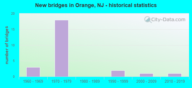
- New bridges - historical statistics
- 31960-1969
- 181970-1979
- 21990-1999
- 12000-2009
- 12010-2019
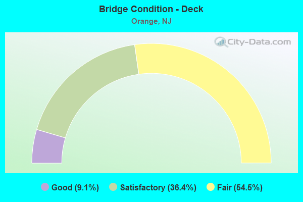
- Bridge Condition - Deck
- 9.1%Good
- 36.4%Satisfactory
- 54.5%Fair
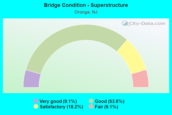
- Bridge Condition - Superstructure
- 9.1%Very good
- 63.6%Good
- 18.2%Satisfactory
- 9.1%Fair
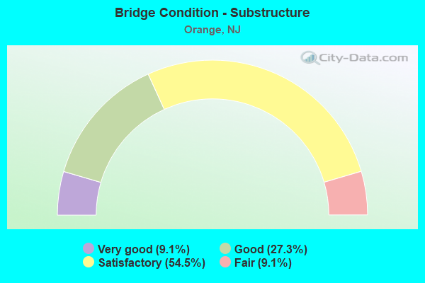
- Bridge Condition - Substructure
- 9.1%Very good
- 27.3%Good
- 54.5%Satisfactory
- 9.1%Fair
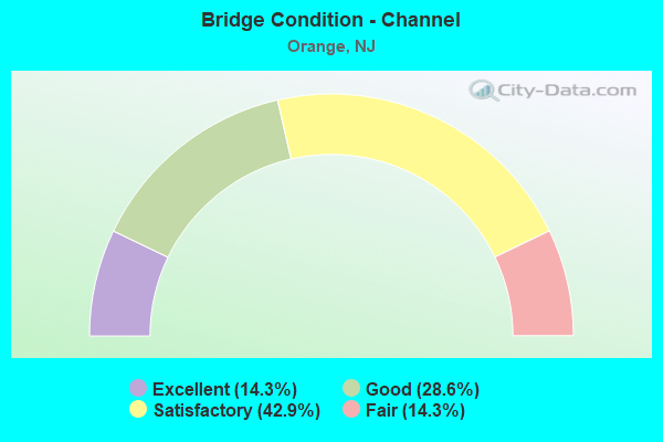
- Bridge Condition - Channel
- 14.3%Excellent
- 28.6%Good
- 42.9%Satisfactory
- 14.3%Fair
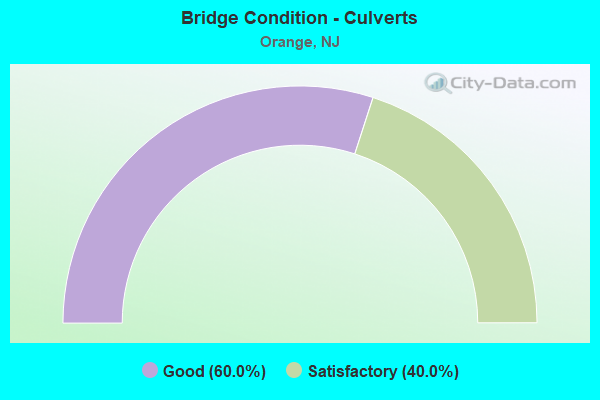
- Bridge Condition - Culverts
- 60.0%Good
- 40.0%Satisfactory
Find on map >> Show street view
Structure Number: 700021, Location: 0.8 mi N of I-280 (Lat: 40.780950, Lng: -74.227611), Route carried "on" structure: County highway 638, Year Built: 2000, Status: Open, Structure Length: 0.67m (2.20ft), Average Daily Traffic: 10,375 (year 2019), Truck Traffic: 4%, Average Future Daily Traffic: 12,450 (year 2039), Design Load: HS 25 or greater, Features Intersected: Second River, Facility Carried by Structure: High Street
Minimum Vertical Clearance: 30+ m (98+ ft), Kilometerpoint: 8.320, Lanes on structure: 2, Owner: County Highway Agency, Approaching Roadway Width: 11.9m (39.0ft), Material/Design: Concrete, Design/Construction: Culvert, Number Of Spans In Main Unit: 1, Length of Maximum Span: 6.7m (22.0ft), Curb or Sidewalk Widths: Left: 3.4m (11.2ft), Right: 3.7m (12.1ft), Curb-To-Curb Width: 12.0m (39.4ft), Out-to-Out Width: 19.7m (64.6ft)
Condition: Channel: Good, Culverts: Good, Operating Rating: 82.6 metric tons, Method Used To Determine Operating Rating: Load Factor (LF), Inventory Rating: 49.0 metric tons, Method Used To Determine Inventory Rating: Load Factor (LF), Structural Evaluation: Better than present minimum criteria, Deck Geometry: Somewhat better than minimum adequacy, Waterway Adequacy: Equal to present desirable criteria, Approach Roadway Alignment: Equal to present desirable criteria, Designated Inspection Frequency: Every 24 months, Inspection Date: July 2021
Find on map >> Show street view
Structure Number: 700032, Location: 150 FT E OF WASHINGTON ST (Lat: 40.780050, Lng: -74.222261), Route carried "on" structure: City street , Year Built: 1964, Status: Open, Structure Length: 1.98m (6.50ft), Average Daily Traffic: 4,937 (year 2021), Truck Traffic: 4%, Average Future Daily Traffic: 5,924 (year 2041), Design Load: HS 20, Features Intersected: Second River, Facility Carried by Structure: Thomas Boulevard
Minimum Vertical Clearance: 30+ m (98+ ft), Kilometerpoint: 0.097, Lanes on structure: 2, Owner: County Highway Agency, Approaching Roadway Width: 7.3m (24.0ft), Skew: 4 degrees, Material/Design: Prestressed concrete, Design/Construction: Box Beam or Girders - Multiple, Number Of Spans In Main Unit: 1, Length of Maximum Span: 18.3m (60.0ft), Curb or Sidewalk Widths: Left: 2.9m (9.5ft), Right: 2.9m (9.5ft), Curb-To-Curb Width: 7.3m (24.0ft), Out-to-Out Width: 13.4m (44.0ft)
Condition: Deck: Fair, Superstructure: Fair, Substructure: Good, Channel: Satisfactory, Operating Rating: 46.3 metric tons, Method Used To Determine Operating Rating: Field evaluation and documented engineering judgment, Inventory Rating: 27.2 metric tons, Method Used To Determine Inventory Rating: Field evaluation and documented engineering judgment, Structural Evaluation: Somewhat better than minimum adequacy, Deck Geometry: High priority of replacement, Waterway Adequacy: Equal to present desirable criteria, Approach Roadway Alignment: Equal to present desirable criteria, Length Of Structure Improvement: 1.98m (6.50ft), Designated Inspection Frequency: Every 24 months, Inspection Date: July 2021, Bridge Improvement Cost: $708,000, Roadway Improvement Cost: $142,000, Total Project Cost: $956,000 ( Estimate for 2021), Deck Structure Type: Concrete Precast Panels, Wearing Surface/Protective System: Wearing Surface: Bituminous
Find on map >> Show street view
Structure Number: 700037, Location: 1000 FT. SOUTH OF DODD ST (Lat: 40.779819, Lng: -74.223350), Route carried "on" structure: City street , Year Built: 1995, Status: Open, Structure Length: 0.67m (2.20ft), Average Daily Traffic: 14,370 (year 2019), Truck Traffic: 4%, Average Future Daily Traffic: 17,250 (year 2039), Design Load: HS 25 or greater, Features Intersected: Second River, Facility Carried by Structure: Washington Street
Minimum Vertical Clearance: 30+ m (98+ ft), Kilometerpoint: 4.603, Lanes on structure: 2, Owner: County Highway Agency, Approaching Roadway Width: 11.0m (36.1ft), Material/Design: Concrete, Design/Construction: Culvert, Number Of Spans In Main Unit: 1, Length of Maximum Span: 6.7m (22.0ft), Curb or Sidewalk Widths: Left: 3.3m (10.8ft), Right: 3.6m (11.8ft), Curb-To-Curb Width: 11.0m (36.1ft), Out-to-Out Width: 18.5m (60.7ft)
Condition: Channel: Good, Culverts: Satisfactory, Operating Rating: 80.7 metric tons, Method Used To Determine Operating Rating: Load Factor (LF), Inventory Rating: 48.1 metric tons, Method Used To Determine Inventory Rating: Load Factor (LF), Structural Evaluation: Equal to present minimum criteria, Deck Geometry: Meets minimum limits, Waterway Adequacy: Equal to present minimum criteria, Approach Roadway Alignment: Equal to present desirable criteria, Designated Inspection Frequency: Every 24 months, Inspection Date: July 2021
Find on map >> Show street view
Structure Number: 700075, Location: 100 FT.SO.WASHINGTON ST. (Lat: 40.779969, Lng: -74.224161), Route carried "on" structure: City street , Year Built: 1994, Status: Open, Structure Length: 0.67m (2.20ft), Average Daily Traffic: 8,302 (year 2020), Truck Traffic: 3%, Average Future Daily Traffic: 10,128 (year 2040), Design Load: HS 25 or greater, Features Intersected: SECOND RIVER, Facility Carried by Structure: NORTH DAY STREET
Minimum Vertical Clearance: 30+ m (98+ ft), Kilometerpoint: 0.032, Lanes on structure: 2, Owner: County Highway Agency, Approaching Roadway Width: 11.0m (36.1ft), Material/Design: Concrete, Design/Construction: Culvert, Number Of Spans In Main Unit: 1, Length of Maximum Span: 6.7m (22.0ft), Curb or Sidewalk Widths: Left: 1.7m (5.6ft), Right: 2.0m (6.6ft), Curb-To-Curb Width: 11.0m (36.1ft), Out-to-Out Width: 15.2m (49.9ft)
Condition: Channel: Excellent, Culverts: Satisfactory, Operating Rating: 89.8 metric tons, Method Used To Determine Operating Rating: Load Factor (LF), Inventory Rating: 76.2 metric tons, Method Used To Determine Inventory Rating: Load Factor (LF), Structural Evaluation: Equal to present minimum criteria, Deck Geometry: Meets minimum limits, Waterway Adequacy: Better than present minimum criteria, Approach Roadway Alignment: Better than present minimum criteria, Designated Inspection Frequency: Every 24 months, Inspection Date: August 2020
Find on map >> Show street view
Structure Number: 70008, Location: .07 mi Nrth of Hayward St (Lat: 40.786419, Lng: -74.219161), Route carried "on" structure: City street , Year Built: 1965, Status: Open, Structure Length: 0.70m (2.30ft), Average Daily Traffic: 8,980 (year 2019), Truck Traffic: 4%, Average Future Daily Traffic: 10,775 (year 2039), Design Load: H 20, Features Intersected: Nishuane Brook, Facility Carried by Structure: Thomas Boulevard
Minimum Vertical Clearance: 30+ m (98+ ft), Kilometerpoint: 0.885, Lanes on structure: 4, Owner: County Highway Agency, Approaching Roadway Width: 14.6m (47.9ft), Skew: 25 degrees, Material/Design: Concrete, Design/Construction: Culvert, Number Of Spans In Main Unit: 1, Length of Maximum Span: 7.0m (23.0ft), Curb or Sidewalk Widths: Left: 2.3m (7.5ft), Right: 2.3m (7.5ft), Curb-To-Curb Width: 14.6m (47.9ft), Out-to-Out Width: 24.1m (79.1ft)
Condition: Channel: Satisfactory, Culverts: Good, Operating Rating: 54.4 metric tons, Method Used To Determine Operating Rating: Load Factor (LF), Inventory Rating: 32.7 metric tons, Method Used To Determine Inventory Rating: Load Factor (LF), Structural Evaluation: Better than present minimum criteria, Deck Geometry: High priority of replacement, Waterway Adequacy: Equal to present desirable criteria, Approach Roadway Alignment: Equal to present desirable criteria, Length Of Structure Improvement: 0.70m (2.30ft), Designated Inspection Frequency: Every 24 months, Inspection Date: July 2021, Bridge Improvement Cost: $31,000, Roadway Improvement Cost: $2,000, Total Project Cost: $35,000 ( Estimate for 2019)
Find on map >> Show street view
Structure Number: 730157, Location: 1.9 MI W OF 280-GSP JCT (Lat: 40.772089, Lng: -74.239800), Route carried "on" structure: City street , Year Built: 1971, Status: Open, Structure Length: 4.94m (16.21ft), Average Daily Traffic: 14,700 (year 2021), Truck Traffic: 1%, Average Future Daily Traffic: 17,600 (year 2041), Design Load: HS 20, Features Intersected: I-280, Facility Carried by Structure: SOUTH JEFFERSON ST
Minimum Vertical Clearance: 30+ m (98+ ft), Kilometerpoint: 0.000, Lanes on structure: 2, Lanes under structure: 8, Owner: State Highway Agency, Approaching Roadway Width: 11.0m (36.1ft), Skew: 1 degrees, Material/Design: Steel continuous, Design/Construction: Stringer/Multi-beam, Number Of Spans In Main Unit: 2, Length of Maximum Span: 25.6m (84.0ft), Curb or Sidewalk Widths: Left: 2.4m (7.9ft), Right: 2.4m (7.9ft), Curb-To-Curb Width: 11.0m (36.1ft), Out-to-Out Width: 16.5m (54.1ft)
Condition: Deck: Fair, Superstructure: Good, Substructure: Satisfactory, Operating Rating: 89.8 metric tons, Method Used To Determine Operating Rating: Load Factor (LF), Inventory Rating: 53.5 metric tons, Method Used To Determine Inventory Rating: Load Factor (LF), Structural Evaluation: Equal to present minimum criteria, Deck Geometry: Meets minimum limits, Underclear: High priority of corrective action, Approach Roadway Alignment: Better than present minimum criteria, Length Of Structure Improvement: 4.94m (16.21ft), Designated Inspection Frequency: Every 24 months, Inspection Date: March 2021, Bridge Improvement Cost: $835,000, Roadway Improvement Cost: $170,000, Total Project Cost: $1,271,000 ( Estimate for 2021), Deck Structure Type: Concrete Cast-file-Place
Find on map >> Show street view
Structure Number: 730159, Location: 1.7 MI W OF I-280/GSP JCT (Lat: 40.770850, Lng: -74.237139), Route carried "on" structure: County highway 638, Year Built: 1971, Status: Open, Structure Length: 4.88m (16.01ft), Average Daily Traffic: 16,500 (year 2021), Truck Traffic: 4%, Average Future Daily Traffic: 19,800 (year 2041), Design Load: HS 20, Features Intersected: I-280, Facility Carried by Structure: SCOTLAND ROAD
Minimum Vertical Clearance: 30+ m (98+ ft), Kilometerpoint: 6.968, Lanes on structure: 4, Lanes under structure: 8, Owner: State Highway Agency, Approaching Roadway Width: 14.0m (45.9ft), Skew: 2 degrees, Material/Design: Steel continuous, Design/Construction: Stringer/Multi-beam, Number Of Spans In Main Unit: 2, Length of Maximum Span: 23.8m (78.1ft), Curb or Sidewalk Widths: Left: 2.4m (7.9ft), Right: 2.4m (7.9ft), Curb-To-Curb Width: 14.0m (45.9ft), Out-to-Out Width: 19.5m (64.0ft)
Condition: Deck: Satisfactory, Superstructure: Good, Substructure: Satisfactory, Operating Rating: 87.1 metric tons, Method Used To Determine Operating Rating: Load Factor (LF), Inventory Rating: 51.7 metric tons, Method Used To Determine Inventory Rating: Load Factor (LF), Structural Evaluation: Equal to present minimum criteria, Deck Geometry: High priority of replacement, Underclear: Somewhat better than minimum adequacy, Approach Roadway Alignment: Better than present minimum criteria, Length Of Structure Improvement: 4.88m (16.01ft), Designated Inspection Frequency: Every 24 months, Inspection Date: March 2021, Bridge Improvement Cost: $96,000, Roadway Improvement Cost: $50,000, Total Project Cost: $187,000 ( Estimate for 2021), Deck Structure Type: Concrete Cast-file-Place
Find on map >> Show street view
Structure Number: 730174, Location: 1.6 MI W OF I-280-GSP JCT (Lat: 40.770489, Lng: -74.235331), Route carried "on" structure: City street , Year Built: 1970, Status: Open, Structure Length: 5.64m (18.50ft), Average Daily Traffic: 7,028 (year 2021), Truck Traffic: 1%, Average Future Daily Traffic: 8,433 (year 2041), Design Load: HS 20, Features Intersected: I-280, Facility Carried by Structure: LINCOLN AVENUE
Minimum Vertical Clearance: 30+ m (98+ ft), Kilometerpoint: 1.790, Lanes on structure: 2, Lanes under structure: 8, Owner: State Highway Agency, Approaching Roadway Width: 11.0m (36.1ft), Skew: 2 degrees, Material/Design: Steel continuous, Design/Construction: Stringer/Multi-beam, Number Of Spans In Main Unit: 2, Length of Maximum Span: 29.6m (97.1ft), Curb or Sidewalk Widths: Left: 2.4m (7.9ft), Right: 2.4m (7.9ft), Curb-To-Curb Width: 11.0m (36.1ft), Out-to-Out Width: 16.5m (54.1ft)
Condition: Deck: Fair, Superstructure: Good, Substructure: Good, Operating Rating: 73.5 metric tons, Method Used To Determine Operating Rating: Load Factor (LF), Inventory Rating: 44.5 metric tons, Method Used To Determine Inventory Rating: Load Factor (LF), Structural Evaluation: Better than present minimum criteria, Deck Geometry: Meets minimum limits, Underclear: High priority of corrective action, Approach Roadway Alignment: Equal to present desirable criteria, Length Of Structure Improvement: 5.64m (18.50ft), Designated Inspection Frequency: Every 24 months, Inspection Date: July 2021, Bridge Improvement Cost: $884,000, Roadway Improvement Cost: $195,000, Total Project Cost: $1,391,000 ( Estimate for 2021), Deck Structure Type: Concrete Cast-file-Place, Wearing Surface/Protective System: Wearing Surface: Monolithic Concrete
Find on map >> Show street view
Structure Number: 730175, Location: 1.5 MI W OF I-280-GSP JCT (Lat: 40.770281, Lng: -74.232531), Route carried "on" structure: City street , Year Built: 1970, Status: Open, Structure Length: 3.87m (12.70ft), Average Daily Traffic: 3,841 (year 2021), Truck Traffic: 1%, Average Future Daily Traffic: 4,687 (year 2041), Design Load: H 20, Features Intersected: I-280, Facility Carried by Structure: ESSEX AVENUE
Minimum Vertical Clearance: 30+ m (98+ ft), Kilometerpoint: 0.644, Lanes on structure: 2, Lanes under structure: 6, Owner: State Highway Agency, Approaching Roadway Width: 9.1m (29.9ft), Skew: 1 degrees, Material/Design: Steel continuous, Design/Construction: Stringer/Multi-beam, Number Of Spans In Main Unit: 2, Length of Maximum Span: 19.5m (64.0ft), Curb or Sidewalk Widths: Left: 2.4m (7.9ft), Right: 2.4m (7.9ft), Curb-To-Curb Width: 9.1m (29.9ft), Out-to-Out Width: 14.6m (47.9ft)
Condition: Deck: Fair, Superstructure: Good, Substructure: Satisfactory, Inventory Rating: 56.2 metric tons, Method Used To Determine Inventory Rating: Load Factor (LF), Structural Evaluation: Equal to present minimum criteria, Deck Geometry: Meets minimum limits, Underclear: High priority of corrective action, Approach Roadway Alignment: Equal to present desirable criteria, Length Of Structure Improvement: 3.87m (12.70ft), Designated Inspection Frequency: Every 24 months, Inspection Date: August 2021, Bridge Improvement Cost: $752,000, Roadway Improvement Cost: $255,000, Total Project Cost: $1,330,000 ( Estimate for 2021), Deck Structure Type: Concrete Cast-file-Place, Wearing Surface/Protective System: Wearing Surface: Monolithic Concrete
Find on map >> Show street view
Structure Number: 730176, Location: 1.4 MI W OF I-280-GSP JCT (Lat: 40.769911, Lng: -74.231331), Route carried "on" structure: City street , Year Built: 1970, Status: Open, Structure Length: 5.43m (17.81ft), Average Daily Traffic: 3,736 (year 2021), Truck Traffic: 3%, Average Future Daily Traffic: 4,559 (year 2041), Design Load: HS 20, Features Intersected: I-280, Facility Carried by Structure: SOUTH DAY STREET
Minimum Vertical Clearance: 30+ m (98+ ft), Kilometerpoint: 1.287, Lanes on structure: 3, Lanes under structure: 6, Owner: State Highway Agency, Approaching Roadway Width: 11.6m (38.1ft), Material/Design: Steel, Design/Construction: Stringer/Multi-beam, Number Of Spans In Main Unit: 2, Length of Maximum Span: 27.4m (89.9ft), Curb or Sidewalk Widths: Left: 2.4m (7.9ft), Right: 2.4m (7.9ft), Curb-To-Curb Width: 11.6m (38.1ft), Out-to-Out Width: 17.1m (56.1ft)
Condition: Deck: Satisfactory, Superstructure: Good, Substructure: Satisfactory, Inventory Rating: 56.2 metric tons, Method Used To Determine Inventory Rating: Load Factor (LF), Structural Evaluation: Equal to present minimum criteria, Deck Geometry: High priority of replacement, Underclear: High priority of corrective action, Approach Roadway Alignment: Equal to present desirable criteria, Length Of Structure Improvement: 5.43m (17.81ft), Designated Inspection Frequency: Every 24 months, Inspection Date: June 2021, Bridge Improvement Cost: $1,527,000, Roadway Improvement Cost: $303,000, Total Project Cost: $2,381,000 ( Estimate for 2021), Deck Structure Type: Concrete Cast-file-Place, Wearing Surface/Protective System: Wearing Surface: Monolithic Concrete
Find on map >> Show street view
Structure Number: 730177, Location: 1.3 MI W OF I-280-GSP JCT (Lat: 40.769219, Lng: -74.229531), Route carried "on" structure: City street , Year Built: 1970, Status: Open, Structure Length: 5.58m (18.31ft), Average Daily Traffic: 21,657 (year 2021), Truck Traffic: 1%, Average Future Daily Traffic: 26,426 (year 2041), Design Load: HS 20, Features Intersected: I-280, Facility Carried by Structure: SOUTH CENTER ST
Minimum Vertical Clearance: 30+ m (98+ ft), Kilometerpoint: 0.000, Lanes on structure: 4, Lanes under structure: 6, Owner: State Highway Agency, Approaching Roadway Width: 14.0m (45.9ft), Skew: 1 degrees, Material/Design: Steel, Design/Construction: Stringer/Multi-beam, Number Of Spans In Main Unit: 2, Length of Maximum Span: 27.4m (89.9ft), Curb or Sidewalk Widths: Left: 2.4m (7.9ft), Right: 2.4m (7.9ft), Curb-To-Curb Width: 14.0m (45.9ft), Out-to-Out Width: 19.5m (64.0ft)
Condition: Deck: Satisfactory, Superstructure: Good, Substructure: Satisfactory, Inventory Rating: 59.0 metric tons, Method Used To Determine Inventory Rating: Load Factor (LF), Structural Evaluation: Equal to present minimum criteria, Deck Geometry: High priority of replacement, Underclear: High priority of corrective action, Approach Roadway Alignment: Equal to present desirable criteria, Length Of Structure Improvement: 5.58m (18.31ft), Designated Inspection Frequency: Every 24 months, Inspection Date: June 2021, Bridge Improvement Cost: $1,512,000, Roadway Improvement Cost: $309,000, Total Project Cost: $2,377,000 ( Estimate for 2021), Deck Structure Type: Concrete Cast-file-Place, Wearing Surface/Protective System: Wearing Surface: Monolithic Concrete
Find on map >> Show street view
Structure Number: 730178, Location: 1.1 MILES WEST GSP (Lat: 40.767781, Lng: -74.227219), Route carried "on" structure: City street , Year Built: 1970, Status: Open, Structure Length: 5.30m (17.39ft), Average Daily Traffic: 5,735 (year 2021), Truck Traffic: 1%, Average Future Daily Traffic: 7,004 (year 2041), Design Load: HS 20, Features Intersected: I-280, Facility Carried by Structure: HICKORY STREET
Minimum Vertical Clearance: 30+ m (98+ ft), Kilometerpoint: 0.000, Lanes on structure: 2, Lanes under structure: 8, Owner: State Highway Agency, Approaching Roadway Width: 9.1m (29.9ft), Material/Design: Steel, Design/Construction: Stringer/Multi-beam, Number Of Spans In Main Unit: 2, Length of Maximum Span: 25.3m (83.0ft), Curb or Sidewalk Widths: Left: 2.4m (7.9ft), Right: 2.4m (7.9ft), Curb-To-Curb Width: 9.1m (29.9ft), Out-to-Out Width: 14.6m (47.9ft)
Condition: Deck: Fair, Superstructure: Good, Substructure: Satisfactory, Operating Rating: 89.8 metric tons, Method Used To Determine Operating Rating: Load Factor (LF), Inventory Rating: 58.1 metric tons, Method Used To Determine Inventory Rating: Load Factor (LF), Structural Evaluation: Equal to present minimum criteria, Deck Geometry: High priority of corrective action, Underclear: High priority of replacement, Approach Roadway Alignment: Equal to present desirable criteria, Length Of Structure Improvement: 5.30m (17.39ft), Designated Inspection Frequency: Every 24 months, Inspection Date: August 2021, Bridge Improvement Cost: $2,439,000, Roadway Improvement Cost: $244,000, Total Project Cost: $4,115,000 ( Estimate for 2019), Deck Structure Type: Concrete Cast-file-Place, Wearing Surface/Protective System: Wearing Surface: Monolithic Concrete
Find on map >> Show street view
Structure Number: 730179, Location: 1.0 MI W OF GSP (Lat: 40.766631, Lng: -74.224539), Route carried "on" structure: City street , Year Built: 1970, Status: Open, Structure Length: 6.61m (21.69ft), Average Daily Traffic: 4,725 (year 2021), Truck Traffic: 1%, Average Future Daily Traffic: 5,771 (year 2041), Design Load: HS 20, Features Intersected: I-280, Facility Carried by Structure: OAKWOOD AVENUE
Minimum Vertical Clearance: 30+ m (98+ ft), Kilometerpoint: 0.000, Lanes on structure: 4, Lanes under structure: 10, Owner: State Highway Agency, Approaching Roadway Width: 14.0m (45.9ft), Skew: 1 degrees, Material/Design: Steel continuous, Design/Construction: Stringer/Multi-beam, Number Of Spans In Main Unit: 4, Length of Maximum Span: 19.5m (64.0ft), Curb or Sidewalk Widths: Left: 2.4m (7.9ft), Right: 2.4m (7.9ft), Curb-To-Curb Width: 14.0m (45.9ft), Out-to-Out Width: 19.5m (64.0ft)
Condition: Deck: Fair, Superstructure: Satisfactory, Substructure: Good, Operating Rating: 64.4 metric tons, Method Used To Determine Operating Rating: Load Factor (LF), Inventory Rating: 38.1 metric tons, Method Used To Determine Inventory Rating: Load Factor (LF), Structural Evaluation: Equal to present minimum criteria, Deck Geometry: High priority of replacement, Underclear: High priority of corrective action, Approach Roadway Alignment: Equal to present desirable criteria, Length Of Structure Improvement: 6.60m (21.65ft), Designated Inspection Frequency: Every 24 months, Inspection Date: August 2021, Bridge Improvement Cost: $133,000, Roadway Improvement Cost: $133,000, Total Project Cost: $317,000 ( Estimate for 2019), Deck Structure Type: Concrete Cast-file-Place, Wearing Surface/Protective System: Wearing Surface: Monolithic Concrete
Find on map >> Show street view
Structure Number: 76618, Location: 0.1 M N of I-280 Overpass (Lat: 40.771531, Lng: -74.236289), Route carried "on" structure: County highway 638, Year Built: 1970, Status: Open, Structure Length: 8.08m (26.51ft), Average Daily Traffic: 16,577 (year 2021), Truck Traffic: 4%, Average Future Daily Traffic: 20,227 (year 2041), Design Load: HS 20, Features Intersected: Morristown Line(MP 11.6)
Minimum Vertical Clearance: 30+ m (98+ ft), Kilometerpoint: 7.145, Lanes on structure: 4, Owner: State Agenciy, Approaching Roadway Width: 14.0m (45.9ft), Skew: 4 degrees, Material/Design: Steel continuous, Design/Construction: Stringer/Multi-beam, Number Of Spans In Main Unit: 4, Length of Maximum Span: 22.9m (75.1ft), Curb or Sidewalk Widths: Left: 1.8m (5.9ft), Right: 1.8m (5.9ft), Curb-To-Curb Width: 14.0m (45.9ft), Out-to-Out Width: 18.3m (60.0ft)
Condition: Deck: Satisfactory, Superstructure: Satisfactory, Substructure: Fair, Operating Rating: 87.1 metric tons, Method Used To Determine Operating Rating: Load Factor (LF), Inventory Rating: 51.7 metric tons, Method Used To Determine Inventory Rating: Load Factor (LF), Structural Evaluation: Somewhat better than minimum adequacy, Deck Geometry: High priority of replacement, Underclear: High priority of corrective action, Approach Roadway Alignment: Somewhat better than minimum adequacy, Length Of Structure Improvement: 8.08m (26.51ft), Designated Inspection Frequency: Every 24 months, Inspection Date: April 2021, Bridge Improvement Cost: $7,560,000, Roadway Improvement Cost: $223,000, Total Project Cost: $16,343,000 ( Estimate for 2021), Deck Structure Type: Concrete Cast-file-Place, Wearing Surface/Protective System: Wearing Surface: Bituminous
Find on map >> Show street view
Structure Number: 1407001, Location: 0.6 miles E of RT 206 (Lat: 40.779911, Lng: -74.683850), Route carried "on" structure: City street , Year Built: 1960, Status: Open, Structure Length: 1.28m (4.20ft), Average Daily Traffic: 1,194 (year 2021), Truck Traffic: 1%, Average Future Daily Traffic: 1,457 (year 2041), Features Intersected: TRIB. TO PEAPACK BROOK, Facility Carried by Structure: COLBY FARM ROAD
Minimum Vertical Clearance: 30+ m (98+ ft), Kilometerpoint: 0.000, Lanes on structure: 2, Owner: Town or Township Highway Agency, Approaching Roadway Width: 9.4m (30.8ft), Material/Design: Concrete, Design/Construction: Culvert, Number Of Spans In Main Unit: 1, Length of Maximum Span: 12.8m (42.0ft), Curb or Sidewalk Widths: Left: 3.4m (11.2ft), Right: 3.0m (9.8ft)
Condition: Channel: Satisfactory, Culverts: Good, Operating Rating: 54.4 metric tons, Method Used To Determine Operating Rating: Field evaluation and documented engineering judgment, Inventory Rating: 32.7 metric tons, Method Used To Determine Inventory Rating: Field evaluation and documented engineering judgment, Structural Evaluation: Better than present minimum criteria, Waterway Adequacy: Equal to present desirable criteria, Approach Roadway Alignment: Better than present minimum criteria, Designated Inspection Frequency: Every 24 months, Inspection Date: August 2021
Find on map >> Show street view
Structure Number: 1410001, Location: 0.03 MILE WEST OF CR 632 (Lat: 40.815300, Lng: -74.387250), Route carried "on" structure: City street , Year Built: 2015, Status: Open, Structure Length: 2.77m (9.09ft), Average Daily Traffic: 6,482 (year 2021), Truck Traffic: 1%, Average Future Daily Traffic: 7,778 (year 2041), Design Load: HL 93, Features Intersected: WHIPPANY RIVER, Facility Carried by Structure: MELANIE LANE
Minimum Vertical Clearance: 30+ m (98+ ft), Kilometerpoint: 0.000, Lanes on structure: 2, Owner: County Highway Agency, Approaching Roadway Width: 12.2m (40.0ft), Material/Design: Concrete, Design/Construction: Box Beam or Girders - Multiple, Number Of Spans In Main Unit: 1, Length of Maximum Span: 26.2m (86.0ft), Curb or Sidewalk Widths: Left: 1.8m (5.9ft), Right: 0.0m, Curb-To-Curb Width: 12.2m (40.0ft), Out-to-Out Width: 15.0m (49.2ft)
Condition: Deck: Good, Superstructure: Very good, Substructure: Very good, Channel: Fair, Operating Rating: 60.3 metric tons, Method Used To Determine Operating Rating: Load and Resistance Factor Rating (LRFR) rating reported by rating factor(RF) method using HL-93 loadings, Inventory Rating: 48.0 metric tons, Method Used To Determine Inventory Rating: Load and Resistance Factor Rating (LRFR) rating reported by rating factor(RF) method using HL-93 loadings, Structural Evaluation: Equal to present desirable criteria, Deck Geometry: Somewhat better than minimum adequacy, Waterway Adequacy: Better than present minimum criteria, Approach Roadway Alignment: Equal to present desirable criteria, Designated Inspection Frequency: Every 24 months, Inspection Date: August 2021, Deck Structure Type: Concrete Cast-file-Place, Wearing Surface/Protective System: Wearing Surface: Monolithic Concrete, Deck Protection: Epoxy Coated Reinforcing
Find on map >> Show street view
Structure Number: 730157, Location: 1.9 MI W OF 280-GSP JCT (Lat: 40.772089, Lng: -74.239800), Route carried "under" structure: Interstate 280, Year Built: 1971, Structure Length: 0. m, Average Daily Traffic: 127,500 (year 2021), Truck Traffic: 9%, Features Intersected: I-280, Facility Carried by Structure: SOUTH JEFFERSON ST
Minimum Vertical Clearance: 5.39m (17.68ft), Kilometerpoint: 16.399, Lanes on structure: 2, Lanes under structure: 8, Material/Design: Steel continuous, Design/Construction: Stringer/Multi-beam, Length of Maximum Span: 25.6m (84.0ft)
Find on map >> Show street view
Structure Number: 730159, Location: 1.7 MI W OF I-280/GSP JCT (Lat: 40.770850, Lng: -74.237139), Route carried "under" structure: Interstate 280, Year Built: 1971, Structure Length: 0. m, Average Daily Traffic: 126,400 (year 2021), Truck Traffic: 9%, Features Intersected: I-280, Facility Carried by Structure: SCOTLAND ROAD
Minimum Vertical Clearance: 8.59m (28.18ft), Kilometerpoint: 16.673, Lanes on structure: 4, Lanes under structure: 8, Material/Design: Steel continuous, Design/Construction: Stringer/Multi-beam, Length of Maximum Span: 23.8m (78.1ft)
Find on map >> Show street view
Structure Number: 730174, Location: 1.6 MI W OF I-280-GSP JCT (Lat: 40.770489, Lng: -74.235331), Route carried "under" structure: Interstate 280, Year Built: 1970, Structure Length: 0. m, Average Daily Traffic: 107,406 (year 2021), Truck Traffic: 9%, Features Intersected: I-280, Facility Carried by Structure: LINCOLN AVENUE
Minimum Vertical Clearance: 4.70m (15.42ft), Kilometerpoint: 16.834, Lanes on structure: 2, Lanes under structure: 8, Material/Design: Steel continuous, Design/Construction: Stringer/Multi-beam, Length of Maximum Span: 29.6m (97.1ft)
Find on map >> Show street view
Structure Number: 730175, Location: 1.5 MI W OF I-280-GSP JCT (Lat: 40.770281, Lng: -74.232531), Route carried "under" structure: Interstate 280, Year Built: 1970, Structure Length: 0. m, Average Daily Traffic: 113,716 (year 2021), Truck Traffic: 9%, Features Intersected: I-280, Facility Carried by Structure: ESSEX AVENUE
Minimum Vertical Clearance: 5.18m (16.99ft), Kilometerpoint: 17.075, Lanes on structure: 2, Lanes under structure: 6, Material/Design: Steel continuous, Design/Construction: Stringer/Multi-beam, Length of Maximum Span: 19.5m (64.0ft)
Find on map >> Show street view
Structure Number: 730176, Location: 1.4 MI W OF I-280-GSP JCT (Lat: 40.769911, Lng: -74.231331), Route carried "under" structure: Interstate 280, Year Built: 1970, Structure Length: 0. m, Average Daily Traffic: 124,837 (year 2021), Truck Traffic: 9%, Features Intersected: I-280, Facility Carried by Structure: SOUTH DAY STREET
Minimum Vertical Clearance: 5.64m (18.50ft), Kilometerpoint: 17.172, Lanes on structure: 3, Lanes under structure: 6, Material/Design: Steel, Design/Construction: Stringer/Multi-beam, Length of Maximum Span: 27.4m (89.9ft)
Find on map >> Show street view
Structure Number: 730177, Location: 1.3 MI W OF I-280-GSP JCT (Lat: 40.769219, Lng: -74.229531), Route carried "under" structure: Interstate 280, Year Built: 1970, Structure Length: 0. m, Average Daily Traffic: 124,851 (year 2021), Truck Traffic: 9%, Features Intersected: I-280, Facility Carried by Structure: SOUTH CENTER ST
Minimum Vertical Clearance: 4.82m (15.81ft), Kilometerpoint: 17.381, Lanes on structure: 4, Lanes under structure: 6, Material/Design: Steel, Design/Construction: Stringer/Multi-beam, Length of Maximum Span: 27.4m (89.9ft)
Find on map >> Show street view
Structure Number: 730178, Location: 1.1 MILES WEST GSP (Lat: 40.767781, Lng: -74.227219), Route carried "under" structure: Interstate 280, Year Built: 1970, Structure Length: 0. m, Average Daily Traffic: 100,886 (year 2021), Truck Traffic: 9%, Features Intersected: I-280, Facility Carried by Structure: HICKORY STREET
Minimum Vertical Clearance: 4.52m (14.83ft), Kilometerpoint: 17.638, Lanes on structure: 2, Lanes under structure: 8, Material/Design: Steel, Design/Construction: Stringer/Multi-beam, Length of Maximum Span: 25.3m (83.0ft)
Find on map >> Show street view
Structure Number: 730179, Location: 1.0 MI W OF GSP (Lat: 40.766631, Lng: -74.224539), Route carried "under" structure: Interstate 280, Year Built: 1970, Structure Length: 0. m, Average Daily Traffic: 100,886 (year 2021), Truck Traffic: 9%, Features Intersected: I-280, Facility Carried by Structure: OAKWOOD AVENUE
Minimum Vertical Clearance: 5.18m (16.99ft), Kilometerpoint: 17.896, Lanes on structure: 4, Lanes under structure: 6, Material/Design: Steel continuous, Design/Construction: Stringer/Multi-beam, Length of Maximum Span: 19.5m (64.0ft)
Find on map >> Show street view
Structure Number: 730179, Location: 1.0 MI W OF GSP (Lat: 40.766631, Lng: -74.224539), Route carried "under" structure: Ramp Interstate 280, Year Built: 1970, Structure Length: 0. m, Average Daily Traffic: 5,503 (year 2021), Truck Traffic: 9%, Features Intersected: I-280, Facility Carried by Structure: OAKWOOD AVENUE
Minimum Vertical Clearance: 4.50m (14.76ft), Kilometerpoint: 17.896, Lanes on structure: 4, Lanes under structure: 4, Material/Design: Steel continuous, Design/Construction: Stringer/Multi-beam, Length of Maximum Span: 19.5m (64.0ft)