Bridge Statistics for Opa-locka North, Florida (FL)
Condition, Traffic, Stress, Structural Evaluation, Project Costs
- National Bridge Inventory (NBI) Statistics
- 13Number of bridges
- 148ft / 45.5mTotal length
- 704,295Total average daily traffic
- 36,753Total average daily truck traffic
- National Bridge Inventory (NBI) Registered Bridges for Opa-locka North
- No street view available for this location
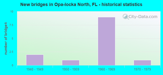
- New bridges - historical statistics
- 21940-1949
- 11950-1959
- 91960-1969
- 11970-1979

- Reconstructed bridges - Historical Statistics
- 31970-1979
- 21980-1989


- Bridge Condition - Deck
- 90.0%Good
- 10.0%Poor

- Bridge Condition - Superstructure
- 10.0%Very good
- 80.0%Good
- 10.0%Poor

- Bridge Condition - Substructure
- 20.0%Very good
- 80.0%Good

- Bridge Condition - Channel
- 28.6%Very good
- 42.9%Good
- 14.3%Fair
- 14.3%Poor
Find on map >> Show street view
Structure Number: 870074, Location: 0.14M N OF NW 151 ST (Lat: 25.916750, Lng: -80.211889), Route carried "on" structure: US 441, Year Built: 1956, Status: Open, Structure Length: 3.23m (10.60ft), Average Daily Traffic: 28,500 (year 2020), Truck Traffic: 7%, Average Future Daily Traffic: 49,448 (year 2042), Design Load: HL 93, Features Intersected: BISCAYNE CANAL C-8, Facility Carried by Structure: COMP SR-7
Minimum Vertical Clearance: 30+ m (98+ ft), Kilometerpoint: 16.787, Lanes on structure: 6, Owner: State Highway Agency, Approaching Roadway Width: 25.6m (84.0ft), Skew: 20 degrees, Material/Design: Concrete, Design/Construction: Slab, Number Of Spans In Main Unit: 5, Length of Maximum Span: 7.6m (24.9ft), Curb or Sidewalk Widths: Left: 2.0m (6.6ft), Right: 2.0m (6.6ft), Curb-To-Curb Width: 20.7m (67.9ft), Out-to-Out Width: 30.5m (100.1ft)
Condition: Deck: Good, Superstructure: Good, Substructure: Good, Channel: Good, Operating Rating: 36.8 metric tons, Method Used To Determine Operating Rating: Load and Resistance Factor (LRFR), Inventory Rating: 28.5 metric tons, Method Used To Determine Inventory Rating: Load and Resistance Factor (LRFR), Structural Evaluation: Better than present minimum criteria, Deck Geometry: High priority of replacement, Waterway Adequacy: Better than present minimum criteria, Approach Roadway Alignment: Equal to present desirable criteria, Designated Inspection Frequency: Every 24 months, Underwater Inspection Frequency: Every 24 months, Inspection Date: May 2020, Underwater Inspection Date: May 2020, Deck Structure Type: Concrete Cast-file-Place, Wearing Surface/Protective System: Wearing Surface: Monolithic Concrete
Find on map >> Show street view
Structure Number: 870091, Location: 0.66M W OF SR-7 (Lat: 25.916153, Lng: -80.222511), Route carried "on" structure: State highway 9, Year Built: 1949, Status: Open, Structure Length: 6.04m (19.82ft), Average Daily Traffic: 12,272 (year 2020), Truck Traffic: 9%, Average Future Daily Traffic: 21,292 (year 2042), Design Load: HS 20, Features Intersected: BISCAYNE CANAL C-8
Minimum Vertical Clearance: 30+ m (98+ ft), Kilometerpoint: 20.608, Lanes on structure: 2, Owner: State Highway Agency, Approaching Roadway Width: 11.1m (36.4ft), Skew: 3 degrees, Material/Design: Concrete, Design/Construction: Tee Beam, Number Of Spans In Main Unit: 6, Length of Maximum Span: 10.1m (33.1ft), Curb or Sidewalk Widths: Left: 0.4m (1.3ft), Right: 0.4m (1.3ft), Curb-To-Curb Width: 8.5m (27.9ft), Out-to-Out Width: 10.1m (33.1ft)
Condition: Deck: Good, Superstructure: Good, Substructure: Good, Channel: Very good, Operating Rating: 63.0 metric tons, Method Used To Determine Operating Rating: Load Factor (LF), Inventory Rating: 37.7 metric tons, Method Used To Determine Inventory Rating: Load Factor (LF), Structural Evaluation: Better than present minimum criteria, Deck Geometry: High priority of corrective action, Waterway Adequacy: Equal to present desirable criteria, Approach Roadway Alignment: Equal to present desirable criteria, Designated Inspection Frequency: Every 24 months, Underwater Inspection Frequency: Every 24 months, Inspection Date: Febuary 2021, Underwater Inspection Date: Febuary 2021, Deck Structure Type: Concrete Cast-file-Place, Wearing Surface/Protective System: Wearing Surface: Monolithic Concrete
Find on map >> Show street view
Structure Number: 870092, Location: 0.66M W OF SR-7 (Lat: 25.916169, Lng: -80.222778), Route carried "on" structure: State highway 9, Year Built: 1949, Status: Open, Structure Length: 6.04m (19.82ft), Average Daily Traffic: 12,272 (year 2020), Truck Traffic: 9%, Average Future Daily Traffic: 21,292 (year 2042), Design Load: HS 20, Features Intersected: BISCAYNE CANAL C-8
Minimum Vertical Clearance: 30+ m (98+ ft), Kilometerpoint: 20.608, Lanes on structure: 2, Owner: State Highway Agency, Approaching Roadway Width: 10.5m (34.4ft), Skew: 3 degrees, Material/Design: Concrete, Design/Construction: Tee Beam, Number Of Spans In Main Unit: 6, Length of Maximum Span: 10.1m (33.1ft), Curb or Sidewalk Widths: Left: 0.4m (1.3ft), Right: 0.4m (1.3ft), Curb-To-Curb Width: 8.5m (27.9ft), Out-to-Out Width: 10.1m (33.1ft)
Condition: Deck: Good, Superstructure: Good, Substructure: Good, Channel: Very good, Operating Rating: 63.0 metric tons, Method Used To Determine Operating Rating: Load Factor (LF), Inventory Rating: 37.7 metric tons, Method Used To Determine Inventory Rating: Load Factor (LF), Structural Evaluation: Better than present minimum criteria, Deck Geometry: High priority of corrective action, Waterway Adequacy: Equal to present desirable criteria, Approach Roadway Alignment: Equal to present desirable criteria, Designated Inspection Frequency: Every 24 months, Underwater Inspection Frequency: Every 24 months, Inspection Date: Febuary 2021, Underwater Inspection Date: Febuary 2021, Deck Structure Type: Concrete Cast-file-Place, Wearing Surface/Protective System: Wearing Surface: Monolithic Concrete
Find on map >> Show street view
Structure Number: 870151, Location: NW 27Av & Biscayne Canal (Lat: 25.915483, Lng: -80.244297), Route carried "on" structure: State highway 817, Year Built: 1961, Year Reconstructed: 1976, Status: Open, Structure Length: 3.05m (10.01ft), Average Daily Traffic: 37,000 (year 2020), Truck Traffic: 8%, Average Future Daily Traffic: 64,195 (year 2042), Design Load: HL 93, Features Intersected: BISCAYNE CANAL C-8
Minimum Vertical Clearance: 30+ m (98+ ft), Kilometerpoint: 1.574, Lanes on structure: 6, Owner: State Highway Agency, Approaching Roadway Width: 26.5m (86.9ft), Skew: 20 degrees, Material/Design: Prestressed concrete, Design/Construction: Stringer/Multi-beam, Number Of Spans In Main Unit: 2, Length of Maximum Span: 15.2m (49.9ft), Curb or Sidewalk Widths: Left: 1.2m (3.9ft), Right: 1.2m (3.9ft), Curb-To-Curb Width: 26.5m (86.9ft), Out-to-Out Width: 30.5m (100.1ft)
Condition: Deck: Good, Superstructure: Good, Substructure: Good, Channel: Good, Operating Rating: 54.2 metric tons, Method Used To Determine Operating Rating: Load and Resistance Factor (LRFR), Inventory Rating: 39.8 metric tons, Method Used To Determine Inventory Rating: Load and Resistance Factor (LRFR), Structural Evaluation: Better than present minimum criteria, Deck Geometry: Equal to present minimum criteria, Waterway Adequacy: Better than present minimum criteria, Approach Roadway Alignment: Equal to present desirable criteria, Designated Inspection Frequency: Every 24 months, Underwater Inspection Frequency: Every 24 months, Inspection Date: June 2020, Underwater Inspection Date: June 2020, Deck Structure Type: Concrete Cast-file-Place, Wearing Surface/Protective System: Wearing Surface: Bituminous
Find on map >> Show street view
Structure Number: 870248, Location: 0.5MI W OF SR-817 (Lat: 25.925981, Lng: -80.252583), Route carried "on" structure: State highway 826, Year Built: 1965, Year Reconstructed: 1993, Status: Open, Structure Length: 5.46m (17.91ft), Average Daily Traffic: 73,500 (year 2019), Truck Traffic: 6%, Average Future Daily Traffic: 127,522 (year 2041), Design Load: HL 93, Features Intersected: NW 32ND AVE
Minimum Vertical Clearance: 30+ m (98+ ft), Kilometerpoint: 34.577, Lanes on structure: 3, Lanes under structure: 4, Base Highway Network: Yes, Toll: On toll road, Owner: State Highway Agency, Approaching Roadway Width: 16.1m (52.8ft), Material/Design: Prestressed concrete, Design/Construction: Stringer/Multi-beam, Number Of Spans In Main Unit: 4, Length of Maximum Span: 16.5m (54.1ft), Curb-To-Curb Width: 16.1m (52.8ft), Out-to-Out Width: 17.0m (55.8ft)
Condition: Deck: Good, Superstructure: Good, Substructure: Good, Operating Rating: 49.4 metric tons, Method Used To Determine Operating Rating: Load and Resistance Factor (LRFR), Inventory Rating: 34.7 metric tons, Method Used To Determine Inventory Rating: Load and Resistance Factor (LRFR), Structural Evaluation: Better than present minimum criteria, Deck Geometry: Equal to present minimum criteria, Underclear: Meets minimum limits, Approach Roadway Alignment: Equal to present desirable criteria, Designated Inspection Frequency: Every 24 months, Inspection Date: April 2021, Deck Structure Type: Concrete Cast-file-Place
Find on map >> Show street view
Structure Number: 870347, Location: 1MI. NORTH OF SR-916 (Lat: 25.913083, Lng: -80.210194), Route carried "on" structure: Interstate 95, Year Built: 1963, Year Reconstructed: 1976, Status: Open, Structure Length: 5.53m (18.14ft), Average Daily Traffic: 117,000 (year 2020), Truck Traffic: 5%, Average Future Daily Traffic: 202,995 (year 2042), Design Load: HL 93, Features Intersected: NW 151 ST
Minimum Vertical Clearance: 30+ m (98+ ft), Kilometerpoint: 18.940, Lanes on structure: 6, Lanes under structure: 4, Base Highway Network: Yes, Toll: On Interstate toll segment, Owner: State Highway Agency, Approaching Roadway Width: 25.8m (84.6ft), Material/Design: Prestressed concrete, Design/Construction: Stringer/Multi-beam, Number Of Spans In Main Unit: 4, Length of Maximum Span: 15.8m (51.8ft), Curb-To-Curb Width: 25.8m (84.6ft), Out-to-Out Width: 26.7m (87.6ft)
Condition: Deck: Good, Superstructure: Very good, Substructure: Very good, Operating Rating: 35.3 metric tons, Method Used To Determine Operating Rating: Load and Resistance Factor (LRFR), Inventory Rating: 27.1 metric tons, Method Used To Determine Inventory Rating: Load and Resistance Factor (LRFR), Structural Evaluation: Equal to present minimum criteria, Deck Geometry: Meets minimum limits, Underclear: Somewhat better than minimum adequacy, Approach Roadway Alignment: Equal to present desirable criteria, Designated Inspection Frequency: Every 24 months, Inspection Date: June 2021, Deck Structure Type: Concrete Cast-file-Place
Find on map >> Show street view
Structure Number: 870348, Location: 0.5M S OF Golden Glades I (Lat: 25.916758, Lng: -80.210250), Route carried "on" structure: Interstate 95, Year Built: 1961, Year Reconstructed: 1975, Status: Open, Structure Length: 3.57m (11.71ft), Average Daily Traffic: 234,000 (year 2020), Truck Traffic: 5%, Average Future Daily Traffic: 405,990 (year 2042), Design Load: HL 93, Features Intersected: BISCAYNE CANAL C-8
Minimum Vertical Clearance: 30+ m (98+ ft), Kilometerpoint: 19.375, Lanes on structure: 12, Base Highway Network: Yes, Toll: On Interstate toll segment, Owner: State Highway Agency, Approaching Roadway Width: 56.5m (185.4ft), Skew: 30 degrees, Material/Design: Prestressed concrete, Design/Construction: Slab, Number Of Spans In Main Unit: 3, Length of Maximum Span: 11.9m (39.0ft), Curb-To-Curb Width: 56.5m (185.4ft), Out-to-Out Width: 58.4m (191.6ft)
Condition: Deck: Good, Superstructure: Good, Substructure: Good, Channel: Good, Operating Rating: 50.3 metric tons, Method Used To Determine Operating Rating: Load and Resistance Factor (LRFR), Inventory Rating: 43.7 metric tons, Method Used To Determine Inventory Rating: Load and Resistance Factor (LRFR), Structural Evaluation: Better than present minimum criteria, Deck Geometry: Superior to present desirable criteria, Waterway Adequacy: Better than present minimum criteria, Approach Roadway Alignment: Equal to present desirable criteria, Designated Inspection Frequency: Every 24 months, Underwater Inspection Frequency: Every 24 months, Inspection Date: July 2020, Underwater Inspection Date: July 2020, Deck Structure Type: Concrete Precast Panels, Wearing Surface/Protective System: Wearing Surface: Bituminous
Find on map >> Show street view
Structure Number: 870446, Location: 1MI. NORTH OF SR-916 (Lat: 25.913083, Lng: -80.209972), Route carried "on" structure: Interstate 95, Year Built: 1963, Year Reconstructed: 1994, Status: Open, Structure Length: 5.56m (18.24ft), Average Daily Traffic: 117,000 (year 2020), Truck Traffic: 5%, Average Future Daily Traffic: 202,995 (year 2042), Design Load: HL 93, Features Intersected: NW 151ST ST.
Minimum Vertical Clearance: 30+ m (98+ ft), Kilometerpoint: 18.940, Lanes on structure: 6, Lanes under structure: 4, Base Highway Network: Yes, Toll: On Interstate toll segment, Owner: State Highway Agency, Approaching Roadway Width: 25.8m (84.6ft), Material/Design: Prestressed concrete, Design/Construction: Stringer/Multi-beam, Number Of Spans In Main Unit: 4, Length of Maximum Span: 15.9m (52.2ft), Curb-To-Curb Width: 25.8m (84.6ft), Out-to-Out Width: 26.7m (87.6ft)
Condition: Deck: Good, Superstructure: Good, Substructure: Very good, Operating Rating: 35.3 metric tons, Method Used To Determine Operating Rating: Load and Resistance Factor (LRFR), Inventory Rating: 27.1 metric tons, Method Used To Determine Inventory Rating: Load and Resistance Factor (LRFR), Structural Evaluation: Equal to present minimum criteria, Deck Geometry: Meets minimum limits, Underclear: Meets minimum limits, Approach Roadway Alignment: Equal to present desirable criteria, Designated Inspection Frequency: Every 24 months, Inspection Date: June 2021, Deck Structure Type: Concrete Cast-file-Place
Find on map >> Show street view
Structure Number: 87403, Location: 0.2 Mile N of NW 151 St (Lat: 25.915694, Lng: -80.236214), Route carried "on" structure: County highway , Year Built: 1964, Status: Open, Structure Length: 3.41m (11.19ft), Average Daily Traffic: 17,776 (year 2021), Truck Traffic: 2%, Average Future Daily Traffic: 30,841 (year 2042), Design Load: HS 20, Features Intersected: Biscayne Canal C-8, Facility Carried by Structure: NW 22nd Avenue
Minimum Vertical Clearance: 30+ m (98+ ft), Kilometerpoint: 0.866, Lanes on structure: 4, Owner: County Highway Agency, Approaching Roadway Width: 20.4m (66.9ft), Skew: 20 degrees, Material/Design: Prestressed concrete, Design/Construction: Slab, Number Of Spans In Main Unit: 3, Length of Maximum Span: 11.4m (37.4ft), Curb or Sidewalk Widths: Left: 1.2m (3.9ft), Right: 1.2m (3.9ft), Curb-To-Curb Width: 22.3m (73.2ft), Out-to-Out Width: 25.3m (83.0ft)
Condition: Deck: Poor, Superstructure: Poor, Substructure: Good, Channel: Poor, Operating Rating: 65.6 metric tons, Method Used To Determine Operating Rating: Load Factor (LF), Inventory Rating: 39.3 metric tons, Method Used To Determine Inventory Rating: Load Factor (LF), Structural Evaluation: Meets minimum limits, Deck Geometry: Superior to present desirable criteria, Waterway Adequacy: Better than present minimum criteria, Approach Roadway Alignment: Equal to present desirable criteria, Designated Inspection Frequency: Every 24 months, Underwater Inspection Frequency: Every 12 months, Other Special Inspection Frequency: Every 12 months, Inspection Date: June 2021, Underwater Inspection Date: June 2021, Other Special Inspection Date: June 2021, Deck Structure Type: Concrete Precast Panels, Wearing Surface/Protective System: Wearing Surface: Bituminous
Find on map >> Show street view
Structure Number: 874362, Location: 0.2Mile N of NW 151st St. (Lat: 25.916778, Lng: -80.209861), Route carried "on" structure: County highway , Year Built: 1973, Status: Open, Structure Length: 3.56m (11.68ft), Average Daily Traffic: 2,081 (year 2020), Truck Traffic: 2%, Average Future Daily Traffic: 2,383 (year 2042), Design Load: HS 20, Features Intersected: Biscayne Canal, Facility Carried by Structure: NW 6th Avenue
Minimum Vertical Clearance: 30+ m (98+ ft), Kilometerpoint: 1.662, Lanes on structure: 2, Owner: County Highway Agency, Approaching Roadway Width: 7.9m (25.9ft), Material/Design: Prestressed concrete, Design/Construction: Slab, Number Of Spans In Main Unit: 3, Length of Maximum Span: 11.9m (39.0ft), Curb or Sidewalk Widths: Left: 0.6m (2.0ft), Right: 1.6m (5.2ft), Curb-To-Curb Width: 10.2m (33.5ft), Out-to-Out Width: 12.9m (42.3ft)
Condition: Deck: Good, Superstructure: Good, Substructure: Good, Channel: Fair, Operating Rating: 53.1 metric tons, Method Used To Determine Operating Rating: Load Factor (LF), Inventory Rating: 31.8 metric tons, Method Used To Determine Inventory Rating: Load Factor (LF), Structural Evaluation: Better than present minimum criteria, Deck Geometry: Meets minimum limits, Waterway Adequacy: Equal to present desirable criteria, Approach Roadway Alignment: Equal to present desirable criteria, Designated Inspection Frequency: Every 24 months, Underwater Inspection Frequency: Every 24 months, Inspection Date: July 2020, Underwater Inspection Date: July 2020, Deck Structure Type: Concrete Precast Panels, Wearing Surface/Protective System: Wearing Surface: Bituminous
Find on map >> Show street view
Structure Number: 870248, Location: 0.5MI W OF SR-817 (Lat: 25.925981, Lng: -80.252583), Route carried "under" structure: City street , Year Built: 1965, Structure Length: 0. m, Average Daily Traffic: 8,200 (year 2020), Truck Traffic: 6%, Features Intersected: NW 32ND AVE, Facility Carried by Structure: SR-826 EB (870048)
Minimum Vertical Clearance: 4.30m (14.11ft), Kilometerpoint: 1.588, Lanes on structure: 3, Lanes under structure: 4, Material/Design: Prestressed concrete, Design/Construction: Stringer/Multi-beam, Length of Maximum Span: 16.5m (54.1ft)
Find on map >> Show street view
Structure Number: 870347, Location: 1MI. NORTH OF SR-916 (Lat: 25.913083, Lng: -80.210194), Route carried "under" structure: City street , Year Built: 1963, Structure Length: 0. m, Average Daily Traffic: 22,347 (year 2021), Truck Traffic: 2%, Features Intersected: NW 151 ST, Facility Carried by Structure: I-95 SB
Minimum Vertical Clearance: 4.36m (14.30ft), Kilometerpoint: 0.000, Lanes on structure: 6, Lanes under structure: 3, Material/Design: Prestressed concrete, Design/Construction: Stringer/Multi-beam, Length of Maximum Span: 15.8m (51.8ft)
Find on map >> Show street view
Structure Number: 870446, Location: 1MI. NORTH OF SR-916 (Lat: 25.913083, Lng: -80.209972), Route carried "under" structure: City street , Year Built: 1963, Structure Length: 0. m, Average Daily Traffic: 22,347 (year 2021), Truck Traffic: 2%, Features Intersected: NW 151ST ST., Facility Carried by Structure: I-95 NB
Minimum Vertical Clearance: 4.27m (14.01ft), Kilometerpoint: 0.000, Lanes on structure: 6, Lanes under structure: 3, Material/Design: Prestressed concrete, Design/Construction: Stringer/Multi-beam, Length of Maximum Span: 15.9m (52.2ft)