Bridge Statistics for Olyphant, Pennsylvania (PA)
Condition, Traffic, Stress, Structural Evaluation, Project Costs
- National Bridge Inventory (NBI) Statistics
- 11Number of bridges
- 72ft / 22.5mTotal length
- 56,074Total average daily traffic
- 4,169Total average daily truck traffic
- National Bridge Inventory (NBI) Registered Bridges for Olyphant
- No street view available for this location
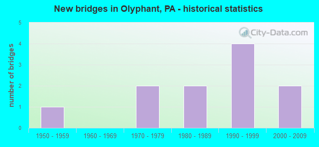
- New bridges - historical statistics
- 11950-1959
- 21970-1979
- 21980-1989
- 41990-1999
- 22000-2009


- Bridge Condition - Deck
- 40.0%Very good
- 40.0%Good
- 20.0%Satisfactory

- Bridge Condition - Superstructure
- 40.0%Very good
- 40.0%Good
- 20.0%Fair

- Bridge Condition - Substructure
- 60.0%Good
- 20.0%Satisfactory
- 20.0%Fair

- Bridge Condition - Channel
- 16.7%Very good
- 50.0%Satisfactory
- 16.7%Fair
- 16.7%Poor

- Bridge Condition - Culverts
- 25.0%Very good
- 25.0%Good
- 25.0%Satisfactory
- 25.0%Serious
Find on map >> Show street view
Structure Number: 337, Location: 25' west of sr 0066 (Lat: 40.664922, Lng: -79.604944), Route carried "on" structure: City street , Year Built: 1951, Status: Posted for load, Structure Length: 0.73m (2.40ft), Average Daily Traffic: 300 (year 2021), Truck Traffic: 9%, Average Future Daily Traffic: 420 (year 2041), Design Load: HS 20, Features Intersected: ELDER RUN, Facility Carried by Structure: T-406 GODFREY ROAD
Minimum Vertical Clearance: 30+ m (98+ ft), Kilometerpoint: 0.000, Lanes on structure: 2, Owner: Town or Township Highway Agency, Approaching Roadway Width: 6.1m (20.0ft), Skew: 1 degrees, Material/Design: Concrete, Design/Construction: Tee Beam, Number Of Spans In Main Unit: 1, Length of Maximum Span: 7.0m (23.0ft), Curb or Sidewalk Widths: Left: 0.2m (0.7ft), Right: 1.5m (4.9ft), Curb-To-Curb Width: 7.6m (24.9ft), Out-to-Out Width: 9.6m (31.5ft)
Condition: Deck: Satisfactory, Superstructure: Good, Substructure: Fair, Channel: Poor, Operating Rating: 34.5 metric tons, Method Used To Determine Operating Rating: Load Factor (LF), Inventory Rating: 20.9 metric tons, Method Used To Determine Inventory Rating: Load Factor (LF), Structural Evaluation: Somewhat better than minimum adequacy, Deck Geometry: Somewhat better than minimum adequacy, Waterway Adequacy: Better than present minimum criteria, Approach Roadway Alignment: Equal to present desirable criteria, Bridge Posting: Required (Relationship of Operating Rating to Maximum Legal Load: 10.0 - 19.9% below), Length Of Structure Improvement: 1.40m (4.59ft), Designated Inspection Frequency: Every 24 months, Other Special Inspection Frequency: Every 12 months, Inspection Date: June 2021, Other Special Inspection Date: June 2021, Deck Structure Type: Concrete Cast-file-Place, Wearing Surface/Protective System: Wearing Surface: Bituminous
Find on map >> Show street view
Structure Number: 558, Location: NEWRY BOROUGH (Lat: 40.394086, Lng: -78.430822), Route carried "on" structure: Interstate 99, Year Built: 1987, Year Reconstructed: 2013, Status: Open, Structure Length: 4.21m (13.81ft), Average Daily Traffic: 10,325 (year 2021), Truck Traffic: 15%, Average Future Daily Traffic: 12,358 (year 2032), Design Load: HS 25 or greater, Features Intersected: T373 (CATFISH ROAD)
Minimum Vertical Clearance: 30+ m (98+ ft), Kilometerpoint: 16.237, Lanes on structure: 2, Lanes under structure: 2, Base Highway Network: Yes, Owner: State Highway Agency, Approaching Roadway Width: 11.6m (38.1ft), Skew: 10 degrees, Material/Design: Prestressed concrete, Design/Construction: Box Beam or Girders - Single/Spread, Number Of Spans In Main Unit: 3, Length of Maximum Span: 15.2m (49.9ft), Curb or Sidewalk Widths: Left: 0.2m (0.7ft), Right: 0.2m (0.7ft), Curb-To-Curb Width: 12.8m (42.0ft), Out-to-Out Width: 13.9m (45.6ft)
Condition: Deck: Good, Superstructure: Fair, Substructure: Satisfactory, Operating Rating: 68.0 metric tons, Method Used To Determine Operating Rating: Load Factor (LF), Inventory Rating: 39.9 metric tons, Method Used To Determine Inventory Rating: Load Factor (LF), Structural Evaluation: Somewhat better than minimum adequacy, Deck Geometry: Equal to present desirable criteria, Underclear: Superior to present desirable criteria, Approach Roadway Alignment: Equal to present desirable criteria, Length Of Structure Improvement: 5.10m (16.73ft), Designated Inspection Frequency: Every 24 months, Inspection Date: July 2020, Deck Structure Type: Concrete Cast-file-Place, Wearing Surface/Protective System: Wearing Surface: Epoxy Overlay, Deck Protection: Epoxy Coated Reinforcing
Find on map >> Show street view
Structure Number: 20575, Location: OLYPHANT - BLAKELY LINE (Lat: 41.470717, Lng: -75.606472), Route carried "on" structure: Spur State highway 347, Year Built: 1989, Status: Open, Structure Length: 4.88m (16.01ft), Average Daily Traffic: 11,270 (year 2020), Truck Traffic: 2%, Average Future Daily Traffic: 7,864 (year 2032), Design Load: HS 25 or greater, Features Intersected: LACKAWANNA RIVER
Minimum Vertical Clearance: 30+ m (98+ ft), Kilometerpoint: 6.249, Lanes on structure: 2, Base Highway Network: Yes, Owner: State Highway Agency, Approaching Roadway Width: 10.7m (35.1ft), Material/Design: Prestressed concrete, Design/Construction: Box Beam or Girders - Multiple, Number Of Spans In Main Unit: 2, Length of Maximum Span: 26.8m (87.9ft), Curb or Sidewalk Widths: Left: 1.8m (5.9ft), Right: 1.8m (5.9ft), Curb-To-Curb Width: 10.7m (35.1ft), Out-to-Out Width: 15.1m (49.5ft)
Condition: Deck: Good, Superstructure: Good, Substructure: Good, Channel: Satisfactory, Inventory Rating: 52.6 metric tons, Method Used To Determine Inventory Rating: Load Factor (LF), Structural Evaluation: Better than present minimum criteria, Deck Geometry: Meets minimum limits, Waterway Adequacy: Equal to present desirable criteria, Approach Roadway Alignment: Better than present minimum criteria, Length Of Structure Improvement: 5.79m (19.00ft), Designated Inspection Frequency: Every 24 months, Inspection Date: May 2020, Deck Structure Type: Concrete Cast-file-Place, Wearing Surface/Protective System: Wearing Surface: Monolithic Concrete, Deck Protection: Epoxy Coated Reinforcing
Find on map >> Show street view
Structure Number: 3288, Location: 1 MI SW OF TIOGA (Lat: 41.907283, Lng: -77.161739), Route carried "on" structure: State highway 287, Year Built: 1975, Status: Open, Structure Length: 0.79m (2.59ft), Average Daily Traffic: 2,142 (year 2020), Truck Traffic: 8%, Average Future Daily Traffic: 4,948 (year 2032), Design Load: HS 20, Features Intersected: OVER ELKHORN CREEK
Minimum Vertical Clearance: 30+ m (98+ ft), Kilometerpoint: 45.807, Lanes on structure: 2, Base Highway Network: Yes, Owner: State Highway Agency, Approaching Roadway Width: 11.0m (36.1ft), Material/Design: Concrete, Design/Construction: Culvert, Number Of Spans In Main Unit: 2, Length of Maximum Span: 3.7m (12.1ft)
Condition: Channel: Satisfactory, Culverts: Satisfactory, Operating Rating: 89.8 metric tons, Method Used To Determine Operating Rating: Load Factor (LF), Inventory Rating: 89.8 metric tons, Method Used To Determine Inventory Rating: Load Factor (LF), Structural Evaluation: Equal to present minimum criteria, Waterway Adequacy: Superior to present desirable criteria, Approach Roadway Alignment: Equal to present desirable criteria, Length Of Structure Improvement: 0.80m (2.62ft), Designated Inspection Frequency: Every 48 months, Inspection Date: June 2019
Find on map >> Show street view
Structure Number: 39555, Location: OLYPHANT BORO OV LACK AVE (Lat: 41.453836, Lng: -75.577633), Route carried "on" structure: US 6, Year Built: 1996, Status: Open, Structure Length: 4.30m (14.11ft), Average Daily Traffic: 10,769 (year 2022), Truck Traffic: 9%, Average Future Daily Traffic: 12,514 (year 2032), Design Load: HS 25 or greater, Features Intersected: E LACKAWANNA AVE EXIT 2
Minimum Vertical Clearance: 30+ m (98+ ft), Kilometerpoint: 19.172, Lanes on structure: 2, Lanes under structure: 2, Base Highway Network: Yes, Owner: State Highway Agency, Approaching Roadway Width: 11.6m (38.1ft), Skew: 11 degrees, Material/Design: Prestressed concrete, Design/Construction: Stringer/Multi-beam, Number Of Spans In Main Unit: 1, Length of Maximum Span: 41.8m (137.1ft), Curb or Sidewalk Widths: Left: 0.2m (0.7ft), Right: 0.2m (0.7ft), Curb-To-Curb Width: 12.8m (42.0ft), Out-to-Out Width: 13.9m (45.6ft)
Condition: Deck: Very good, Superstructure: Very good, Substructure: Good, Inventory Rating: 46.3 metric tons, Method Used To Determine Inventory Rating: Load Factor (LF), Structural Evaluation: Better than present minimum criteria, Deck Geometry: Equal to present desirable criteria, Underclear: Equal to present minimum criteria, Approach Roadway Alignment: Equal to present desirable criteria, Length Of Structure Improvement: 5.21m (17.09ft), Designated Inspection Frequency: Every 24 months, Inspection Date: May 2020, Deck Structure Type: Concrete Cast-file-Place, Wearing Surface/Protective System: Wearing Surface: Monolithic Concrete, Deck Protection: Epoxy Coated Reinforcing
Find on map >> Show street view
Structure Number: 39557, Location: OLYPHANT BORO OV LACK AVE (Lat: 41.454083, Lng: -75.577708), Route carried "on" structure: US 6, Year Built: 1996, Status: Open, Structure Length: 4.66m (15.29ft), Average Daily Traffic: 11,277 (year 2022), Truck Traffic: 8%, Average Future Daily Traffic: 13,608 (year 2032), Design Load: HS 25 or greater, Features Intersected: E LACKAWANNA AVE EXIT 2
Minimum Vertical Clearance: 30+ m (98+ ft), Kilometerpoint: 19.311, Lanes on structure: 2, Lanes under structure: 2, Base Highway Network: Yes, Owner: State Highway Agency, Approaching Roadway Width: 11.6m (38.1ft), Skew: 12 degrees, Material/Design: Prestressed concrete, Design/Construction: Stringer/Multi-beam, Number Of Spans In Main Unit: 1, Length of Maximum Span: 45.4m (149.0ft), Curb or Sidewalk Widths: Left: 0.2m (0.7ft), Right: 0.2m (0.7ft), Curb-To-Curb Width: 12.8m (42.0ft), Out-to-Out Width: 13.9m (45.6ft)
Condition: Deck: Very good, Superstructure: Very good, Substructure: Good, Inventory Rating: 47.2 metric tons, Method Used To Determine Inventory Rating: Load Factor (LF), Structural Evaluation: Better than present minimum criteria, Deck Geometry: Equal to present desirable criteria, Underclear: Equal to present minimum criteria, Approach Roadway Alignment: Equal to present desirable criteria, Length Of Structure Improvement: 5.50m (18.04ft), Designated Inspection Frequency: Every 24 months, Inspection Date: May 2020, Deck Structure Type: Concrete Cast-file-Place, Wearing Surface/Protective System: Wearing Surface: Monolithic Concrete, Deck Protection: Epoxy Coated Reinforcing
Find on map >> Show street view
Structure Number: 44445, Location: OLYPHANT BOR .5M S SR1016 (Lat: 41.460414, Lng: -75.605422), Route carried "on" structure: State highway 347, Year Built: 2008, Status: Open, Structure Length: 0.73m (2.40ft), Average Daily Traffic: 9,191 (year 2022), Truck Traffic: 3%, Average Future Daily Traffic: 10,511 (year 2032), Design Load: HL 93, Features Intersected: EDDY CREEK
Minimum Vertical Clearance: 30+ m (98+ ft), Kilometerpoint: 4.957, Lanes on structure: 2, Base Highway Network: Yes, Owner: State Highway Agency, Approaching Roadway Width: 9.1m (29.9ft), Skew: 2 degrees, Material/Design: Concrete, Design/Construction: Culvert, Number Of Spans In Main Unit: 1, Length of Maximum Span: 6.7m (22.0ft)
Condition: Channel: Very good, Culverts: Very good, Operating Rating: 49.0 metric tons, Method Used To Determine Operating Rating: Field evaluation and documented engineering judgment, Inventory Rating: 32.7 metric tons, Method Used To Determine Inventory Rating: Field evaluation and documented engineering judgment, Structural Evaluation: Equal to present desirable criteria, Waterway Adequacy: Superior to present desirable criteria, Approach Roadway Alignment: Equal to present desirable criteria, Designated Inspection Frequency: Every 24 months, Inspection Date: May 2020
Find on map >> Show street view
Structure Number: 5756, Location: 1/4 MI FROM LACKAWANNA AV (Lat: 41.458072, Lng: -75.577367), Route carried "on" structure: City street , Year Built: 1972, Status: Closed, Structure Length: 0.91m (2.99ft), Average Daily Traffic: 500 (year 2020), Truck Traffic: 10%, Average Future Daily Traffic: 750 (year 2040), Features Intersected: STERRY CREEK, Facility Carried by Structure: MID VALLEY DRIVE
Minimum Vertical Clearance: 30+ m (98+ ft), Kilometerpoint: 0.000, Lanes on structure: 2, Owner: City or Municipal Highway Agency, Approaching Roadway Width: 7.9m (25.9ft), Skew: 4 degrees, Material/Design: Steel, Design/Construction: Culvert, Number Of Spans In Main Unit: 1, Length of Maximum Span: 9.1m (29.9ft), Curb-To-Curb Width: 13.4m (44.0ft), Out-to-Out Width: 17.1m (56.1ft)
Condition: Channel: Satisfactory, Culverts: Serious, Operating Rating: 49.0 metric tons, Method Used To Determine Operating Rating: Field evaluation and documented engineering judgment, Inventory Rating: 32.7 metric tons, Method Used To Determine Inventory Rating: Field evaluation and documented engineering judgment, Structural Evaluation: High priority of corrective action, Deck Geometry: Superior to present desirable criteria, Waterway Adequacy: Better than present minimum criteria, Approach Roadway Alignment: Equal to present desirable criteria, Designated Inspection Frequency: Every 24 months, Other Special Inspection Frequency: Every 6 months, Inspection Date: August 2020, Other Special Inspection Date: August 2020
Find on map >> Show street view
Structure Number: 57561, Location: AT AMBROSE J CERENE ROAD (Lat: 41.458483, Lng: -75.604450), Route carried "on" structure: City street , Year Built: 2005, Status: Open, Structure Length: 1.25m (4.10ft), Average Daily Traffic: 100 (year 2020), Average Future Daily Traffic: 150 (year 2040), Features Intersected: EDDY CREEK, Facility Carried by Structure: E LINE STREET
Minimum Vertical Clearance: 30+ m (98+ ft), Kilometerpoint: 0.000, Lanes on structure: 2, Owner: City or Municipal Highway Agency, Approaching Roadway Width: 5.8m (19.0ft), Skew: 7 degrees, Material/Design: Concrete, Design/Construction: Culvert, Number Of Spans In Main Unit: 1, Length of Maximum Span: 5.5m (18.0ft), Curb or Sidewalk Widths: Left: 1.5m (4.9ft), Right: 1.5m (4.9ft), Curb-To-Curb Width: 6.1m (20.0ft), Out-to-Out Width: 10.1m (33.1ft)
Condition: Channel: Fair, Culverts: Good, Operating Rating: 78.0 metric tons, Method Used To Determine Operating Rating: Field evaluation and documented engineering judgment, Inventory Rating: 47.2 metric tons, Method Used To Determine Inventory Rating: Field evaluation and documented engineering judgment, Structural Evaluation: Better than present minimum criteria, Deck Geometry: Somewhat better than minimum adequacy, Waterway Adequacy: Equal to present desirable criteria, Approach Roadway Alignment: Equal to present desirable criteria, Designated Inspection Frequency: Every 24 months, Inspection Date: August 2020
Find on map >> Show street view
Structure Number: 39555, Location: OLYPHANT BORO OV LACK AVE (Lat: 41.453836, Lng: -75.577633), Route carried "under" structure: State highway , Year Built: 1996, Structure Length: 0. m, Average Daily Traffic: 100 (year 2004), Truck Traffic: 1%, Features Intersected: E LACKAWANNA AVE EXIT 2, Facility Carried by Structure: SR 0006 TR 6 EB
Minimum Vertical Clearance: 5.61m (18.41ft), Kilometerpoint: 0.000, Lanes on structure: 2, Lanes under structure: 2, Material/Design: Prestressed concrete, Design/Construction: Stringer/Multi-beam, Length of Maximum Span: 41.8m (137.1ft)
Find on map >> Show street view
Structure Number: 39557, Location: OLYPHANT BORO OV LACK AVE (Lat: 41.454083, Lng: -75.577708), Route carried "under" structure: State highway , Year Built: 1996, Structure Length: 0. m, Average Daily Traffic: 100 (year 2004), Truck Traffic: 1%, Features Intersected: E LACKAWANNA AVE EXIT 2, Facility Carried by Structure: SR 0006 TR 6 WB
Minimum Vertical Clearance: 7.21m (23.65ft), Kilometerpoint: 0.000, Lanes on structure: 2, Lanes under structure: 2, Material/Design: Prestressed concrete, Design/Construction: Stringer/Multi-beam, Length of Maximum Span: 45.4m (149.0ft)