Bridge Statistics for Olmsted, Illinois (IL)
Condition, Traffic, Stress, Structural Evaluation, Project Costs
- National Bridge Inventory (NBI) Statistics
- 15Number of bridges
- 75ft / 22.8mTotal length
- $320,000Total costs
- 6,850Total average daily traffic
- 1,191Total average daily truck traffic
- 7,084Total future (year 2032) average daily traffic
- National Bridge Inventory (NBI) Registered Bridges for Olmsted
- No street view available for this location
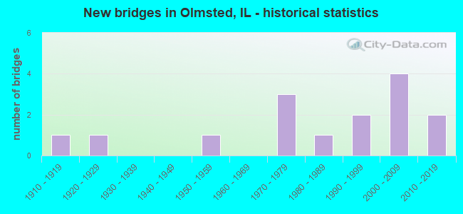
- New bridges - historical statistics
- 11910-1919
- 11920-1929
- 11950-1959
- 31970-1979
- 11980-1989
- 21990-1999
- 42000-2009
- 22010-2019


- Bridge Condition - Deck
- 27.3%Very good
- 27.3%Good
- 27.3%Satisfactory
- 18.2%Fair

- Bridge Condition - Superstructure
- 27.3%Very good
- 27.3%Good
- 27.3%Satisfactory
- 9.1%Fair
- 9.1%Poor

- Bridge Condition - Substructure
- 63.6%Very good
- 18.2%Good
- 9.1%Satisfactory
- 9.1%Poor

- Bridge Condition - Channel
- 20.0%Very good
- 13.3%Good
- 53.3%Satisfactory
- 13.3%Fair

- Bridge Condition - Culverts
- 75.0%Good
- 25.0%Fair
Find on map >> Show street view
Structure Number: 770029, Location: 0.4 MI W ILL 37 (Lat: 37.161628, Lng: -89.111575), Route carried "on" structure: County highway , Year Built: 1929, Status: Posted for load, Structure Length: 3.46m (11.35ft), Average Daily Traffic: 450 (year 2018), Truck Traffic: 11%, Average Future Daily Traffic: 77 (year 2032), Features Intersected: HODGES BAYOU, Facility Carried by Structure: TR 78A(OLD SBI 147
Minimum Vertical Clearance: 30+ m (98+ ft), Kilometerpoint: 0.628, Lanes on structure: 2, Owner: Town or Township Highway Agency, Approaching Roadway Width: 5.5m (18.0ft), Material/Design: Concrete, Design/Construction: Tee Beam, Number Of Spans In Main Unit: 3, Length of Maximum Span: 11.6m (38.1ft), Curb-To-Curb Width: 6.4m (21.0ft), Out-to-Out Width: 7.3m (24.0ft)
Condition: Deck: Fair, Superstructure: Poor, Substructure: Poor, Channel: Satisfactory, Operating Rating: 24.6 metric tons, Method Used To Determine Operating Rating: Load Factor (LF) rating reported by rating factor (RF) method using MS18 loading, Inventory Rating: 14.6 metric tons, Method Used To Determine Inventory Rating: Load Factor (LF) rating reported by rating factor (RF) method using MS18 loading, Structural Evaluation: Meets minimum limits, Deck Geometry: High priority of corrective action, Waterway Adequacy: Equal to present minimum criteria, Approach Roadway Alignment: Better than present minimum criteria, Bridge Posting: Required (Relationship of Operating Rating to Maximum Legal Load: > 39.9% below), Designated Inspection Frequency: Every 24 months, Inspection Date: December 2020, Deck Structure Type: Concrete Cast-file-Place, Wearing Surface/Protective System: Wearing Surface: Bituminous
Find on map >> Show street view
Structure Number: 77003, Location: IN OLMSTED (Lat: 37.180878, Lng: -89.093106), Route carried "on" structure: County highway , Year Built: 1954, Status: Open, Structure Length: 1.94m (6.36ft), Average Daily Traffic: 700 (year 2018), Truck Traffic: 3%, Average Future Daily Traffic: 818 (year 2032), Design Load: HS 15, Features Intersected: STREAM, Facility Carried by Structure: SBI 147 OFF ILL 37
Minimum Vertical Clearance: 30+ m (98+ ft), Kilometerpoint: 0.032, Lanes on structure: 2, Owner: State Highway Agency, Approaching Roadway Width: 6.1m (20.0ft), Skew: 2 degrees, Material/Design: Concrete continuous, Design/Construction: Slab, Number Of Spans In Main Unit: 2, Length of Maximum Span: 9.0m (29.5ft), Curb or Sidewalk Widths: Left: 0.6m (2.0ft), Right: 0.6m (2.0ft), Curb-To-Curb Width: 7.3m (24.0ft), Out-to-Out Width: 9.3m (30.5ft)
Condition: Deck: Fair, Superstructure: Fair, Substructure: Satisfactory, Channel: Satisfactory, Operating Rating: 50.9 metric tons, Method Used To Determine Operating Rating: Load Factor (LF) rating reported by rating factor (RF) method using MS18 loading, Inventory Rating: 30.8 metric tons, Method Used To Determine Inventory Rating: Load Factor (LF) rating reported by rating factor (RF) method using MS18 loading, Structural Evaluation: Somewhat better than minimum adequacy, Deck Geometry: Meets minimum limits, Waterway Adequacy: Equal to present desirable criteria, Approach Roadway Alignment: Equal to present desirable criteria, Length Of Structure Improvement: 1.95m (6.40ft), Designated Inspection Frequency: Every 24 months, Inspection Date: July 2020, Bridge Improvement Cost: $150,000, Roadway Improvement Cost: $15,000, Total Project Cost: $225,000, Deck Structure Type: Concrete Cast-file-Place, Wearing Surface/Protective System: Wearing Surface: Epoxy Overlay
Find on map >> Show street view
Structure Number: 772003, Location: 1 MI N OLMSTED (Lat: 37.200739, Lng: -89.077142), Route carried "on" structure: State highway 37, Year Built: 1916, Year Reconstructed: 1955, Status: Open, Structure Length: 1.07m (3.51ft), Average Daily Traffic: 1,200 (year 2021), Truck Traffic: 21%, Average Future Daily Traffic: 1,228 (year 2032), Design Load: HS 20, Features Intersected: STREAM
Minimum Vertical Clearance: 30+ m (98+ ft), Kilometerpoint: 23.029, Lanes on structure: 2, Base Highway Network: Yes, Owner: State Highway Agency, Approaching Roadway Width: 7.3m (24.0ft), Skew: 4 degrees, Material/Design: Concrete continuous, Design/Construction: Culvert, Number Of Spans In Main Unit: 2, Length of Maximum Span: 5.2m (17.1ft), Curb-To-Curb Width: 7.3m (24.0ft), Out-to-Out Width: 14.4m (47.2ft)
Condition: Channel: Fair, Culverts: Fair, Operating Rating: 56.4 metric tons, Method Used To Determine Operating Rating: Load Factor (LF) rating reported by rating factor (RF) method using MS18 loading, Inventory Rating: 33.7 metric tons, Method Used To Determine Inventory Rating: Load Factor (LF) rating reported by rating factor (RF) method using MS18 loading, Structural Evaluation: Somewhat better than minimum adequacy, Deck Geometry: Meets minimum limits, Waterway Adequacy: Better than present minimum criteria, Approach Roadway Alignment: Equal to present desirable criteria, Length Of Structure Improvement: 1.22m (4.00ft), Designated Inspection Frequency: Every 24 months, Inspection Date: January 2021, Bridge Improvement Cost: $80,000, Roadway Improvement Cost: $15,000, Total Project Cost: $95,000
Find on map >> Show street view
Structure Number: 77201, Location: 0.3 MI N OLMSTD SPUR (Lat: 37.184364, Lng: -89.091106), Route carried "on" structure: State highway 37, Year Built: 2004, Status: Open, Structure Length: 1.00m (3.28ft), Average Daily Traffic: 1,350 (year 2021), Truck Traffic: 22%, Average Future Daily Traffic: 1,330 (year 2032), Design Load: HS 20, Features Intersected: STREAM
Minimum Vertical Clearance: 30+ m (98+ ft), Kilometerpoint: 20.889, Lanes on structure: 2, Base Highway Network: Yes, Owner: State Highway Agency, Approaching Roadway Width: 7.9m (25.9ft), Skew: 2 degrees, Material/Design: Concrete continuous, Design/Construction: Culvert, Number Of Spans In Main Unit: 3, Length of Maximum Span: 3.2m (10.5ft)
Condition: Channel: Fair, Culverts: Good, Operating Rating: 71.3 metric tons, Method Used To Determine Operating Rating: Load Factor (LF) rating reported by rating factor (RF) method using MS18 loading, Inventory Rating: 42.8 metric tons, Method Used To Determine Inventory Rating: Load Factor (LF) rating reported by rating factor (RF) method using MS18 loading, Structural Evaluation: Better than present minimum criteria, Waterway Adequacy: Superior to present desirable criteria, Approach Roadway Alignment: Equal to present desirable criteria, Designated Inspection Frequency: Every 48 months, Inspection Date: January 2021
Find on map >> Show street view
Structure Number: 772011, Location: 0.3 MI S OLMSTD SPUR (Lat: 37.177547, Lng: -89.095831), Route carried "on" structure: State highway 37, Year Built: 2004, Status: Open, Structure Length: 1.02m (3.35ft), Average Daily Traffic: 1,400 (year 2021), Truck Traffic: 21%, Average Future Daily Traffic: 1,688 (year 2032), Design Load: HS 20, Features Intersected: STREAM
Minimum Vertical Clearance: 30+ m (98+ ft), Kilometerpoint: 20.020, Lanes on structure: 2, Base Highway Network: Yes, Owner: State Highway Agency, Approaching Roadway Width: 13.4m (44.0ft), Material/Design: Concrete continuous, Design/Construction: Culvert, Number Of Spans In Main Unit: 3, Length of Maximum Span: 3.4m (11.2ft), Curb-To-Curb Width: 13.4m (44.0ft), Out-to-Out Width: 13.6m (44.6ft)
Condition: Channel: Satisfactory, Culverts: Good, Operating Rating: 62.2 metric tons, Method Used To Determine Operating Rating: Load Factor (LF) rating reported by rating factor (RF) method using MS18 loading, Inventory Rating: 37.3 metric tons, Method Used To Determine Inventory Rating: Load Factor (LF) rating reported by rating factor (RF) method using MS18 loading, Structural Evaluation: Better than present minimum criteria, Deck Geometry: Equal to present desirable criteria, Waterway Adequacy: Superior to present desirable criteria, Approach Roadway Alignment: Equal to present desirable criteria, Designated Inspection Frequency: Every 48 months, Inspection Date: January 2021
Find on map >> Show street view
Structure Number: 77306, Location: 1 MI.S.W. OF OLMSTED (Lat: 37.173317, Lng: -89.121711), Route carried "on" structure: County highway , Year Built: 1978, Status: Open, Structure Length: 1.77m (5.81ft), Average Daily Traffic: 150 (year 2018), Truck Traffic: 18%, Average Future Daily Traffic: 256 (year 2032), Design Load: HS 20, Features Intersected: HODGES CREEK, Facility Carried by Structure: TR 107
Minimum Vertical Clearance: 30+ m (98+ ft), Kilometerpoint: 8.449, Lanes on structure: 2, Owner: Town or Township Highway Agency, Approaching Roadway Width: 5.5m (18.0ft), Material/Design: Prestressed concrete, Design/Construction: Box Beam or Girders - Multiple, Number Of Spans In Main Unit: 1, Length of Maximum Span: 17.1m (56.1ft), Curb-To-Curb Width: 7.5m (24.6ft), Out-to-Out Width: 7.5m (24.6ft)
Condition: Deck: Good, Superstructure: Good, Substructure: Very good, Channel: Satisfactory, Operating Rating: 44.1 metric tons, Method Used To Determine Operating Rating: Assigned rating based on Load Factor Design (LFD) reported by rating factor (RF) using MS18 loading, Inventory Rating: 32.4 metric tons, Method Used To Determine Inventory Rating: Assigned rating based on Load Factor Design (LFD) reported by rating factor (RF) using MS18 loading, Structural Evaluation: Better than present minimum criteria, Deck Geometry: Somewhat better than minimum adequacy, Waterway Adequacy: Equal to present minimum criteria, Approach Roadway Alignment: Equal to present minimum criteria, Designated Inspection Frequency: Every 48 months, Inspection Date: January 2019, Deck Structure Type: Concrete Precast Panels, Wearing Surface/Protective System: Wearing Surface: Other, Membrane: Other, Deck Protection: Other
Find on map >> Show street view
Structure Number: 773063, Location: 1 MI SW OLMSTED (Lat: 37.176142, Lng: -89.123211), Route carried "on" structure: County highway , Year Built: 1977, Status: Open, Structure Length: 1.77m (5.81ft), Average Daily Traffic: 50 (year 2018), Truck Traffic: 30%, Average Future Daily Traffic: 51 (year 2032), Design Load: HS 20+Mod, Features Intersected: HODGES CREEK, Facility Carried by Structure: TR 80
Minimum Vertical Clearance: 30+ m (98+ ft), Kilometerpoint: 3.524, Lanes on structure: 2, Owner: Town or Township Highway Agency, Approaching Roadway Width: 4.9m (16.1ft), Skew: 2 degrees, Material/Design: Prestressed concrete, Design/Construction: Box Beam or Girders - Multiple, Number Of Spans In Main Unit: 1, Length of Maximum Span: 16.9m (55.4ft), Curb-To-Curb Width: 6.3m (20.7ft), Out-to-Out Width: 6.5m (21.3ft)
Condition: Deck: Good, Superstructure: Good, Substructure: Good, Channel: Satisfactory, Operating Rating: 40.5 metric tons, Method Used To Determine Operating Rating: Field evaluation and documented engineering judgment, Inventory Rating: 24.3 metric tons, Method Used To Determine Inventory Rating: Field evaluation and documented engineering judgment, Structural Evaluation: Equal to present minimum criteria, Deck Geometry: Somewhat better than minimum adequacy, Waterway Adequacy: Equal to present minimum criteria, Approach Roadway Alignment: Equal to present desirable criteria, Designated Inspection Frequency: Every 24 months, Inspection Date: December 2020, Deck Structure Type: Concrete Precast Panels, Wearing Surface/Protective System: Wearing Surface: Gravel
Find on map >> Show street view
Structure Number: 773107, Location: OLMSTED (Lat: 37.186919, Lng: -89.085794), Route carried "on" structure: City street , Year Built: 1988, Status: Open, Structure Length: 1.88m (6.17ft), Average Daily Traffic: 375 (year 2018), Truck Traffic: 22%, Average Future Daily Traffic: 384 (year 2032), Design Load: HS 20, Features Intersected: TRIB TO HODGES CREEK, Facility Carried by Structure: CS 6030
Minimum Vertical Clearance: 30+ m (98+ ft), Kilometerpoint: 0.354, Lanes on structure: 2, Owner: City or Municipal Highway Agency, Approaching Roadway Width: 6.1m (20.0ft), Skew: 1 degrees, Material/Design: Prestressed concrete, Design/Construction: Box Beam or Girders - Multiple, Number Of Spans In Main Unit: 1, Length of Maximum Span: 18.0m (59.1ft), Curb-To-Curb Width: 7.4m (24.3ft), Out-to-Out Width: 7.4m (24.3ft)
Condition: Deck: Satisfactory, Superstructure: Satisfactory, Substructure: Very good, Channel: Good, Operating Rating: 55.7 metric tons, Method Used To Determine Operating Rating: Load Factor (LF) rating reported by rating factor (RF) method using MS18 loading, Inventory Rating: 33.4 metric tons, Method Used To Determine Inventory Rating: Load Factor (LF) rating reported by rating factor (RF) method using MS18 loading, Structural Evaluation: Equal to present minimum criteria, Deck Geometry: Somewhat better than minimum adequacy, Waterway Adequacy: Better than present minimum criteria, Approach Roadway Alignment: Equal to present desirable criteria, Designated Inspection Frequency: Every 24 months, Inspection Date: January 2021, Deck Structure Type: Concrete Precast Panels, Wearing Surface/Protective System: Wearing Surface: Gravel
Find on map >> Show street view
Structure Number: 773116, Location: 3.5 MI E PULASKI (Lat: 37.204672, Lng: -89.138019), Route carried "on" structure: County highway , Year Built: 1992, Status: Open, Structure Length: 1.57m (5.15ft), Average Daily Traffic: 175 (year 2018), Truck Traffic: 19%, Average Future Daily Traffic: 153 (year 2032), Design Load: HS 20, Features Intersected: HODGES BAYOU, Facility Carried by Structure: TR 95A
Minimum Vertical Clearance: 30+ m (98+ ft), Kilometerpoint: 11.410, Lanes on structure: 2, Owner: Town or Township Highway Agency, Approaching Roadway Width: 6.1m (20.0ft), Material/Design: Prestressed concrete, Design/Construction: Box Beam or Girders - Multiple, Number Of Spans In Main Unit: 1, Length of Maximum Span: 14.9m (48.9ft), Curb-To-Curb Width: 7.4m (24.3ft), Out-to-Out Width: 7.4m (24.3ft)
Condition: Deck: Satisfactory, Superstructure: Satisfactory, Substructure: Good, Channel: Satisfactory, Operating Rating: 64.5 metric tons, Method Used To Determine Operating Rating: Load Factor (LF) rating reported by rating factor (RF) method using MS18 loading, Inventory Rating: 38.6 metric tons, Method Used To Determine Inventory Rating: Load Factor (LF) rating reported by rating factor (RF) method using MS18 loading, Structural Evaluation: Equal to present minimum criteria, Deck Geometry: Somewhat better than minimum adequacy, Waterway Adequacy: Superior to present desirable criteria, Approach Roadway Alignment: Equal to present desirable criteria, Designated Inspection Frequency: Every 24 months, Inspection Date: January 2021, Deck Structure Type: Concrete Precast Panels, Wearing Surface/Protective System: Wearing Surface: Gravel
Find on map >> Show street view
Structure Number: 773124, Location: 1 MI E MERIDIAN RD (Lat: 37.151386, Lng: -89.144311), Route carried "on" structure: County highway , Year Built: 1999, Status: Open, Structure Length: 1.26m (4.13ft), Average Daily Traffic: 100 (year 2018), Truck Traffic: 14%, Average Future Daily Traffic: 77 (year 2032), Design Load: HS 20, Features Intersected: TRIB TO HESS BAYOU, Facility Carried by Structure: TR 115
Minimum Vertical Clearance: 30+ m (98+ ft), Kilometerpoint: 2.156, Lanes on structure: 2, Owner: Town or Township Highway Agency, Approaching Roadway Width: 6.7m (22.0ft), Skew: 1 degrees, Material/Design: Prestressed concrete, Design/Construction: Box Beam or Girders - Multiple, Number Of Spans In Main Unit: 1, Length of Maximum Span: 11.9m (39.0ft), Curb-To-Curb Width: 7.4m (24.3ft), Out-to-Out Width: 7.4m (24.3ft)
Condition: Deck: Good, Superstructure: Good, Substructure: Very good, Channel: Satisfactory, Operating Rating: 63.2 metric tons, Method Used To Determine Operating Rating: Load Factor (LF) rating reported by rating factor (RF) method using MS18 loading, Inventory Rating: 37.6 metric tons, Method Used To Determine Inventory Rating: Load Factor (LF) rating reported by rating factor (RF) method using MS18 loading, Structural Evaluation: Better than present minimum criteria, Deck Geometry: Equal to present minimum criteria, Waterway Adequacy: Superior to present desirable criteria, Approach Roadway Alignment: Equal to present desirable criteria, Designated Inspection Frequency: Every 48 months, Inspection Date: January 2021, Deck Structure Type: Concrete Precast Panels, Wearing Surface/Protective System: Wearing Surface: Gravel
Find on map >> Show street view
Structure Number: 77313, Location: 2 MI W OLMSTED (Lat: 37.172767, Lng: -89.122531), Route carried "on" structure: County highway , Year Built: 2003, Status: Open, Structure Length: 1.11m (3.64ft), Average Daily Traffic: 25 (year 2018), Truck Traffic: 8%, Average Future Daily Traffic: 77 (year 2032), Design Load: HS 20, Features Intersected: HODGES CR TRIB, Facility Carried by Structure: TR 78
Minimum Vertical Clearance: 30+ m (98+ ft), Kilometerpoint: 0.064, Lanes on structure: 2, Owner: Town or Township Highway Agency, Approaching Roadway Width: 5.5m (18.0ft), Material/Design: Prestressed concrete, Design/Construction: Box Beam or Girders - Multiple, Number Of Spans In Main Unit: 1, Length of Maximum Span: 10.4m (34.1ft), Curb-To-Curb Width: 7.4m (24.3ft), Out-to-Out Width: 7.4m (24.3ft)
Condition: Deck: Satisfactory, Superstructure: Satisfactory, Substructure: Very good, Channel: Very good, Operating Rating: 44.1 metric tons, Method Used To Determine Operating Rating: Assigned rating based on Load Factor Design (LFD) reported by rating factor (RF) using MS18 loading, Inventory Rating: 32.4 metric tons, Method Used To Determine Inventory Rating: Assigned rating based on Load Factor Design (LFD) reported by rating factor (RF) using MS18 loading, Structural Evaluation: Equal to present minimum criteria, Deck Geometry: Equal to present minimum criteria, Waterway Adequacy: Equal to present minimum criteria, Approach Roadway Alignment: Equal to present desirable criteria, Designated Inspection Frequency: Every 24 months, Inspection Date: January 2021, Deck Structure Type: Concrete Precast Panels
Find on map >> Show street view
Structure Number: 773131, Location: 3.0 MI SW OF OLMSTED (Lat: 37.143825, Lng: -89.144400), Route carried "on" structure: County highway , Year Built: 2003, Status: Open, Structure Length: 1.12m (3.67ft), Average Daily Traffic: 100 (year 2018), Truck Traffic: 6%, Average Future Daily Traffic: 102 (year 2032), Design Load: HS 20, Features Intersected: TRIB HESS BAYOU, Facility Carried by Structure: TR 117
Minimum Vertical Clearance: 30+ m (98+ ft), Kilometerpoint: 2.366, Lanes on structure: 2, Owner: Town or Township Highway Agency, Approaching Roadway Width: 6.7m (22.0ft), Skew: 1 degrees, Material/Design: Prestressed concrete, Design/Construction: Box Beam or Girders - Multiple, Number Of Spans In Main Unit: 1, Length of Maximum Span: 10.4m (34.1ft), Curb-To-Curb Width: 7.3m (24.0ft), Out-to-Out Width: 7.3m (24.0ft)
Condition: Deck: Very good, Superstructure: Very good, Substructure: Very good, Channel: Good, Operating Rating: 44.1 metric tons, Method Used To Determine Operating Rating: Assigned rating based on Load Factor Design (LFD) reported by rating factor (RF) using MS18 loading, Inventory Rating: 32.4 metric tons, Method Used To Determine Inventory Rating: Assigned rating based on Load Factor Design (LFD) reported by rating factor (RF) using MS18 loading, Structural Evaluation: Equal to present desirable criteria, Deck Geometry: Equal to present minimum criteria, Waterway Adequacy: Equal to present desirable criteria, Approach Roadway Alignment: Equal to present desirable criteria, Designated Inspection Frequency: Every 48 months, Inspection Date: January 2019, Deck Structure Type: Concrete Precast Panels
Find on map >> Show street view
Structure Number: 773142, Location: 1 Mi E of I-57 (Lat: 37.190172, Lng: -89.144583), Route carried "on" structure: County highway , Year Built: 2018, Status: Open, Structure Length: 1.41m (4.63ft), Average Daily Traffic: 25 (year 2018), Average Future Daily Traffic: 75 (year 2039), Design Load: HS 25 or greater, Features Intersected: Trib Hodges Creek, Facility Carried by Structure: TR-99 (PryorTownRd
Minimum Vertical Clearance: 30+ m (98+ ft), Kilometerpoint: 2.269, Lanes on structure: 2, Owner: Town or Township Highway Agency, Approaching Roadway Width: 6.7m (22.0ft), Material/Design: Prestressed concrete, Design/Construction: Box Beam or Girders - Multiple, Number Of Spans In Main Unit: 1, Length of Maximum Span: 13.2m (43.3ft), Curb-To-Curb Width: 7.3m (24.0ft), Out-to-Out Width: 7.3m (24.0ft)
Condition: Deck: Very good, Superstructure: Very good, Substructure: Very good, Channel: Very good, Operating Rating: 42.1 metric tons, Method Used To Determine Operating Rating: Assigned ratings based on Load and Resistance Factor Design (LRFD) reported by rating factor (RF) using HL93 loadings, Inventory Rating: 32.4 metric tons, Method Used To Determine Inventory Rating: Assigned ratings based on Load and Resistance Factor Design (LRFD) reported by rating factor (RF) using HL93 loadings, Structural Evaluation: Equal to present desirable criteria, Deck Geometry: Equal to present minimum criteria, Waterway Adequacy: Equal to present desirable criteria, Approach Roadway Alignment: Equal to present desirable criteria, Designated Inspection Frequency: Every 48 months, Inspection Date: July 2020, Deck Structure Type: Concrete Precast Panels
Find on map >> Show street view
Structure Number: 773144, Location: 0.70 MI WEST IL 37 (Lat: 37.171858, Lng: -89.113436), Route carried "on" structure: County highway , Year Built: 2016, Status: Open, Structure Length: 1.53m (5.02ft), Average Daily Traffic: 150 (year 2018), Truck Traffic: 18%, Average Future Daily Traffic: 256 (year 2032), Design Load: HS 25 or greater, Features Intersected: TRIB TO HODGES CREEK, Facility Carried by Structure: OLMSTED RD
Minimum Vertical Clearance: 30+ m (98+ ft), Kilometerpoint: 9.205, Lanes on structure: 2, Owner: Town or Township Highway Agency, Approaching Roadway Width: 6.1m (20.0ft), Material/Design: Prestressed concrete, Design/Construction: Box Beam or Girders - Multiple, Number Of Spans In Main Unit: 1, Length of Maximum Span: 14.5m (47.6ft), Curb-To-Curb Width: 7.4m (24.3ft), Out-to-Out Width: 7.4m (24.3ft)
Condition: Deck: Very good, Superstructure: Very good, Substructure: Very good, Channel: Very good, Operating Rating: 42.1 metric tons, Method Used To Determine Operating Rating: Assigned ratings based on Load and Resistance Factor Design (LRFD) reported by rating factor (RF) using HL93 loadings, Inventory Rating: 32.4 metric tons, Method Used To Determine Inventory Rating: Assigned ratings based on Load and Resistance Factor Design (LRFD) reported by rating factor (RF) using HL93 loadings, Structural Evaluation: Equal to present desirable criteria, Deck Geometry: Somewhat better than minimum adequacy, Waterway Adequacy: Equal to present desirable criteria, Approach Roadway Alignment: Equal to present minimum criteria, Designated Inspection Frequency: Every 48 months, Inspection Date: September 2018, Deck Structure Type: Concrete Precast Panels
Find on map >> Show street view
Structure Number: 775003, Location: 3/4 MILE NW OLMSTED (Lat: 37.195672, Lng: -89.092653), Route carried "on" structure: County highway , Year Built: 1975, Status: Open, Structure Length: 0.88m (2.89ft), Average Daily Traffic: 600 (year 2018), Truck Traffic: 12%, Average Future Daily Traffic: 512 (year 2032), Design Load: HS 20, Features Intersected: CREEK, Facility Carried by Structure: FAS 1920
Minimum Vertical Clearance: 30+ m (98+ ft), Kilometerpoint: 11.651, Lanes on structure: 2, Owner: County Highway Agency, Approaching Roadway Width: 10.4m (34.1ft), Skew: 3 degrees, Material/Design: Concrete continuous, Design/Construction: Culvert, Number Of Spans In Main Unit: 2, Length of Maximum Span: 4.3m (14.1ft)
Condition: Channel: Satisfactory, Culverts: Good, Operating Rating: 63.2 metric tons, Method Used To Determine Operating Rating: Load Factor (LF) rating reported by rating factor (RF) method using MS18 loading, Inventory Rating: 37.9 metric tons, Method Used To Determine Inventory Rating: Load Factor (LF) rating reported by rating factor (RF) method using MS18 loading, Structural Evaluation: Better than present minimum criteria, Waterway Adequacy: Superior to present desirable criteria, Approach Roadway Alignment: Equal to present desirable criteria, Designated Inspection Frequency: Every 48 months, Inspection Date: January 2019