Bridge Statistics for Old Mill Creek, Illinois (IL)
Condition, Traffic, Stress, Structural Evaluation, Project Costs
- National Bridge Inventory (NBI) Statistics
- 10Number of bridges
- 118ft / 35.9mTotal length
- 256,300Total average daily traffic
- 19,876Total average daily truck traffic
- National Bridge Inventory (NBI) Registered Bridges for Old Mill Creek
- No street view available for this location
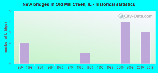
- New bridges - historical statistics
- 21950-1959
- 11980-1989
- 42000-2009
- 32010-2019


- Bridge Condition - Deck
- 50.0%Very good
- 16.7%Good
- 33.3%Satisfactory

- Bridge Condition - Superstructure
- 57.1%Very good
- 14.3%Good
- 28.6%Satisfactory

- Bridge Condition - Substructure
- 42.9%Very good
- 57.1%Good

- Bridge Condition - Channel
- 33.3%Very good
- 16.7%Good
- 50.0%Satisfactory
Find on map >> Show street view
Structure Number: 490535, Location: 0.75 M W US 41 (Lat: 42.465586, Lng: -87.964139), Route carried "on" structure: State highway 173, Year Built: 2015, Status: Open, Structure Length: 7.71m (25.30ft), Average Daily Traffic: 17,200 (year 2021), Truck Traffic: 7%, Average Future Daily Traffic: 17,252 (year 2032), Design Load: HS 25 or greater, Features Intersected: I- 94 TRI-STATE
Minimum Vertical Clearance: 30+ m (98+ ft), Kilometerpoint: 94.772, Lanes on structure: 4, Lanes under structure: 6, Base Highway Network: Yes, Owner: State Highway Agency, Approaching Roadway Width: 24.4m (80.1ft), Skew: 31 degrees, Material/Design: Prestressed concrete continuous, Design/Construction: Stringer/Multi-beam, Number Of Spans In Main Unit: 4, Length of Maximum Span: 38.1m (125.0ft), Curb or Sidewalk Widths: Left: 4.3m (14.1ft), Right: 2.1m (6.9ft), Curb-To-Curb Width: 24.4m (80.1ft), Out-to-Out Width: 38.8m (127.3ft)
Condition: Deck: Good, Superstructure: Very good, Substructure: Good, Operating Rating: 70.0 metric tons, Method Used To Determine Operating Rating: Load Factor (LF) rating reported by rating factor (RF) method using MS18 loading, Inventory Rating: 42.1 metric tons, Method Used To Determine Inventory Rating: Load Factor (LF) rating reported by rating factor (RF) method using MS18 loading, Structural Evaluation: Better than present minimum criteria, Deck Geometry: Superior to present desirable criteria, Approach Roadway Alignment: Equal to present desirable criteria, Designated Inspection Frequency: Every 24 months, Inspection Date: May 2019, Deck Structure Type: Concrete Cast-file-Place, Wearing Surface/Protective System: Deck Protection: Epoxy Coated Reinforcing
Find on map >> Show street view
Structure Number: 49061, Location: 1M N of Sand Lake Rd (Lat: 42.420386, Lng: -88.005431), Route carried "on" structure: Other road , Year Built: 2019, Status: Open, Structure Length: 1.28m (4.20ft), Average Daily Traffic: 6,000 (year 2019), Average Future Daily Traffic: 6,780 (year 2038), Design Load: HS 25 or greater, Features Intersected: MILBURN CR, Facility Carried by Structure: US 45
Minimum Vertical Clearance: 30+ m (98+ ft), Kilometerpoint: 5.198, Lanes on structure: 4, Owner: State Highway Agency, Approaching Roadway Width: 14.6m (47.9ft), Skew: 30 degrees, Material/Design: Concrete, Design/Construction: Frame, Number Of Spans In Main Unit: 1, Length of Maximum Span: 0.0m, Curb or Sidewalk Widths: Left: 5.2m (17.1ft), Right: 3.0m (9.8ft), Curb-To-Curb Width: 14.6m (47.9ft), Out-to-Out Width: 31.7m (104.0ft)
Condition: Superstructure: Very good, Substructure: Very good, Channel: Good, Operating Rating: 45.7 metric tons, Method Used To Determine Operating Rating: Load and Resistance Factor Rating (LRFR) rating reported by rating factor(RF) method using HL-93 loadings, Inventory Rating: 35.3 metric tons, Method Used To Determine Inventory Rating: Load and Resistance Factor Rating (LRFR) rating reported by rating factor(RF) method using HL-93 loadings, Structural Evaluation: Equal to present desirable criteria, Deck Geometry: High priority of replacement, Waterway Adequacy: Superior to present desirable criteria, Approach Roadway Alignment: Equal to present desirable criteria, Designated Inspection Frequency: Every 48 months, Inspection Date: Febuary 2022, Deck Structure Type: Other
Find on map >> Show street view
Structure Number: 493072, Location: 2M N OF IL132 (Lat: 42.415356, Lng: -87.969061), Route carried "on" structure: Other road , Year Built: 2006, Status: Open, Structure Length: 2.35m (7.71ft), Average Daily Traffic: 11,800 (year 2019), Truck Traffic: 4%, Average Future Daily Traffic: 12,688 (year 2032), Design Load: HS 20, Features Intersected: MILL CREEK, Facility Carried by Structure: HUNT CLUB RD
Minimum Vertical Clearance: 30+ m (98+ ft), Kilometerpoint: 8.948, Lanes on structure: 2, Base Highway Network: Yes, Owner: County Highway Agency, Approaching Roadway Width: 12.2m (40.0ft), Material/Design: Steel, Design/Construction: Stringer/Multi-beam, Number Of Spans In Main Unit: 1, Length of Maximum Span: 21.9m (71.9ft), Curb-To-Curb Width: 12.2m (40.0ft), Out-to-Out Width: 13.1m (43.0ft)
Condition: Deck: Very good, Superstructure: Very good, Substructure: Very good, Channel: Very good, Operating Rating: 44.1 metric tons, Method Used To Determine Operating Rating: Assigned rating based on Load Factor Design (LFD) reported by rating factor (RF) using MS18 loading, Inventory Rating: 32.4 metric tons, Method Used To Determine Inventory Rating: Assigned rating based on Load Factor Design (LFD) reported by rating factor (RF) using MS18 loading, Structural Evaluation: Equal to present desirable criteria, Deck Geometry: Somewhat better than minimum adequacy, Waterway Adequacy: Superior to present desirable criteria, Approach Roadway Alignment: Equal to present desirable criteria, Designated Inspection Frequency: Every 48 months, Inspection Date: April 2020, Deck Structure Type: Concrete Cast-file-Place, Wearing Surface/Protective System: Deck Protection: Epoxy Coated Reinforcing
Find on map >> Show street view
Structure Number: 493075, Location: 0.4 MI E OF US45 (Lat: 42.424739, Lng: -87.997331), Route carried "on" structure: Other road , Year Built: 2007, Status: Open, Structure Length: 3.58m (11.75ft), Average Daily Traffic: 9,900 (year 2019), Truck Traffic: 4%, Average Future Daily Traffic: 9,461 (year 2032), Design Load: HS 20, Features Intersected: NORTH MILL CREEK, Facility Carried by Structure: MILLBURN ROAD
Minimum Vertical Clearance: 30+ m (98+ ft), Kilometerpoint: 1.030, Lanes on structure: 2, Base Highway Network: Yes, Owner: County Highway Agency, Approaching Roadway Width: 13.4m (44.0ft), Skew: 8 degrees, Material/Design: Concrete, Design/Construction: Slab, Number Of Spans In Main Unit: 3, Length of Maximum Span: 13.1m (43.0ft), Curb or Sidewalk Widths: Left: 4.3m (14.1ft), Right: 0.0m, Curb-To-Curb Width: 12.6m (41.3ft), Out-to-Out Width: 18.1m (59.4ft)
Condition: Deck: Very good, Superstructure: Very good, Substructure: Very good, Channel: Very good, Operating Rating: 44.1 metric tons, Method Used To Determine Operating Rating: Assigned rating based on Load Factor Design (LFD) reported by rating factor (RF) using MS18 loading, Inventory Rating: 32.4 metric tons, Method Used To Determine Inventory Rating: Assigned rating based on Load Factor Design (LFD) reported by rating factor (RF) using MS18 loading, Structural Evaluation: Equal to present desirable criteria, Deck Geometry: Somewhat better than minimum adequacy, Waterway Adequacy: Superior to present desirable criteria, Approach Roadway Alignment: Equal to present desirable criteria, Designated Inspection Frequency: Every 48 months, Inspection Date: April 2020, Deck Structure Type: Concrete Cast-file-Place, Wearing Surface/Protective System: Deck Protection: Epoxy Coated Reinforcing
Find on map >> Show street view
Structure Number: 495004, Location: 1 MI N OF ILL 132 (Lat: 42.398833, Lng: -87.980836), Route carried "on" structure: Other road , Year Built: 1983, Status: Temporarily open, Structure Length: 0.99m (3.25ft), Average Daily Traffic: 11,600 (year 2019), Truck Traffic: 3%, Average Future Daily Traffic: 12,354 (year 2032), Design Load: HS 20+Mod, Features Intersected: MILL CREEK, Facility Carried by Structure: STEARNS SCHOOL RD.
Minimum Vertical Clearance: 30+ m (98+ ft), Kilometerpoint: 0.579, Lanes on structure: 2, Base Highway Network: Yes, Owner: County Highway Agency, Approaching Roadway Width: 11.8m (38.7ft), Material/Design: Steel, Design/Construction: Culvert, Number Of Spans In Main Unit: 3, Length of Maximum Span: 4.3m (14.1ft)
Condition: Channel: Satisfactory, Culverts: Good, Structural Evaluation: High priority of corrective action, Waterway Adequacy: Equal to present desirable criteria, Approach Roadway Alignment: Equal to present desirable criteria, Designated Inspection Frequency: Every 24 months, Inspection Date: January 2022
Find on map >> Show street view
Structure Number: 496001, Location: .6M W OF IL41 (Lat: 42.429036, Lng: -87.949661), Route carried "on" structure: Other road , Year Built: 2006, Status: Open, Structure Length: 12.04m (39.50ft), Average Daily Traffic: 10,500 (year 2019), Truck Traffic: 4%, Average Future Daily Traffic: 10,796 (year 2032), Design Load: HS 20, Features Intersected: I-94, Facility Carried by Structure: WADSWORTH RD
Minimum Vertical Clearance: 30+ m (98+ ft), Kilometerpoint: 1.851, Lanes on structure: 2, Lanes under structure: 10, Base Highway Network: Yes, Owner: County Highway Agency, Approaching Roadway Width: 7.3m (24.0ft), Material/Design: Prestressed concrete continuous, Design/Construction: Stringer/Multi-beam, Number Of Spans In Main Unit: 2, Length of Maximum Span: 56.7m (186.0ft), Curb or Sidewalk Widths: Left: 0.0m, Right: 4.0m (13.1ft), Curb-To-Curb Width: 7.3m (24.0ft), Out-to-Out Width: 16.1m (52.8ft)
Condition: Deck: Very good, Superstructure: Good, Substructure: Good, Operating Rating: 59.0 metric tons, Method Used To Determine Operating Rating: Load Factor (LF) rating reported by rating factor (RF) method using MS18 loading, Inventory Rating: 35.3 metric tons, Method Used To Determine Inventory Rating: Load Factor (LF) rating reported by rating factor (RF) method using MS18 loading, Structural Evaluation: Better than present minimum criteria, Deck Geometry: High priority of replacement, Underclear: Meets minimum limits, Approach Roadway Alignment: Equal to present desirable criteria, Designated Inspection Frequency: Every 24 months, Inspection Date: April 2020, Deck Structure Type: Concrete Cast-file-Place, Wearing Surface/Protective System: Wearing Surface: Bituminous, Membrane: Built-up
Find on map >> Show street view
Structure Number: 499917, Location: I-94 205 M N ILL-132 (Lat: 42.417794, Lng: -87.947881), Route carried "on" structure: Interstate 94, Year Built: 1958, Status: Open, Structure Length: 3.96m (12.99ft), Average Daily Traffic: 31,550 (year 2020), Truck Traffic: 9%, Average Future Daily Traffic: 33,501 (year 2032), Design Load: HS 20, Features Intersected: MILL CREEK
Minimum Vertical Clearance: 30+ m (98+ ft), Kilometerpoint: 9.527, Lanes on structure: 2, Base Highway Network: Yes, Toll: On toll road, Owner: State Toll Authority, Approaching Roadway Width: 12.2m (40.0ft), Skew: 1 degrees, Material/Design: Prestressed concrete, Design/Construction: Stringer/Multi-beam, Number Of Spans In Main Unit: 3, Length of Maximum Span: 12.8m (42.0ft), Curb-To-Curb Width: 10.5m (34.4ft), Out-to-Out Width: 12.0m (39.4ft)
Condition: Deck: Satisfactory, Superstructure: Satisfactory, Substructure: Good, Channel: Satisfactory, Operating Rating: 66.1 metric tons, Method Used To Determine Operating Rating: Load Factor (LF) rating reported by rating factor (RF) method using MS18 loading, Inventory Rating: 39.5 metric tons, Method Used To Determine Inventory Rating: Load Factor (LF) rating reported by rating factor (RF) method using MS18 loading, Structural Evaluation: Equal to present minimum criteria, Deck Geometry: Meets minimum limits, Waterway Adequacy: Superior to present desirable criteria, Approach Roadway Alignment: Equal to present desirable criteria, Designated Inspection Frequency: Every 24 months, Underwater Inspection Frequency: Every 60 months, Inspection Date: May 2020, Underwater Inspection Date: April 2018, Deck Structure Type: Concrete Cast-file-Place, Wearing Surface/Protective System: Wearing Surface: Bituminous, Membrane: Built-up
Find on map >> Show street view
Structure Number: 499918, Location: I-94 2.5M N ILL 132 (Lat: 42.417647, Lng: -87.947889), Route carried "on" structure: Interstate 94, Year Built: 1958, Status: Open, Structure Length: 3.96m (12.99ft), Average Daily Traffic: 31,550 (year 2020), Truck Traffic: 9%, Average Future Daily Traffic: 33,501 (year 2032), Design Load: HS 20, Features Intersected: MILL CREEK
Minimum Vertical Clearance: 30+ m (98+ ft), Kilometerpoint: 9.543, Lanes on structure: 2, Base Highway Network: Yes, Toll: On toll road, Owner: State Toll Authority, Approaching Roadway Width: 12.2m (40.0ft), Skew: 1 degrees, Material/Design: Prestressed concrete, Design/Construction: Stringer/Multi-beam, Number Of Spans In Main Unit: 3, Length of Maximum Span: 12.8m (42.0ft), Curb-To-Curb Width: 10.5m (34.4ft), Out-to-Out Width: 12.0m (39.4ft)
Condition: Deck: Satisfactory, Superstructure: Satisfactory, Substructure: Good, Channel: Satisfactory, Operating Rating: 69.3 metric tons, Method Used To Determine Operating Rating: Load Factor (LF) rating reported by rating factor (RF) method using MS18 loading, Inventory Rating: 41.5 metric tons, Method Used To Determine Inventory Rating: Load Factor (LF) rating reported by rating factor (RF) method using MS18 loading, Structural Evaluation: Equal to present minimum criteria, Deck Geometry: Meets minimum limits, Waterway Adequacy: Superior to present desirable criteria, Approach Roadway Alignment: Equal to present desirable criteria, Designated Inspection Frequency: Every 24 months, Underwater Inspection Frequency: Every 60 months, Inspection Date: May 2020, Underwater Inspection Date: April 2018, Deck Structure Type: Concrete Cast-file-Place
Find on map >> Show street view
Structure Number: 490535, Location: 0.75 M W US 41 (Lat: 42.465583, Lng: -87.963833), Route carried "under" structure: Interstate 94, Year Built: 2015, Structure Length: 0. m, Average Daily Traffic: 63,100 (year 2020), Truck Traffic: 9%, Features Intersected: I- 94 TRI-STATE, Facility Carried by Structure: IL 173
Minimum Vertical Clearance: 5.74m (18.83ft), Kilometerpoint: 3.798, Lanes on structure: 4, Lanes under structure: 6, Material/Design: Prestressed concrete continuous, Design/Construction: Stringer/Multi-beam, Length of Maximum Span: 38.1m (125.0ft)
Find on map >> Show street view
Structure Number: 496001, Location: .6M W OF IL41 (Lat: 42.429036, Lng: -87.949661), Route carried "under" structure: Interstate 94, Year Built: 2006, Structure Length: 0. m, Average Daily Traffic: 63,100 (year 2020), Truck Traffic: 9%, Features Intersected: I-94, Facility Carried by Structure: WADSWORTH RD
Minimum Vertical Clearance: 4.72m (15.49ft), Kilometerpoint: 8.240, Lanes on structure: 2, Lanes under structure: 10, Material/Design: Prestressed concrete continuous, Design/Construction: Stringer/Multi-beam, Length of Maximum Span: 56.7m (186.0ft)