Bridge Statistics for Okeechobee, Florida (FL)
Condition, Traffic, Stress, Structural Evaluation, Project Costs
- National Bridge Inventory (NBI) Statistics
- 12Number of bridges
- 151ft / 46.4mTotal length
- 81,840Total average daily traffic
- 13,523Total average daily truck traffic
- 140,530Total future (year 2040) average daily traffic
- National Bridge Inventory (NBI) Registered Bridges for Okeechobee
- No street view available for this location
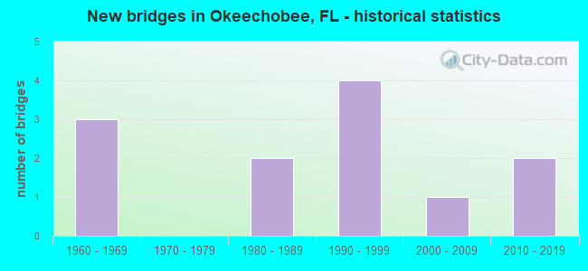
- New bridges - historical statistics
- 31960-1969
- 21980-1989
- 41990-1999
- 12000-2009
- 22010-2019


- Bridge Condition - Deck
- 22.2%Very good
- 77.8%Good

- Bridge Condition - Superstructure
- 22.2%Very good
- 77.8%Good

- Bridge Condition - Substructure
- 11.1%Excellent
- 88.9%Good

- Bridge Condition - Channel
- 10.0%Very good
- 70.0%Good
- 20.0%Satisfactory

- Bridge Condition - Culverts
- 66.7%Good
- 33.3%Satisfactory
Find on map >> Show street view
Structure Number: 80031, Location: 1.4 MILE SOUTH OF CR550 (Lat: 28.532472, Lng: -82.627139), Route carried "on" structure: County highway CR597, Year Built: 1985, Status: Open, Structure Length: 3.05m (10.01ft), Average Daily Traffic: 3,000 (year 2020), Truck Traffic: 2%, Average Future Daily Traffic: 3,750 (year 2040), Features Intersected: WEEKI WACHEE RIVER, Facility Carried by Structure: SHOAL LINE BLVD
Minimum Vertical Clearance: 30+ m (98+ ft), Kilometerpoint: 9.391, Lanes on structure: 2, Owner: County Highway Agency, Approaching Roadway Width: 10.4m (34.1ft), Material/Design: Concrete continuous, Design/Construction: Slab, Number Of Spans In Main Unit: 3, Length of Maximum Span: 11.4m (37.4ft), Curb or Sidewalk Widths: Left: 0.0m, Right: 1.3m (4.3ft), Curb-To-Curb Width: 9.8m (32.2ft), Out-to-Out Width: 12.0m (39.4ft)
Condition: Deck: Good, Superstructure: Good, Substructure: Good, Channel: Good, Operating Rating: 85.5 metric tons, Method Used To Determine Operating Rating: Load Factor (LF), Inventory Rating: 51.3 metric tons, Method Used To Determine Inventory Rating: Load Factor (LF), Structural Evaluation: Better than present minimum criteria, Deck Geometry: Meets minimum limits, Waterway Adequacy: Equal to present desirable criteria, Approach Roadway Alignment: Better than present minimum criteria, Designated Inspection Frequency: Every 24 months, Underwater Inspection Frequency: Every 24 months, Inspection Date: March 2020, Underwater Inspection Date: Febuary 2020, Deck Structure Type: Concrete Cast-file-Place
Find on map >> Show street view
Structure Number: 910003, Location: 1.6 MI WEST OF US-98 (Lat: 27.243531, Lng: -80.857953), Route carried "on" structure: State highway 70, Year Built: 1968, Status: Open, Structure Length: 0.63m (2.07ft), Average Daily Traffic: 9,700 (year 2020), Truck Traffic: 14%, Average Future Daily Traffic: 16,830 (year 2042), Design Load: HS 20+Mod, Features Intersected: EAGLE BAY CREEK
Minimum Vertical Clearance: 30+ m (98+ ft), Kilometerpoint: 12.501, Lanes on structure: 2, Base Highway Network: Yes, Owner: State Highway Agency, Approaching Roadway Width: 9.8m (32.2ft), Material/Design: Concrete, Design/Construction: Culvert, Number Of Spans In Main Unit: 2, Length of Maximum Span: 3.0m (9.8ft)
Condition: Channel: Very good, Culverts: Satisfactory, Operating Rating: 75.7 metric tons, Method Used To Determine Operating Rating: Load Factor (LF), Inventory Rating: 45.4 metric tons, Method Used To Determine Inventory Rating: Load Factor (LF), Structural Evaluation: Equal to present minimum criteria, Waterway Adequacy: Equal to present desirable criteria, Approach Roadway Alignment: Equal to present desirable criteria, Designated Inspection Frequency: Every 24 months, Inspection Date: April 2020
Find on map >> Show street view
Structure Number: 910081, Location: 0.6 MI. EAST OF US-441 (Lat: 27.243714, Lng: -80.822372), Route carried "on" structure: State highway 70, Year Built: 1983, Status: Open, Structure Length: 5.55m (18.21ft), Average Daily Traffic: 25,000 (year 2020), Truck Traffic: 18%, Average Future Daily Traffic: 43,375 (year 2042), Design Load: HS 20+Mod, Features Intersected: TAYLOR CREEK
Minimum Vertical Clearance: 30+ m (98+ ft), Kilometerpoint: 15.998, Lanes on structure: 5, Base Highway Network: Yes, Owner: State Highway Agency, Approaching Roadway Width: 20.2m (66.3ft), Skew: 23 degrees, Material/Design: Prestressed concrete, Design/Construction: Stringer/Multi-beam, Number Of Spans In Main Unit: 3, Length of Maximum Span: 18.5m (60.7ft), Curb or Sidewalk Widths: Left: 1.5m (4.9ft), Right: 1.5m (4.9ft), Curb-To-Curb Width: 20.2m (66.3ft), Out-to-Out Width: 28.4m (93.2ft)
Condition: Deck: Good, Superstructure: Good, Substructure: Good, Channel: Good, Operating Rating: 49.0 metric tons, Method Used To Determine Operating Rating: Load Testing, Inventory Rating: 28.0 metric tons, Method Used To Determine Inventory Rating: Load Testing, Structural Evaluation: Better than present minimum criteria, Deck Geometry: Somewhat better than minimum adequacy, Waterway Adequacy: Better than present minimum criteria, Approach Roadway Alignment: Better than present minimum criteria, Designated Inspection Frequency: Every 24 months, Underwater Inspection Frequency: Every 24 months, Inspection Date: April 2020, Underwater Inspection Date: March 2020, Deck Structure Type: Concrete Cast-file-Place
Find on map >> Show street view
Structure Number: 910092, Location: 1.3 MI EAST OF US-441 (Lat: 27.244542, Lng: -80.807394), Route carried "on" structure: State highway 70, Year Built: 1996, Status: Open, Structure Length: 3.92m (12.86ft), Average Daily Traffic: 12,250 (year 2020), Truck Traffic: 17%, Average Future Daily Traffic: 21,254 (year 2042), Design Load: HS 20+Mod, Features Intersected: CSX RAILROAD
Minimum Vertical Clearance: 30+ m (98+ ft), Kilometerpoint: 17.508, Lanes on structure: 2, Base Highway Network: Yes, Owner: State Highway Agency, Approaching Roadway Width: 9.1m (29.9ft), Skew: 3 degrees, Material/Design: Prestressed concrete, Design/Construction: Stringer/Multi-beam, Number Of Spans In Main Unit: 1, Length of Maximum Span: 39.2m (128.6ft), Curb or Sidewalk Widths: Left: 0.0m, Right: 2.4m (7.9ft), Curb-To-Curb Width: 11.0m (36.1ft), Out-to-Out Width: 14.6m (47.9ft)
Condition: Deck: Good, Superstructure: Good, Substructure: Good, Inventory Rating: 64.0 metric tons, Method Used To Determine Inventory Rating: Load Factor (LF), Structural Evaluation: Better than present minimum criteria, Deck Geometry: Equal to present minimum criteria, Underclear: Better than present minimum criteria, Approach Roadway Alignment: Equal to present desirable criteria, Designated Inspection Frequency: Every 24 months, Inspection Date: April 2020, Deck Structure Type: Concrete Cast-file-Place
Find on map >> Show street view
Structure Number: 910093, Location: 1.3 MI EAST OF US-441 (Lat: 27.244694, Lng: -80.807553), Route carried "on" structure: State highway 70, Year Built: 1996, Status: Open, Structure Length: 3.93m (12.89ft), Average Daily Traffic: 12,250 (year 2020), Truck Traffic: 17%, Average Future Daily Traffic: 21,254 (year 2042), Design Load: HS 20+Mod, Features Intersected: CSX RAILROAD
Minimum Vertical Clearance: 30+ m (98+ ft), Kilometerpoint: 17.494, Lanes on structure: 2, Base Highway Network: Yes, Owner: State Highway Agency, Approaching Roadway Width: 9.3m (30.5ft), Skew: 3 degrees, Material/Design: Prestressed concrete, Design/Construction: Stringer/Multi-beam, Number Of Spans In Main Unit: 1, Length of Maximum Span: 39.3m (128.9ft), Curb or Sidewalk Widths: Left: 2.4m (7.9ft), Right: 0.0m, Curb-To-Curb Width: 11.0m (36.1ft), Out-to-Out Width: 14.7m (48.2ft)
Condition: Deck: Good, Superstructure: Good, Substructure: Good, Inventory Rating: 72.6 metric tons, Method Used To Determine Inventory Rating: Load Factor (LF), Structural Evaluation: Better than present minimum criteria, Deck Geometry: Equal to present minimum criteria, Underclear: Better than present minimum criteria, Approach Roadway Alignment: Equal to present desirable criteria, Designated Inspection Frequency: Every 24 months, Inspection Date: April 2020, Deck Structure Type: Concrete Cast-file-Place
Find on map >> Show street view
Structure Number: 910094, Location: 1.6MI W OF US-98/441 (Lat: 27.187519, Lng: -80.851492), Route carried "on" structure: State highway 78, Year Built: 1995, Status: Open, Structure Length: 8.66m (28.41ft), Average Daily Traffic: 6,700 (year 2020), Truck Traffic: 20%, Average Future Daily Traffic: 11,624 (year 2042), Design Load: HS 25 or greater, Features Intersected: LEMKIN CREEK
Minimum Vertical Clearance: 30+ m (98+ ft), Kilometerpoint: 4.952, Lanes on structure: 2, Base Highway Network: Yes, Owner: State Highway Agency, Approaching Roadway Width: 9.8m (32.2ft), Skew: 4 degrees, Material/Design: Concrete continuous, Design/Construction: Slab, Number Of Spans In Main Unit: 7, Length of Maximum Span: 12.4m (40.7ft), Curb-To-Curb Width: 13.4m (44.0ft), Out-to-Out Width: 14.6m (47.9ft)
Condition: Deck: Good, Superstructure: Good, Substructure: Good, Channel: Good, Operating Rating: 81.7 metric tons, Method Used To Determine Operating Rating: Load Factor (LF), Inventory Rating: 48.9 metric tons, Method Used To Determine Inventory Rating: Load Factor (LF), Structural Evaluation: Better than present minimum criteria, Deck Geometry: Equal to present minimum criteria, Waterway Adequacy: Superior to present desirable criteria, Approach Roadway Alignment: Equal to present desirable criteria, Designated Inspection Frequency: Every 24 months, Underwater Inspection Frequency: Every 24 months, Inspection Date: April 2020, Underwater Inspection Date: March 2020, Deck Structure Type: Concrete Cast-file-Place
Find on map >> Show street view
Structure Number: 910095, Location: 2.0 MI. EAST OF SR-710 (Lat: 27.253506, Lng: -80.770028), Route carried "on" structure: State highway 70, Year Built: 1999, Year Reconstructed: 2017, Status: Open, Structure Length: 5.47m (17.95ft), Average Daily Traffic: 4,850 (year 2020), Truck Traffic: 17%, Average Future Daily Traffic: 8,415 (year 2042), Design Load: HL 93, Features Intersected: MOSQUITO CREEK
Minimum Vertical Clearance: 30+ m (98+ ft), Kilometerpoint: 21.364, Lanes on structure: 2, Base Highway Network: Yes, Owner: State Highway Agency, Approaching Roadway Width: 13.2m (43.3ft), Material/Design: Concrete continuous, Design/Construction: Slab, Number Of Spans In Main Unit: 6, Length of Maximum Span: 9.2m (30.2ft), Curb or Sidewalk Widths: Left: 0.0m, Right: 1.6m (5.2ft), Curb-To-Curb Width: 13.2m (43.3ft), Out-to-Out Width: 15.9m (52.2ft)
Condition: Deck: Good, Superstructure: Good, Substructure: Good, Channel: Good, Operating Rating: 52.3 metric tons, Method Used To Determine Operating Rating: Load and Resistance Factor (LRFR), Inventory Rating: 40.2 metric tons, Method Used To Determine Inventory Rating: Load and Resistance Factor (LRFR), Structural Evaluation: Better than present minimum criteria, Deck Geometry: Equal to present minimum criteria, Waterway Adequacy: Superior to present desirable criteria, Approach Roadway Alignment: Equal to present desirable criteria, Designated Inspection Frequency: Every 24 months, Inspection Date: April 2020, Deck Structure Type: Concrete Cast-file-Place
Find on map >> Show street view
Structure Number: 910103, Location: 0.9 MI E OF SR-710 (Lat: 27.250450, Lng: -80.789083), Route carried "on" structure: State highway 70, Year Built: 2017, Status: Open, Structure Length: 7.04m (23.10ft), Average Daily Traffic: 4,850 (year 2021), Truck Traffic: 17%, Average Future Daily Traffic: 8,415 (year 2042), Design Load: HL 93, Features Intersected: L-63N CANAL
Minimum Vertical Clearance: 30+ m (98+ ft), Kilometerpoint: 19.439, Lanes on structure: 3, Base Highway Network: Yes, Owner: State Highway Agency, Approaching Roadway Width: 14.4m (47.2ft), Material/Design: Prestressed concrete, Design/Construction: Stringer/Multi-beam, Number Of Spans In Main Unit: 3, Length of Maximum Span: 23.5m (77.1ft), Curb or Sidewalk Widths: Left: 0.0m, Right: 1.8m (5.9ft), Curb-To-Curb Width: 12.8m (42.0ft), Out-to-Out Width: 17.2m (56.4ft)
Condition: Deck: Very good, Superstructure: Very good, Substructure: Good, Channel: Good, Operating Rating: 47.0 metric tons, Method Used To Determine Operating Rating: Load and Resistance Factor (LRFR), Inventory Rating: 40.2 metric tons, Method Used To Determine Inventory Rating: Load and Resistance Factor (LRFR), Structural Evaluation: Better than present minimum criteria, Deck Geometry: Meets minimum limits, Waterway Adequacy: Equal to present desirable criteria, Approach Roadway Alignment: Equal to present desirable criteria, Designated Inspection Frequency: Every 24 months, Underwater Inspection Frequency: Every 24 months, Inspection Date: October 2021, Underwater Inspection Date: September 2021, Deck Structure Type: Concrete Cast-file-Place
Find on map >> Show street view
Structure Number: 914011, Location: 2.0MI W OF US-441 (Lat: 27.229008, Lng: -80.861136), Route carried "on" structure: Alternate County highway 70A, Year Built: 1962, Status: Open, Structure Length: 1.07m (3.51ft), Average Daily Traffic: 750 (year 2020), Truck Traffic: 8%, Average Future Daily Traffic: 1,302 (year 2042), Design Load: HS 15, Features Intersected: RELIEF CANAL
Minimum Vertical Clearance: 30+ m (98+ ft), Kilometerpoint: 3.312, Lanes on structure: 2, Owner: County Highway Agency, Approaching Roadway Width: 6.5m (21.3ft), Material/Design: Concrete, Design/Construction: Culvert, Number Of Spans In Main Unit: 3, Length of Maximum Span: 3.1m (10.2ft)
Condition: Channel: Satisfactory, Culverts: Good, Operating Rating: 58.8 metric tons, Method Used To Determine Operating Rating: Load Factor (LF), Inventory Rating: 35.3 metric tons, Method Used To Determine Inventory Rating: Load Factor (LF), Structural Evaluation: Better than present minimum criteria, Waterway Adequacy: Equal to present minimum criteria, Approach Roadway Alignment: Equal to present desirable criteria, Designated Inspection Frequency: Every 24 months, Inspection Date: Febuary 2021
Find on map >> Show street view
Structure Number: 914012, Location: 2MI WEST OF US-441 (Lat: 27.218086, Lng: -80.861056), Route carried "on" structure: City street , Year Built: 1962, Status: Open, Structure Length: 0.81m (2.66ft), Average Daily Traffic: 600 (year 2020), Truck Traffic: 10%, Average Future Daily Traffic: 1,041 (year 2042), Design Load: H 15, Features Intersected: RELIEF CANAL, Facility Carried by Structure: SW 28TH ST WOLF RD
Minimum Vertical Clearance: 30+ m (98+ ft), Kilometerpoint: 0.000, Lanes on structure: 2, Owner: County Highway Agency, Approaching Roadway Width: 6.9m (22.6ft), Material/Design: Concrete, Design/Construction: Culvert, Number Of Spans In Main Unit: 2, Length of Maximum Span: 3.4m (11.2ft)
Condition: Channel: Satisfactory, Culverts: Good, Operating Rating: 61.7 metric tons, Method Used To Determine Operating Rating: Load Factor (LF), Inventory Rating: 36.9 metric tons, Method Used To Determine Inventory Rating: Load Factor (LF), Structural Evaluation: Better than present minimum criteria, Waterway Adequacy: Equal to present minimum criteria, Approach Roadway Alignment: Equal to present desirable criteria, Designated Inspection Frequency: Every 24 months, Inspection Date: Febuary 2021
Find on map >> Show street view
Structure Number: 915008, Location: 0.3 MI E OF US-441 (Lat: 27.252636, Lng: -80.823961), Route carried "on" structure: City street , Year Built: 2004, Status: Open, Structure Length: 4.57m (14.99ft), Average Daily Traffic: 1,850 (year 2020), Truck Traffic: 18%, Average Future Daily Traffic: 3,210 (year 2042), Design Load: HL 93, Features Intersected: TAYLOR CREEK, Facility Carried by Structure: NE 9TH ST
Minimum Vertical Clearance: 30+ m (98+ ft), Kilometerpoint: 2.834, Lanes on structure: 2, Owner: City or Municipal Highway Agency, Approaching Roadway Width: 9.0m (29.5ft), Material/Design: Prestressed concrete, Design/Construction: Slab, Number Of Spans In Main Unit: 5, Length of Maximum Span: 9.1m (29.9ft), Curb-To-Curb Width: 9.0m (29.5ft), Out-to-Out Width: 9.9m (32.5ft)
Condition: Deck: Good, Superstructure: Good, Substructure: Good, Channel: Good, Inventory Rating: 60.8 metric tons, Method Used To Determine Inventory Rating: Load Factor (LF), Structural Evaluation: Better than present minimum criteria, Deck Geometry: Somewhat better than minimum adequacy, Waterway Adequacy: Better than present minimum criteria, Approach Roadway Alignment: Equal to present desirable criteria, Designated Inspection Frequency: Every 24 months, Underwater Inspection Frequency: Every 24 months, Inspection Date: Febuary 2021, Underwater Inspection Date: January 2021, Deck Structure Type: Concrete Precast Panels, Wearing Surface/Protective System: Wearing Surface: Bituminous
Find on map >> Show street view
Structure Number: 919001, Location: 1.6MI WEST OF US 98 (Lat: 27.243628, Lng: -80.857953), Route carried "on" structure: ServiceOther road 70, Year Built: 2016, Status: Open, Structure Length: 1.68m (5.51ft), Average Daily Traffic: 40 (year 2020), Average Future Daily Traffic: 60 (year 2042), Design Load: Pedestrian, Features Intersected: EAGLE BAY CREEK, Facility Carried by Structure: PED. OVERPASS
Minimum Vertical Clearance: 30.18m (99.02ft), Kilometerpoint: 12.485, Lanes on structure: 1, Owner: State Highway Agency, Approaching Roadway Width: 2.5m (8.2ft), Material/Design: Prestressed concrete, Design/Construction: Tee Beam, Number Of Spans In Main Unit: 1, Length of Maximum Span: 16.8m (55.1ft), Curb-To-Curb Width: 2.5m (8.2ft), Out-to-Out Width: 2.9m (9.5ft)
Condition: Deck: Very good, Superstructure: Very good, Substructure: Excellent, Channel: Good, Structural Evaluation: High priority of corrective action, Deck Geometry: High priority of replacement, Waterway Adequacy: Equal to present desirable criteria, Approach Roadway Alignment: Equal to present desirable criteria, Designated Inspection Frequency: Every 24 months, Inspection Date: December 2020, Deck Structure Type: Concrete Precast Panels