Bridge Statistics for Ojai, California (CA)
Condition, Traffic, Stress, Structural Evaluation, Project Costs
- National Bridge Inventory (NBI) Statistics
- 18Number of bridges
- 108ft / 32.7mTotal length
- 38,750Total average daily traffic
- 1,139Total average daily truck traffic
- 35,645Total future (year 2036) average daily traffic
- National Bridge Inventory (NBI) Registered Bridges for Ojai
- No street view available for this location
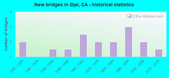
- New bridges - historical statistics
- 21920-1929
- 11940-1949
- 11950-1959
- 31960-1969
- 21970-1979
- 21980-1989
- 41990-1999
- 22000-2009
- 12010-2019
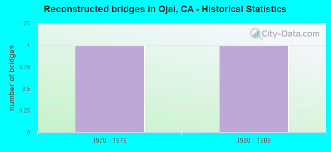
- Reconstructed bridges - Historical Statistics
- 11970-1979
- 11980-1989
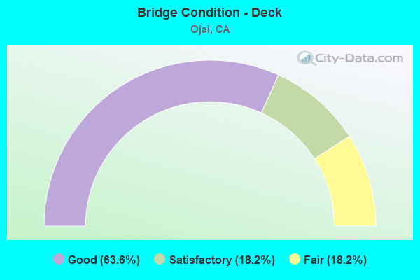
- Bridge Condition - Deck
- 63.6%Good
- 18.2%Satisfactory
- 18.2%Fair
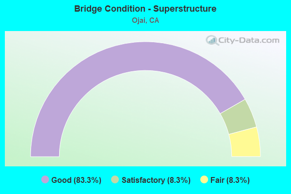
- Bridge Condition - Superstructure
- 83.3%Good
- 8.3%Satisfactory
- 8.3%Fair
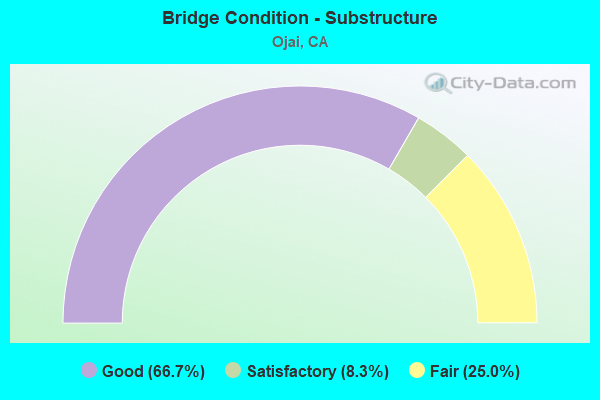
- Bridge Condition - Substructure
- 66.7%Good
- 8.3%Satisfactory
- 25.0%Fair
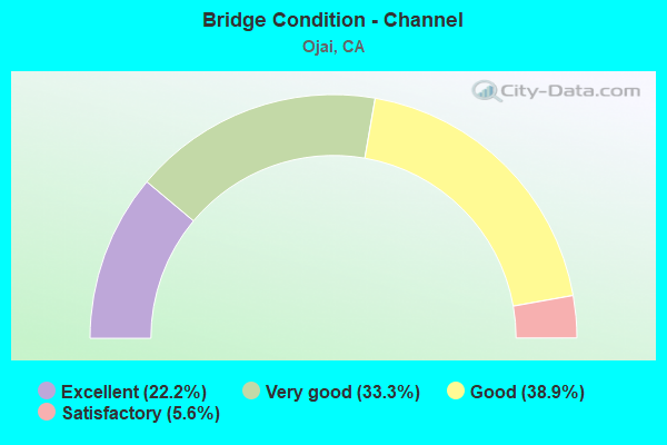
- Bridge Condition - Channel
- 22.2%Excellent
- 33.3%Very good
- 38.9%Good
- 5.6%Satisfactory
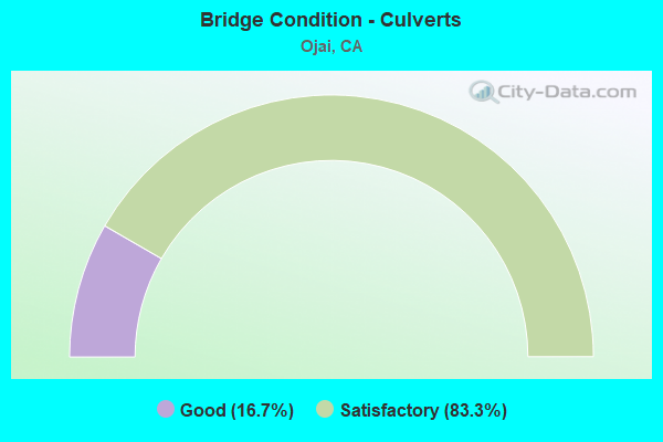
- Bridge Condition - Culverts
- 16.7%Good
- 83.3%Satisfactory
Find on map >> Show street view
Structure Number: 52 0074, Location: 07-VEN-033-19.36 (Lat: 34.513733, Lng: -119.271931), Route carried "on" structure: State highway 33, Year Built: 1995, Status: Open, Structure Length: 2.21m (7.25ft), Average Daily Traffic: 650 (year 2010), Truck Traffic: 4%, Average Future Daily Traffic: 1,781 (year 2037), Design Load: HS 20+Mod, Features Intersected: BEAR CREEK
Minimum Vertical Clearance: 30+ m (98+ ft), Kilometerpoint: 19.360, Lanes on structure: 2, Base Highway Network: Yes (, Subroute: 1), Owner: State Highway Agency, Approaching Roadway Width: 9.8m (32.2ft), Skew: 3 degrees, Material/Design: Prestressed concrete, Design/Construction: Box Beam or Girders - Multiple, Number Of Spans In Main Unit: 1, Length of Maximum Span: 21.2m (69.6ft), Curb-To-Curb Width: 9.8m (32.2ft), Out-to-Out Width: 10.8m (35.4ft)
Condition: Deck: Good, Superstructure: Good, Substructure: Good, Channel: Very good, Operating Rating: 54.1 metric tons, Method Used To Determine Operating Rating: Assigned rating based on Load Factor Design (LFD) reported in metric tons, Inventory Rating: 32.4 metric tons, Method Used To Determine Inventory Rating: Assigned rating based on Load Factor Design (LFD) reported in metric tons, Structural Evaluation: Better than present minimum criteria, Deck Geometry: Equal to present minimum criteria, Waterway Adequacy: Equal to present desirable criteria, Approach Roadway Alignment: Equal to present desirable criteria, Designated Inspection Frequency: Every 48 months, Inspection Date: June 2020, Deck Structure Type: Concrete Cast-file-Place
Find on map >> Show street view
Structure Number: 52 0098, Location: 07-VEN-150-19.56 (Lat: 34.446561, Lng: -119.211447), Route carried "on" structure: State highway 150, Year Built: 1973, Year Reconstructed: 1978, Status: Open, Structure Length: 2.17m (7.12ft), Average Daily Traffic: 4,600 (year 2020), Truck Traffic: 4%, Average Future Daily Traffic: 6,000 (year 2041), Design Load: HS 20, Features Intersected: THACHER CREEK
Minimum Vertical Clearance: 30+ m (98+ ft), Kilometerpoint: 19.560, Lanes on structure: 2, Base Highway Network: Yes (Inventory Route: 1, Subroute: 3), Owner: State Highway Agency, Approaching Roadway Width: 10.9m (35.8ft), Skew: 5 degrees, Material/Design: Prestressed concrete, Design/Construction: Box Beam or Girders - Multiple, Number Of Spans In Main Unit: 1, Length of Maximum Span: 21.1m (69.2ft), Curb-To-Curb Width: 10.9m (35.8ft), Out-to-Out Width: 15.2m (49.9ft)
Condition: Deck: Good, Superstructure: Good, Substructure: Fair, Channel: Satisfactory, Operating Rating: 61.6 metric tons, Method Used To Determine Operating Rating: Load Factor (LF), Inventory Rating: 32.4 metric tons, Method Used To Determine Inventory Rating: Load Factor (LF), Structural Evaluation: Somewhat better than minimum adequacy, Deck Geometry: Somewhat better than minimum adequacy, Waterway Adequacy: Equal to present minimum criteria, Approach Roadway Alignment: Equal to present desirable criteria, Designated Inspection Frequency: Every 24 months, Inspection Date: September 2021, Deck Structure Type: Concrete Cast-file-Place
Find on map >> Show street view
Structure Number: 52 0099, Location: 07-VEN-150-21.70 (Lat: 34.433114, Lng: -119.200542), Route carried "on" structure: State highway 150, Year Built: 1921, Status: Open, Structure Length: 1.37m (4.49ft), Average Daily Traffic: 2,500 (year 2020), Truck Traffic: 4%, Average Future Daily Traffic: 3,500 (year 2041), Features Intersected: LION CANYON CREEK
Minimum Vertical Clearance: 30+ m (98+ ft), Kilometerpoint: 21.700, Lanes on structure: 2, Base Highway Network: Yes (Inventory Route: 1, Subroute: 3), Owner: State Highway Agency, Approaching Roadway Width: 7.3m (24.0ft), Material/Design: Concrete, Design/Construction: Arch - Deck, Number Of Spans In Main Unit: 1, Length of Maximum Span: 12.9m (42.3ft), Curb-To-Curb Width: 6.1m (20.0ft), Out-to-Out Width: 7.3m (24.0ft)
Condition: Superstructure: Good, Substructure: Good, Channel: Good, Operating Rating: 27.2 metric tons, Method Used To Determine Operating Rating: Field evaluation and documented engineering judgment, Inventory Rating: 16.2 metric tons, Method Used To Determine Inventory Rating: Field evaluation and documented engineering judgment, Structural Evaluation: Meets minimum limits, Deck Geometry: High priority of replacement, Waterway Adequacy: Equal to present desirable criteria, Approach Roadway Alignment: Equal to present minimum criteria, Designated Inspection Frequency: Every 24 months, Inspection Date: September 2021
Find on map >> Show street view
Structure Number: 52 0419Z, Location: 07-VEN-150-R23.14 (Lat: 34.436433, Lng: -119.176061), Route carried "on" structure: ServiceState highway 150, Year Built: 1983, Status: Open, Structure Length: 2.06m (6.76ft), Average Daily Traffic: 50 (year 2020), Truck Traffic: 1%, Average Future Daily Traffic: 75 (year 2041), Design Load: HS 20+Mod, Features Intersected: LION CANYON CREEK, Facility Carried by Structure: OLD WALNUT ROAD
Minimum Vertical Clearance: 30+ m (98+ ft), Kilometerpoint: 23.140, Lanes on structure: 2, Owner: State Highway Agency, Approaching Roadway Width: 11.0m (36.1ft), Material/Design: Concrete, Design/Construction: Box Beam or Girders - Multiple, Number Of Spans In Main Unit: 1, Length of Maximum Span: 19.8m (65.0ft), Curb-To-Curb Width: 11.0m (36.1ft), Out-to-Out Width: 12.0m (39.4ft)
Condition: Deck: Fair, Superstructure: Good, Substructure: Fair, Channel: Good, Operating Rating: 54.1 metric tons, Method Used To Determine Operating Rating: Assigned rating based on Load Factor Design (LFD) reported in metric tons, Inventory Rating: 32.4 metric tons, Method Used To Determine Inventory Rating: Assigned rating based on Load Factor Design (LFD) reported in metric tons, Structural Evaluation: Somewhat better than minimum adequacy, Deck Geometry: Superior to present desirable criteria, Waterway Adequacy: Equal to present minimum criteria, Approach Roadway Alignment: Equal to present minimum criteria, Designated Inspection Frequency: Every 24 months, Inspection Date: September 2021, Deck Structure Type: Concrete Cast-file-Place
Find on map >> Show street view
Structure Number: 52 0441, Location: 07-VEN-033-18.84 (Lat: 34.507917, Lng: -119.275294), Route carried "on" structure: State highway 33, Year Built: 2000, Status: Open, Structure Length: 3.05m (10.01ft), Average Daily Traffic: 700 (year 2010), Truck Traffic: 4%, Average Future Daily Traffic: 1,000 (year 2037), Design Load: HS 20+Mod, Features Intersected: N FORK MATILIJA CREEK
Minimum Vertical Clearance: 30+ m (98+ ft), Kilometerpoint: 18.840, Lanes on structure: 2, Base Highway Network: Yes (, Subroute: 1), Owner: State Highway Agency, Approaching Roadway Width: 7.7m (25.3ft), Material/Design: Prestressed concrete, Design/Construction: Box Beam or Girders - Multiple, Number Of Spans In Main Unit: 1, Length of Maximum Span: 29.7m (97.4ft), Curb-To-Curb Width: 7.7m (25.3ft), Out-to-Out Width: 8.8m (28.9ft)
Condition: Deck: Good, Superstructure: Good, Substructure: Good, Channel: Excellent, Operating Rating: 54.1 metric tons, Method Used To Determine Operating Rating: Assigned rating based on Load Factor Design (LFD) reported in metric tons, Inventory Rating: 32.4 metric tons, Method Used To Determine Inventory Rating: Assigned rating based on Load Factor Design (LFD) reported in metric tons, Structural Evaluation: Better than present minimum criteria, Deck Geometry: Meets minimum limits, Waterway Adequacy: Superior to present desirable criteria, Approach Roadway Alignment: Equal to present desirable criteria, Designated Inspection Frequency: Every 48 months, Inspection Date: June 2018, Deck Structure Type: Concrete Cast-file-Place
Find on map >> Show street view
Structure Number: 52 0453, Location: 07-VEN-033-19.72 (Lat: 34.518519, Lng: -119.270928), Route carried "on" structure: State highway 33, Year Built: 2001, Status: Open, Structure Length: 2.52m (8.27ft), Average Daily Traffic: 650 (year 2010), Truck Traffic: 4%, Average Future Daily Traffic: 1,746 (year 2037), Design Load: HS 20+Mod, Features Intersected: NORTH FORK MATILIJA CRK
Minimum Vertical Clearance: 30+ m (98+ ft), Kilometerpoint: 19.720, Lanes on structure: 2, Base Highway Network: Yes (, Subroute: 1), Owner: State Highway Agency, Approaching Roadway Width: 9.6m (31.5ft), Skew: 3 degrees, Material/Design: Prestressed concrete, Design/Construction: Box Beam or Girders - Multiple, Number Of Spans In Main Unit: 1, Length of Maximum Span: 24.4m (80.1ft), Curb-To-Curb Width: 9.6m (31.5ft), Out-to-Out Width: 10.7m (35.1ft)
Condition: Deck: Good, Superstructure: Good, Substructure: Good, Channel: Excellent, Operating Rating: 54.1 metric tons, Method Used To Determine Operating Rating: Assigned rating based on Load Factor Design (LFD) reported in metric tons, Inventory Rating: 32.4 metric tons, Method Used To Determine Inventory Rating: Assigned rating based on Load Factor Design (LFD) reported in metric tons, Structural Evaluation: Better than present minimum criteria, Deck Geometry: Equal to present minimum criteria, Waterway Adequacy: Equal to present desirable criteria, Approach Roadway Alignment: Equal to present desirable criteria, Designated Inspection Frequency: Every 48 months, Inspection Date: June 2020, Deck Structure Type: Concrete Cast-file-Place
Find on map >> Show street view
Structure Number: 52 0464, Location: 07-VEN-150-18.75 (Lat: 34.449003, Lng: -119.225308), Route carried "on" structure: State highway 150, Year Built: 2010, Status: Open, Structure Length: 5.49m (18.01ft), Average Daily Traffic: 21,150 (year 2009), Truck Traffic: 3%, Average Future Daily Traffic: 10,242 (year 2041), Design Load: HL 93, Features Intersected: SAN ANTONIO CREEK
Minimum Vertical Clearance: 30+ m (98+ ft), Kilometerpoint: 18.750, Lanes on structure: 2, Base Highway Network: Yes (Inventory Route: 1, Subroute: 3), Owner: State Highway Agency, Approaching Roadway Width: 12.2m (40.0ft), Skew: 3 degrees, Material/Design: Prestressed concrete continuous, Design/Construction: Stringer/Multi-beam, Number Of Spans In Main Unit: 2, Length of Maximum Span: 27.1m (88.9ft), Curb-To-Curb Width: 12.2m (40.0ft), Out-to-Out Width: 13.3m (43.6ft)
Condition: Deck: Good, Superstructure: Good, Substructure: Good, Channel: Excellent, Operating Rating: 54.0 metric tons, Method Used To Determine Operating Rating: Field evaluation and documented engineering judgment, Inventory Rating: 32.4 metric tons, Method Used To Determine Inventory Rating: Field evaluation and documented engineering judgment, Structural Evaluation: Better than present minimum criteria, Deck Geometry: Somewhat better than minimum adequacy, Waterway Adequacy: Equal to present desirable criteria, Approach Roadway Alignment: Equal to present desirable criteria, Designated Inspection Frequency: Every 48 months, Inspection Date: September 2019, Deck Structure Type: Concrete Cast-file-Place, Wearing Surface/Protective System: Wearing Surface: Integral Concrete
Find on map >> Show street view
Structure Number: 52C0189, Location: 0.1 MI N REEVES RD (Lat: 34.448789, Lng: -119.184878), Route carried "on" structure: County highway , Year Built: 1983, Status: Open, Structure Length: 1.01m (3.31ft), Average Daily Traffic: 500 (year 2019), Truck Traffic: 1%, Average Future Daily Traffic: 726 (year 2038), Design Load: HS 20, Features Intersected: REEVES CREEK, Facility Carried by Structure: MCANDREW RD
Minimum Vertical Clearance: 30+ m (98+ ft), Kilometerpoint: 0.000, Lanes on structure: 2, Owner: County Highway Agency, Approaching Roadway Width: 7.3m (24.0ft), Skew: 2 degrees, Material/Design: Concrete, Design/Construction: Culvert, Number Of Spans In Main Unit: 1, Length of Maximum Span: 8.5m (27.9ft), Curb-To-Curb Width: 10.0m (32.8ft), Out-to-Out Width: 11.1m (36.4ft)
Condition: Channel: Good, Culverts: Satisfactory, Operating Rating: 54.1 metric tons, Method Used To Determine Operating Rating: Field evaluation and documented engineering judgment, Inventory Rating: 32.4 metric tons, Method Used To Determine Inventory Rating: Field evaluation and documented engineering judgment, Structural Evaluation: Equal to present minimum criteria, Deck Geometry: Equal to present minimum criteria, Waterway Adequacy: Superior to present desirable criteria, Approach Roadway Alignment: Equal to present desirable criteria, Designated Inspection Frequency: Every 48 months, Inspection Date: March 2019, Deck Structure Type: Concrete Cast-file-Place
Find on map >> Show street view
Structure Number: 52C0191, Location: 0.1 MI N OF S.R. 150 (Lat: 34.446792, Lng: -119.206347), Route carried "on" structure: County highway , Year Built: 1928, Status: Open, Structure Length: 1.16m (3.81ft), Average Daily Traffic: 900 (year 2017), Truck Traffic: 1%, Average Future Daily Traffic: 1,245 (year 2038), Features Intersected: THACHER CREEK, Facility Carried by Structure: CARNE RD
Minimum Vertical Clearance: 30+ m (98+ ft), Kilometerpoint: 0.000, Lanes on structure: 2, Owner: County Highway Agency, Approaching Roadway Width: 7.0m (23.0ft), Skew: 1 degrees, Material/Design: Concrete, Design/Construction: Tee Beam, Number Of Spans In Main Unit: 1, Length of Maximum Span: 11.0m (36.1ft), Curb-To-Curb Width: 6.5m (21.3ft), Out-to-Out Width: 7.3m (24.0ft)
Condition: Deck: Good, Superstructure: Good, Substructure: Fair, Channel: Very good, Operating Rating: 19.4 metric tons, Method Used To Determine Operating Rating: Load and Resistance Factor Rating (LRFR) rating reported by rating factor(RF) method using HL-93 loadings, Inventory Rating: 13.3 metric tons, Method Used To Determine Inventory Rating: Load and Resistance Factor Rating (LRFR) rating reported by rating factor(RF) method using HL-93 loadings, Structural Evaluation: Meets minimum limits, Deck Geometry: High priority of corrective action, Waterway Adequacy: Superior to present desirable criteria, Approach Roadway Alignment: Equal to present desirable criteria, Designated Inspection Frequency: Every 24 months, Inspection Date: August 2020, Deck Structure Type: Concrete Cast-file-Place, Wearing Surface/Protective System: Wearing Surface: Bituminous
Find on map >> Show street view
Structure Number: 52C0192, Location: 0.4 MI E GRIDLEY RD (Lat: 34.454242, Lng: -119.222014), Route carried "on" structure: County highway , Year Built: 1945, Status: Open, Structure Length: 4.15m (13.62ft), Average Daily Traffic: 2,300 (year 2017), Truck Traffic: 2%, Average Future Daily Traffic: 3,113 (year 2038), Features Intersected: SAN ANTONIO CREEK, Facility Carried by Structure: GRAND AVE
Minimum Vertical Clearance: 30+ m (98+ ft), Kilometerpoint: 0.000, Lanes on structure: 2, Owner: County Highway Agency, Approaching Roadway Width: 7.3m (24.0ft), Skew: 3 degrees, Material/Design: Concrete continuous, Design/Construction: Slab, Number Of Spans In Main Unit: 7, Length of Maximum Span: 7.3m (24.0ft), Curb or Sidewalk Widths: Left: 0.6m (2.0ft), Right: 0.6m (2.0ft), Curb-To-Curb Width: 7.3m (24.0ft), Out-to-Out Width: 8.9m (29.2ft)
Condition: Deck: Fair, Superstructure: Fair, Substructure: Good, Channel: Very good, Operating Rating: 35.6 metric tons, Method Used To Determine Operating Rating: Load Factor (LF), Inventory Rating: 21.4 metric tons, Method Used To Determine Inventory Rating: Load Factor (LF), Structural Evaluation: Somewhat better than minimum adequacy, Deck Geometry: High priority of replacement, Waterway Adequacy: Equal to present desirable criteria, Approach Roadway Alignment: Equal to present desirable criteria, Designated Inspection Frequency: Every 24 months, Inspection Date: August 2020, Deck Structure Type: Concrete Cast-file-Place
Find on map >> Show street view
Structure Number: 52C0193, Location: 0.2 MI N OF GRAND AVE (Lat: 34.457119, Lng: -119.223922), Route carried "on" structure: County highway , Year Built: 1974, Status: Open, Structure Length: 1.07m (3.51ft), Average Daily Traffic: 200 (year 2019), Truck Traffic: 1%, Average Future Daily Traffic: 310 (year 2038), Design Load: HS 20, Features Intersected: GRIDLEY WASH, Facility Carried by Structure: ORANGE RD
Minimum Vertical Clearance: 30+ m (98+ ft), Kilometerpoint: 0.000, Lanes on structure: 2, Owner: County Highway Agency, Approaching Roadway Width: 6.1m (20.0ft), Skew: 5 degrees, Material/Design: Concrete, Design/Construction: Culvert, Number Of Spans In Main Unit: 2, Length of Maximum Span: 4.9m (16.1ft), Curb-To-Curb Width: 10.5m (34.4ft), Out-to-Out Width: 11.0m (36.1ft)
Condition: Channel: Very good, Culverts: Satisfactory, Operating Rating: 54.1 metric tons, Method Used To Determine Operating Rating: Field evaluation and documented engineering judgment, Inventory Rating: 32.4 metric tons, Method Used To Determine Inventory Rating: Field evaluation and documented engineering judgment, Structural Evaluation: Equal to present minimum criteria, Deck Geometry: Better than present minimum criteria, Waterway Adequacy: Better than present minimum criteria, Approach Roadway Alignment: Equal to present desirable criteria, Designated Inspection Frequency: Every 48 months, Inspection Date: March 2019
Find on map >> Show street view
Structure Number: 52C0194, Location: 0.1 MI N OF S.R. 150 (Lat: 34.449239, Lng: -119.219456), Route carried "on" structure: County highway , Year Built: 1965, Status: Open, Structure Length: 0.79m (2.59ft), Average Daily Traffic: 600 (year 2019), Truck Traffic: 1%, Average Future Daily Traffic: 829 (year 2038), Design Load: H 15, Features Intersected: MCNELL CREEK, Facility Carried by Structure: GORHAM RD
Minimum Vertical Clearance: 30+ m (98+ ft), Kilometerpoint: 0.000, Lanes on structure: 2, Owner: County Highway Agency, Approaching Roadway Width: 7.3m (24.0ft), Skew: 3 degrees, Material/Design: Concrete, Design/Construction: Culvert, Number Of Spans In Main Unit: 2, Length of Maximum Span: 3.7m (12.1ft), Curb-To-Curb Width: 11.7m (38.4ft), Out-to-Out Width: 12.2m (40.0ft)
Condition: Channel: Excellent, Culverts: Satisfactory, Operating Rating: 40.5 metric tons, Method Used To Determine Operating Rating: Field evaluation and documented engineering judgment, Inventory Rating: 24.3 metric tons, Method Used To Determine Inventory Rating: Field evaluation and documented engineering judgment, Structural Evaluation: Equal to present minimum criteria, Deck Geometry: Better than present minimum criteria, Waterway Adequacy: Superior to present desirable criteria, Approach Roadway Alignment: Equal to present desirable criteria, Designated Inspection Frequency: Every 24 months, Inspection Date: August 2020
Find on map >> Show street view
Structure Number: 52C0196, Location: 0.3 MI S OF S.R. 150 (Lat: 34.444767, Lng: -119.222694), Route carried "on" structure: County highway , Year Built: 1964, Status: Open, Structure Length: 0.82m (2.69ft), Average Daily Traffic: 500 (year 2017), Truck Traffic: 2%, Average Future Daily Traffic: 616 (year 2038), Features Intersected: THACHER CREEK, Facility Carried by Structure: BOARDMAN RD
Minimum Vertical Clearance: 30+ m (98+ ft), Kilometerpoint: 0.000, Lanes on structure: 2, Owner: County Highway Agency, Approaching Roadway Width: 7.3m (24.0ft), Skew: 1 degrees, Material/Design: Concrete, Design/Construction: Culvert, Number Of Spans In Main Unit: 2, Length of Maximum Span: 3.7m (12.1ft)
Condition: Channel: Very good, Culverts: Good, Operating Rating: 54.1 metric tons, Method Used To Determine Operating Rating: Field evaluation and documented engineering judgment, Inventory Rating: 32.4 metric tons, Method Used To Determine Inventory Rating: Field evaluation and documented engineering judgment, Structural Evaluation: Better than present minimum criteria, Waterway Adequacy: Equal to present desirable criteria, Approach Roadway Alignment: Equal to present desirable criteria, Designated Inspection Frequency: Every 48 months, Inspection Date: July 2018
Find on map >> Show street view
Structure Number: 52C0199, Location: 0.2 MI S OF S.R. 150 (Lat: 34.445014, Lng: -119.219594), Route carried "on" structure: County highway , Year Built: 1967, Status: Open, Structure Length: 0.85m (2.79ft), Average Daily Traffic: 200 (year 2019), Truck Traffic: 2%, Average Future Daily Traffic: 258 (year 2038), Features Intersected: THACHER CREEK, Facility Carried by Structure: AVENIDA DEL RECREO
Minimum Vertical Clearance: 30+ m (98+ ft), Kilometerpoint: 0.000, Lanes on structure: 2, Owner: County Highway Agency, Approaching Roadway Width: 9.1m (29.9ft), Skew: 3 degrees, Material/Design: Concrete, Design/Construction: Frame, Number Of Spans In Main Unit: 1, Length of Maximum Span: 7.9m (25.9ft), Curb or Sidewalk Widths: Left: 0.6m (2.0ft), Right: 0.6m (2.0ft), Curb-To-Curb Width: 9.7m (31.8ft), Out-to-Out Width: 11.1m (36.4ft)
Condition: Deck: Satisfactory, Superstructure: Satisfactory, Substructure: Good, Channel: Good, Operating Rating: 67.1 metric tons, Method Used To Determine Operating Rating: Load Factor (LF), Inventory Rating: 40.5 metric tons, Method Used To Determine Inventory Rating: Load Factor (LF), Structural Evaluation: Equal to present minimum criteria, Deck Geometry: Equal to present minimum criteria, Waterway Adequacy: Superior to present desirable criteria, Approach Roadway Alignment: Equal to present desirable criteria, Designated Inspection Frequency: Every 48 months, Inspection Date: March 2019, Deck Structure Type: Concrete Cast-file-Place, Wearing Surface/Protective System: Wearing Surface: Bituminous
Find on map >> Show street view
Structure Number: 52C0272, Location: 0.2 MI S STATE RTE 150 (Lat: 34.445075, Lng: -119.218603), Route carried "on" structure: County highway , Year Built: 1991, Status: Open, Structure Length: 0.94m (3.08ft), Average Daily Traffic: 300 (year 2019), Truck Traffic: 2%, Average Future Daily Traffic: 416 (year 2038), Design Load: HS 20+Mod, Features Intersected: THACHER CREEK, Facility Carried by Structure: AVE. DE LA VEREDA
Minimum Vertical Clearance: 30+ m (98+ ft), Kilometerpoint: 0.000, Lanes on structure: 2, Owner: County Highway Agency, Approaching Roadway Width: 8.5m (27.9ft), Material/Design: Concrete, Design/Construction: Culvert, Number Of Spans In Main Unit: 1, Length of Maximum Span: 8.5m (27.9ft), Curb-To-Curb Width: 11.0m (36.1ft), Out-to-Out Width: 12.0m (39.4ft)
Condition: Channel: Good, Culverts: Satisfactory, Operating Rating: 54.1 metric tons, Method Used To Determine Operating Rating: Field evaluation and documented engineering judgment, Inventory Rating: 32.4 metric tons, Method Used To Determine Inventory Rating: Field evaluation and documented engineering judgment, Structural Evaluation: Equal to present minimum criteria, Deck Geometry: Equal to present desirable criteria, Waterway Adequacy: Equal to present desirable criteria, Approach Roadway Alignment: Equal to present desirable criteria, Designated Inspection Frequency: Every 48 months, Inspection Date: November 2020, Deck Structure Type: Concrete Cast-file-Place, Wearing Surface/Protective System: Wearing Surface: Bituminous
Find on map >> Show street view
Structure Number: 52C0273, Location: 0.9 MI N REEVES RD (Lat: 34.461400, Lng: -119.183339), Route carried "on" structure: County highway , Year Built: 1991, Status: Open, Structure Length: 1.19m (3.90ft), Average Daily Traffic: 500 (year 2019), Truck Traffic: 1%, Average Future Daily Traffic: 726 (year 2038), Design Load: HS 20+Mod, Features Intersected: THACHER CREEK, Facility Carried by Structure: MCANDREW RD
Minimum Vertical Clearance: 30+ m (98+ ft), Kilometerpoint: 0.000, Lanes on structure: 2, Owner: County Highway Agency, Approaching Roadway Width: 7.0m (23.0ft), Skew: 3 degrees, Material/Design: Concrete, Design/Construction: Culvert, Number Of Spans In Main Unit: 1, Length of Maximum Span: 8.5m (27.9ft), Curb-To-Curb Width: 11.0m (36.1ft), Out-to-Out Width: 12.0m (39.4ft)
Condition: Channel: Very good, Culverts: Satisfactory, Operating Rating: 54.1 metric tons, Method Used To Determine Operating Rating: Field evaluation and documented engineering judgment, Inventory Rating: 32.4 metric tons, Method Used To Determine Inventory Rating: Field evaluation and documented engineering judgment, Structural Evaluation: Equal to present minimum criteria, Deck Geometry: Better than present minimum criteria, Waterway Adequacy: Equal to present desirable criteria, Approach Roadway Alignment: Equal to present desirable criteria, Designated Inspection Frequency: Every 48 months, Inspection Date: March 2019, Deck Structure Type: Concrete Cast-file-Place
Find on map >> Show street view
Structure Number: 52C0277, Location: 0.8 MI S OF SR 150 (Lat: 34.435100, Lng: -119.247694), Route carried "on" structure: City street , Year Built: 1999, Status: Open, Structure Length: 0.77m (2.53ft), Average Daily Traffic: 2,400 (year 2018), Truck Traffic: 2%, Average Future Daily Traffic: 2,987 (year 2036), Design Load: HS 20, Features Intersected: STEWART CANYON CREEK, Facility Carried by Structure: CREEK RD.
Minimum Vertical Clearance: 30+ m (98+ ft), Kilometerpoint: 0.000, Lanes on structure: 2, Owner: City or Municipal Highway Agency, Approaching Roadway Width: 8.5m (27.9ft), Material/Design: Concrete, Design/Construction: Arch - Deck, Number Of Spans In Main Unit: 1, Length of Maximum Span: 6.8m (22.3ft), Curb-To-Curb Width: 11.0m (36.1ft), Out-to-Out Width: 12.2m (40.0ft)
Condition: Deck: Good, Superstructure: Good, Substructure: Good, Channel: Good, Operating Rating: 54.1 metric tons, Method Used To Determine Operating Rating: Assigned rating based on Load Factor Design (LFD) reported in metric tons, Inventory Rating: 32.4 metric tons, Method Used To Determine Inventory Rating: Assigned rating based on Load Factor Design (LFD) reported in metric tons, Structural Evaluation: Better than present minimum criteria, Deck Geometry: Somewhat better than minimum adequacy, Waterway Adequacy: Equal to present desirable criteria, Approach Roadway Alignment: Meets minimum limits, Designated Inspection Frequency: Every 48 months, Inspection Date: July 2018, Deck Structure Type: Concrete Precast Panels
Find on map >> Show street view
Structure Number: 50755000001004, Location: WHEELER GORGE C.G. (Lat: 34.510797, Lng: -119.275403), Route carried "on" structure: Federal lands road 5N240, Year Built: 1953, Year Reconstructed: 1994, Status: Open, Structure Length: 1.04m (3.41ft), Average Daily Traffic: 50 (year 0000), Average Future Daily Traffic: 75 (year 2042), Features Intersected: N. FORK MATILIJA, Facility Carried by Structure: C.G. ROAD
Minimum Vertical Clearance: 30+ m (98+ ft), Kilometerpoint: 0.480, Lanes on structure: 1, Owner: U.S. Forest Service, Approaching Roadway Width: 5.5m (18.0ft), Material/Design: Steel, Design/Construction: Stringer/Multi-beam, Number Of Spans In Main Unit: 1, Length of Maximum Span: 10.1m (33.1ft), Curb or Sidewalk Widths: Left: 0.5m (1.6ft), Right: 0.5m (1.6ft), Curb-To-Curb Width: 4.3m (14.1ft), Out-to-Out Width: 4.9m (16.1ft)
Condition: Deck: Satisfactory, Superstructure: Good, Substructure: Satisfactory, Channel: Good, Operating Rating: 39.9 metric tons, Method Used To Determine Operating Rating: Load and Resistance Factor Rating (LRFR) rating reported by rating factor(RF) method using HL-93 loadings, Inventory Rating: 30.8 metric tons, Method Used To Determine Inventory Rating: Load and Resistance Factor Rating (LRFR) rating reported by rating factor(RF) method using HL-93 loadings, Structural Evaluation: Equal to present minimum criteria, Deck Geometry: Equal to present minimum criteria, Waterway Adequacy: Superior to present desirable criteria, Approach Roadway Alignment: Better than present minimum criteria, Designated Inspection Frequency: Every 24 months, Inspection Date: September 2019, Deck Structure Type: Concrete Cast-file-Place, Wearing Surface/Protective System: Wearing Surface: Monolithic Concrete