Bridge Statistics for Oildale, California (CA)
Condition, Traffic, Stress, Structural Evaluation, Project Costs
- National Bridge Inventory (NBI) Statistics
- 22Number of bridges
- 220ft / 67.0mTotal length
- $5,757,000Total costs
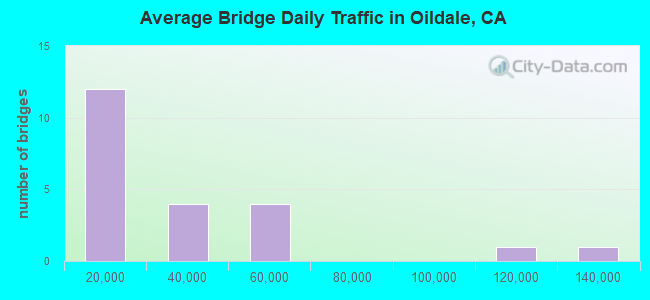
- 651,685Total average daily traffic
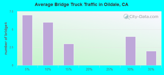
- 132,940Total average daily truck traffic
- National Bridge Inventory (NBI) Registered Bridges for Oildale
- No street view available for this location
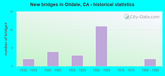
- New bridges - historical statistics
- 21930-1939
- 41940-1949
- 31950-1959
- 111960-1969
- 21980-1989
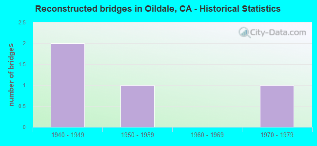
- Reconstructed bridges - Historical Statistics
- 21940-1949
- 11950-1959
- 01960-1969
- 11970-1979
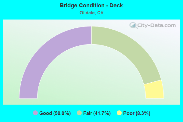
- Bridge Condition - Deck
- 50.0%Good
- 41.7%Fair
- 8.3%Poor
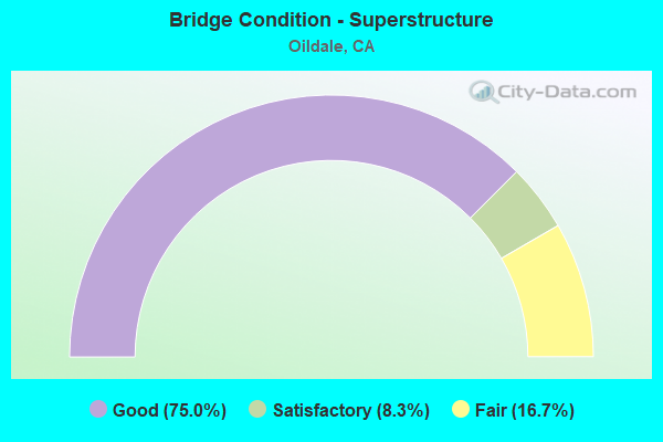
- Bridge Condition - Superstructure
- 75.0%Good
- 8.3%Satisfactory
- 16.7%Fair
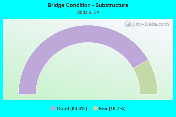
- Bridge Condition - Substructure
- 83.3%Good
- 16.7%Fair
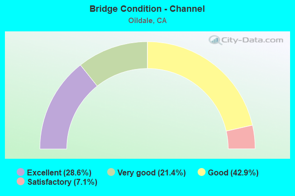
- Bridge Condition - Channel
- 28.6%Excellent
- 21.4%Very good
- 42.9%Good
- 7.1%Satisfactory
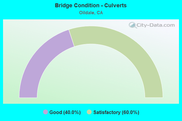
- Bridge Condition - Culverts
- 40.0%Good
- 60.0%Satisfactory
Find on map >> Show street view
Structure Number: 50 0034L, Location: 06-KER-099-R28.56 (Lat: 35.420886, Lng: -119.060936), Route carried "on" structure: State highway 99, Year Built: 1964, Status: Open, Structure Length: 10.70m (35.10ft), Average Daily Traffic: 45,000 (year 2019), Truck Traffic: 30%, Average Future Daily Traffic: 60,508 (year 2039), Design Load: HS 20, Features Intersected: NORRIS RD, UP RR,OILDALE
Minimum Vertical Clearance: 30+ m (98+ ft), Kilometerpoint: 28.560, Lanes on structure: 3, Lanes under structure: 2, Base Highway Network: Yes (, Subroute: 1), Owner: State Highway Agency, Approaching Roadway Width: 14.0m (45.9ft), Skew: 5 degrees, Material/Design: Concrete continuous, Design/Construction: Box Beam or Girders - Multiple, Number Of Spans In Main Unit: 5, Length of Maximum Span: 26.5m (86.9ft), Curb-To-Curb Width: 14.9m (48.9ft), Out-to-Out Width: 15.7m (51.5ft)
Condition: Deck: Good, Superstructure: Good, Substructure: Good, Operating Rating: 43.4 metric tons, Method Used To Determine Operating Rating: Load and Resistance Factor Rating (LRFR) rating reported by rating factor(RF) method using HL-93 loadings, Inventory Rating: 31.1 metric tons, Method Used To Determine Inventory Rating: Load and Resistance Factor Rating (LRFR) rating reported by rating factor(RF) method using HL-93 loadings, Structural Evaluation: Better than present minimum criteria, Deck Geometry: Meets minimum limits, Underclear: Better than present minimum criteria, Approach Roadway Alignment: Equal to present desirable criteria, Designated Inspection Frequency: Every 24 months, Inspection Date: October 2021, Deck Structure Type: Concrete Cast-file-Place
Find on map >> Show street view
Structure Number: 50 0034R, Location: 06-KER-099-R28.56 (Lat: 35.420619, Lng: -119.060572), Route carried "on" structure: State highway 99, Year Built: 1964, Status: Open, Structure Length: 10.70m (35.10ft), Average Daily Traffic: 45,000 (year 2019), Truck Traffic: 30%, Average Future Daily Traffic: 60,508 (year 2039), Design Load: HS 20, Features Intersected: NORRIS RD, UP RR,OILDALE
Minimum Vertical Clearance: 30+ m (98+ ft), Kilometerpoint: 28.560, Lanes on structure: 3, Lanes under structure: 2, Base Highway Network: Yes (, Subroute: 1), Owner: State Highway Agency, Approaching Roadway Width: 14.0m (45.9ft), Skew: 5 degrees, Material/Design: Concrete continuous, Design/Construction: Box Beam or Girders - Multiple, Number Of Spans In Main Unit: 5, Length of Maximum Span: 26.5m (86.9ft), Curb-To-Curb Width: 14.9m (48.9ft), Out-to-Out Width: 15.7m (51.5ft)
Condition: Deck: Good, Superstructure: Good, Substructure: Good, Operating Rating: 51.2 metric tons, Method Used To Determine Operating Rating: Load and Resistance Factor Rating (LRFR) rating reported by rating factor(RF) method using HL-93 loadings, Inventory Rating: 36.6 metric tons, Method Used To Determine Inventory Rating: Load and Resistance Factor Rating (LRFR) rating reported by rating factor(RF) method using HL-93 loadings, Structural Evaluation: Better than present minimum criteria, Deck Geometry: Meets minimum limits, Underclear: High priority of corrective action, Approach Roadway Alignment: Equal to present desirable criteria, Designated Inspection Frequency: Every 24 months, Inspection Date: October 2021, Deck Structure Type: Concrete Cast-file-Place
Find on map >> Show street view
Structure Number: 50 0050L, Location: 06-KER-099-R28.39 (Lat: 35.418542, Lng: -119.060314), Route carried "on" structure: State highway 99, Year Built: 1964, Status: Open, Structure Length: 3.99m (13.09ft), Average Daily Traffic: 55,000 (year 2019), Truck Traffic: 28%, Average Future Daily Traffic: 78,757 (year 2039), Design Load: HS 20, Features Intersected: BEARDSLEY CANAL
Minimum Vertical Clearance: 30+ m (98+ ft), Kilometerpoint: 28.390, Lanes on structure: 3, Base Highway Network: Yes (, Subroute: 1), Owner: State Highway Agency, Approaching Roadway Width: 14.9m (48.9ft), Skew: 3 degrees, Material/Design: Prestressed concrete, Design/Construction: Stringer/Multi-beam, Number Of Spans In Main Unit: 1, Number Of Approach Spans: 2, Length of Maximum Span: 21.0m (68.9ft), Curb-To-Curb Width: 14.9m (48.9ft), Out-to-Out Width: 15.7m (51.5ft)
Condition: Deck: Good, Superstructure: Good, Substructure: Good, Channel: Excellent, Operating Rating: 37.9 metric tons, Method Used To Determine Operating Rating: Load and Resistance Factor Rating (LRFR) rating reported by rating factor(RF) method using HL-93 loadings, Inventory Rating: 24.9 metric tons, Method Used To Determine Inventory Rating: Load and Resistance Factor Rating (LRFR) rating reported by rating factor(RF) method using HL-93 loadings, Structural Evaluation: Equal to present minimum criteria, Deck Geometry: Meets minimum limits, Waterway Adequacy: Superior to present desirable criteria, Approach Roadway Alignment: Equal to present desirable criteria, Designated Inspection Frequency: Every 24 months, Inspection Date: October 2021, Deck Structure Type: Concrete Cast-file-Place
Find on map >> Show street view
Structure Number: 50 0050R, Location: 06-KER-099-R28.39 (Lat: 35.418450, Lng: -119.059989), Route carried "on" structure: State highway 99, Year Built: 1964, Status: Open, Structure Length: 3.99m (13.09ft), Average Daily Traffic: 55,000 (year 2019), Truck Traffic: 28%, Average Future Daily Traffic: 78,757 (year 2039), Design Load: HS 20, Features Intersected: BEARDSLEY CANAL
Minimum Vertical Clearance: 30+ m (98+ ft), Kilometerpoint: 28.390, Lanes on structure: 3, Base Highway Network: Yes (, Subroute: 1), Owner: State Highway Agency, Approaching Roadway Width: 14.0m (45.9ft), Skew: 3 degrees, Material/Design: Prestressed concrete, Design/Construction: Stringer/Multi-beam, Number Of Spans In Main Unit: 1, Number Of Approach Spans: 2, Length of Maximum Span: 21.0m (68.9ft), Curb-To-Curb Width: 14.9m (48.9ft), Out-to-Out Width: 15.7m (51.5ft)
Condition: Deck: Fair, Superstructure: Good, Substructure: Good, Channel: Excellent, Operating Rating: 57.3 metric tons, Method Used To Determine Operating Rating: Load and Resistance Factor Rating (LRFR) rating reported by rating factor(RF) method using HL-93 loadings, Inventory Rating: 24.9 metric tons, Method Used To Determine Inventory Rating: Load and Resistance Factor Rating (LRFR) rating reported by rating factor(RF) method using HL-93 loadings, Structural Evaluation: Equal to present minimum criteria, Deck Geometry: Meets minimum limits, Waterway Adequacy: Superior to present desirable criteria, Approach Roadway Alignment: Equal to present desirable criteria, Designated Inspection Frequency: Every 24 months, Inspection Date: October 2021, Deck Structure Type: Concrete Cast-file-Place, Wearing Surface/Protective System: Wearing Surface: Bituminous
Find on map >> Show street view
Structure Number: 50 0051, Location: 06-KER-099-27.80 (Lat: 35.411700, Lng: -119.053867), Route carried "on" structure: State highway 99, Year Built: 1933, Year Reconstructed: 1964, Status: Open, Structure Length: 1.01m (3.31ft), Average Daily Traffic: 130,000 (year 2018), Truck Traffic: 28%, Average Future Daily Traffic: 157,515 (year 2039), Features Intersected: CANAL LATERAL 29
Minimum Vertical Clearance: 30+ m (98+ ft), Kilometerpoint: 27.800, Lanes on structure: 9, Base Highway Network: Yes (, Subroute: 1), Owner: State Highway Agency, Approaching Roadway Width: 55.5m (182.1ft), Skew: 32 degrees, Material/Design: Concrete continuous, Design/Construction: Culvert, Number Of Spans In Main Unit: 2, Length of Maximum Span: 4.9m (16.1ft), Curb-To-Curb Width: 55.5m (182.1ft), Out-to-Out Width: 61.5m (201.8ft)
Condition: Channel: Very good, Culverts: Good, Operating Rating: 40.5 metric tons, Method Used To Determine Operating Rating: Field evaluation and documented engineering judgment, Inventory Rating: 24.3 metric tons, Method Used To Determine Inventory Rating: Field evaluation and documented engineering judgment, Structural Evaluation: Equal to present minimum criteria, Deck Geometry: Superior to present desirable criteria, Waterway Adequacy: Superior to present desirable criteria, Approach Roadway Alignment: Equal to present desirable criteria, Designated Inspection Frequency: Every 24 months, Inspection Date: October 2021, Deck Structure Type: Concrete Cast-file-Place
Find on map >> Show street view
Structure Number: 50 0209, Location: 06-KER-204-5.90 (Lat: 35.397089, Lng: -119.032761), Route carried "on" structure: State highway 204, Year Built: 1933, Year Reconstructed: 1954, Status: Open, Structure Length: 4.33m (14.21ft), Average Daily Traffic: 38,000 (year 2009), Truck Traffic: 6%, Average Future Daily Traffic: 77,877 (year 2043), Features Intersected: CALLOWAY CANAL
Minimum Vertical Clearance: 30+ m (98+ ft), Kilometerpoint: 5.900, Lanes on structure: 4, Base Highway Network: Yes (Inventory Route: 2, Subroute: 1), Owner: State Highway Agency, Approaching Roadway Width: 22.3m (73.2ft), Skew: 30 degrees, Material/Design: Steel, Design/Construction: Stringer/Multi-beam, Number Of Spans In Main Unit: 4, Length of Maximum Span: 10.7m (35.1ft), Curb or Sidewalk Widths: Left: 1.2m (3.9ft), Right: 1.2m (3.9ft), Curb-To-Curb Width: 17.7m (58.1ft), Out-to-Out Width: 21.5m (70.5ft)
Condition: Deck: Good, Superstructure: Good, Substructure: Good, Channel: Good, Operating Rating: 36.9 metric tons, Method Used To Determine Operating Rating: Load Factor (LF), Inventory Rating: 22.0 metric tons, Method Used To Determine Inventory Rating: Load Factor (LF), Structural Evaluation: Somewhat better than minimum adequacy, Deck Geometry: Meets minimum limits, Waterway Adequacy: Equal to present desirable criteria, Approach Roadway Alignment: Equal to present minimum criteria, Designated Inspection Frequency: Every 24 months, Inspection Date: December 2021, Deck Structure Type: Concrete Cast-file-Place, Wearing Surface/Protective System: Wearing Surface: Bituminous
Find on map >> Show street view
Structure Number: 50C0015, Location: 0.1 MI S OF OLIVE DR (Lat: 35.410733, Lng: -119.038836), Route carried "on" structure: County highway , Year Built: 1951, Status: Open, Structure Length: 1.37m (4.49ft), Average Daily Traffic: 25,500 (year 2007), Truck Traffic: 2%, Average Future Daily Traffic: 26,810 (year 2038), Design Load: HS 20, Features Intersected: BEARDSLEY CANAL, Facility Carried by Structure: AIRPORT DRIVE
Minimum Vertical Clearance: 30+ m (98+ ft), Kilometerpoint: 0.000, Lanes on structure: 4, Base Highway Network: Yes, Owner: County Highway Agency, Approaching Roadway Width: 23.2m (76.1ft), Skew: 20 degrees, Material/Design: Concrete continuous, Design/Construction: Slab, Number Of Spans In Main Unit: 2, Length of Maximum Span: 6.7m (22.0ft), Curb-To-Curb Width: 19.5m (64.0ft), Out-to-Out Width: 24.0m (78.7ft)
Condition: Deck: Fair, Superstructure: Fair, Substructure: Fair, Channel: Excellent, Operating Rating: 47.3 metric tons, Method Used To Determine Operating Rating: Load Factor (LF), Inventory Rating: 28.5 metric tons, Method Used To Determine Inventory Rating: Load Factor (LF), Structural Evaluation: Somewhat better than minimum adequacy, Deck Geometry: Better than present minimum criteria, Waterway Adequacy: Superior to present desirable criteria, Approach Roadway Alignment: Equal to present minimum criteria, Designated Inspection Frequency: Every 24 months, Inspection Date: November 2020, Deck Structure Type: Concrete Cast-file-Place
Find on map >> Show street view
Structure Number: 50C0022, Location: S/O FERGUSON AVENUE (Lat: 35.415750, Lng: -119.012644), Route carried "on" structure: County highway , Year Built: 1956, Year Reconstructed: 1970, Status: Open, Structure Length: 1.58m (5.18ft), Average Daily Traffic: 9,675 (year 2010), Truck Traffic: 1%, Average Future Daily Traffic: 32,172 (year 2036), Design Load: HS 20, Features Intersected: BEARDSLEY CANAL, Facility Carried by Structure: MANOR STREET
Minimum Vertical Clearance: 30+ m (98+ ft), Kilometerpoint: 0.000, Lanes on structure: 4, Base Highway Network: Yes, Owner: County Highway Agency, Approaching Roadway Width: 26.2m (86.0ft), Skew: 32 degrees, Material/Design: Steel, Design/Construction: Stringer/Multi-beam, Number Of Spans In Main Unit: 1, Length of Maximum Span: 15.2m (49.9ft), Curb or Sidewalk Widths: Left: 1.2m (3.9ft), Right: 1.2m (3.9ft), Curb-To-Curb Width: 17.6m (57.7ft), Out-to-Out Width: 25.3m (83.0ft)
Condition: Deck: Good, Superstructure: Good, Substructure: Good, Channel: Good, Operating Rating: 18.8 metric tons, Method Used To Determine Operating Rating: Load and Resistance Factor Rating (LRFR) rating reported by rating factor(RF) method using HL-93 loadings, Inventory Rating: 14.3 metric tons, Method Used To Determine Inventory Rating: Load and Resistance Factor Rating (LRFR) rating reported by rating factor(RF) method using HL-93 loadings, Structural Evaluation: High priority of corrective action, Deck Geometry: Somewhat better than minimum adequacy, Waterway Adequacy: Equal to present desirable criteria, Approach Roadway Alignment: Equal to present desirable criteria, Designated Inspection Frequency: Every 48 months, Other Special Inspection Frequency: Every 48 months, Inspection Date: November 2018, Other Special Inspection Date: November 2018, Deck Structure Type: Concrete Cast-file-Place, Wearing Surface/Protective System: Wearing Surface: Bituminous
Find on map >> Show street view
Structure Number: 50C007, Location: 0.2 MI S/O NORRIS RD (Lat: 35.418769, Lng: -119.060758), Route carried "on" structure: County highway , Year Built: 1947, Status: Open, Structure Length: 2.99m (9.81ft), Average Daily Traffic: 4,300 (year 2005), Truck Traffic: 10%, Average Future Daily Traffic: 7,210 (year 2042), Features Intersected: BEARDSLEY CANAL, Facility Carried by Structure: KNUDSEN DRIVE
Minimum Vertical Clearance: 30+ m (98+ ft), Kilometerpoint: 0.000, Lanes on structure: 2, Owner: County Highway Agency, Approaching Roadway Width: 7.0m (23.0ft), Skew: 3 degrees, Material/Design: Concrete continuous, Design/Construction: Slab, Number Of Spans In Main Unit: 3, Length of Maximum Span: 9.8m (32.2ft), Curb or Sidewalk Widths: Left: 0.6m (2.0ft), Right: 0.6m (2.0ft), Curb-To-Curb Width: 8.3m (27.2ft), Out-to-Out Width: 10.1m (33.1ft)
Condition: Deck: Fair, Superstructure: Fair, Substructure: Fair, Channel: Very good, Operating Rating: 59.6 metric tons, Method Used To Determine Operating Rating: Load Factor (LF), Inventory Rating: 35.6 metric tons, Method Used To Determine Inventory Rating: Load Factor (LF), Structural Evaluation: Somewhat better than minimum adequacy, Deck Geometry: High priority of corrective action, Waterway Adequacy: Equal to present minimum criteria, Approach Roadway Alignment: Equal to present minimum criteria, Designated Inspection Frequency: Every 24 months, Inspection Date: November 2020, Deck Structure Type: Concrete Cast-file-Place
Find on map >> Show street view
Structure Number: 50C0071, Location: 0.25 MI N OF NORRIS RD W (Lat: 35.421086, Lng: -119.061406), Route carried "on" structure: County highway , Year Built: 1948, Status: Open, Structure Length: 14.90m (48.88ft), Average Daily Traffic: 4,000 (year 2005), Truck Traffic: 10%, Average Future Daily Traffic: 8,723 (year 2042), Design Load: HS 20, Features Intersected: UP RR & GOLDEN STATE HWY, Facility Carried by Structure: KNUDSEN DRIVE
Minimum Vertical Clearance: 30+ m (98+ ft), Kilometerpoint: 0.000, Lanes on structure: 2, Lanes under structure: 2, Owner: County Highway Agency, Approaching Roadway Width: 7.0m (23.0ft), Skew: 5 degrees, Material/Design: Steel continuous, Design/Construction: Stringer/Multi-beam, Number Of Spans In Main Unit: 9, Length of Maximum Span: 18.6m (61.0ft), Curb or Sidewalk Widths: Left: 0.6m (2.0ft), Right: 0.6m (2.0ft), Curb-To-Curb Width: 8.2m (26.9ft), Out-to-Out Width: 10.0m (32.8ft)
Condition: Deck: Poor, Superstructure: Satisfactory, Substructure: Good, Operating Rating: 53.5 metric tons, Method Used To Determine Operating Rating: Allowable Stress (AS), Inventory Rating: 36.3 metric tons, Method Used To Determine Inventory Rating: Allowable Stress (AS), Structural Evaluation: Equal to present minimum criteria, Deck Geometry: High priority of corrective action, Underclear: High priority of replacement, Approach Roadway Alignment: Equal to present minimum criteria, Length Of Structure Improvement: 14.90m (48.88ft), Designated Inspection Frequency: Every 24 months, Critical Feature Inspection Frequency: Every 24 months, Inspection Date: November 2020, Critical Feature Inspection Date: September 2020, Bridge Improvement Cost: $3,427,000, Roadway Improvement Cost: $685,000, Total Project Cost: $5,757,000 ( Estimate for 2017), Deck Structure Type: Concrete Cast-file-Place
Find on map >> Show street view
Structure Number: 50C0082, Location: SOUTH OF DECATUR DRIVE (Lat: 35.413131, Lng: -119.020958), Route carried "on" structure: County highway , Year Built: 1941, Year Reconstructed: 1954, Status: Open, Structure Length: 3.11m (10.20ft), Average Daily Traffic: 15,000 (year 2007), Truck Traffic: 5%, Average Future Daily Traffic: 34,591 (year 2042), Design Load: H 20, Features Intersected: BEARDSLEY CANAL, Facility Carried by Structure: N CHESTER AVE
Minimum Vertical Clearance: 30+ m (98+ ft), Kilometerpoint: 0.000, Lanes on structure: 5, Base Highway Network: Yes, Owner: County Highway Agency, Approaching Roadway Width: 32.4m (106.3ft), Skew: 22 degrees, Material/Design: Concrete continuous, Design/Construction: Slab, Number Of Spans In Main Unit: 6, Length of Maximum Span: 7.0m (23.0ft), Curb or Sidewalk Widths: Left: 1.5m (4.9ft), Right: 1.5m (4.9ft), Curb-To-Curb Width: 28.1m (92.2ft), Out-to-Out Width: 32.4m (106.3ft)
Condition: Deck: Good, Superstructure: Good, Substructure: Good, Channel: Excellent, Operating Rating: 36.3 metric tons, Method Used To Determine Operating Rating: Load Factor (LF), Inventory Rating: 21.7 metric tons, Method Used To Determine Inventory Rating: Load Factor (LF), Structural Evaluation: Somewhat better than minimum adequacy, Deck Geometry: Superior to present desirable criteria, Waterway Adequacy: Superior to present desirable criteria, Approach Roadway Alignment: Equal to present minimum criteria, Designated Inspection Frequency: Every 24 months, Inspection Date: November 2020, Deck Structure Type: Concrete Cast-file-Place, Wearing Surface/Protective System: Wearing Surface: Bituminous
Find on map >> Show street view
Structure Number: 50C0131, Location: EAST OF STATE RD (Lat: 35.412189, Lng: -119.052378), Route carried "on" structure: City street , Year Built: 1969, Status: Open, Structure Length: 0.76m (2.49ft), Average Daily Traffic: 20,000 (year 2007), Truck Traffic: 5%, Average Future Daily Traffic: 33,371 (year 2042), Features Intersected: CANAL LATERAL 29, Facility Carried by Structure: OLIVE DRIVE
Minimum Vertical Clearance: 30+ m (98+ ft), Kilometerpoint: 0.000, Lanes on structure: 5, Owner: County Highway Agency, Approaching Roadway Width: 26.8m (87.9ft), Skew: 23 degrees, Material/Design: Concrete continuous, Design/Construction: Culvert, Number Of Spans In Main Unit: 2, Length of Maximum Span: 3.7m (12.1ft), Curb or Sidewalk Widths: Left: 0.3m (1.0ft), Right: 0.2m (0.7ft), Curb-To-Curb Width: 24.4m (80.1ft), Out-to-Out Width: 31.4m (103.0ft)
Condition: Channel: Good, Culverts: Satisfactory, Operating Rating: 40.5 metric tons, Method Used To Determine Operating Rating: Field evaluation and documented engineering judgment, Inventory Rating: 24.3 metric tons, Method Used To Determine Inventory Rating: Field evaluation and documented engineering judgment, Structural Evaluation: Equal to present minimum criteria, Deck Geometry: Superior to present desirable criteria, Waterway Adequacy: Better than present minimum criteria, Approach Roadway Alignment: Equal to present minimum criteria, Designated Inspection Frequency: Every 24 months, Inspection Date: November 2020, Deck Structure Type: Concrete Cast-file-Place, Wearing Surface/Protective System: Wearing Surface: Bituminous
Find on map >> Show street view
Structure Number: 50C0132, Location: 0.1 MI W AIRPORT DR (Lat: 35.412167, Lng: -119.041050), Route carried "on" structure: County highway , Year Built: 1968, Status: Open, Structure Length: 2.62m (8.60ft), Average Daily Traffic: 13,000 (year 2007), Truck Traffic: 5%, Average Future Daily Traffic: 21,136 (year 2042), Features Intersected: BEARDSLEY CANAL, Facility Carried by Structure: OLIVE DRIVE
Minimum Vertical Clearance: 30+ m (98+ ft), Kilometerpoint: 0.000, Lanes on structure: 4, Owner: County Highway Agency, Approaching Roadway Width: 20.7m (67.9ft), Skew: 4 degrees, Material/Design: Concrete continuous, Design/Construction: Culvert, Number Of Spans In Main Unit: 3, Length of Maximum Span: 3.4m (11.2ft), Curb or Sidewalk Widths: Left: 2.4m (7.9ft), Right: 2.4m (7.9ft), Curb-To-Curb Width: 20.7m (67.9ft), Out-to-Out Width: 26.3m (86.3ft)
Condition: Channel: Good, Culverts: Satisfactory, Operating Rating: 40.5 metric tons, Method Used To Determine Operating Rating: Field evaluation and documented engineering judgment, Inventory Rating: 24.3 metric tons, Method Used To Determine Inventory Rating: Field evaluation and documented engineering judgment, Structural Evaluation: Equal to present minimum criteria, Deck Geometry: Superior to present desirable criteria, Waterway Adequacy: Equal to present desirable criteria, Approach Roadway Alignment: Equal to present minimum criteria, Designated Inspection Frequency: Every 24 months, Inspection Date: November 2020, Deck Structure Type: Concrete Cast-file-Place, Wearing Surface/Protective System: Wearing Surface: Bituminous
Find on map >> Show street view
Structure Number: 50C0143, Location: NORTH OF OLIVE DRIVE (Lat: 35.412828, Lng: -119.048758), Route carried "on" structure: County highway , Year Built: 1968, Status: Open, Structure Length: 0.79m (2.59ft), Average Daily Traffic: 9,000 (year 2007), Truck Traffic: 5%, Average Future Daily Traffic: 15,572 (year 2042), Features Intersected: BEARDSLEY CANAL, Facility Carried by Structure: ROBERTS LANE
Minimum Vertical Clearance: 30+ m (98+ ft), Kilometerpoint: 0.000, Lanes on structure: 4, Owner: County Highway Agency, Approaching Roadway Width: 19.8m (65.0ft), Skew: 32 degrees, Material/Design: Concrete continuous, Design/Construction: Culvert, Number Of Spans In Main Unit: 3, Length of Maximum Span: 2.4m (7.9ft), Curb or Sidewalk Widths: Left: 1.2m (3.9ft), Right: 1.7m (5.6ft), Curb-To-Curb Width: 17.1m (56.1ft), Out-to-Out Width: 28.7m (94.2ft)
Condition: Channel: Good, Culverts: Satisfactory, Operating Rating: 40.5 metric tons, Method Used To Determine Operating Rating: Field evaluation and documented engineering judgment, Inventory Rating: 24.3 metric tons, Method Used To Determine Inventory Rating: Field evaluation and documented engineering judgment, Structural Evaluation: Equal to present minimum criteria, Deck Geometry: Somewhat better than minimum adequacy, Waterway Adequacy: Equal to present desirable criteria, Approach Roadway Alignment: Equal to present minimum criteria, Designated Inspection Frequency: Every 24 months, Inspection Date: November 2020, Deck Structure Type: Concrete Cast-file-Place, Wearing Surface/Protective System: Wearing Surface: Bituminous
Find on map >> Show street view
Structure Number: 50C0144, Location: 0.04 MI S OF DECATUR DR (Lat: 35.412889, Lng: -119.029922), Route carried "on" structure: County highway , Year Built: 1981, Status: Open, Structure Length: 1.71m (5.61ft), Average Daily Traffic: 5,300 (year 2007), Truck Traffic: 2%, Average Future Daily Traffic: 8,900 (year 2042), Design Load: HS 20+Mod, Features Intersected: BEARDSLEY CANAL, Facility Carried by Structure: OILDALE DRIVE
Minimum Vertical Clearance: 30+ m (98+ ft), Kilometerpoint: 0.000, Lanes on structure: 2, Owner: County Highway Agency, Approaching Roadway Width: 13.4m (44.0ft), Material/Design: Prestressed concrete, Design/Construction: Tee Beam, Number Of Spans In Main Unit: 1, Length of Maximum Span: 16.5m (54.1ft), Curb or Sidewalk Widths: Left: 1.5m (4.9ft), Right: 1.5m (4.9ft), Curb-To-Curb Width: 13.4m (44.0ft), Out-to-Out Width: 17.1m (56.1ft)
Condition: Deck: Fair, Superstructure: Good, Substructure: Good, Channel: Very good, Operating Rating: 35.0 metric tons, Method Used To Determine Operating Rating: Load and Resistance Factor Rating (LRFR) rating reported by rating factor(RF) method using HL-93 loadings, Inventory Rating: 23.0 metric tons, Method Used To Determine Inventory Rating: Load and Resistance Factor Rating (LRFR) rating reported by rating factor(RF) method using HL-93 loadings, Structural Evaluation: Somewhat better than minimum adequacy, Deck Geometry: Equal to present minimum criteria, Waterway Adequacy: Equal to present desirable criteria, Approach Roadway Alignment: Equal to present minimum criteria, Designated Inspection Frequency: Every 24 months, Inspection Date: November 2020, Deck Structure Type: Concrete Cast-file-Place
Find on map >> Show street view
Structure Number: 50C0281, Location: 0.06 MI S FERGUSON AVE (Lat: 35.414581, Lng: -119.016522), Route carried "on" structure: County highway , Year Built: 1981, Status: Open, Structure Length: 1.80m (5.91ft), Average Daily Traffic: 310 (year 2014), Truck Traffic: 1%, Average Future Daily Traffic: 524 (year 2038), Design Load: HS 20+Mod, Features Intersected: BEARDSLEY CANAL, Facility Carried by Structure: IRIS STREET
Minimum Vertical Clearance: 30+ m (98+ ft), Kilometerpoint: 0.000, Lanes on structure: 2, Owner: County Highway Agency, Approaching Roadway Width: 7.6m (24.9ft), Skew: 2 degrees, Material/Design: Prestressed concrete, Design/Construction: Tee Beam, Number Of Spans In Main Unit: 1, Length of Maximum Span: 17.4m (57.1ft), Curb or Sidewalk Widths: Left: 1.5m (4.9ft), Right: 1.5m (4.9ft), Curb-To-Curb Width: 12.2m (40.0ft), Out-to-Out Width: 16.6m (54.5ft)
Condition: Deck: Fair, Superstructure: Good, Substructure: Good, Channel: Good, Operating Rating: 66.4 metric tons, Method Used To Determine Operating Rating: Load Factor (LF), Inventory Rating: 32.4 metric tons, Method Used To Determine Inventory Rating: Load Factor (LF), Structural Evaluation: Better than present minimum criteria, Deck Geometry: Superior to present desirable criteria, Waterway Adequacy: Equal to present desirable criteria, Approach Roadway Alignment: Equal to present minimum criteria, Designated Inspection Frequency: Every 24 months, Inspection Date: December 2020, Deck Structure Type: Concrete Cast-file-Place
Find on map >> Show street view
Structure Number: 50C0293, Location: SOUTH OF OLIVE DRIVE (Lat: 35.411894, Lng: -119.052747), Route carried "on" structure: County highway , Year Built: 1965, Status: Open, Structure Length: 0.67m (2.20ft), Average Daily Traffic: 3,500 (year 2016), Truck Traffic: 5%, Average Future Daily Traffic: 4,500 (year 2038), Features Intersected: CANAL LATERAL 29, Facility Carried by Structure: STATE ROAD
Minimum Vertical Clearance: 30+ m (98+ ft), Kilometerpoint: 0.000, Lanes on structure: 3, Owner: County Highway Agency, Approaching Roadway Width: 13.5m (44.3ft), Material/Design: Concrete continuous, Design/Construction: Culvert, Number Of Spans In Main Unit: 2, Length of Maximum Span: 3.0m (9.8ft), Curb or Sidewalk Widths: Left: 1.7m (5.6ft), Right: 1.9m (6.2ft)
Condition: Channel: Satisfactory, Culverts: Good, Operating Rating: 40.5 metric tons, Method Used To Determine Operating Rating: Field evaluation and documented engineering judgment, Inventory Rating: 24.3 metric tons, Method Used To Determine Inventory Rating: Field evaluation and documented engineering judgment, Structural Evaluation: Equal to present minimum criteria, Waterway Adequacy: Better than present minimum criteria, Approach Roadway Alignment: Equal to present minimum criteria, Designated Inspection Frequency: Every 24 months, Inspection Date: December 2020
Find on map >> Show street view
Structure Number: 50 0034L, Location: 06-KER-099-R28.56 (Lat: 35.420886, Lng: -119.060936), Route carried "under" structure: County highway , Year Built: 1964, Structure Length: 0. m, Average Daily Traffic: 14,000 (year 2017), Truck Traffic: 1%, Features Intersected: NORRIS RD, UP RR,OILDALE, Facility Carried by Structure: STATE ROUTE 99 SB
Minimum Vertical Clearance: 6.42m (21.06ft), Kilometerpoint: 0.000, Lanes on structure: 3, Lanes under structure: 2, Material/Design: Concrete continuous, Design/Construction: Box Beam or Girders - Multiple, Length of Maximum Span: 26.5m (86.9ft)
Find on map >> Show street view
Structure Number: 50 0034R, Location: 06-KER-099-R28.56 (Lat: 35.420619, Lng: -119.060572), Route carried "under" structure: County highway , Year Built: 1964, Structure Length: 0. m, Average Daily Traffic: 14,000 (year 2017), Truck Traffic: 1%, Features Intersected: NORRIS RD, UP RR,OILDALE, Facility Carried by Structure: STATE ROUTE 99 NB
Minimum Vertical Clearance: 7.79m (25.56ft), Kilometerpoint: 0.000, Lanes on structure: 3, Lanes under structure: 2, Material/Design: Concrete continuous, Design/Construction: Box Beam or Girders - Multiple, Length of Maximum Span: 26.5m (86.9ft)
Find on map >> Show street view
Structure Number: 50 0049, Location: 06-KER-099-27.32 (Lat: 35.406278, Lng: -119.048569), Route carried "under" structure: State highway 99, Year Built: 1963, Structure Length: 0. m, Average Daily Traffic: 110,000 (year 2018), Truck Traffic: 28%, Features Intersected: STATE ROUTE 99, Facility Carried by Structure: SJVR & BNSF RY
Minimum Vertical Clearance: 4.62m (15.16ft), Kilometerpoint: 27.320, Lanes under structure: 6, Material/Design: Steel, Design/Construction: Girder and Floorbeam System, Length of Maximum Span: 26.8m (87.9ft)
Find on map >> Show street view
Structure Number: 50C0014, Location: E OF SR 204 (Lat: 35.404931, Lng: -119.039456), Route carried "under" structure: County highway , Year Built: 1952, Structure Length: 0. m, Average Daily Traffic: 35,000 (year 2007), Truck Traffic: 2%, Features Intersected: AIRPORT DRIVE, Facility Carried by Structure: UP RR
Minimum Vertical Clearance: 4.70m (15.42ft), Kilometerpoint: 0.000, Lanes under structure: 4, Material/Design: Steel, Design/Construction: Stringer/Multi-beam, Length of Maximum Span: 11.6m (38.1ft)
Find on map >> Show street view
Structure Number: 50C0071, Location: 0.25 MI N OF NORRIS RD W (Lat: 35.421086, Lng: -119.061406), Route carried "under" structure: County highway , Year Built: 1948, Structure Length: 0. m, Average Daily Traffic: 1,100 (year 2005), Truck Traffic: 10%, Features Intersected: UP RR & GOLDEN STATE HWY, Facility Carried by Structure: KNUDSEN DRIVE
Minimum Vertical Clearance: 6.55m (21.49ft), Kilometerpoint: 0.000, Lanes on structure: 2, Lanes under structure: 2, Material/Design: Steel continuous, Design/Construction: Stringer/Multi-beam, Length of Maximum Span: 18.6m (61.0ft)