Bridge Statistics for Ogden, Illinois (IL)
Condition, Traffic, Stress, Structural Evaluation, Project Costs
- National Bridge Inventory (NBI) Statistics
- 11Number of bridges
- 72ft / 22.1mTotal length
- 56,575Total average daily traffic
- 16,269Total average daily truck traffic
- National Bridge Inventory (NBI) Registered Bridges for Ogden
- No street view available for this location
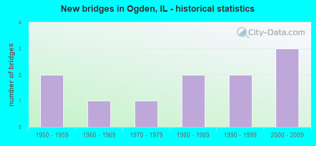
- New bridges - historical statistics
- 21950-1959
- 11960-1969
- 11970-1979
- 21980-1989
- 21990-1999
- 32000-2009


- Bridge Condition - Deck
- 42.9%Good
- 57.1%Satisfactory

- Bridge Condition - Superstructure
- 42.9%Good
- 57.1%Satisfactory

- Bridge Condition - Substructure
- 28.6%Very good
- 28.6%Good
- 28.6%Satisfactory
- 14.3%Fair

- Bridge Condition - Channel
- 57.1%Very good
- 14.3%Good
- 28.6%Satisfactory
Find on map >> Show street view
Structure Number: 100095, Location: 3.5 MI S OF ROYAL (Lat: 40.142025, Lng: -87.959828), Route carried "on" structure: County highway , Year Built: 1963, Status: Open, Structure Length: 0.84m (2.76ft), Average Daily Traffic: 600 (year 2020), Truck Traffic: 13%, Average Future Daily Traffic: 959 (year 2032), Design Load: HS 15, Features Intersected: STREAM, Facility Carried by Structure: FAS 518 (CH 22)
Minimum Vertical Clearance: 30+ m (98+ ft), Kilometerpoint: 5.649, Lanes on structure: 2, Owner: State Highway Agency, Approaching Roadway Width: 6.7m (22.0ft), Skew: 2 degrees, Material/Design: Concrete, Design/Construction: Slab, Number Of Spans In Main Unit: 1, Length of Maximum Span: 8.0m (26.2ft), Curb-To-Curb Width: 9.8m (32.2ft), Out-to-Out Width: 10.4m (34.1ft)
Condition: Deck: Satisfactory, Superstructure: Satisfactory, Substructure: Satisfactory, Channel: Good, Operating Rating: 49.2 metric tons, Method Used To Determine Operating Rating: Load Factor (LF) rating reported by rating factor (RF) method using MS18 loading, Inventory Rating: 29.5 metric tons, Method Used To Determine Inventory Rating: Load Factor (LF) rating reported by rating factor (RF) method using MS18 loading, Structural Evaluation: Equal to present minimum criteria, Deck Geometry: Equal to present minimum criteria, Waterway Adequacy: Equal to present desirable criteria, Approach Roadway Alignment: Equal to present desirable criteria, Designated Inspection Frequency: Every 24 months, Inspection Date: September 2021, Deck Structure Type: Concrete Cast-file-Place, Wearing Surface/Protective System: Wearing Surface: Bituminous
Find on map >> Show street view
Structure Number: 100277, Location: N EDGE OF OGDEN (Lat: 40.119703, Lng: -87.958828), Route carried "on" structure: Other road , Year Built: 2008, Status: Open, Structure Length: 6.68m (21.92ft), Average Daily Traffic: 1,950 (year 2020), Truck Traffic: 10%, Average Future Daily Traffic: 2,707 (year 2032), Design Load: HS 25 or greater, Features Intersected: I-74, Facility Carried by Structure: FAS 518 (CH 22)
Minimum Vertical Clearance: 30+ m (98+ ft), Kilometerpoint: 0.016, Lanes on structure: 2, Lanes under structure: 4, Base Highway Network: Yes, Owner: State Highway Agency, Approaching Roadway Width: 12.2m (40.0ft), Material/Design: Steel continuous, Design/Construction: Stringer/Multi-beam, Number Of Spans In Main Unit: 2, Length of Maximum Span: 33.0m (108.3ft), Curb-To-Curb Width: 12.2m (40.0ft), Out-to-Out Width: 13.2m (43.3ft)
Condition: Deck: Good, Superstructure: Good, Substructure: Good, Operating Rating: 77.1 metric tons, Method Used To Determine Operating Rating: Load Factor (LF) rating reported by rating factor (RF) method using MS18 loading, Inventory Rating: 46.3 metric tons, Method Used To Determine Inventory Rating: Load Factor (LF) rating reported by rating factor (RF) method using MS18 loading, Structural Evaluation: Better than present minimum criteria, Deck Geometry: Better than present minimum criteria, Underclear: Meets minimum limits, Approach Roadway Alignment: Equal to present desirable criteria, Designated Inspection Frequency: Every 24 months, Inspection Date: November 2020, Deck Structure Type: Concrete Cast-file-Place, Wearing Surface/Protective System: Deck Protection: Epoxy Coated Reinforcing
Find on map >> Show street view
Structure Number: 102023, Location: 0.5 MI N OF OGDEN (Lat: 40.127306, Lng: -87.958883), Route carried "on" structure: County highway , Year Built: 1992, Status: Open, Structure Length: 0.97m (3.18ft), Average Daily Traffic: 600 (year 2020), Truck Traffic: 13%, Average Future Daily Traffic: 959 (year 2032), Design Load: HS 20+Mod, Features Intersected: STREAM, Facility Carried by Structure: FAS 518(CH 22)
Minimum Vertical Clearance: 30+ m (98+ ft), Kilometerpoint: 7.290, Lanes on structure: 2, Owner: State Highway Agency, Approaching Roadway Width: 6.7m (22.0ft), Skew: 3 degrees, Material/Design: Concrete, Design/Construction: Culvert, Number Of Spans In Main Unit: 2, Length of Maximum Span: 4.2m (13.8ft)
Condition: Channel: Very good, Culverts: Good, Operating Rating: 61.2 metric tons, Method Used To Determine Operating Rating: Load Factor (LF) rating reported by rating factor (RF) method using MS18 loading, Inventory Rating: 36.9 metric tons, Method Used To Determine Inventory Rating: Load Factor (LF) rating reported by rating factor (RF) method using MS18 loading, Structural Evaluation: Better than present minimum criteria, Waterway Adequacy: Equal to present desirable criteria, Approach Roadway Alignment: Equal to present desirable criteria, Designated Inspection Frequency: Every 48 months, Inspection Date: September 2021
Find on map >> Show street view
Structure Number: 104055, Location: 1 MI NE OGDEN (Lat: 40.127200, Lng: -87.950028), Route carried "on" structure: County highway , Year Built: 1970, Status: Open, Structure Length: 0.94m (3.08ft), Average Daily Traffic: 150 (year 2021), Truck Traffic: 3%, Average Future Daily Traffic: 169 (year 2032), Design Load: HS 15, Features Intersected: STREAM, Facility Carried by Structure: TR 181 A
Minimum Vertical Clearance: 30+ m (98+ ft), Kilometerpoint: 14.886, Lanes on structure: 2, Owner: Town or Township Highway Agency, Approaching Roadway Width: 5.2m (17.1ft), Skew: 4 degrees, Material/Design: Concrete, Design/Construction: Culvert, Number Of Spans In Main Unit: 2, Length of Maximum Span: 4.3m (14.1ft), Curb-To-Curb Width: 7.3m (24.0ft), Out-to-Out Width: 7.7m (25.3ft)
Condition: Channel: Very good, Culverts: Good, Operating Rating: 32.4 metric tons, Method Used To Determine Operating Rating: Field evaluation and documented engineering judgment, Inventory Rating: 19.4 metric tons, Method Used To Determine Inventory Rating: Field evaluation and documented engineering judgment, Structural Evaluation: Somewhat better than minimum adequacy, Deck Geometry: Somewhat better than minimum adequacy, Waterway Adequacy: Equal to present desirable criteria, Approach Roadway Alignment: Better than present minimum criteria, Designated Inspection Frequency: Every 24 months, Inspection Date: Febuary 2020, Wearing Surface/Protective System: Wearing Surface: Gravel
Find on map >> Show street view
Structure Number: 104432, Location: 2 MI NW OF OGDEN (Lat: 40.131256, Lng: -87.977986), Route carried "on" structure: County highway , Year Built: 1994, Status: Open, Structure Length: 1.36m (4.46ft), Average Daily Traffic: 25 (year 2021), Average Future Daily Traffic: 67 (year 2032), Design Load: HS 20, Features Intersected: DRAINAGE DITCH, Facility Carried by Structure: TR 326 A
Minimum Vertical Clearance: 30+ m (98+ ft), Kilometerpoint: 1.191, Lanes on structure: 2, Owner: Town or Township Highway Agency, Approaching Roadway Width: 4.3m (14.1ft), Material/Design: Prestressed concrete, Design/Construction: Box Beam or Girders - Multiple, Number Of Spans In Main Unit: 1, Length of Maximum Span: 12.8m (42.0ft), Curb-To-Curb Width: 8.5m (27.9ft), Out-to-Out Width: 8.5m (27.9ft)
Condition: Deck: Good, Superstructure: Good, Substructure: Very good, Channel: Very good, Operating Rating: 44.1 metric tons, Method Used To Determine Operating Rating: Assigned rating based on Load Factor Design (LFD) reported by rating factor (RF) using MS18 loading, Inventory Rating: 32.4 metric tons, Method Used To Determine Inventory Rating: Assigned rating based on Load Factor Design (LFD) reported by rating factor (RF) using MS18 loading, Structural Evaluation: Better than present minimum criteria, Deck Geometry: Better than present minimum criteria, Waterway Adequacy: Equal to present desirable criteria, Approach Roadway Alignment: Equal to present desirable criteria, Designated Inspection Frequency: Every 48 months, Inspection Date: Febuary 2020, Deck Structure Type: Concrete Precast Panels, Wearing Surface/Protective System: Wearing Surface: Gravel
Find on map >> Show street view
Structure Number: 920146, Location: 1 MI W OF ILL 49 (Lat: 40.123144, Lng: -87.921169), Route carried "on" structure: County highway , Year Built: 1959, Status: Open, Structure Length: 5.75m (18.86ft), Average Daily Traffic: 50 (year 2019), Truck Traffic: 4%, Average Future Daily Traffic: 61 (year 2032), Design Load: HS 15, Features Intersected: I-74, Facility Carried by Structure: TR 8 A
Minimum Vertical Clearance: 30+ m (98+ ft), Kilometerpoint: 2.076, Lanes on structure: 2, Lanes under structure: 4, Owner: State Highway Agency, Approaching Roadway Width: 5.5m (18.0ft), Skew: 1 degrees, Material/Design: Prestressed concrete, Design/Construction: Stringer/Multi-beam, Number Of Spans In Main Unit: 4, Length of Maximum Span: 17.4m (57.1ft), Curb or Sidewalk Widths: Left: 0.6m (2.0ft), Right: 0.6m (2.0ft), Curb-To-Curb Width: 7.9m (25.9ft), Out-to-Out Width: 9.9m (32.5ft)
Condition: Deck: Good, Superstructure: Good, Substructure: Good, Operating Rating: 89.1 metric tons, Method Used To Determine Operating Rating: Load Factor (LF) rating reported by rating factor (RF) method using MS18 loading, Inventory Rating: 49.6 metric tons, Method Used To Determine Inventory Rating: Load Factor (LF) rating reported by rating factor (RF) method using MS18 loading, Structural Evaluation: Better than present minimum criteria, Deck Geometry: Equal to present minimum criteria, Underclear: Meets minimum limits, Approach Roadway Alignment: Equal to present desirable criteria, Designated Inspection Frequency: Every 24 months, Inspection Date: April 2020, Deck Structure Type: Concrete Cast-file-Place
Find on map >> Show street view
Structure Number: 923328, Location: 2.5 MI NW FITHIAN (Lat: 40.126986, Lng: -87.921189), Route carried "on" structure: County highway , Year Built: 1981, Status: Open, Structure Length: 1.89m (6.20ft), Average Daily Traffic: 50 (year 2019), Truck Traffic: 4%, Average Future Daily Traffic: 61 (year 2032), Design Load: HS 20, Features Intersected: STREAM, Facility Carried by Structure: TR 8 A
Minimum Vertical Clearance: 30+ m (98+ ft), Kilometerpoint: 1.658, Lanes on structure: 2, Owner: Town or Township Highway Agency, Approaching Roadway Width: 7.3m (24.0ft), Skew: 4 degrees, Material/Design: Prestressed concrete, Design/Construction: Box Beam or Girders - Multiple, Number Of Spans In Main Unit: 1, Length of Maximum Span: 18.3m (60.0ft), Curb-To-Curb Width: 8.2m (26.9ft), Out-to-Out Width: 8.2m (26.9ft)
Condition: Deck: Satisfactory, Superstructure: Satisfactory, Substructure: Satisfactory, Channel: Satisfactory, Operating Rating: 44.4 metric tons, Method Used To Determine Operating Rating: Assigned rating based on Load Factor Design (LFD) reported by rating factor (RF) using MS18 loading, Inventory Rating: 32.4 metric tons, Method Used To Determine Inventory Rating: Assigned rating based on Load Factor Design (LFD) reported by rating factor (RF) using MS18 loading, Structural Evaluation: Equal to present minimum criteria, Deck Geometry: Equal to present minimum criteria, Waterway Adequacy: Equal to present minimum criteria, Approach Roadway Alignment: Equal to present minimum criteria, Designated Inspection Frequency: Every 24 months, Inspection Date: Febuary 2021, Deck Structure Type: Concrete Precast Panels, Wearing Surface/Protective System: Wearing Surface: Gravel
Find on map >> Show street view
Structure Number: 923329, Location: 2.5 MI NW FITHIAN (Lat: 40.127439, Lng: -87.920811), Route carried "on" structure: County highway , Year Built: 1981, Status: Open, Structure Length: 2.04m (6.69ft), Average Daily Traffic: 100 (year 2019), Truck Traffic: 4%, Average Future Daily Traffic: 103 (year 2032), Design Load: HS 20, Features Intersected: STREAM, Facility Carried by Structure: TR 261
Minimum Vertical Clearance: 30+ m (98+ ft), Kilometerpoint: 1.658, Lanes on structure: 2, Owner: Town or Township Highway Agency, Approaching Roadway Width: 7.3m (24.0ft), Skew: 4 degrees, Material/Design: Prestressed concrete, Design/Construction: Box Beam or Girders - Multiple, Number Of Spans In Main Unit: 1, Length of Maximum Span: 19.8m (65.0ft), Curb-To-Curb Width: 8.2m (26.9ft), Out-to-Out Width: 8.2m (26.9ft)
Condition: Deck: Satisfactory, Superstructure: Satisfactory, Substructure: Fair, Channel: Satisfactory, Operating Rating: 44.4 metric tons, Method Used To Determine Operating Rating: Assigned rating based on Load Factor Design (LFD) reported by rating factor (RF) using MS18 loading, Inventory Rating: 32.4 metric tons, Method Used To Determine Inventory Rating: Assigned rating based on Load Factor Design (LFD) reported by rating factor (RF) using MS18 loading, Structural Evaluation: Somewhat better than minimum adequacy, Deck Geometry: Equal to present minimum criteria, Waterway Adequacy: Equal to present minimum criteria, Approach Roadway Alignment: Equal to present minimum criteria, Designated Inspection Frequency: Every 24 months, Inspection Date: Febuary 2021, Deck Structure Type: Concrete Precast Panels, Wearing Surface/Protective System: Wearing Surface: Gravel
Find on map >> Show street view
Structure Number: 923449, Location: 4 MI NW FITHIAN (Lat: 40.144392, Lng: -87.940975), Route carried "on" structure: County highway , Year Built: 2005, Status: Open, Structure Length: 1.62m (5.31ft), Average Daily Traffic: 50 (year 2019), Truck Traffic: 12%, Average Future Daily Traffic: 61 (year 2032), Design Load: HS 20, Features Intersected: STONY CREEK, Facility Carried by Structure: TR 6
Minimum Vertical Clearance: 30+ m (98+ ft), Kilometerpoint: 8.932, Lanes on structure: 2, Owner: Town or Township Highway Agency, Approaching Roadway Width: 8.2m (26.9ft), Material/Design: Prestressed concrete, Design/Construction: Box Beam or Girders - Multiple, Number Of Spans In Main Unit: 1, Length of Maximum Span: 15.4m (50.5ft), Curb-To-Curb Width: 8.2m (26.9ft), Out-to-Out Width: 8.2m (26.9ft)
Condition: Deck: Satisfactory, Superstructure: Satisfactory, Substructure: Very good, Channel: Very good, Operating Rating: 44.1 metric tons, Method Used To Determine Operating Rating: Assigned rating based on Load Factor Design (LFD) reported by rating factor (RF) using MS18 loading, Inventory Rating: 32.4 metric tons, Method Used To Determine Inventory Rating: Assigned rating based on Load Factor Design (LFD) reported by rating factor (RF) using MS18 loading, Structural Evaluation: Equal to present minimum criteria, Deck Geometry: Equal to present minimum criteria, Waterway Adequacy: Better than present minimum criteria, Approach Roadway Alignment: Equal to present desirable criteria, Designated Inspection Frequency: Every 24 months, Inspection Date: Febuary 2022, Deck Structure Type: Concrete Precast Panels, Wearing Surface/Protective System: Wearing Surface: Gravel
Find on map >> Show street view
Structure Number: 100277, Location: N EDGE OF OGDEN (Lat: 40.119839, Lng: -87.958831), Route carried "under" structure: Interstate 74, Year Built: 2008, Structure Length: 0. m, Average Daily Traffic: 26,500 (year 2021), Truck Traffic: 30%, Features Intersected: I-74, Facility Carried by Structure: FAS 518 (CH 22)
Minimum Vertical Clearance: 5.18m (16.99ft), Kilometerpoint: 319.591, Lanes on structure: 2, Lanes under structure: 4, Material/Design: Steel continuous, Design/Construction: Stringer/Multi-beam, Length of Maximum Span: 33.0m (108.3ft)
Find on map >> Show street view
Structure Number: 920146, Location: 1 MI W OF ILL 49 (Lat: 40.122850, Lng: -87.921169), Route carried "under" structure: Interstate 74, Year Built: 1959, Structure Length: 0. m, Average Daily Traffic: 26,500 (year 2021), Truck Traffic: 30%, Features Intersected: I-74, Facility Carried by Structure: TR 8 A
Minimum Vertical Clearance: 4.65m (15.26ft), Kilometerpoint: 322.842, Lanes on structure: 2, Lanes under structure: 4, Material/Design: Prestressed concrete, Design/Construction: Stringer/Multi-beam, Length of Maximum Span: 17.4m (57.1ft)