Bridge Statistics for Oakwood, Pennsylvania (PA)
Condition, Traffic, Stress, Structural Evaluation, Project Costs
- National Bridge Inventory (NBI) Statistics
- 50Number of bridges
- 495ft / 151mTotal length
- $18,299,000Total costs
- 230,502Total average daily traffic
- 32,699Total average daily truck traffic
- National Bridge Inventory (NBI) Registered Bridges for Oakwood
- No street view available for this location
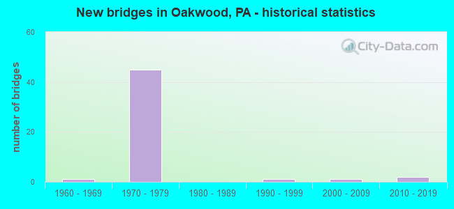
- New bridges - historical statistics
- 11960-1969
- 451970-1979
- 11990-1999
- 12000-2009
- 22010-2019

- Reconstructed bridges - Historical Statistics
- 72000-2009
- 12010-2019


- Bridge Condition - Deck
- 15.0%Very good
- 55.0%Good
- 15.0%Satisfactory
- 15.0%Fair

- Bridge Condition - Superstructure
- 5.0%Excellent
- 5.0%Very good
- 55.0%Good
- 15.0%Satisfactory
- 20.0%Fair

- Bridge Condition - Substructure
- 5.0%Excellent
- 5.0%Very good
- 55.0%Good
- 25.0%Satisfactory
- 10.0%Fair

- Bridge Condition - Channel
- 50.0%Good
- 25.0%Satisfactory
- 25.0%Fair
Find on map >> Show street view
Structure Number: 22194, Location: 376WB O/ RP E,SHENANGO R (Lat: 41.032506, Lng: -80.390214), Route carried "on" structure: Interstate 376, Year Built: 1975, Year Reconstructed: 2013, Status: Open, Structure Length: 19.32m (63.39ft), Average Daily Traffic: 7,518 (year 2021), Truck Traffic: 22%, Average Future Daily Traffic: 8,642 (year 2032), Design Load: HS 20, Features Intersected: 8008 RP.E & SHENANGO RIV
Minimum Vertical Clearance: 30+ m (98+ ft), Kilometerpoint: 11.602, Lanes on structure: 2, Lanes under structure: 1, Base Highway Network: Yes, Owner: State Highway Agency, Approaching Roadway Width: 18.3m (60.0ft), Skew: 12 degrees, Material/Design: Steel continuous, Design/Construction: Girder and Floorbeam System, Number Of Spans In Main Unit: 4, Length of Maximum Span: 55.2m (181.1ft), Curb or Sidewalk Widths: Left: 0.2m (0.7ft), Right: 0.2m (0.7ft), Curb-To-Curb Width: 13.2m (43.3ft), Out-to-Out Width: 14.5m (47.6ft)
Condition: Deck: Good, Superstructure: Good, Substructure: Good, Channel: Good, Operating Rating: 40.8 metric tons, Method Used To Determine Operating Rating: Load Factor (LF), Inventory Rating: 24.5 metric tons, Method Used To Determine Inventory Rating: Load Factor (LF), Structural Evaluation: Equal to present minimum criteria, Deck Geometry: Superior to present desirable criteria, Underclear: Somewhat better than minimum adequacy, Waterway Adequacy: Superior to present desirable criteria, Approach Roadway Alignment: Equal to present desirable criteria, Length Of Structure Improvement: 19.50m (63.98ft), Designated Inspection Frequency: Every 24 months, Critical Feature Inspection Frequency: Every 24 months, Inspection Date: June 2021, Critical Feature Inspection Date: June 2021, Bridge Improvement Cost: $221,000, Roadway Improvement Cost: $650,000, Total Project Cost: $2,980,000, Deck Structure Type: Concrete Cast-file-Place, Wearing Surface/Protective System: Wearing Surface: Latex Concrete
Find on map >> Show street view
Structure Number: 22195, Location: I-376 OVER SHENANGO RIVER (Lat: 41.032569, Lng: -80.390556), Route carried "on" structure: Interstate 376, Year Built: 1975, Year Reconstructed: 2013, Status: Open, Structure Length: 19.32m (63.39ft), Average Daily Traffic: 8,345 (year 2021), Truck Traffic: 20%, Average Future Daily Traffic: 8,556 (year 2032), Design Load: HS 20, Features Intersected: 8008 RP.E & SHENANGO RIV
Minimum Vertical Clearance: 30+ m (98+ ft), Kilometerpoint: 11.611, Lanes on structure: 2, Lanes under structure: 1, Base Highway Network: Yes, Owner: State Highway Agency, Approaching Roadway Width: 12.2m (40.0ft), Skew: 12 degrees, Material/Design: Steel continuous, Design/Construction: Girder and Floorbeam System, Number Of Spans In Main Unit: 4, Length of Maximum Span: 55.2m (181.1ft), Curb or Sidewalk Widths: Left: 0.2m (0.7ft), Right: 0.2m (0.7ft), Curb-To-Curb Width: 11.9m (39.0ft), Out-to-Out Width: 13.2m (43.3ft)
Condition: Deck: Good, Superstructure: Good, Substructure: Good, Channel: Good, Operating Rating: 46.3 metric tons, Method Used To Determine Operating Rating: Load Factor (LF), Inventory Rating: 27.2 metric tons, Method Used To Determine Inventory Rating: Load Factor (LF), Structural Evaluation: Equal to present minimum criteria, Deck Geometry: Equal to present minimum criteria, Underclear: Superior to present desirable criteria, Waterway Adequacy: Superior to present desirable criteria, Approach Roadway Alignment: Equal to present desirable criteria, Length Of Structure Improvement: 19.40m (63.65ft), Designated Inspection Frequency: Every 24 months, Critical Feature Inspection Frequency: Every 24 months, Inspection Date: June 2021, Critical Feature Inspection Date: June 2021, Bridge Improvement Cost: $199,000, Roadway Improvement Cost: $587,000, Total Project Cost: $2,689,000, Deck Structure Type: Concrete Cast-file-Place, Wearing Surface/Protective System: Wearing Surface: Latex Concrete
Find on map >> Show street view
Structure Number: 22197, Location: 1/2 MI. NORTH OF SR 0422 (Lat: 41.033794, Lng: -80.390308), Route carried "on" structure: Interstate 376, Year Built: 1975, Status: Open, Structure Length: 5.85m (19.19ft), Average Daily Traffic: 7,518 (year 2021), Truck Traffic: 22%, Average Future Daily Traffic: 8,642 (year 2032), Design Load: HS 20, Features Intersected: SR 4004 PULASKI RD
Minimum Vertical Clearance: 30+ m (98+ ft), Kilometerpoint: 11.602, Lanes on structure: 2, Lanes under structure: 2, Base Highway Network: Yes, Owner: State Highway Agency, Approaching Roadway Width: 12.2m (40.0ft), Skew: 11 degrees, Material/Design: Prestressed concrete, Design/Construction: Stringer/Multi-beam, Number Of Spans In Main Unit: 3, Length of Maximum Span: 27.4m (89.9ft), Curb or Sidewalk Widths: Left: 0.2m (0.7ft), Right: 0.2m (0.7ft), Curb-To-Curb Width: 12.0m (39.4ft), Out-to-Out Width: 13.2m (43.3ft)
Condition: Deck: Good, Superstructure: Good, Substructure: Good, Operating Rating: 65.3 metric tons, Method Used To Determine Operating Rating: Load Factor (LF), Inventory Rating: 25.4 metric tons, Method Used To Determine Inventory Rating: Load Factor (LF), Structural Evaluation: Equal to present minimum criteria, Deck Geometry: Equal to present minimum criteria, Underclear: Superior to present desirable criteria, Approach Roadway Alignment: Equal to present desirable criteria, Length Of Structure Improvement: 5.90m (19.36ft), Designated Inspection Frequency: Every 24 months, Inspection Date: June 2021, Bridge Improvement Cost: $48,000, Roadway Improvement Cost: $142,000, Total Project Cost: $650,000, Deck Structure Type: Concrete Cast-file-Place, Wearing Surface/Protective System: Wearing Surface: Latex Concrete
Find on map >> Show street view
Structure Number: 22198, Location: 1/2 MI. NORTH OF SR 0422 (Lat: 41.033822, Lng: -80.390656), Route carried "on" structure: Interstate 376, Year Built: 1975, Status: Open, Structure Length: 5.85m (19.19ft), Average Daily Traffic: 8,345 (year 2021), Truck Traffic: 20%, Average Future Daily Traffic: 8,556 (year 2032), Design Load: HS 20, Features Intersected: SR 4004 PULASKI RD
Minimum Vertical Clearance: 30+ m (98+ ft), Kilometerpoint: 11.611, Lanes on structure: 2, Lanes under structure: 2, Base Highway Network: Yes, Owner: State Highway Agency, Approaching Roadway Width: 12.2m (40.0ft), Skew: 11 degrees, Material/Design: Prestressed concrete, Design/Construction: Stringer/Multi-beam, Number Of Spans In Main Unit: 3, Length of Maximum Span: 27.4m (89.9ft), Curb or Sidewalk Widths: Left: 0.2m (0.7ft), Right: 0.2m (0.7ft), Curb-To-Curb Width: 12.0m (39.4ft), Out-to-Out Width: 13.2m (43.3ft)
Condition: Deck: Good, Superstructure: Good, Substructure: Good, Operating Rating: 64.4 metric tons, Method Used To Determine Operating Rating: Load Factor (LF), Inventory Rating: 26.3 metric tons, Method Used To Determine Inventory Rating: Load Factor (LF), Structural Evaluation: Equal to present minimum criteria, Deck Geometry: Equal to present minimum criteria, Underclear: Superior to present desirable criteria, Approach Roadway Alignment: Equal to present desirable criteria, Length Of Structure Improvement: 5.90m (19.36ft), Designated Inspection Frequency: Every 24 months, Inspection Date: June 2021, Bridge Improvement Cost: $48,000, Roadway Improvement Cost: $142,000, Total Project Cost: $650,000, Deck Structure Type: Concrete Cast-file-Place, Wearing Surface/Protective System: Wearing Surface: Latex Concrete
Find on map >> Show street view
Structure Number: 22203, Location: 1/2 MI. SOUTH OF SR 8002 (Lat: 41.062153, Lng: -80.383319), Route carried "on" structure: Interstate 376, Year Built: 1971, Status: Open, Structure Length: 5.88m (19.29ft), Average Daily Traffic: 7,518 (year 2021), Truck Traffic: 22%, Average Future Daily Traffic: 8,642 (year 2032), Design Load: HS 20, Features Intersected: OLD PULASKI RD
Minimum Vertical Clearance: 30+ m (98+ ft), Kilometerpoint: 8.401, Lanes on structure: 2, Lanes under structure: 2, Base Highway Network: Yes, Owner: State Highway Agency, Approaching Roadway Width: 11.9m (39.0ft), Skew: 15 degrees, Material/Design: Steel, Design/Construction: Stringer/Multi-beam, Number Of Spans In Main Unit: 1, Number Of Approach Spans: 2, Length of Maximum Span: 27.7m (90.9ft), Curb or Sidewalk Widths: Left: 0.2m (0.7ft), Right: 0.2m (0.7ft), Curb-To-Curb Width: 12.6m (41.3ft), Out-to-Out Width: 13.2m (43.3ft)
Condition: Deck: Fair, Superstructure: Fair, Substructure: Fair, Operating Rating: 57.2 metric tons, Method Used To Determine Operating Rating: Load Factor (LF), Inventory Rating: 33.6 metric tons, Method Used To Determine Inventory Rating: Load Factor (LF), Structural Evaluation: Somewhat better than minimum adequacy, Deck Geometry: Better than present minimum criteria, Underclear: Equal to present minimum criteria, Approach Roadway Alignment: Equal to present desirable criteria, Length Of Structure Improvement: 5.90m (19.36ft), Designated Inspection Frequency: Every 24 months, Inspection Date: June 2021, Bridge Improvement Cost: $14,000, Roadway Improvement Cost: $41,000, Total Project Cost: $188,000, Deck Structure Type: Concrete Cast-file-Place, Wearing Surface/Protective System: Wearing Surface: Latex Concrete
Find on map >> Show street view
Structure Number: 22204, Location: 1/2 MI. SOUTH OF SR 8002 (Lat: 41.062544, Lng: -80.383383), Route carried "on" structure: Interstate 376, Year Built: 1970, Status: Open, Structure Length: 5.88m (19.29ft), Average Daily Traffic: 8,345 (year 2021), Truck Traffic: 20%, Average Future Daily Traffic: 8,556 (year 2032), Design Load: HS 20, Features Intersected: OLD PULASKI RD
Minimum Vertical Clearance: 30+ m (98+ ft), Kilometerpoint: 8.391, Lanes on structure: 2, Lanes under structure: 2, Base Highway Network: Yes, Owner: State Highway Agency, Approaching Roadway Width: 11.9m (39.0ft), Skew: 15 degrees, Material/Design: Steel, Design/Construction: Stringer/Multi-beam, Number Of Spans In Main Unit: 1, Number Of Approach Spans: 2, Length of Maximum Span: 27.7m (90.9ft), Curb or Sidewalk Widths: Left: 0.2m (0.7ft), Right: 0.2m (0.7ft), Curb-To-Curb Width: 12.6m (41.3ft), Out-to-Out Width: 13.2m (43.3ft)
Condition: Deck: Fair, Superstructure: Fair, Substructure: Fair, Operating Rating: 60.8 metric tons, Method Used To Determine Operating Rating: Load Factor (LF), Inventory Rating: 36.3 metric tons, Method Used To Determine Inventory Rating: Load Factor (LF), Structural Evaluation: Somewhat better than minimum adequacy, Deck Geometry: Better than present minimum criteria, Underclear: Equal to present minimum criteria, Approach Roadway Alignment: Equal to present desirable criteria, Length Of Structure Improvement: 5.90m (19.36ft), Designated Inspection Frequency: Every 24 months, Inspection Date: June 2021, Bridge Improvement Cost: $14,000, Roadway Improvement Cost: $41,000, Total Project Cost: $188,000, Deck Structure Type: Concrete Cast-file-Place, Wearing Surface/Protective System: Wearing Surface: Latex Concrete
Find on map >> Show street view
Structure Number: 22283, Location: SR 0224 STATE ST (Lat: 41.010933, Lng: -80.391400), Route carried "on" structure: US 224, Year Built: 1973, Status: Open, Structure Length: 8.81m (28.90ft), Average Daily Traffic: 11,526 (year 2022), Truck Traffic: 4%, Average Future Daily Traffic: 11,998 (year 2032), Design Load: HS 20, Features Intersected: SR 0376, RAMP K, Facility Carried by Structure: STATE STREET
Minimum Vertical Clearance: 30+ m (98+ ft), Kilometerpoint: 12.384, Lanes on structure: 5, Lanes under structure: 15, Base Highway Network: Yes, Owner: State Highway Agency, Approaching Roadway Width: 31.4m (103.0ft), Skew: 21 degrees, Material/Design: Steel, Design/Construction: Stringer/Multi-beam, Number Of Spans In Main Unit: 2, Number Of Approach Spans: 2, Length of Maximum Span: 37.5m (123.0ft), Curb or Sidewalk Widths: Left: 0.2m (0.7ft), Right: 0.2m (0.7ft), Curb-To-Curb Width: 31.4m (103.0ft), Out-to-Out Width: 32.6m (107.0ft)
Condition: Deck: Good, Superstructure: Satisfactory, Substructure: Good, Operating Rating: 61.7 metric tons, Method Used To Determine Operating Rating: Load Factor (LF), Inventory Rating: 37.2 metric tons, Method Used To Determine Inventory Rating: Load Factor (LF), Structural Evaluation: Equal to present minimum criteria, Deck Geometry: Superior to present desirable criteria, Underclear: High priority of corrective action, Approach Roadway Alignment: Equal to present desirable criteria, Length Of Structure Improvement: 8.80m (28.87ft), Designated Inspection Frequency: Every 24 months, Inspection Date: September 2020, Bridge Improvement Cost: $166,000, Roadway Improvement Cost: $489,000, Total Project Cost: $2,242,000, Deck Structure Type: Concrete Cast-file-Place, Wearing Surface/Protective System: Wearing Surface: Latex Concrete
Find on map >> Show street view
Structure Number: 22306, Location: 150'EAST OF SR 4007 (Lat: 41.037208, Lng: -80.409617), Route carried "on" structure: US 422, Year Built: 1975, Status: Open, Structure Length: 0.94m (3.08ft), Average Daily Traffic: 6,351 (year 2021), Truck Traffic: 9%, Average Future Daily Traffic: 5,469 (year 2032), Design Load: HS 20, Features Intersected: SANKEY RUN
Minimum Vertical Clearance: 30+ m (98+ ft), Kilometerpoint: 10.778, Lanes on structure: 5, Base Highway Network: Yes, Owner: State Highway Agency, Approaching Roadway Width: 29.3m (96.1ft), Skew: 30 degrees, Material/Design: Concrete, Design/Construction: Slab, Number Of Spans In Main Unit: 1, Length of Maximum Span: 8.5m (27.9ft), Curb or Sidewalk Widths: Left: 0.2m (0.7ft), Right: 0.2m (0.7ft), Curb-To-Curb Width: 29.1m (95.5ft), Out-to-Out Width: 30.5m (100.1ft)
Condition: Deck: Good, Superstructure: Good, Substructure: Satisfactory, Channel: Fair, Operating Rating: 69.9 metric tons, Method Used To Determine Operating Rating: Load Factor (LF), Inventory Rating: 41.7 metric tons, Method Used To Determine Inventory Rating: Load Factor (LF), Structural Evaluation: Equal to present minimum criteria, Deck Geometry: Superior to present desirable criteria, Waterway Adequacy: Equal to present minimum criteria, Approach Roadway Alignment: Equal to present desirable criteria, Length Of Structure Improvement: 0.90m (2.95ft), Designated Inspection Frequency: Every 24 months, Inspection Date: September 2021, Deck Structure Type: Concrete Cast-file-Place, Wearing Surface/Protective System: Wearing Surface: Monolithic Concrete
Find on map >> Show street view
Structure Number: 22309, Location: I-376 EB OVER BUS. 422 (Lat: 41.029094, Lng: -80.390286), Route carried "on" structure: Interstate 376, Year Built: 1975, Year Reconstructed: 2013, Status: Open, Structure Length: 8.90m (29.20ft), Average Daily Traffic: 9,380 (year 2021), Truck Traffic: 20%, Average Future Daily Traffic: 9,593 (year 2032), Design Load: HS 20, Features Intersected: US 422 EB WB
Minimum Vertical Clearance: 6.10m (20.01ft), Kilometerpoint: 12.534, Lanes on structure: 3, Lanes under structure: 12, Base Highway Network: Yes, Owner: State Highway Agency, Approaching Roadway Width: 16.5m (54.1ft), Skew: 3 degrees, Material/Design: Steel, Design/Construction: Stringer/Multi-beam, Number Of Spans In Main Unit: 1, Number Of Approach Spans: 2, Length of Maximum Span: 50.0m (164.0ft), Curb or Sidewalk Widths: Left: 0.2m (0.7ft), Right: 0.2m (0.7ft), Curb-To-Curb Width: 16.2m (53.1ft), Out-to-Out Width: 17.4m (57.1ft)
Condition: Deck: Good, Superstructure: Good, Substructure: Good, Operating Rating: 81.6 metric tons, Method Used To Determine Operating Rating: Load Factor (LF), Inventory Rating: 49.0 metric tons, Method Used To Determine Inventory Rating: Load Factor (LF), Structural Evaluation: Better than present minimum criteria, Deck Geometry: Equal to present minimum criteria, Underclear: Equal to present minimum criteria, Approach Roadway Alignment: Equal to present desirable criteria, Length Of Structure Improvement: 8.90m (29.20ft), Designated Inspection Frequency: Every 24 months, Inspection Date: June 2021, Bridge Improvement Cost: $42,000, Roadway Improvement Cost: $123,000, Total Project Cost: $565,000, Deck Structure Type: Concrete Cast-file-Place, Wearing Surface/Protective System: Wearing Surface: Latex Concrete
Find on map >> Show street view
Structure Number: 2231, Location: I-376 WB OVER BUS. 422 (Lat: 41.029022, Lng: -80.389931), Route carried "on" structure: Interstate 376, Year Built: 1975, Year Reconstructed: 2013, Status: Open, Structure Length: 8.90m (29.20ft), Average Daily Traffic: 9,618 (year 2021), Truck Traffic: 17%, Average Future Daily Traffic: 9,004 (year 2032), Design Load: HS 20, Features Intersected: US 422 EB WB
Minimum Vertical Clearance: 6.10m (20.01ft), Kilometerpoint: 12.542, Lanes on structure: 3, Lanes under structure: 24, Base Highway Network: Yes, Owner: State Highway Agency, Approaching Roadway Width: 16.5m (54.1ft), Skew: 3 degrees, Material/Design: Steel, Design/Construction: Stringer/Multi-beam, Number Of Spans In Main Unit: 1, Number Of Approach Spans: 2, Length of Maximum Span: 50.0m (164.0ft), Curb or Sidewalk Widths: Left: 0.2m (0.7ft), Right: 0.2m (0.7ft), Curb-To-Curb Width: 16.2m (53.1ft), Out-to-Out Width: 17.4m (57.1ft)
Condition: Deck: Good, Superstructure: Good, Substructure: Good, Operating Rating: 81.6 metric tons, Method Used To Determine Operating Rating: Load Factor (LF), Inventory Rating: 49.0 metric tons, Method Used To Determine Inventory Rating: Load Factor (LF), Structural Evaluation: Better than present minimum criteria, Deck Geometry: Equal to present minimum criteria, Underclear: Equal to present minimum criteria, Approach Roadway Alignment: Equal to present desirable criteria, Length Of Structure Improvement: 8.90m (29.20ft), Designated Inspection Frequency: Every 24 months, Inspection Date: June 2021, Bridge Improvement Cost: $30,000, Roadway Improvement Cost: $104,000, Total Project Cost: $407,000, Deck Structure Type: Concrete Cast-file-Place, Wearing Surface/Protective System: Wearing Surface: Latex Concrete
Find on map >> Show street view
Structure Number: 22317, Location: SR 0422 EB OVER I-376 (Lat: 40.991894, Lng: -80.388961), Route carried "on" structure: US 422, Year Built: 1972, Status: Open, Structure Length: 8.81m (28.90ft), Average Daily Traffic: 7,190 (year 2020), Truck Traffic: 14%, Average Future Daily Traffic: 9,539 (year 2032), Design Load: HS 20, Features Intersected: 376 TOLL & RMP N EB
Minimum Vertical Clearance: 30+ m (98+ ft), Kilometerpoint: 12.976, Lanes on structure: 2, Lanes under structure: 3, Base Highway Network: Yes, Owner: State Highway Agency, Approaching Roadway Width: 12.8m (42.0ft), Skew: 12 degrees, Material/Design: Prestressed concrete, Design/Construction: Stringer/Multi-beam, Number Of Spans In Main Unit: 4, Length of Maximum Span: 29.3m (96.1ft), Curb or Sidewalk Widths: Left: 0.2m (0.7ft), Right: 0.2m (0.7ft), Curb-To-Curb Width: 11.9m (39.0ft), Out-to-Out Width: 13.2m (43.3ft)
Condition: Deck: Good, Superstructure: Satisfactory, Substructure: Satisfactory, Operating Rating: 78.9 metric tons, Method Used To Determine Operating Rating: Load Factor (LF), Inventory Rating: 29.0 metric tons, Method Used To Determine Inventory Rating: Load Factor (LF), Structural Evaluation: Equal to present minimum criteria, Deck Geometry: Better than present minimum criteria, Underclear: Meets minimum limits, Approach Roadway Alignment: Equal to present desirable criteria, Length Of Structure Improvement: 8.80m (28.87ft), Designated Inspection Frequency: Every 24 months, Inspection Date: September 2021, Bridge Improvement Cost: $90,000, Roadway Improvement Cost: $264,000, Total Project Cost: $1,209,000, Deck Structure Type: Concrete Cast-file-Place, Wearing Surface/Protective System: Wearing Surface: Monolithic Concrete
Find on map >> Show street view
Structure Number: 22319, Location: SR 0422 WB OVER I-376 (Lat: 40.992350, Lng: -80.389056), Route carried "on" structure: US 422, Year Built: 1972, Status: Open, Structure Length: 8.32m (27.30ft), Average Daily Traffic: 7,439 (year 2020), Truck Traffic: 15%, Average Future Daily Traffic: 9,926 (year 2032), Design Load: HS 20, Features Intersected: I-376 TOLL & RP N EB
Minimum Vertical Clearance: 30+ m (98+ ft), Kilometerpoint: 13.700, Lanes on structure: 2, Lanes under structure: 3, Base Highway Network: Yes, Owner: State Highway Agency, Approaching Roadway Width: 12.8m (42.0ft), Skew: 12 degrees, Material/Design: Prestressed concrete, Design/Construction: Stringer/Multi-beam, Number Of Spans In Main Unit: 4, Length of Maximum Span: 29.3m (96.1ft), Curb or Sidewalk Widths: Left: 0.2m (0.7ft), Right: 0.2m (0.7ft), Curb-To-Curb Width: 11.9m (39.0ft), Out-to-Out Width: 13.2m (43.3ft)
Condition: Deck: Good, Superstructure: Good, Substructure: Satisfactory, Operating Rating: 71.7 metric tons, Method Used To Determine Operating Rating: Load Factor (LF), Inventory Rating: 23.6 metric tons, Method Used To Determine Inventory Rating: Load Factor (LF), Structural Evaluation: Somewhat better than minimum adequacy, Deck Geometry: Better than present minimum criteria, Underclear: Meets minimum limits, Approach Roadway Alignment: Equal to present desirable criteria, Length Of Structure Improvement: 8.30m (27.23ft), Designated Inspection Frequency: Every 24 months, Inspection Date: September 2021, Bridge Improvement Cost: $78,000, Roadway Improvement Cost: $229,000, Total Project Cost: $1,051,000, Deck Structure Type: Concrete Cast-file-Place, Wearing Surface/Protective System: Wearing Surface: Monolithic Concrete
Find on map >> Show street view
Structure Number: 2245, Location: COVERT RD. OVER 376 (Lat: 40.996219, Lng: -80.392092), Route carried "on" structure: State highway , Year Built: 1972, Year Reconstructed: 2006, Status: Open, Structure Length: 8.47m (27.79ft), Average Daily Traffic: 2,288 (year 2021), Truck Traffic: 7%, Average Future Daily Traffic: 2,225 (year 2032), Design Load: HS 20, Features Intersected: SR 0376 EB WB, Facility Carried by Structure: COVERT RD
Minimum Vertical Clearance: 30+ m (98+ ft), Kilometerpoint: 0.000, Lanes on structure: 2, Lanes under structure: 5, Owner: State Highway Agency, Approaching Roadway Width: 7.3m (24.0ft), Skew: 1 degrees, Material/Design: Prestressed concrete, Design/Construction: Stringer/Multi-beam, Number Of Spans In Main Unit: 4, Length of Maximum Span: 31.7m (104.0ft), Curb or Sidewalk Widths: Left: 0.2m (0.7ft), Right: 0.2m (0.7ft), Curb-To-Curb Width: 13.4m (44.0ft), Out-to-Out Width: 14.6m (47.9ft)
Condition: Deck: Fair, Superstructure: Good, Substructure: Satisfactory, Operating Rating: 72.6 metric tons, Method Used To Determine Operating Rating: Load Factor (LF), Inventory Rating: 23.6 metric tons, Method Used To Determine Inventory Rating: Load Factor (LF), Structural Evaluation: Equal to present minimum criteria, Deck Geometry: Better than present minimum criteria, Underclear: Superior to present desirable criteria, Approach Roadway Alignment: Equal to present desirable criteria, Length Of Structure Improvement: 8.50m (27.89ft), Designated Inspection Frequency: Every 24 months, Inspection Date: July 2020, Bridge Improvement Cost: $76,000, Roadway Improvement Cost: $224,000, Total Project Cost: $1,027,000, Deck Structure Type: Concrete Cast-file-Place, Wearing Surface/Protective System: Wearing Surface: Epoxy Overlay
Find on map >> Show street view
Structure Number: 22451, Location: 1/2 MI.N.E.OF TR 60 (Lat: 40.996139, Lng: -80.392036), Route carried "on" structure: State highway , Year Built: 1973, Year Reconstructed: 2007, Status: Open, Structure Length: 8.32m (27.30ft), Average Daily Traffic: 2,288 (year 2021), Truck Traffic: 7%, Average Future Daily Traffic: 2,225 (year 2032), Design Load: HS 20, Features Intersected: LR 1023,PA 60 N.B., Facility Carried by Structure: COVERT RD
Minimum Vertical Clearance: 30+ m (98+ ft), Kilometerpoint: 0.085, Lanes on structure: 2, Lanes under structure: 2, Owner: State Highway Agency, Approaching Roadway Width: 10.4m (34.1ft), Skew: 3 degrees, Material/Design: Steel continuous, Design/Construction: Stringer/Multi-beam, Number Of Spans In Main Unit: 3, Length of Maximum Span: 34.4m (112.9ft), Curb or Sidewalk Widths: Left: 0.2m (0.7ft), Right: 0.2m (0.7ft), Curb-To-Curb Width: 13.4m (44.0ft), Out-to-Out Width: 14.6m (47.9ft)
Condition: Deck: Satisfactory, Superstructure: Satisfactory, Substructure: Satisfactory, Operating Rating: 50.8 metric tons, Method Used To Determine Operating Rating: Load Factor (LF), Inventory Rating: 30.8 metric tons, Method Used To Determine Inventory Rating: Load Factor (LF), Structural Evaluation: Equal to present minimum criteria, Deck Geometry: Better than present minimum criteria, Underclear: Superior to present desirable criteria, Approach Roadway Alignment: Equal to present desirable criteria, Length Of Structure Improvement: 9.30m (30.51ft), Designated Inspection Frequency: Every 24 months, Inspection Date: July 2020, Deck Structure Type: Concrete Cast-file-Place, Wearing Surface/Protective System: Wearing Surface: Monolithic Concrete
Find on map >> Show street view
Structure Number: 22467, Location: 1/4 MI. N.E. OF SR 0422 (Lat: 41.036833, Lng: -80.402967), Route carried "on" structure: State highway , Year Built: 1966, Year Reconstructed: 2017, Status: Open, Structure Length: 6.00m (19.69ft), Average Daily Traffic: 5,048 (year 2020), Truck Traffic: 2%, Average Future Daily Traffic: 8,052 (year 2032), Design Load: HL 93, Features Intersected: SHENANGO RIVER, Facility Carried by Structure: HARBOR EDINBURG RD
Minimum Vertical Clearance: 30+ m (98+ ft), Kilometerpoint: 3.330, Lanes on structure: 2, Owner: State Highway Agency, Approaching Roadway Width: 10.1m (33.1ft), Material/Design: Prestressed concrete, Design/Construction: Box Beam or Girders - Multiple, Number Of Spans In Main Unit: 2, Length of Maximum Span: 29.9m (98.1ft), Curb or Sidewalk Widths: Left: 0.5m (1.6ft), Right: 0.5m (1.6ft), Curb-To-Curb Width: 9.1m (29.9ft), Out-to-Out Width: 10.8m (35.4ft)
Condition: Deck: Very good, Superstructure: Fair, Substructure: Good, Channel: Satisfactory, Operating Rating: 73.5 metric tons, Method Used To Determine Operating Rating: Load and Resistance Factor (LRFR), Inventory Rating: 26.3 metric tons, Method Used To Determine Inventory Rating: Load and Resistance Factor (LRFR), Structural Evaluation: Somewhat better than minimum adequacy, Deck Geometry: High priority of corrective action, Waterway Adequacy: Better than present minimum criteria, Approach Roadway Alignment: Equal to present desirable criteria, Length Of Structure Improvement: 6.00m (19.69ft), Designated Inspection Frequency: Every 24 months, Inspection Date: August 2020, Bridge Improvement Cost: $97,000, Roadway Improvement Cost: $286,000, Total Project Cost: $1,312,000, Deck Structure Type: Concrete Cast-file-Place, Wearing Surface/Protective System: Wearing Surface: Bituminous, Deck Protection: Epoxy Coated Reinforcing
Find on map >> Show street view
Structure Number: 22481, Location: MITCHELL RD. OVER SR376 (Lat: 41.067256, Lng: -80.379972), Route carried "on" structure: State highway , Year Built: 1970, Year Reconstructed: 2008, Status: Open, Structure Length: 9.30m (30.51ft), Average Daily Traffic: 8,952 (year 2022), Truck Traffic: 4%, Average Future Daily Traffic: 10,258 (year 2032), Design Load: HS 20, Features Intersected: SR 0376, Facility Carried by Structure: MITCHELL ROAD
Minimum Vertical Clearance: 30+ m (98+ ft), Kilometerpoint: 0.000, Lanes on structure: 2, Lanes under structure: 10, Owner: State Highway Agency, Approaching Roadway Width: 18.3m (60.0ft), Skew: 31 degrees, Material/Design: Prestressed concrete, Design/Construction: Stringer/Multi-beam, Number Of Spans In Main Unit: 4, Length of Maximum Span: 31.7m (104.0ft), Curb or Sidewalk Widths: Left: 0.2m (0.7ft), Right: 0.2m (0.7ft), Curb-To-Curb Width: 18.3m (60.0ft), Out-to-Out Width: 19.5m (64.0ft)
Condition: Deck: Satisfactory, Superstructure: Fair, Substructure: Good, Operating Rating: 64.4 metric tons, Method Used To Determine Operating Rating: Load Factor (LF), Inventory Rating: 22.7 metric tons, Method Used To Determine Inventory Rating: Load Factor (LF), Structural Evaluation: Somewhat better than minimum adequacy, Deck Geometry: Superior to present desirable criteria, Underclear: High priority of corrective action, Approach Roadway Alignment: Equal to present minimum criteria, Length Of Structure Improvement: 9.30m (30.51ft), Designated Inspection Frequency: Every 24 months, Inspection Date: August 2020, Bridge Improvement Cost: $211,000, Roadway Improvement Cost: $621,000, Total Project Cost: $2,847,000, Deck Structure Type: Concrete Cast-file-Place, Wearing Surface/Protective System: Wearing Surface: Latex Concrete
Find on map >> Show street view
Structure Number: 22592, Location: 1000' EAST OF SR 0060 (Lat: 41.025000, Lng: -80.386667), Route carried "on" structure: Ramp State highway , Year Built: 1975, Status: Open, Structure Length: 7.86m (25.79ft), Average Daily Traffic: 1,899 (year 2021), Truck Traffic: 7%, Average Future Daily Traffic: 2,864 (year 2032), Design Load: HS 20, Features Intersected: SR 4002, Facility Carried by Structure: SR 8008 RAMP E
Minimum Vertical Clearance: 30+ m (98+ ft), Kilometerpoint: 0.000, Lanes on structure: 1, Lanes under structure: 10, Base Highway Network: Yes, Owner: State Highway Agency, Approaching Roadway Width: 10.7m (35.1ft), Skew: 2 degrees, Material/Design: Steel, Design/Construction: Stringer/Multi-beam, Number Of Spans In Main Unit: 1, Number Of Approach Spans: 2, Length of Maximum Span: 49.1m (161.1ft), Curb or Sidewalk Widths: Left: 0.2m (0.7ft), Right: 0.2m (0.7ft), Curb-To-Curb Width: 9.2m (30.2ft), Out-to-Out Width: 10.4m (34.1ft)
Condition: Deck: Good, Superstructure: Good, Substructure: Good, Operating Rating: 76.2 metric tons, Method Used To Determine Operating Rating: Load Factor (LF), Inventory Rating: 45.4 metric tons, Method Used To Determine Inventory Rating: Load Factor (LF), Structural Evaluation: Better than present minimum criteria, Deck Geometry: Superior to present desirable criteria, Underclear: Equal to present minimum criteria, Approach Roadway Alignment: Equal to present desirable criteria, Length Of Structure Improvement: 7.90m (25.92ft), Designated Inspection Frequency: Every 24 months, Inspection Date: September 2021, Deck Structure Type: Concrete Cast-file-Place, Wearing Surface/Protective System: Wearing Surface: Latex Concrete
Find on map >> Show street view
Structure Number: 405, Location: 214001 1 BLK S OF OAKWOOD (Lat: 41.004353, Lng: -80.373008), Route carried "on" structure: City street , Year Built: 1998, Status: Open, Structure Length: 0.98m (3.22ft), Average Daily Traffic: 1,000 (year 2005), Truck Traffic: 5%, Average Future Daily Traffic: 1,400 (year 2025), Design Load: HS 25 or greater, Features Intersected: SHENANGO RIVER TRIBUTARY, Facility Carried by Structure: GRANDVIEW AVENUE
Minimum Vertical Clearance: 30+ m (98+ ft), Kilometerpoint: 0.000, Lanes on structure: 2, Owner: Town or Township Highway Agency, Approaching Roadway Width: 8.5m (27.9ft), Material/Design: Prestressed concrete, Design/Construction: Box Beam or Girders - Single/Spread, Number Of Spans In Main Unit: 1, Length of Maximum Span: 9.4m (30.8ft), Curb or Sidewalk Widths: Left: 0.2m (0.7ft), Right: 0.2m (0.7ft), Curb-To-Curb Width: 8.6m (28.2ft), Out-to-Out Width: 9.7m (31.8ft)
Condition: Deck: Satisfactory, Superstructure: Good, Substructure: Good, Channel: Fair, Operating Rating: 75.3 metric tons, Method Used To Determine Operating Rating: Load Factor (LF), Inventory Rating: 44.5 metric tons, Method Used To Determine Inventory Rating: Load Factor (LF), Structural Evaluation: Better than present minimum criteria, Deck Geometry: Somewhat better than minimum adequacy, Waterway Adequacy: Equal to present desirable criteria, Approach Roadway Alignment: Equal to present minimum criteria, Length Of Structure Improvement: 1.00m (3.28ft), Designated Inspection Frequency: Every 24 months, Inspection Date: June 2021, Deck Structure Type: Concrete Cast-file-Place, Wearing Surface/Protective System: Wearing Surface: Monolithic Concrete, Deck Protection: Epoxy Coated Reinforcing
Find on map >> Show street view
Structure Number: 41479, Location: 214002 1 BLK S OF OAKWOOD (Lat: 41.004042, Lng: -80.370372), Route carried "on" structure: City street , Year Built: 2001, Status: Open, Structure Length: 0.61m (2.00ft), Average Daily Traffic: 1,000 (year 2005), Truck Traffic: 1%, Average Future Daily Traffic: 1,100 (year 2025), Design Load: HS 25 or greater, Features Intersected: SHENANGO RIVER TRIB, Facility Carried by Structure: MILLER AVE
Minimum Vertical Clearance: 30+ m (98+ ft), Kilometerpoint: 0.000, Lanes on structure: 2, Owner: Town or Township Highway Agency, Approaching Roadway Width: 9.8m (32.2ft), Skew: 1 degrees, Material/Design: Concrete, Design/Construction: Culvert, Number Of Spans In Main Unit: 1, Length of Maximum Span: 6.1m (20.0ft)
Condition: Channel: Satisfactory, Culverts: Good, Operating Rating: 89.8 metric tons, Method Used To Determine Operating Rating: Load Factor (LF), Inventory Rating: 77.1 metric tons, Method Used To Determine Inventory Rating: Load Factor (LF), Structural Evaluation: Better than present minimum criteria, Waterway Adequacy: Superior to present desirable criteria, Approach Roadway Alignment: Equal to present desirable criteria, Length Of Structure Improvement: 0.60m (1.97ft), Designated Inspection Frequency: Every 24 months, Inspection Date: June 2021, Bridge Improvement Cost: $22,000, Roadway Improvement Cost: $64,000, Total Project Cost: $294,000
Find on map >> Show street view
Structure Number: 46586, Location: 200' SE OF SR 422 (Lat: 41.036853, Lng: -80.410439), Route carried "on" structure: State highway , Year Built: 2011, Status: Open, Structure Length: 1.58m (5.18ft), Average Daily Traffic: 1,281 (year 2021), Truck Traffic: 4%, Average Future Daily Traffic: 50 (year 2017), Design Load: HL 93, Features Intersected: SANKEY RUN, Facility Carried by Structure: AIRPORT HILL ROAD
Minimum Vertical Clearance: 30+ m (98+ ft), Kilometerpoint: 1.508, Lanes on structure: 2, Owner: State Highway Agency, Approaching Roadway Width: 9.8m (32.2ft), Skew: 1 degrees, Material/Design: Steel, Design/Construction: Stringer/Multi-beam, Number Of Spans In Main Unit: 1, Length of Maximum Span: 14.9m (48.9ft), Curb or Sidewalk Widths: Left: 0.2m (0.7ft), Right: 0.2m (0.7ft), Curb-To-Curb Width: 8.5m (27.9ft), Out-to-Out Width: 9.5m (31.2ft)
Condition: Deck: Very good, Superstructure: Excellent, Substructure: Excellent, Channel: Good, Operating Rating: 43.1 metric tons, Method Used To Determine Operating Rating: Assigned ratings based on Load and Resistance Factor Design (LRFD) reported by rating factor (RF) using HL93 loadings, Inventory Rating: 33.0 metric tons, Method Used To Determine Inventory Rating: Assigned ratings based on Load and Resistance Factor Design (LRFD) reported by rating factor (RF) using HL93 loadings, Structural Evaluation: Superior to present desirable criteria, Deck Geometry: Somewhat better than minimum adequacy, Waterway Adequacy: Better than present minimum criteria, Approach Roadway Alignment: Better than present minimum criteria, Designated Inspection Frequency: Every 48 months, Inspection Date: August 2018, Deck Structure Type: Concrete Cast-file-Place, Wearing Surface/Protective System: Wearing Surface: Monolithic Concrete, Deck Protection: Epoxy Coated Reinforcing
Find on map >> Show street view
Structure Number: 47302, Location: 1/4 MI.SOUTH TWP.551 (Lat: 41.051519, Lng: -80.382356), Route carried "on" structure: State highway , Year Built: 2011, Status: Open, Structure Length: 0.82m (2.69ft), Average Daily Traffic: 518 (year 2020), Truck Traffic: 1%, Average Future Daily Traffic: 978 (year 2032), Design Load: HL 93, Features Intersected: CAMP RUN, Facility Carried by Structure: OLD PULASKI
Minimum Vertical Clearance: 30+ m (98+ ft), Kilometerpoint: 2.099, Lanes on structure: 2, Owner: State Highway Agency, Approaching Roadway Width: 9.8m (32.2ft), Material/Design: Prestressed concrete, Design/Construction: Box Beam or Girders - Single/Spread, Number Of Spans In Main Unit: 1, Length of Maximum Span: 8.2m (26.9ft), Curb or Sidewalk Widths: Left: 0.3m (1.0ft), Right: 0.3m (1.0ft), Curb-To-Curb Width: 7.3m (24.0ft), Out-to-Out Width: 8.4m (27.6ft)
Condition: Deck: Very good, Superstructure: Very good, Substructure: Very good, Channel: Good, Operating Rating: 59.6 metric tons, Method Used To Determine Operating Rating: Assigned ratings based on Load and Resistance Factor Design (LRFD) reported by rating factor (RF) using HL93 loadings, Inventory Rating: 37.6 metric tons, Method Used To Determine Inventory Rating: Assigned ratings based on Load and Resistance Factor Design (LRFD) reported by rating factor (RF) using HL93 loadings, Structural Evaluation: Equal to present desirable criteria, Deck Geometry: Meets minimum limits, Waterway Adequacy: Better than present minimum criteria, Approach Roadway Alignment: Equal to present desirable criteria, Designated Inspection Frequency: Every 48 months, Inspection Date: August 2018, Deck Structure Type: Concrete Cast-file-Place, Wearing Surface/Protective System: Wearing Surface: Monolithic Concrete, Deck Protection: Epoxy Coated Reinforcing
Find on map >> Show street view
Structure Number: 22194, Location: 376WB O/ RP E,SHENANGO R (Lat: 41.032506, Lng: -80.390214), Route carried "under" structure: Ramp State highway , Year Built: 1975, Structure Length: 0. m, Average Daily Traffic: 1,899 (year 2021), Truck Traffic: 7%, Features Intersected: 8008 RP.E & SHENANGO RIV, Facility Carried by Structure: I-376 WB
Minimum Vertical Clearance: 4.94m (16.21ft), Kilometerpoint: 0.000, Lanes on structure: 2, Lanes under structure: 1, Material/Design: Steel continuous, Design/Construction: Girder and Floorbeam System, Length of Maximum Span: 55.2m (181.1ft)
Find on map >> Show street view
Structure Number: 22195, Location: I-376 OVER SHENANGO RIVER (Lat: 41.032569, Lng: -80.390556), Route carried "under" structure: Ramp State highway , Year Built: 1975, Structure Length: 0. m, Average Daily Traffic: 1,899 (year 2021), Truck Traffic: 7%, Features Intersected: 8008 RP.E & SHENANGO RIV, Facility Carried by Structure: I-376 EB
Minimum Vertical Clearance: 5.43m (17.81ft), Kilometerpoint: 0.000, Lanes on structure: 2, Lanes under structure: 1, Material/Design: Steel continuous, Design/Construction: Girder and Floorbeam System, Length of Maximum Span: 55.2m (181.1ft)
Find on map >> Show street view
Structure Number: 22197, Location: 1/2 MI. NORTH OF SR 0422 (Lat: 41.033794, Lng: -80.390308), Route carried "under" structure: State highway , Year Built: 1975, Structure Length: 0. m, Average Daily Traffic: 4,789 (year 2020), Truck Traffic: 5%, Features Intersected: SR 4004 PULASKI RD, Facility Carried by Structure: SR 0376 WB
Minimum Vertical Clearance: 6.71m (22.01ft), Kilometerpoint: 4.509, Lanes on structure: 2, Lanes under structure: 2, Material/Design: Prestressed concrete, Design/Construction: Stringer/Multi-beam, Length of Maximum Span: 27.4m (89.9ft)
Find on map >> Show street view
Structure Number: 22198, Location: 1/2 MI. NORTH OF SR 0422 (Lat: 41.033822, Lng: -80.390656), Route carried "under" structure: State highway , Year Built: 1975, Structure Length: 0. m, Average Daily Traffic: 4,789 (year 2020), Truck Traffic: 5%, Features Intersected: SR 4004 PULASKI RD, Facility Carried by Structure: SR 0376 EB
Minimum Vertical Clearance: 7.01m (23.00ft), Kilometerpoint: 4.509, Lanes on structure: 2, Lanes under structure: 2, Material/Design: Prestressed concrete, Design/Construction: Stringer/Multi-beam, Length of Maximum Span: 27.4m (89.9ft)
Find on map >> Show street view
Structure Number: 222, Location: 1/2 MI. NORTH OF SR 4004 (Lat: 41.039947, Lng: -80.390972), Route carried "under" structure: Interstate 376, Year Built: 1970, Structure Length: 0. m, Average Daily Traffic: 8,345 (year 2021), Truck Traffic: 20%, Features Intersected: LR 1023-TR 60, Facility Carried by Structure: KINGS CHAPEL RD
Minimum Vertical Clearance: 4.40m (14.44ft), Kilometerpoint: 10.807, Lanes on structure: 2, Lanes under structure: 4, Material/Design: Prestressed concrete, Design/Construction: Stringer/Multi-beam, Length of Maximum Span: 26.2m (86.0ft)
Find on map >> Show street view
Structure Number: 222, Location: 1/2 MI. NORTH OF SR 4004 (Lat: 41.039947, Lng: -80.390972), Route carried "under" structure: Interstate 376, Year Built: 1970, Structure Length: 0. m, Average Daily Traffic: 7,518 (year 2021), Truck Traffic: 22%, Features Intersected: LR 1023-TR 60, Facility Carried by Structure: KINGS CHAPEL RD
Minimum Vertical Clearance: 4.40m (14.44ft), Kilometerpoint: 10.795, Lanes on structure: 2, Lanes under structure: 4, Material/Design: Prestressed concrete, Design/Construction: Stringer/Multi-beam, Length of Maximum Span: 26.2m (86.0ft)
Find on map >> Show street view
Structure Number: 22203, Location: 1/2 MI. SOUTH OF SR 8002 (Lat: 41.062153, Lng: -80.383319), Route carried "under" structure: State highway , Year Built: 1971, Structure Length: 0. m, Average Daily Traffic: 518 (year 2020), Truck Traffic: 1%, Features Intersected: OLD PULASKI RD, Facility Carried by Structure: SR 0376 WB
Minimum Vertical Clearance: 4.57m (14.99ft), Kilometerpoint: 3.269, Lanes on structure: 2, Lanes under structure: 2, Material/Design: Steel, Design/Construction: Stringer/Multi-beam, Length of Maximum Span: 27.7m (90.9ft)
Find on map >> Show street view
Structure Number: 22204, Location: 1/2 MI. SOUTH OF SR 8002 (Lat: 41.062544, Lng: -80.383383), Route carried "under" structure: State highway , Year Built: 1970, Structure Length: 0. m, Average Daily Traffic: 518 (year 2020), Truck Traffic: 1%, Features Intersected: OLD PULASKI RD, Facility Carried by Structure: SR 0376 EB
Minimum Vertical Clearance: 5.79m (19.00ft), Kilometerpoint: 3.269, Lanes on structure: 2, Lanes under structure: 2, Material/Design: Steel, Design/Construction: Stringer/Multi-beam, Length of Maximum Span: 27.7m (90.9ft)
Find on map >> Show street view
Structure Number: 22283, Location: SR 0224 STATE ST (Lat: 41.010933, Lng: -80.391400), Route carried "under" structure: Interstate 376, Year Built: 1973, Structure Length: 0. m, Average Daily Traffic: 5,315 (year 2022), Truck Traffic: 15%, Features Intersected: SR 0376, RAMP K, Facility Carried by Structure: STATE STREET
Minimum Vertical Clearance: 4.55m (14.93ft), Kilometerpoint: 14.027, Lanes on structure: 5, Lanes under structure: 5, Material/Design: Steel, Design/Construction: Stringer/Multi-beam, Length of Maximum Span: 37.5m (123.0ft)
Find on map >> Show street view
Structure Number: 22283, Location: SR 0224 STATE ST (Lat: 41.010933, Lng: -80.391400), Route carried "under" structure: Ramp State highway 8008, Year Built: 1973, Structure Length: 0. m, Average Daily Traffic: 25 (year 1984), Truck Traffic: 1%, Features Intersected: SR 0376, RAMP K, Facility Carried by Structure: STATE STREET
Minimum Vertical Clearance: 4.82m (15.81ft), Kilometerpoint: 0.000, Lanes on structure: 5, Lanes under structure: 5, Material/Design: Steel, Design/Construction: Stringer/Multi-beam, Length of Maximum Span: 37.5m (123.0ft)
Find on map >> Show street view
Structure Number: 22283, Location: SR 0224 STATE ST (Lat: 41.010933, Lng: -80.391400), Route carried "under" structure: Interstate 376, Year Built: 1973, Structure Length: 0. m, Average Daily Traffic: 5,351 (year 2022), Truck Traffic: 16%, Features Intersected: SR 0376, RAMP K, Facility Carried by Structure: STATE STREET
Minimum Vertical Clearance: 4.55m (14.93ft), Kilometerpoint: 14.029, Lanes on structure: 5, Lanes under structure: 5, Material/Design: Steel, Design/Construction: Stringer/Multi-beam, Length of Maximum Span: 37.5m (123.0ft)
Find on map >> Show street view
Structure Number: 22309, Location: I-376 EB OVER BUS. 422 (Lat: 41.029094, Lng: -80.390286), Route carried "under" structure: Business US 422, Year Built: 1975, Structure Length: 0. m, Average Daily Traffic: 3,602 (year 2020), Truck Traffic: 7%, Features Intersected: US 422 EB WB, Facility Carried by Structure: SR 0376 EB
Minimum Vertical Clearance: 4.75m (15.58ft), Kilometerpoint: 12.342, Lanes on structure: 3, Lanes under structure: 6, Material/Design: Steel, Design/Construction: Stringer/Multi-beam, Length of Maximum Span: 50.0m (164.0ft)
Find on map >> Show street view
Structure Number: 22309, Location: I-376 EB OVER BUS. 422 (Lat: 41.029094, Lng: -80.390286), Route carried "under" structure: Business US 422, Year Built: 1975, Structure Length: 0. m, Average Daily Traffic: 2,963 (year 2020), Truck Traffic: 8%, Features Intersected: US 422 EB WB, Facility Carried by Structure: SR 0376 EB
Minimum Vertical Clearance: 4.75m (15.58ft), Kilometerpoint: 12.278, Lanes on structure: 3, Lanes under structure: 6, Material/Design: Steel, Design/Construction: Stringer/Multi-beam, Length of Maximum Span: 50.0m (164.0ft)
Find on map >> Show street view
Structure Number: 2231, Location: I-376 WB OVER BUS. 422 (Lat: 41.029022, Lng: -80.389931), Route carried "under" structure: Business US 422, Year Built: 1975, Structure Length: 0. m, Average Daily Traffic: 2,963 (year 2020), Truck Traffic: 8%, Features Intersected: US 422 EB WB, Facility Carried by Structure: SR 0376 EB WB
Minimum Vertical Clearance: 4.77m (15.65ft), Kilometerpoint: 12.278, Lanes on structure: 3, Lanes under structure: 6, Material/Design: Steel, Design/Construction: Stringer/Multi-beam, Length of Maximum Span: 50.0m (164.0ft)
Find on map >> Show street view
Structure Number: 2231, Location: I-376 WB OVER BUS. 422 (Lat: 41.029022, Lng: -80.389931), Route carried "under" structure: Business US 422B, Year Built: 1975, Structure Length: 0. m, Average Daily Traffic: 1,904 (year 2022), Truck Traffic: 7%, Features Intersected: US 422 EB WB, Facility Carried by Structure: SR 0376 EB WB
Minimum Vertical Clearance: 4.93m (16.17ft), Kilometerpoint: 0.000, Lanes on structure: 3, Lanes under structure: 6, Material/Design: Steel, Design/Construction: Stringer/Multi-beam, Length of Maximum Span: 50.0m (164.0ft)
Find on map >> Show street view
Structure Number: 2231, Location: I-376 WB OVER BUS. 422 (Lat: 41.029022, Lng: -80.389931), Route carried "under" structure: Business US 422, Year Built: 1975, Structure Length: 0. m, Average Daily Traffic: 3,602 (year 2020), Truck Traffic: 7%, Features Intersected: US 422 EB WB, Facility Carried by Structure: SR 0376 EB WB
Minimum Vertical Clearance: 4.88m (16.01ft), Kilometerpoint: 12.342, Lanes on structure: 3, Lanes under structure: 6, Material/Design: Steel, Design/Construction: Stringer/Multi-beam, Length of Maximum Span: 50.0m (164.0ft)
Find on map >> Show street view
Structure Number: 2231, Location: I-376 WB OVER BUS. 422 (Lat: 41.029022, Lng: -80.389931), Route carried "under" structure: Business US 422B, Year Built: 1975, Structure Length: 0. m, Average Daily Traffic: 1,760 (year 2022), Truck Traffic: 8%, Features Intersected: US 422 EB WB, Facility Carried by Structure: SR 0376 EB WB
Minimum Vertical Clearance: 4.93m (16.17ft), Kilometerpoint: 0.000, Lanes on structure: 3, Lanes under structure: 6, Material/Design: Steel, Design/Construction: Stringer/Multi-beam, Length of Maximum Span: 50.0m (164.0ft)
Find on map >> Show street view
Structure Number: 22317, Location: SR 0422 EB OVER I-376 (Lat: 40.991894, Lng: -80.388961), Route carried "under" structure: Interstate 376, Year Built: 1972, Structure Length: 0. m, Average Daily Traffic: 5,315 (year 2022), Truck Traffic: 15%, Features Intersected: 376 TOLL & RMP N EB, Facility Carried by Structure: SR 0422 EB
Minimum Vertical Clearance: 6.10m (20.01ft), Kilometerpoint: 16.716, Lanes on structure: 2, Lanes under structure: 2, Material/Design: Prestressed concrete, Design/Construction: Stringer/Multi-beam, Length of Maximum Span: 29.3m (96.1ft)
Find on map >> Show street view
Structure Number: 22317, Location: SR 0422 EB OVER I-376 (Lat: 40.991894, Lng: -80.388961), Route carried "under" structure: Ramp State highway , Year Built: 1972, Structure Length: 0. m, Average Daily Traffic: 537 (year 2021), Truck Traffic: 10%, Features Intersected: 376 TOLL & RMP N EB, Facility Carried by Structure: SR 0422 EB
Minimum Vertical Clearance: 5.26m (17.26ft), Kilometerpoint: 0.000, Lanes on structure: 2, Lanes under structure: 1, Material/Design: Prestressed concrete, Design/Construction: Stringer/Multi-beam, Length of Maximum Span: 29.3m (96.1ft)
Find on map >> Show street view
Structure Number: 22319, Location: SR 0422 WB OVER I-376 (Lat: 40.992350, Lng: -80.389056), Route carried "under" structure: Ramp State highway , Year Built: 1972, Structure Length: 0. m, Average Daily Traffic: 537 (year 2021), Truck Traffic: 10%, Features Intersected: I-376 TOLL & RP N EB, Facility Carried by Structure: US 0422 WB
Minimum Vertical Clearance: 4.65m (15.26ft), Kilometerpoint: 0.000, Lanes on structure: 2, Lanes under structure: 1, Material/Design: Prestressed concrete, Design/Construction: Stringer/Multi-beam, Length of Maximum Span: 29.3m (96.1ft)
Find on map >> Show street view
Structure Number: 22319, Location: SR 0422 WB OVER I-376 (Lat: 40.992350, Lng: -80.389056), Route carried "under" structure: Interstate 376, Year Built: 1972, Structure Length: 0. m, Average Daily Traffic: 5,315 (year 2022), Truck Traffic: 15%, Features Intersected: I-376 TOLL & RP N EB, Facility Carried by Structure: US 0422 WB
Minimum Vertical Clearance: 30+ m (98+ ft), Kilometerpoint: 16.716, Lanes on structure: 2, Lanes under structure: 2, Material/Design: Prestressed concrete, Design/Construction: Stringer/Multi-beam, Length of Maximum Span: 29.3m (96.1ft)
Find on map >> Show street view
Structure Number: 2245, Location: COVERT RD. OVER 376 (Lat: 40.996219, Lng: -80.392092), Route carried "under" structure: Interstate 376, Year Built: 1972, Structure Length: 0. m, Average Daily Traffic: 5,351 (year 2022), Truck Traffic: 16%, Features Intersected: SR 0376 EB WB, Facility Carried by Structure: COVERT RD
Minimum Vertical Clearance: 9.73m (31.92ft), Kilometerpoint: 16.444, Lanes on structure: 2, Lanes under structure: 2, Material/Design: Prestressed concrete, Design/Construction: Stringer/Multi-beam, Length of Maximum Span: 31.7m (104.0ft)
Find on map >> Show street view
Structure Number: 2245, Location: COVERT RD. OVER 376 (Lat: 40.996219, Lng: -80.392092), Route carried "under" structure: US 422, Year Built: 1972, Structure Length: 0. m, Average Daily Traffic: 7,439 (year 2020), Truck Traffic: 15%, Features Intersected: SR 0376 EB WB, Facility Carried by Structure: COVERT RD
Minimum Vertical Clearance: 9.73m (31.92ft), Kilometerpoint: 12.976, Lanes on structure: 2, Lanes under structure: 2, Material/Design: Prestressed concrete, Design/Construction: Stringer/Multi-beam, Length of Maximum Span: 31.7m (104.0ft)
Find on map >> Show street view
Structure Number: 2245, Location: COVERT RD. OVER 376 (Lat: 40.996219, Lng: -80.392092), Route carried "under" structure: State lands road 8014, Year Built: 1972, Structure Length: 0. m, Average Daily Traffic: 39 (year 1995), Truck Traffic: 7%, Features Intersected: SR 0376 EB WB, Facility Carried by Structure: COVERT RD
Minimum Vertical Clearance: 9.45m (31.00ft), Kilometerpoint: 0.000, Lanes on structure: 2, Lanes under structure: 1, Material/Design: Prestressed concrete, Design/Construction: Stringer/Multi-beam, Length of Maximum Span: 31.7m (104.0ft)
Find on map >> Show street view
Structure Number: 22451, Location: 1/2 MI.N.E.OF TR 60 (Lat: 40.996139, Lng: -80.392036), Route carried "under" structure: Ramp Interstate 376, Year Built: 1973, Structure Length: 0. m, Average Daily Traffic: 5,315 (year 2022), Truck Traffic: 15%, Features Intersected: LR 1023,PA 60 N.B., Facility Carried by Structure: COVERT RD
Minimum Vertical Clearance: 15.77m (51.74ft), Kilometerpoint: 16.716, Lanes on structure: 2, Lanes under structure: 2, Material/Design: Steel continuous, Design/Construction: Stringer/Multi-beam, Length of Maximum Span: 34.4m (112.9ft)
Find on map >> Show street view
Structure Number: 22481, Location: MITCHELL RD. OVER SR376 (Lat: 41.067256, Lng: -80.379972), Route carried "under" structure: Interstate 376, Year Built: 1970, Structure Length: 0. m, Average Daily Traffic: 8,345 (year 2021), Truck Traffic: 20%, Features Intersected: SR 0376, Facility Carried by Structure: MITCHELL ROAD
Minimum Vertical Clearance: 4.40m (14.44ft), Kilometerpoint: 7.586, Lanes on structure: 2, Lanes under structure: 5, Material/Design: Prestressed concrete, Design/Construction: Stringer/Multi-beam, Length of Maximum Span: 31.7m (104.0ft)
Find on map >> Show street view
Structure Number: 22481, Location: MITCHELL RD. OVER SR376 (Lat: 41.067256, Lng: -80.379972), Route carried "under" structure: Interstate 376, Year Built: 1970, Structure Length: 0. m, Average Daily Traffic: 7,518 (year 2021), Truck Traffic: 22%, Features Intersected: SR 0376, Facility Carried by Structure: MITCHELL ROAD
Minimum Vertical Clearance: 4.40m (14.44ft), Kilometerpoint: 7.585, Lanes on structure: 2, Lanes under structure: 5, Material/Design: Prestressed concrete, Design/Construction: Stringer/Multi-beam, Length of Maximum Span: 31.7m (104.0ft)
Find on map >> Show street view
Structure Number: 22592, Location: 1000' EAST OF SR 0060 (Lat: 41.025000, Lng: -80.386667), Route carried "under" structure: Business US 422B, Year Built: 1975, Structure Length: 0. m, Average Daily Traffic: 1,904 (year 2022), Truck Traffic: 7%, Features Intersected: SR 4002, Facility Carried by Structure: SR 8008 RAMP E
Minimum Vertical Clearance: 4.44m (14.57ft), Kilometerpoint: 0.275, Lanes on structure: 1, Lanes under structure: 5, Material/Design: Steel, Design/Construction: Stringer/Multi-beam, Length of Maximum Span: 49.1m (161.1ft)
Find on map >> Show street view
Structure Number: 22592, Location: 1000' EAST OF SR 0060 (Lat: 41.025000, Lng: -80.386667), Route carried "under" structure: Business US 422B, Year Built: 1975, Structure Length: 0. m, Average Daily Traffic: 1,760 (year 2022), Truck Traffic: 8%, Features Intersected: SR 4002, Facility Carried by Structure: SR 8008 RAMP E
Minimum Vertical Clearance: 4.44m (14.57ft), Kilometerpoint: 0.272, Lanes on structure: 1, Lanes under structure: 5, Material/Design: Steel, Design/Construction: Stringer/Multi-beam, Length of Maximum Span: 49.1m (161.1ft)