Bridge Statistics for Oakton, Virginia (VA)
Condition, Traffic, Stress, Structural Evaluation, Project Costs
- National Bridge Inventory (NBI) Statistics
- 22Number of bridges
- 190ft / 57.9mTotal length
- $1,093,000Total costs
- 634,087Total average daily traffic
- 4,979Total average daily truck traffic
- National Bridge Inventory (NBI) Registered Bridges for Oakton
- No street view available for this location
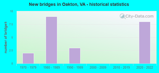
- New bridges - historical statistics
- 21970-1979
- 91980-1989
- 31990-1999
- 82020-2022


- Bridge Condition - Deck
- 33.3%Excellent
- 50.0%Good
- 16.7%Satisfactory

- Bridge Condition - Superstructure
- 33.3%Excellent
- 16.7%Good
- 33.3%Satisfactory
- 16.7%Fair

- Bridge Condition - Substructure
- 33.3%Excellent
- 33.3%Good
- 33.3%Satisfactory

- Bridge Condition - Channel
- 16.7%Good
- 33.3%Satisfactory
- 50.0%Fair

- Bridge Condition - Culverts
- 25.0%Good
- 50.0%Satisfactory
- 25.0%Fair
Find on map >> Show street view
Structure Number: 6492, Location: 00.40 29 / 01.21 123 (Lat: 38.877972, Lng: -77.266933), Route carried "on" structure: State highway 243, Year Built: 1989, Status: Open, Structure Length: 10.12m (33.20ft), Average Daily Traffic: 20,873 (year 2020), Truck Traffic: 1%, Average Future Daily Traffic: 22,960 (year 2040), Design Load: HS 20+Mod, Features Intersected: ROUTE 66 & METRO, Facility Carried by Structure: NUTLEY STREET
Minimum Vertical Clearance: 30+ m (98+ ft), Kilometerpoint: 0.724, Lanes on structure: 8, Lanes under structure: 12, Owner: State Highway Agency, Approaching Roadway Width: 18.3m (60.0ft), Skew: 21 degrees, Material/Design: Steel, Design/Construction: Stringer/Multi-beam, Number Of Spans In Main Unit: 3, Length of Maximum Span: 42.1m (138.1ft), Curb or Sidewalk Widths: Left: 2.6m (8.5ft), Right: 2.6m (8.5ft), Curb-To-Curb Width: 31.1m (102.0ft), Out-to-Out Width: 38.1m (125.0ft)
Condition: Deck: Satisfactory, Superstructure: Satisfactory, Substructure: Satisfactory, Operating Rating: 89.8 metric tons, Method Used To Determine Operating Rating: Load and Resistance Factor (LRFR), Inventory Rating: 87.1 metric tons, Method Used To Determine Inventory Rating: Load and Resistance Factor (LRFR), Structural Evaluation: Equal to present minimum criteria, Deck Geometry: Somewhat better than minimum adequacy, Underclear: Somewhat better than minimum adequacy, Approach Roadway Alignment: Equal to present desirable criteria, Length Of Structure Improvement: 3.05m (10.01ft), Designated Inspection Frequency: Every 24 months, Inspection Date: Febuary 2022, Bridge Improvement Cost: $150,000, Roadway Improvement Cost: $50,000, Total Project Cost: $225,000 ( Estimate for 2014), Deck Structure Type: Concrete Cast-file-Place, Wearing Surface/Protective System: Wearing Surface: Monolithic Concrete, Deck Protection: Epoxy Coated Reinforcing
Find on map >> Show street view
Structure Number: 6796, Location: 0.05FR701 0.15TO4949 (Lat: 38.875150, Lng: -77.283575), Route carried "on" structure: County highway 655, Year Built: 1990, Status: Open, Structure Length: 8.38m (27.49ft), Average Daily Traffic: 14,949 (year 2020), Truck Traffic: 2%, Average Future Daily Traffic: 17,753 (year 2040), Design Load: HS 20, Features Intersected: E.& W. BOUND RTE.66, Facility Carried by Structure: BLAKE LANE
Minimum Vertical Clearance: 30+ m (98+ ft), Kilometerpoint: 6.356, Lanes on structure: 5, Lanes under structure: 8, Owner: State Highway Agency, Approaching Roadway Width: 17.1m (56.1ft), Skew: 22 degrees, Material/Design: Steel continuous, Design/Construction: Stringer/Multi-beam, Number Of Spans In Main Unit: 2, Length of Maximum Span: 41.8m (137.1ft), Curb or Sidewalk Widths: Left: 1.5m (4.9ft), Right: 1.5m (4.9ft), Curb-To-Curb Width: 17.1m (56.1ft), Out-to-Out Width: 29.4m (96.5ft)
Condition: Deck: Good, Superstructure: Satisfactory, Substructure: Good, Operating Rating: 42.6 metric tons, Method Used To Determine Operating Rating: Load and Resistance Factor (LRFR), Inventory Rating: 32.7 metric tons, Method Used To Determine Inventory Rating: Load and Resistance Factor (LRFR), Structural Evaluation: Equal to present minimum criteria, Deck Geometry: High priority of replacement, Underclear: Equal to present minimum criteria, Approach Roadway Alignment: Equal to present desirable criteria, Length Of Structure Improvement: 8.38m (27.49ft), Designated Inspection Frequency: Every 24 months, Inspection Date: September 2020, Bridge Improvement Cost: $100,000, Roadway Improvement Cost: $100,000, Total Project Cost: $210,000 ( Estimate for 2014), Deck Structure Type: Concrete Cast-file-Place, Wearing Surface/Protective System: Wearing Surface: Monolithic Concrete, Deck Protection: Epoxy Coated Reinforcing
Find on map >> Show street view
Structure Number: 6814, Location: 00.00FR.664W/00.32TO664E (Lat: 38.874700, Lng: -77.337878), Route carried "on" structure: County highway 665, Year Built: 1970, Status: Posted for load, Structure Length: 0.98m (3.22ft), Average Daily Traffic: 4,057 (year 2020), Truck Traffic: 2%, Average Future Daily Traffic: 4,463 (year 2040), Design Load: HS 20, Features Intersected: DIFFICULT RUN, Facility Carried by Structure: WAPLES MILL ROAD
Minimum Vertical Clearance: 30+ m (98+ ft), Kilometerpoint: 13.023, Lanes on structure: 2, Owner: State Highway Agency, Approaching Roadway Width: 7.6m (24.9ft), Material/Design: Steel, Design/Construction: Culvert, Number Of Spans In Main Unit: 2, Length of Maximum Span: 4.6m (15.1ft)
Condition: Channel: Fair, Culverts: Satisfactory, Operating Rating: 36.3 metric tons, Method Used To Determine Operating Rating: Load Factor (LF), Inventory Rating: 32.7 metric tons, Method Used To Determine Inventory Rating: Load Factor (LF), Structural Evaluation: Equal to present minimum criteria, Waterway Adequacy: Better than present minimum criteria, Approach Roadway Alignment: Equal to present minimum criteria, Designated Inspection Frequency: Every 24 months, Inspection Date: August 2021
Find on map >> Show street view
Structure Number: 6826, Location: 00.07FR.7053/00.20TO2547 (Lat: 38.903506, Lng: -77.319083), Route carried "on" structure: County highway 672, Year Built: 1986, Status: Open, Structure Length: 4.63m (15.19ft), Average Daily Traffic: 5,392 (year 2020), Truck Traffic: 3%, Average Future Daily Traffic: 7,549 (year 2040), Design Load: HS 20, Features Intersected: DIFFICULT RUN, Facility Carried by Structure: VALE ROAD
Minimum Vertical Clearance: 30+ m (98+ ft), Kilometerpoint: 5.760, Lanes on structure: 2, Owner: State Highway Agency, Approaching Roadway Width: 12.8m (42.0ft), Skew: 3 degrees, Material/Design: Steel continuous, Design/Construction: Stringer/Multi-beam, Number Of Spans In Main Unit: 2, Length of Maximum Span: 23.2m (76.1ft), Curb or Sidewalk Widths: Left: 0.2m (0.7ft), Right: 0.2m (0.7ft), Curb-To-Curb Width: 12.2m (40.0ft), Out-to-Out Width: 13.1m (43.0ft)
Condition: Deck: Good, Superstructure: Good, Substructure: Good, Channel: Fair, Operating Rating: 44.1 metric tons, Method Used To Determine Operating Rating: Load and Resistance Factor (LRFR), Inventory Rating: 33.9 metric tons, Method Used To Determine Inventory Rating: Load and Resistance Factor (LRFR), Structural Evaluation: Better than present minimum criteria, Deck Geometry: Somewhat better than minimum adequacy, Waterway Adequacy: Better than present minimum criteria, Approach Roadway Alignment: Equal to present minimum criteria, Length Of Structure Improvement: 0.61m (2.00ft), Designated Inspection Frequency: Every 24 months, Inspection Date: July 2020, Bridge Improvement Cost: $100,000, Roadway Improvement Cost: $50,000, Total Project Cost: $250,000 ( Estimate for 2014), Deck Structure Type: Concrete Cast-file-Place, Wearing Surface/Protective System: Deck Protection: Epoxy Coated Reinforcing
Find on map >> Show street view
Structure Number: 6827, Location: .05 FR 7490 & .50 TO 674 (Lat: 38.923533, Lng: -77.312322), Route carried "on" structure: County highway 673, Year Built: 1985, Status: Open, Structure Length: 5.64m (18.50ft), Average Daily Traffic: 7,641 (year 2020), Truck Traffic: 1%, Average Future Daily Traffic: 10,697 (year 2040), Design Load: HS 20, Features Intersected: DIFFICULT RUN, Facility Carried by Structure: LAWYERS ROAD
Minimum Vertical Clearance: 30+ m (98+ ft), Kilometerpoint: 5.905, Lanes on structure: 2, Owner: State Highway Agency, Approaching Roadway Width: 12.2m (40.0ft), Material/Design: Steel, Design/Construction: Stringer/Multi-beam, Number Of Spans In Main Unit: 3, Length of Maximum Span: 18.9m (62.0ft), Curb or Sidewalk Widths: Left: 0.2m (0.7ft), Right: 0.2m (0.7ft), Curb-To-Curb Width: 11.7m (38.4ft), Out-to-Out Width: 12.7m (41.7ft)
Condition: Deck: Good, Superstructure: Fair, Substructure: Satisfactory, Channel: Fair, Inventory Rating: 71.7 metric tons, Method Used To Determine Inventory Rating: Load and Resistance Factor (LRFR), Structural Evaluation: Somewhat better than minimum adequacy, Deck Geometry: Somewhat better than minimum adequacy, Waterway Adequacy: Better than present minimum criteria, Approach Roadway Alignment: Equal to present minimum criteria, Length Of Structure Improvement: 1.52m (4.99ft), Designated Inspection Frequency: Every 24 months, Inspection Date: January 2021, Bridge Improvement Cost: $100,000, Roadway Improvement Cost: $100,000, Total Project Cost: $205,000 ( Estimate for 2015), Deck Structure Type: Concrete Cast-file-Place, Wearing Surface/Protective System: Deck Protection: Epoxy Coated Reinforcing
Find on map >> Show street view
Structure Number: 6895, Location: 00.08FR655/00.07TOEND (Lat: 38.874972, Lng: -77.287931), Route carried "on" structure: County highway 783, Year Built: 1984, Status: Posted for load, Structure Length: 1.04m (3.41ft), Average Daily Traffic: 674 (year 2011), Average Future Daily Traffic: 772 (year 2040), Design Load: HS 20, Features Intersected: TRIB.OF ACCOTINK CREEK, Facility Carried by Structure: PLATTEN DRIVE
Minimum Vertical Clearance: 30+ m (98+ ft), Kilometerpoint: 0.097, Lanes on structure: 2, Owner: State Highway Agency, Approaching Roadway Width: 10.7m (35.1ft), Skew: 4 degrees, Material/Design: Steel, Design/Construction: Culvert, Number Of Spans In Main Unit: 3, Length of Maximum Span: 2.7m (8.9ft)
Condition: Channel: Good, Culverts: Fair, Operating Rating: 36.3 metric tons, Method Used To Determine Operating Rating: Load Factor (LF), Inventory Rating: 32.7 metric tons, Method Used To Determine Inventory Rating: Load Factor (LF), Structural Evaluation: Somewhat better than minimum adequacy, Waterway Adequacy: Equal to present minimum criteria, Approach Roadway Alignment: Equal to present minimum criteria, Length Of Structure Improvement: 6.04m (19.82ft), Designated Inspection Frequency: Every 24 months, Inspection Date: April 2021, Bridge Improvement Cost: $29,000, Roadway Improvement Cost: $44,000, Total Project Cost: $100,000 ( Estimate for 2015)
Find on map >> Show street view
Structure Number: 6994, Location: 00.20FR.6474/00.20TO4385 (Lat: 38.896469, Lng: -77.315703), Route carried "on" structure: County highway 4382, Year Built: 1984, Status: Open, Structure Length: 0.82m (2.69ft), Average Daily Traffic: 141 (year 2015), Average Future Daily Traffic: 159 (year 2040), Design Load: HS 20+Mod, Features Intersected: TRIBUTARY OF ROCKY BR., Facility Carried by Structure: SAMAGA DRIVE
Minimum Vertical Clearance: 30+ m (98+ ft), Kilometerpoint: 0.394, Lanes on structure: 2, Owner: State Highway Agency, Approaching Roadway Width: 6.4m (21.0ft), Material/Design: Concrete, Design/Construction: Culvert, Number Of Spans In Main Unit: 3, Length of Maximum Span: 2.7m (8.9ft)
Condition: Channel: Satisfactory, Culverts: Good, Operating Rating: 89.8 metric tons, Method Used To Determine Operating Rating: Load Factor (LF), Inventory Rating: 58.1 metric tons, Method Used To Determine Inventory Rating: Load Factor (LF), Structural Evaluation: Better than present minimum criteria, Waterway Adequacy: Equal to present desirable criteria, Approach Roadway Alignment: Equal to present minimum criteria, Length Of Structure Improvement: 0.30m (0.98ft), Designated Inspection Frequency: Every 24 months, Inspection Date: June 2020, Bridge Improvement Cost: $1,000, Roadway Improvement Cost: $1,000, Total Project Cost: $3,000
Find on map >> Show street view
Structure Number: 7034, Location: 0.08FR1051 0.20TOE.S.MNT (Lat: 38.868536, Lng: -77.282978), Route carried "on" structure: County highway 4909, Year Built: 1977, Status: Open, Structure Length: 0.70m (2.30ft), Average Daily Traffic: 2,745 (year 2015), Average Future Daily Traffic: 3,088 (year 2040), Design Load: HS 20, Features Intersected: BRANCH ACCOTINK CREEK, Facility Carried by Structure: KINGSBRIDGE DR.
Minimum Vertical Clearance: 30+ m (98+ ft), Kilometerpoint: 0.444, Lanes on structure: 2, Owner: State Highway Agency, Approaching Roadway Width: 13.4m (44.0ft), Skew: 3 degrees, Material/Design: Concrete, Design/Construction: Culvert, Number Of Spans In Main Unit: 2, Length of Maximum Span: 3.4m (11.2ft)
Condition: Channel: Satisfactory, Culverts: Satisfactory, Operating Rating: 87.1 metric tons, Method Used To Determine Operating Rating: Load Factor (LF), Inventory Rating: 51.7 metric tons, Method Used To Determine Inventory Rating: Load Factor (LF), Structural Evaluation: Equal to present minimum criteria, Waterway Adequacy: Somewhat better than minimum adequacy, Approach Roadway Alignment: Equal to present desirable criteria, Length Of Structure Improvement: 4.60m (15.09ft), Designated Inspection Frequency: Every 24 months, Inspection Date: January 2021, Bridge Improvement Cost: $33,000, Roadway Improvement Cost: $54,000, Total Project Cost: $100,000
Find on map >> Show street view
Structure Number: 30946, Location: 00.07fr4949 00.09to6154 (Lat: 38.876714, Lng: -77.274928), Route carried "on" structure: County highway 6731, Year Built: 2020, Status: Open, Structure Length: 12.68m (41.60ft), Average Daily Traffic: 810 (year 2015), Average Future Daily Traffic: 1,215 (year 2040), Design Load: HL 93, Features Intersected: I-66, Facility Carried by Structure: VADEN DRIVE
Minimum Vertical Clearance: 30.18m (99.02ft), Kilometerpoint: 0.000, Lanes on structure: 5, Lanes under structure: 13, Owner: State Highway Agency, Approaching Roadway Width: 8.2m (26.9ft), Skew: 2 degrees, Material/Design: Steel continuous, Design/Construction: Stringer/Multi-beam, Number Of Spans In Main Unit: 3, Length of Maximum Span: 50.6m (166.0ft), Curb or Sidewalk Widths: Left: 2.0m (6.6ft), Right: 3.0m (9.8ft), Curb-To-Curb Width: 7.3m (24.0ft), Out-to-Out Width: 29.0m (95.1ft)
Condition: Deck: Excellent, Superstructure: Excellent, Substructure: Excellent, Operating Rating: 79.0 metric tons, Method Used To Determine Operating Rating: Load and Resistance Factor (LRFR), Inventory Rating: 61.1 metric tons, Method Used To Determine Inventory Rating: Load and Resistance Factor (LRFR), Structural Evaluation: Superior to present desirable criteria, Deck Geometry: High priority of replacement, Underclear: Somewhat better than minimum adequacy, Approach Roadway Alignment: Equal to present desirable criteria, Designated Inspection Frequency: Every 24 months, Inspection Date: November 2020, Deck Structure Type: Concrete Cast-file-Place, Wearing Surface/Protective System: Wearing Surface: Monolithic Concrete, Deck Protection: Other
Find on map >> Show street view
Structure Number: 30947, Location: 00.70fr50 00.60to655 (Lat: 38.868389, Lng: -77.308225), Route carried "on" structure: US 123, Year Built: 2020, Status: Open, Structure Length: 12.89m (42.29ft), Average Daily Traffic: 8,711 (year 2020), Average Future Daily Traffic: 9,583 (year 2040), Design Load: HL 93, Features Intersected: I-66, Facility Carried by Structure: CHAINBRIDGE ROAD
Minimum Vertical Clearance: 5.64m (18.50ft), Kilometerpoint: 101.389, Lanes on structure: 8, Lanes under structure: 12, Owner: State Highway Agency, Approaching Roadway Width: 14.3m (46.9ft), Skew: 21 degrees, Material/Design: Concrete, Design/Construction: Stringer/Multi-beam, Number Of Spans In Main Unit: 3, Length of Maximum Span: 45.1m (148.0ft), Curb or Sidewalk Widths: Left: 4.3m (14.1ft), Right: 0.0m, Curb-To-Curb Width: 11.0m (36.1ft), Out-to-Out Width: 46.6m (152.9ft)
Condition: Deck: Excellent, Superstructure: Excellent, Substructure: Excellent, Operating Rating: 80.6 metric tons, Method Used To Determine Operating Rating: Load and Resistance Factor (LRFR), Inventory Rating: 53.4 metric tons, Method Used To Determine Inventory Rating: Load and Resistance Factor (LRFR), Structural Evaluation: Superior to present desirable criteria, Deck Geometry: High priority of replacement, Underclear: High priority of corrective action, Approach Roadway Alignment: Equal to present desirable criteria, Designated Inspection Frequency: Every 24 months, Inspection Date: December 2020, Deck Structure Type: Concrete Cast-file-Place, Wearing Surface/Protective System: Wearing Surface: Monolithic Concrete, Deck Protection: Other
Find on map >> Show street view
Structure Number: 6492, Location: 00.40 29 / 01.21 123 (Lat: 38.877972, Lng: -77.266933), Route carried "under" structure: Ramp Interstate 66, Year Built: 1989, Structure Length: 0. m, Average Daily Traffic: 20,000 (year 1994), Truck Traffic: 3%, Features Intersected: ROUTE 66 & METRO, Facility Carried by Structure: NUTLEY STREET
Minimum Vertical Clearance: 5.11m (16.77ft), Kilometerpoint: 1.126, Lanes on structure: 8, Lanes under structure: 2, Material/Design: Steel, Design/Construction: Stringer/Multi-beam, Length of Maximum Span: 42.1m (138.1ft)
Find on map >> Show street view
Structure Number: 6492, Location: 00.40 29 / 01.21 123 (Lat: 38.877972, Lng: -77.266933), Route carried "under" structure: Interstate 66, Year Built: 1989, Structure Length: 0. m, Average Daily Traffic: 55,000 (year 1994), Features Intersected: ROUTE 66 & METRO, Facility Carried by Structure: NUTLEY STREET
Minimum Vertical Clearance: 5.05m (16.57ft), Kilometerpoint: 100.611, Lanes on structure: 8, Lanes under structure: 4, Material/Design: Steel, Design/Construction: Stringer/Multi-beam, Length of Maximum Span: 42.1m (138.1ft)
Find on map >> Show street view
Structure Number: 6492, Location: 00.40 29 / 01.21 123 (Lat: 38.877972, Lng: -77.266933), Route carried "under" structure: Interstate 66, Year Built: 1989, Structure Length: 0. m, Average Daily Traffic: 171,499 (year 2008), Truck Traffic: 1%, Features Intersected: ROUTE 66 & METRO, Facility Carried by Structure: NUTLEY STREET
Minimum Vertical Clearance: 5.28m (17.32ft), Kilometerpoint: 100.032, Lanes on structure: 8, Lanes under structure: 4, Material/Design: Steel, Design/Construction: Stringer/Multi-beam, Length of Maximum Span: 42.1m (138.1ft)
Find on map >> Show street view
Structure Number: 6492, Location: 00.40 29 / 01.21 123 (Lat: 38.877972, Lng: -77.266933), Route carried "under" structure: Ramp Interstate 66, Year Built: 1989, Structure Length: 0. m, Average Daily Traffic: 20,000 (year 1994), Features Intersected: ROUTE 66 & METRO, Facility Carried by Structure: NUTLEY STREET
Minimum Vertical Clearance: 5.41m (17.75ft), Kilometerpoint: 1.110, Lanes on structure: 8, Lanes under structure: 2, Material/Design: Steel, Design/Construction: Stringer/Multi-beam, Length of Maximum Span: 42.1m (138.1ft)
Find on map >> Show street view
Structure Number: 6796, Location: 0.05FR701 0.15TO4949 (Lat: 38.875150, Lng: -77.283575), Route carried "under" structure: Interstate 66, Year Built: 1990, Structure Length: 0. m, Average Daily Traffic: 184,175 (year 2008), Truck Traffic: 1%, Features Intersected: E.& W. BOUND RTE.66, Facility Carried by Structure: BLAKE LANE
Minimum Vertical Clearance: 5.13m (16.83ft), Kilometerpoint: 98.567, Lanes on structure: 5, Lanes under structure: 4, Material/Design: Steel continuous, Design/Construction: Stringer/Multi-beam, Length of Maximum Span: 41.8m (137.1ft)
Find on map >> Show street view
Structure Number: 6796, Location: 0.05FR701 0.15TO4949 (Lat: 38.875150, Lng: -77.283575), Route carried "under" structure: Interstate 66, Year Built: 1990, Structure Length: 0. m, Average Daily Traffic: 117,420 (year 1994), Features Intersected: E.& W. BOUND RTE.66, Facility Carried by Structure: BLAKE LANE
Minimum Vertical Clearance: 5.36m (17.59ft), Kilometerpoint: 98.535, Lanes on structure: 5, Lanes under structure: 4, Material/Design: Steel continuous, Design/Construction: Stringer/Multi-beam, Length of Maximum Span: 41.8m (137.1ft)
Find on map >> Show street view
Structure Number: 30946, Location: 00.07fr4949 00.09to6154 (Lat: 38.876714, Lng: -77.274928), Route carried "under" structure: Interstate 66, Year Built: 2020, Structure Length: 0. m, Features Intersected: I-66, Facility Carried by Structure: VADEN DRIVE
Minimum Vertical Clearance: 5.87m (19.26ft), Kilometerpoint: 0.000, Lanes on structure: 5, Lanes under structure: 2, Material/Design: Steel continuous, Design/Construction: Stringer/Multi-beam, Length of Maximum Span: 50.6m (166.0ft)
Find on map >> Show street view
Structure Number: 30946, Location: 00.07fr4949 00.09to6154 (Lat: 38.876714, Lng: -77.274928), Route carried "under" structure: Interstate 66, Year Built: 2020, Structure Length: 0. m, Features Intersected: I-66, Facility Carried by Structure: VADEN DRIVE
Minimum Vertical Clearance: 6.65m (21.82ft), Kilometerpoint: 0.000, Lanes on structure: 5, Lanes under structure: 2, Material/Design: Steel continuous, Design/Construction: Stringer/Multi-beam, Length of Maximum Span: 50.6m (166.0ft)
Find on map >> Show street view
Structure Number: 30947, Location: 00.70fr50 00.60to655 (Lat: 38.868389, Lng: -77.308225), Route carried "under" structure: Ramp Interstate 66, Year Built: 2020, Structure Length: 0. m, Features Intersected: I-66, Facility Carried by Structure: CHAINBRIDGE ROAD
Minimum Vertical Clearance: 6.20m (20.34ft), Kilometerpoint: 0.000, Lanes on structure: 8, Lanes under structure: 1, Material/Design: Concrete, Design/Construction: Stringer/Multi-beam, Length of Maximum Span: 45.1m (148.0ft)
Find on map >> Show street view
Structure Number: 30947, Location: 00.70fr50 00.60to655 (Lat: 38.868389, Lng: -77.308225), Route carried "under" structure: Interstate 66, Year Built: 2020, Structure Length: 0. m, Features Intersected: I-66, Facility Carried by Structure: CHAINBRIDGE ROAD
Minimum Vertical Clearance: 5.05m (16.57ft), Kilometerpoint: 0.000, Lanes on structure: 8, Lanes under structure: 5, Material/Design: Concrete, Design/Construction: Stringer/Multi-beam, Length of Maximum Span: 45.1m (148.0ft)
Find on map >> Show street view
Structure Number: 30947, Location: 00.70fr50 00.60to655 (Lat: 38.868389, Lng: -77.308225), Route carried "under" structure: Interstate 66, Year Built: 2020, Structure Length: 0. m, Features Intersected: I-66, Facility Carried by Structure: CHAINBRIDGE ROAD
Minimum Vertical Clearance: 5.61m (18.41ft), Kilometerpoint: 0.000, Lanes on structure: 8, Lanes under structure: 5, Material/Design: Concrete, Design/Construction: Stringer/Multi-beam, Length of Maximum Span: 45.1m (148.0ft)
Find on map >> Show street view
Structure Number: 30947, Location: 00.70fr50 00.60to655 (Lat: 38.868389, Lng: -77.308225), Route carried "under" structure: Ramp Interstate 66, Year Built: 2020, Structure Length: 0. m, Features Intersected: I-66, Facility Carried by Structure: CHAINBRIDGE ROAD
Minimum Vertical Clearance: 5.36m (17.59ft), Kilometerpoint: 0.000, Lanes on structure: 8, Lanes under structure: 1, Material/Design: Concrete, Design/Construction: Stringer/Multi-beam, Length of Maximum Span: 45.1m (148.0ft)