Bridge Statistics for Oakland, Florida (FL)
Condition, Traffic, Stress, Structural Evaluation, Project Costs
- National Bridge Inventory (NBI) Statistics
- 15Number of bridges
- 121ft / 36.9mTotal length
- $112,000Total costs
- 662,800Total average daily traffic
- 98,893Total average daily truck traffic
- National Bridge Inventory (NBI) Registered Bridges for Oakland
- No street view available for this location
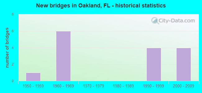
- New bridges - historical statistics
- 11950-1959
- 61960-1969
- 41990-1999
- 42000-2009

- Reconstructed bridges - Historical Statistics
- 12000-2009
- 22010-2019


- Bridge Condition - Deck
- 14.3%Very good
- 71.4%Good
- 14.3%Satisfactory
Find on map >> Show street view
Structure Number: 750188, Location: 1 MI N OF SR 50 INT (Lat: 28.553031, Lng: -81.653728), Route carried "on" structure: State highway 91, Year Built: 1964, Status: Open, Structure Length: 3.70m (12.14ft), Average Daily Traffic: 30,550 (year 2020), Truck Traffic: 21%, Average Future Daily Traffic: 53,004 (year 2042), Design Load: H 20, Features Intersected: JONES RD
Minimum Vertical Clearance: 30+ m (98+ ft), Kilometerpoint: 39.722, Lanes on structure: 2, Lanes under structure: 2, Base Highway Network: Yes, Toll: On toll road, Owner: State Toll Authority, Approaching Roadway Width: 11.6m (38.1ft), Skew: 1 degrees, Material/Design: Prestressed concrete, Design/Construction: Stringer/Multi-beam, Number Of Spans In Main Unit: 3, Length of Maximum Span: 13.9m (45.6ft), Curb-To-Curb Width: 11.6m (38.1ft), Out-to-Out Width: 13.5m (44.3ft)
Condition: Deck: Satisfactory, Superstructure: Good, Substructure: Good, Operating Rating: 48.4 metric tons, Method Used To Determine Operating Rating: Load and Resistance Factor (LRFR), Inventory Rating: 37.4 metric tons, Method Used To Determine Inventory Rating: Load and Resistance Factor (LRFR), Structural Evaluation: Better than present minimum criteria, Deck Geometry: Equal to present minimum criteria, Underclear: Meets minimum limits, Approach Roadway Alignment: Equal to present desirable criteria, Designated Inspection Frequency: Every 24 months, Inspection Date: October 2021, Deck Structure Type: Concrete Cast-file-Place
Find on map >> Show street view
Structure Number: 750282, Location: 1 MI N OF SR 50 INT (Lat: 28.553211, Lng: -81.653756), Route carried "on" structure: State highway 91, Year Built: 1964, Status: Open, Structure Length: 3.70m (12.14ft), Average Daily Traffic: 30,550 (year 2020), Truck Traffic: 21%, Average Future Daily Traffic: 53,004 (year 2042), Design Load: H 20, Features Intersected: JONES RD
Minimum Vertical Clearance: 30+ m (98+ ft), Kilometerpoint: 39.730, Lanes on structure: 2, Lanes under structure: 2, Base Highway Network: Yes, Toll: On toll road, Owner: State Toll Authority, Approaching Roadway Width: 11.5m (37.7ft), Skew: 1 degrees, Material/Design: Prestressed concrete, Design/Construction: Stringer/Multi-beam, Number Of Spans In Main Unit: 3, Length of Maximum Span: 13.9m (45.6ft), Curb-To-Curb Width: 11.5m (37.7ft), Out-to-Out Width: 13.4m (44.0ft)
Condition: Deck: Good, Superstructure: Good, Substructure: Good, Operating Rating: 48.4 metric tons, Method Used To Determine Operating Rating: Load and Resistance Factor (LRFR), Inventory Rating: 37.4 metric tons, Method Used To Determine Inventory Rating: Load and Resistance Factor (LRFR), Structural Evaluation: Better than present minimum criteria, Deck Geometry: Somewhat better than minimum adequacy, Underclear: Meets minimum limits, Approach Roadway Alignment: Equal to present desirable criteria, Designated Inspection Frequency: Every 24 months, Inspection Date: October 2021, Deck Structure Type: Concrete Cast-file-Place
Find on map >> Show street view
Structure Number: 750404, Location: 1.2 MI N of CR 545 (Lat: 28.548936, Lng: -81.638644), Route carried "on" structure: State highway 91, Year Built: 1992, Year Reconstructed: 2010, Status: Open, Structure Length: 7.12m (23.36ft), Average Daily Traffic: 47,000 (year 2020), Truck Traffic: 21%, Average Future Daily Traffic: 81,545 (year 2042), Design Load: HL 93, Features Intersected: SR 50
Minimum Vertical Clearance: 30+ m (98+ ft), Kilometerpoint: 38.158, Lanes on structure: 4, Lanes under structure: 9, Base Highway Network: Yes, Toll: On toll road, Owner: State Toll Authority, Approaching Roadway Width: 20.7m (67.9ft), Skew: 3 degrees, Material/Design: Prestressed concrete, Design/Construction: Stringer/Multi-beam, Number Of Spans In Main Unit: 2, Length of Maximum Span: 35.7m (117.1ft), Curb-To-Curb Width: 20.7m (67.9ft), Out-to-Out Width: 21.7m (71.2ft)
Condition: Deck: Good, Superstructure: Good, Substructure: Good, Operating Rating: 48.1 metric tons, Method Used To Determine Operating Rating: Load and Resistance Factor (LRFR), Inventory Rating: 37.1 metric tons, Method Used To Determine Inventory Rating: Load and Resistance Factor (LRFR), Structural Evaluation: Better than present minimum criteria, Deck Geometry: Equal to present minimum criteria, Underclear: Somewhat better than minimum adequacy, Approach Roadway Alignment: Equal to present desirable criteria, Designated Inspection Frequency: Every 24 months, Inspection Date: October 2021, Deck Structure Type: Concrete Cast-file-Place
Find on map >> Show street view
Structure Number: 750405, Location: 1.2 MI N of CR 545 (Lat: 28.549119, Lng: -81.638461), Route carried "on" structure: State highway 91, Year Built: 1992, Year Reconstructed: 2010, Status: Open, Structure Length: 7.13m (23.39ft), Average Daily Traffic: 47,000 (year 2020), Truck Traffic: 21%, Average Future Daily Traffic: 81,545 (year 2042), Design Load: HL 93, Features Intersected: SR 50
Minimum Vertical Clearance: 30+ m (98+ ft), Kilometerpoint: 38.141, Lanes on structure: 3, Lanes under structure: 9, Base Highway Network: Yes, Toll: On toll road, Owner: State Toll Authority, Approaching Roadway Width: 20.7m (67.9ft), Skew: 3 degrees, Material/Design: Prestressed concrete, Design/Construction: Stringer/Multi-beam, Number Of Spans In Main Unit: 2, Length of Maximum Span: 35.7m (117.1ft), Curb-To-Curb Width: 20.7m (67.9ft), Out-to-Out Width: 21.7m (71.2ft)
Condition: Deck: Good, Superstructure: Good, Substructure: Good, Operating Rating: 47.9 metric tons, Method Used To Determine Operating Rating: Load and Resistance Factor (LRFR), Inventory Rating: 36.9 metric tons, Method Used To Determine Inventory Rating: Load and Resistance Factor (LRFR), Structural Evaluation: Better than present minimum criteria, Deck Geometry: Superior to present desirable criteria, Underclear: Somewhat better than minimum adequacy, Approach Roadway Alignment: Equal to present desirable criteria, Designated Inspection Frequency: Every 24 months, Inspection Date: October 2021, Deck Structure Type: Concrete Cast-file-Place
Find on map >> Show street view
Structure Number: 750606, Location: 1.4 miles S OF SR 438 (Lat: 28.551406, Lng: -81.559067), Route carried "on" structure: Ramp State highway 429, Year Built: 2001, Status: Open, Structure Length: 5.35m (17.55ft), Average Daily Traffic: 10,500 (year 2020), Truck Traffic: 21%, Average Future Daily Traffic: 18,218 (year 2042), Design Load: HS 20, Features Intersected: SR 50
Minimum Vertical Clearance: 30+ m (98+ ft), Kilometerpoint: 0.000, Lanes on structure: 2, Lanes under structure: 8, Toll: On toll road, Owner: State Toll Authority, Approaching Roadway Width: 11.8m (38.7ft), Material/Design: Steel, Design/Construction: Stringer/Multi-beam, Number Of Spans In Main Unit: 1, Length of Maximum Span: 53.5m (175.5ft), Curb-To-Curb Width: 11.8m (38.7ft), Out-to-Out Width: 13.1m (43.0ft)
Condition: Deck: Good, Superstructure: Good, Substructure: Good, Operating Rating: 59.9 metric tons, Method Used To Determine Operating Rating: Load Factor (LF), Inventory Rating: 35.4 metric tons, Method Used To Determine Inventory Rating: Load Factor (LF), Structural Evaluation: Better than present minimum criteria, Deck Geometry: Superior to present desirable criteria, Underclear: Superior to present desirable criteria, Approach Roadway Alignment: Equal to present desirable criteria, Designated Inspection Frequency: Every 24 months, Inspection Date: October 2021, Deck Structure Type: Concrete Cast-file-Place
Find on map >> Show street view
Structure Number: 754135, Location: .15mi. South of SR-50 (Lat: 28.548314, Lng: -81.627817), Route carried "on" structure: County highway , Year Built: 2006, Status: Open, Structure Length: 7.07m (23.20ft), Average Daily Traffic: 1,500 (year 2021), Truck Traffic: 1%, Average Future Daily Traffic: 2,602 (year 2042), Design Load: HL 93, Features Intersected: SR-91 Turnpike, Facility Carried by Structure: 4th Street
Minimum Vertical Clearance: 30+ m (98+ ft), Kilometerpoint: 0.000, Lanes on structure: 2, Lanes under structure: 8, Owner: County Highway Agency, Approaching Roadway Width: 9.7m (31.8ft), Skew: 1 degrees, Material/Design: Steel continuous, Design/Construction: Stringer/Multi-beam, Number Of Spans In Main Unit: 2, Length of Maximum Span: 35.4m (116.1ft), Curb-To-Curb Width: 9.7m (31.8ft), Out-to-Out Width: 10.8m (35.4ft)
Condition: Deck: Very good, Superstructure: Good, Substructure: Good, Operating Rating: 67.3 metric tons, Method Used To Determine Operating Rating: Load Factor (LF), Inventory Rating: 40.2 metric tons, Method Used To Determine Inventory Rating: Load Factor (LF), Structural Evaluation: Better than present minimum criteria, Deck Geometry: Somewhat better than minimum adequacy, Underclear: Equal to present minimum criteria, Approach Roadway Alignment: Better than present minimum criteria, Designated Inspection Frequency: Every 24 months, Inspection Date: Febuary 2021, Deck Structure Type: Concrete Cast-file-Place
Find on map >> Show street view
Structure Number: 86018, Location: 0.6 MI NORTH OF SR-816 (Lat: 26.172831, Lng: -80.219939), Route carried "on" structure: State highway 91, Year Built: 1956, Year Reconstructed: 2011, Status: Open, Structure Length: 2.78m (9.12ft), Average Daily Traffic: 121,800 (year 2021), Truck Traffic: 13%, Average Future Daily Traffic: 211,323 (year 2042), Design Load: HS 20, Features Intersected: MID RIVER CANAL
Minimum Vertical Clearance: 30+ m (98+ ft), Kilometerpoint: 22.718, Lanes on structure: 8, Base Highway Network: Yes, Toll: On toll road, Owner: State Toll Authority, Approaching Roadway Width: 40.2m (131.9ft), Skew: 30 degrees, Material/Design: Concrete, Design/Construction: Slab, Number Of Spans In Main Unit: 3, Length of Maximum Span: 9.4m (30.8ft), Curb-To-Curb Width: 42.7m (140.1ft), Out-to-Out Width: 44.2m (145.0ft)
Condition: Deck: Good, Superstructure: Good, Substructure: Good, Channel: Good, Operating Rating: 60.3 metric tons, Method Used To Determine Operating Rating: Load Factor (LF), Inventory Rating: 36.2 metric tons, Method Used To Determine Inventory Rating: Load Factor (LF), Structural Evaluation: Better than present minimum criteria, Deck Geometry: Superior to present desirable criteria, Waterway Adequacy: Equal to present desirable criteria, Approach Roadway Alignment: Equal to present desirable criteria, Length Of Structure Improvement: 2.77m (9.09ft), Designated Inspection Frequency: Every 24 months, Underwater Inspection Frequency: Every 24 months, Inspection Date: September 2021, Underwater Inspection Date: September 2021, Bridge Improvement Cost: $112,000, Total Project Cost: $112,000, Deck Structure Type: Concrete Cast-file-Place, Wearing Surface/Protective System: Wearing Surface: Bituminous, Membrane: Built-up
Find on map >> Show street view
Structure Number: 750188, Location: 1 MI N OF SR 50 INT (Lat: 28.553031, Lng: -81.653728), Route carried "under" structure: County highway , Year Built: 1964, Structure Length: 0. m, Average Daily Traffic: 30,550 (year 2020), Truck Traffic: 21%, Features Intersected: JONES RD, Facility Carried by Structure: SR 91 TPK SB 274.1
Minimum Vertical Clearance: 4.85m (15.91ft), Kilometerpoint: 0.000, Lanes on structure: 2, Lanes under structure: 2, Material/Design: Prestressed concrete, Design/Construction: Stringer/Multi-beam, Length of Maximum Span: 13.9m (45.6ft)
Find on map >> Show street view
Structure Number: 750282, Location: 1 MI N OF SR 50 INT (Lat: 28.553211, Lng: -81.653756), Route carried "under" structure: County highway , Year Built: 1964, Structure Length: 0. m, Average Daily Traffic: 30,550 (year 2020), Truck Traffic: 21%, Features Intersected: JONES RD, Facility Carried by Structure: SR 91 TPK NB 274.1
Minimum Vertical Clearance: 5.03m (16.50ft), Kilometerpoint: 0.000, Lanes on structure: 2, Lanes under structure: 2, Material/Design: Prestressed concrete, Design/Construction: Stringer/Multi-beam, Length of Maximum Span: 13.9m (45.6ft)
Find on map >> Show street view
Structure Number: 750404, Location: 1.2 MI N of CR 545 (Lat: 28.548936, Lng: -81.638644), Route carried "under" structure: State highway 50, Year Built: 1992, Structure Length: 0. m, Average Daily Traffic: 54,500 (year 2020), Truck Traffic: 5%, Features Intersected: SR 50, Facility Carried by Structure: SR 91 TPK SB 273.2
Minimum Vertical Clearance: 6.04m (19.82ft), Kilometerpoint: 1.912, Lanes on structure: 4, Lanes under structure: 9, Material/Design: Prestressed concrete, Design/Construction: Stringer/Multi-beam, Length of Maximum Span: 35.7m (117.1ft)
Find on map >> Show street view
Structure Number: 750405, Location: 1.2 MI N of CR 545 (Lat: 28.549119, Lng: -81.638461), Route carried "under" structure: State highway 50, Year Built: 1992, Structure Length: 0. m, Average Daily Traffic: 54,500 (year 2020), Truck Traffic: 5%, Features Intersected: SR 50, Facility Carried by Structure: SR 91 TPK NB 273.2
Minimum Vertical Clearance: 5.52m (18.11ft), Kilometerpoint: 1.941, Lanes on structure: 3, Lanes under structure: 9, Material/Design: Prestressed concrete, Design/Construction: Stringer/Multi-beam, Length of Maximum Span: 35.7m (117.1ft)
Find on map >> Show street view
Structure Number: 750606, Location: 1.4 miles S OF SR 438 (Lat: 28.551406, Lng: -81.559067), Route carried "under" structure: State highway 50, Year Built: 2001, Structure Length: 0. m, Average Daily Traffic: 51,500 (year 2020), Truck Traffic: 5%, Features Intersected: SR 50, Facility Carried by Structure: SR429 SB RMP
Minimum Vertical Clearance: 5.18m (16.99ft), Kilometerpoint: 9.733, Lanes on structure: 2, Lanes under structure: 8, Material/Design: Steel, Design/Construction: Stringer/Multi-beam, Length of Maximum Span: 53.5m (175.5ft)
Find on map >> Show street view
Structure Number: 7541, Location: SR-91 - 0.5 Mi N of SR-50 (Lat: 28.551111, Lng: -81.646389), Route carried "under" structure: Interstate 91, Year Built: 1963, Structure Length: 0. m, Average Daily Traffic: 66,600 (year 2021), Truck Traffic: 18%, Features Intersected: SR-91 Pedestrian Overpas, Facility Carried by Structure: West Orange Trail
Minimum Vertical Clearance: 5.00m (16.40ft), Kilometerpoint: 38.940, Lanes under structure: 5, Toll: On toll road, Material/Design: Prestressed concrete, Design/Construction: Stringer/Multi-beam, Length of Maximum Span: 20.9m (68.6ft)
Find on map >> Show street view
Structure Number: 7541, Location: SR-91 - 0.5 Mi N of SR-50 (Lat: 28.551111, Lng: -81.646389), Route carried "under" structure: Ramp Interstate 91, Year Built: 1963, Structure Length: 0. m, Average Daily Traffic: 1,300 (year 2021), Truck Traffic: 18%, Features Intersected: SR-91 Pedestrian Overpas, Facility Carried by Structure: West Orange Trail
Minimum Vertical Clearance: 5.27m (17.29ft), Kilometerpoint: 0.782, Lanes under structure: 1, Toll: On toll road, Material/Design: Prestressed concrete, Design/Construction: Stringer/Multi-beam, Length of Maximum Span: 20.9m (68.6ft)
Find on map >> Show street view
Structure Number: 754135, Location: .15mi. South of SR-50 (Lat: 28.548314, Lng: -81.627817), Route carried "under" structure: State highway 91, Year Built: 2006, Structure Length: 0. m, Average Daily Traffic: 84,400 (year 2021), Truck Traffic: 18%, Features Intersected: SR-91 Turnpike, Facility Carried by Structure: 4th Street
Minimum Vertical Clearance: 5.36m (17.59ft), Kilometerpoint: 37.132, Lanes on structure: 2, Lanes under structure: 8, Toll: On toll road, Material/Design: Steel continuous, Design/Construction: Stringer/Multi-beam, Length of Maximum Span: 35.4m (116.1ft)