Bridge Statistics for Oakford, Illinois (IL)
Condition, Traffic, Stress, Structural Evaluation, Project Costs
- National Bridge Inventory (NBI) Statistics
- 12Number of bridges
- 210ft / 63.6mTotal length
- $252,000Total costs
- 6,375Total average daily traffic
- 695Total average daily truck traffic
- 6,317Total future (year 2032) average daily traffic
- National Bridge Inventory (NBI) Registered Bridges for Oakford
- No street view available for this location
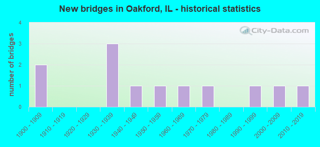
- New bridges - historical statistics
- 21900-1909
- 31930-1939
- 11940-1949
- 11950-1959
- 11960-1969
- 11970-1979
- 11990-1999
- 12000-2009
- 12010-2019

- Reconstructed bridges - Historical Statistics
- 11960-1969
- 11970-1979
- 21980-1989
- 11990-1999


- Bridge Condition - Deck
- 27.3%Very good
- 27.3%Good
- 18.2%Satisfactory
- 9.1%Fair
- 9.1%Poor
- 9.1%Failed

- Bridge Condition - Superstructure
- 18.2%Very good
- 27.3%Good
- 27.3%Satisfactory
- 9.1%Fair
- 9.1%Poor
- 9.1%Failed

- Bridge Condition - Substructure
- 18.2%Very good
- 27.3%Good
- 27.3%Satisfactory
- 9.1%Fair
- 9.1%Poor
- 9.1%Failed

- Bridge Condition - Channel
- 33.3%Very good
- 8.3%Good
- 50.0%Satisfactory
- 8.3%Poor
Find on map >> Show street view
Structure Number: 650002, Location: MASON MENARD CO LINE (Lat: 40.123853, Lng: -89.984500), Route carried "on" structure: State highway 97, Year Built: 1938, Year Reconstructed: 1981, Status: Open, Structure Length: 22.22m (72.90ft), Average Daily Traffic: 1,800 (year 2021), Truck Traffic: 9%, Average Future Daily Traffic: 1,833 (year 2032), Design Load: HS 20, Features Intersected: SANGAMON RIVER
Minimum Vertical Clearance: 4.55m (14.93ft), Kilometerpoint: 54.555, Lanes on structure: 2, Base Highway Network: Yes, Owner: State Highway Agency, Approaching Roadway Width: 12.2m (40.0ft), Material/Design: Steel continuous, Design/Construction: Stringer/Multi-beam, Number Of Spans In Main Unit: 3, Number Of Approach Spans: 6, Length of Maximum Span: 38.6m (126.6ft), Curb-To-Curb Width: 9.8m (32.2ft), Out-to-Out Width: 10.7m (35.1ft)
Condition: Deck: Satisfactory, Superstructure: Satisfactory, Substructure: Satisfactory, Channel: Satisfactory, Operating Rating: 59.9 metric tons, Method Used To Determine Operating Rating: Load Factor (LF) rating reported by rating factor (RF) method using MS18 loading, Inventory Rating: 36.0 metric tons, Method Used To Determine Inventory Rating: Load Factor (LF) rating reported by rating factor (RF) method using MS18 loading, Structural Evaluation: Equal to present minimum criteria, Deck Geometry: Somewhat better than minimum adequacy, Waterway Adequacy: Superior to present desirable criteria, Approach Roadway Alignment: Equal to present desirable criteria, Designated Inspection Frequency: Every 24 months, Underwater Inspection Frequency: Every 12 months, Inspection Date: September 2021, Underwater Inspection Date: September 2021, Deck Structure Type: Concrete Cast-file-Place, Wearing Surface/Protective System: Wearing Surface: Other, Deck Protection: Epoxy Coated Reinforcing
Find on map >> Show street view
Structure Number: 650003, Location: .5 MI SE SANGAMON R. (Lat: 40.119997, Lng: -89.979289), Route carried "on" structure: State highway 97, Year Built: 1938, Year Reconstructed: 1988, Status: Open, Structure Length: 24.29m (79.69ft), Average Daily Traffic: 1,800 (year 2021), Truck Traffic: 9%, Average Future Daily Traffic: 1,833 (year 2032), Features Intersected: SANGAMON R OVERFLOW
Minimum Vertical Clearance: 30+ m (98+ ft), Kilometerpoint: 53.944, Lanes on structure: 2, Base Highway Network: Yes, Owner: State Highway Agency, Approaching Roadway Width: 11.0m (36.1ft), Material/Design: Steel continuous, Design/Construction: Stringer/Multi-beam, Number Of Spans In Main Unit: 12, Length of Maximum Span: 23.8m (78.1ft), Curb-To-Curb Width: 9.8m (32.2ft), Out-to-Out Width: 10.7m (35.1ft)
Condition: Deck: Satisfactory, Superstructure: Satisfactory, Substructure: Satisfactory, Channel: Very good, Operating Rating: 61.2 metric tons, Method Used To Determine Operating Rating: Load Factor (LF) rating reported by rating factor (RF) method using MS18 loading, Inventory Rating: 36.6 metric tons, Method Used To Determine Inventory Rating: Load Factor (LF) rating reported by rating factor (RF) method using MS18 loading, Structural Evaluation: Equal to present minimum criteria, Deck Geometry: Somewhat better than minimum adequacy, Waterway Adequacy: Superior to present desirable criteria, Approach Roadway Alignment: Equal to present desirable criteria, Designated Inspection Frequency: Every 24 months, Inspection Date: March 2020, Deck Structure Type: Concrete Cast-file-Place, Wearing Surface/Protective System: Wearing Surface: Other, Deck Protection: Epoxy Coated Reinforcing
Find on map >> Show street view
Structure Number: 650004, Location: .5 MI N OAKFORD (Lat: 40.113136, Lng: -89.969625), Route carried "on" structure: State highway 97, Year Built: 1938, Year Reconstructed: 1988, Status: Open, Structure Length: 4.47m (14.67ft), Average Daily Traffic: 1,800 (year 2021), Truck Traffic: 9%, Average Future Daily Traffic: 1,833 (year 2032), Design Load: HS 20, Features Intersected: TAR CREEK
Minimum Vertical Clearance: 30+ m (98+ ft), Kilometerpoint: 52.801, Lanes on structure: 2, Base Highway Network: Yes, Owner: State Highway Agency, Approaching Roadway Width: 12.2m (40.0ft), Skew: 4 degrees, Material/Design: Steel continuous, Design/Construction: Stringer/Multi-beam, Number Of Spans In Main Unit: 3, Length of Maximum Span: 17.0m (55.8ft), Curb-To-Curb Width: 9.8m (32.2ft), Out-to-Out Width: 10.7m (35.1ft)
Condition: Deck: Good, Superstructure: Good, Substructure: Good, Channel: Good, Operating Rating: 62.5 metric tons, Method Used To Determine Operating Rating: Load Factor (LF) rating reported by rating factor (RF) method using MS18 loading, Inventory Rating: 33.4 metric tons, Method Used To Determine Inventory Rating: Load Factor (LF) rating reported by rating factor (RF) method using MS18 loading, Structural Evaluation: Better than present minimum criteria, Deck Geometry: Somewhat better than minimum adequacy, Waterway Adequacy: Superior to present desirable criteria, Approach Roadway Alignment: Equal to present desirable criteria, Designated Inspection Frequency: Every 24 months, Inspection Date: October 2021, Deck Structure Type: Concrete Cast-file-Place, Wearing Surface/Protective System: Wearing Surface: Other, Deck Protection: Epoxy Coated Reinforcing
Find on map >> Show street view
Structure Number: 653027, Location: 1.5MI SW OAKFORD (Lat: 40.075606, Lng: -89.990136), Route carried "on" structure: County highway , Year Built: 1957, Year Reconstructed: 1997, Status: Open, Structure Length: 3.38m (11.09ft), Average Daily Traffic: 50 (year 2020), Truck Traffic: 20%, Average Future Daily Traffic: 108 (year 2032), Design Load: HS 15, Features Intersected: CLARY CREEK, Facility Carried by Structure: TR 21
Minimum Vertical Clearance: 30+ m (98+ ft), Kilometerpoint: 0.467, Lanes on structure: 2, Owner: Town or Township Highway Agency, Approaching Roadway Width: 4.3m (14.1ft), Material/Design: Concrete continuous, Design/Construction: Slab, Number Of Spans In Main Unit: 3, Length of Maximum Span: 12.6m (41.3ft), Curb-To-Curb Width: 6.7m (22.0ft), Out-to-Out Width: 7.3m (24.0ft)
Condition: Deck: Good, Superstructure: Good, Substructure: Satisfactory, Channel: Satisfactory, Operating Rating: 41.1 metric tons, Method Used To Determine Operating Rating: Load Factor (LF) rating reported by rating factor (RF) method using MS18 loading, Inventory Rating: 24.6 metric tons, Method Used To Determine Inventory Rating: Load Factor (LF) rating reported by rating factor (RF) method using MS18 loading, Structural Evaluation: Equal to present minimum criteria, Deck Geometry: Somewhat better than minimum adequacy, Waterway Adequacy: Equal to present minimum criteria, Approach Roadway Alignment: Equal to present minimum criteria, Length Of Structure Improvement: 3.38m (11.09ft), Designated Inspection Frequency: Every 24 months, Inspection Date: September 2021, Bridge Improvement Cost: $128,000, Roadway Improvement Cost: $13,000, Total Project Cost: $192,000, Deck Structure Type: Concrete Cast-file-Place, Wearing Surface/Protective System: Wearing Surface: Gravel
Find on map >> Show street view
Structure Number: 653029, Location: 1.1MI NE OAKFORD (Lat: 40.115517, Lng: -89.952836), Route carried "on" structure: County highway , Year Built: 1900, Year Reconstructed: 1965, Status: Temporarily open, Structure Length: 0.92m (3.02ft), Average Daily Traffic: 50 (year 2020), Truck Traffic: 6%, Average Future Daily Traffic: 54 (year 2032), Features Intersected: (DRAINAGE DITCH), Facility Carried by Structure: TR 22
Minimum Vertical Clearance: 30+ m (98+ ft), Kilometerpoint: 2.414, Lanes on structure: 2, Owner: Town or Township Highway Agency, Approaching Roadway Width: 3.0m (9.8ft), Material/Design: Steel, Design/Construction: Stringer/Multi-beam, Number Of Spans In Main Unit: 1, Length of Maximum Span: 8.9m (29.2ft), Curb-To-Curb Width: 5.5m (18.0ft), Out-to-Out Width: 5.5m (18.0ft)
Condition: Deck: Failed, Superstructure: Failed, Substructure: Failed, Channel: Very good, Deck Geometry: Meets minimum limits, Waterway Adequacy: Better than present minimum criteria, Approach Roadway Alignment: Equal to present desirable criteria, Designated Inspection Frequency: Every 24 months, Inspection Date: September 2021, Deck Structure Type: Wood or Timber
Find on map >> Show street view
Structure Number: 65303, Location: 1.8MI NE OAKFORD (Lat: 40.112083, Lng: -89.952831), Route carried "on" structure: County highway , Year Built: 1900, Status: Posted for load, Structure Length: 0.96m (3.15ft), Average Daily Traffic: 50 (year 2020), Truck Traffic: 6%, Average Future Daily Traffic: 54 (year 2032), Features Intersected: TAR CK, Facility Carried by Structure: TR 22
Minimum Vertical Clearance: 30+ m (98+ ft), Kilometerpoint: 2.800, Lanes on structure: 1, Owner: Town or Township Highway Agency, Approaching Roadway Width: 3.0m (9.8ft), Material/Design: Steel, Design/Construction: Stringer/Multi-beam, Number Of Spans In Main Unit: 1, Length of Maximum Span: 9.3m (30.5ft), Curb-To-Curb Width: 4.4m (14.4ft), Out-to-Out Width: 4.4m (14.4ft)
Condition: Deck: Poor, Superstructure: Poor, Substructure: Good, Channel: Satisfactory, Operating Rating: 8.1 metric tons, Method Used To Determine Operating Rating: Load Factor (LF) rating reported by rating factor (RF) method using MS18 loading, Inventory Rating: 4.9 metric tons, Method Used To Determine Inventory Rating: Load Factor (LF) rating reported by rating factor (RF) method using MS18 loading, Structural Evaluation: High priority of replacement, Deck Geometry: Equal to present minimum criteria, Waterway Adequacy: Better than present minimum criteria, Approach Roadway Alignment: High priority of corrective action, Bridge Posting: Required (Relationship of Operating Rating to Maximum Legal Load: > 39.9% below), Length Of Structure Improvement: 1.65m (5.41ft), Designated Inspection Frequency: Every 24 months, Other Special Inspection Frequency: Every 12 months, Inspection Date: September 2021, Other Special Inspection Date: September 2021, Bridge Improvement Cost: $40,000, Roadway Improvement Cost: $4,000, Total Project Cost: $60,000, Deck Structure Type: Wood or Timber, Wearing Surface/Protective System: Wearing Surface: Wood or Timber
Find on map >> Show street view
Structure Number: 653038, Location: 1.5 MI NE OAKFORD (Lat: 40.113517, Lng: -89.939472), Route carried "on" structure: County highway , Year Built: 1968, Status: Open, Structure Length: 0.93m (3.05ft), Average Daily Traffic: 25 (year 2020), Truck Traffic: 8%, Average Future Daily Traffic: 31 (year 2032), Features Intersected: TAR CREEK, Facility Carried by Structure: TR 34
Minimum Vertical Clearance: 30+ m (98+ ft), Kilometerpoint: 1.368, Lanes on structure: 2, Owner: Town or Township Highway Agency, Approaching Roadway Width: 3.0m (9.8ft), Material/Design: Steel, Design/Construction: Stringer/Multi-beam, Number Of Spans In Main Unit: 1, Length of Maximum Span: 9.0m (29.5ft), Curb-To-Curb Width: 5.9m (19.4ft), Out-to-Out Width: 6.1m (20.0ft)
Condition: Deck: Fair, Superstructure: Satisfactory, Substructure: Fair, Channel: Satisfactory, Operating Rating: 33.4 metric tons, Method Used To Determine Operating Rating: Allowable Stress (AS) rating reported by rating factor (RF) method using MS18 loading, Inventory Rating: 23.3 metric tons, Method Used To Determine Inventory Rating: Allowable Stress (AS) rating reported by rating factor (RF) method using MS18 loading, Structural Evaluation: Somewhat better than minimum adequacy, Deck Geometry: Meets minimum limits, Waterway Adequacy: Equal to present minimum criteria, Approach Roadway Alignment: Meets minimum limits, Designated Inspection Frequency: Every 24 months, Inspection Date: September 2021, Deck Structure Type: Wood or Timber, Wearing Surface/Protective System: Wearing Surface: Wood or Timber
Find on map >> Show street view
Structure Number: 653075, Location: 1.0 MI N OAKFORD (Lat: 40.112683, Lng: -89.966953), Route carried "on" structure: County highway , Year Built: 1978, Status: Posted for load, Structure Length: 0.93m (3.05ft), Average Daily Traffic: 25 (year 2020), Truck Traffic: 12%, Average Future Daily Traffic: 31 (year 2032), Features Intersected: DRAINAGE DITCH, Facility Carried by Structure: TR 14
Minimum Vertical Clearance: 30+ m (98+ ft), Kilometerpoint: 1.529, Lanes on structure: 2, Owner: Town or Township Highway Agency, Approaching Roadway Width: 4.0m (13.1ft), Material/Design: Steel, Design/Construction: Stringer/Multi-beam, Number Of Spans In Main Unit: 1, Length of Maximum Span: 9.0m (29.5ft), Curb-To-Curb Width: 7.3m (24.0ft), Out-to-Out Width: 7.4m (24.3ft)
Condition: Deck: Very good, Superstructure: Fair, Substructure: Poor, Channel: Satisfactory, Operating Rating: 29.2 metric tons, Method Used To Determine Operating Rating: Load Factor (LF) rating reported by rating factor (RF) method using MS18 loading, Inventory Rating: 17.5 metric tons, Method Used To Determine Inventory Rating: Load Factor (LF) rating reported by rating factor (RF) method using MS18 loading, Structural Evaluation: Meets minimum limits, Deck Geometry: Equal to present minimum criteria, Waterway Adequacy: Equal to present minimum criteria, Approach Roadway Alignment: High priority of corrective action, Bridge Posting: Required (Relationship of Operating Rating to Maximum Legal Load: > 39.9% below), Designated Inspection Frequency: Every 24 months, Other Special Inspection Frequency: Every 12 months, Inspection Date: September 2021, Other Special Inspection Date: September 2021, Deck Structure Type: Wood or Timber, Wearing Surface/Protective System: Wearing Surface: Wood or Timber
Find on map >> Show street view
Structure Number: 653089, Location: LAKE ST.-OAKFORD (Lat: 40.100697, Lng: -89.966872), Route carried "on" structure: City street , Year Built: 1990, Status: Open, Structure Length: 1.29m (4.23ft), Average Daily Traffic: 100 (year 2020), Truck Traffic: 6%, Average Future Daily Traffic: 108 (year 2032), Design Load: HS 20, Features Intersected: MOT HOLLOW CREEK, Facility Carried by Structure: LAKE STREET
Minimum Vertical Clearance: 30+ m (98+ ft), Kilometerpoint: 0.402, Lanes on structure: 2, Owner: City or Municipal Highway Agency, Approaching Roadway Width: 4.6m (15.1ft), Material/Design: Prestressed concrete, Design/Construction: Box Beam or Girders - Multiple, Number Of Spans In Main Unit: 1, Length of Maximum Span: 12.1m (39.7ft), Curb-To-Curb Width: 6.1m (20.0ft), Out-to-Out Width: 6.1m (20.0ft)
Condition: Deck: Good, Superstructure: Good, Substructure: Good, Channel: Satisfactory, Operating Rating: 56.1 metric tons, Method Used To Determine Operating Rating: Load Factor (LF) rating reported by rating factor (RF) method using MS18 loading, Inventory Rating: 33.4 metric tons, Method Used To Determine Inventory Rating: Load Factor (LF) rating reported by rating factor (RF) method using MS18 loading, Structural Evaluation: Better than present minimum criteria, Deck Geometry: Somewhat better than minimum adequacy, Waterway Adequacy: Better than present minimum criteria, Approach Roadway Alignment: Equal to present minimum criteria, Designated Inspection Frequency: Every 48 months, Inspection Date: November 2019, Deck Structure Type: Concrete Precast Panels, Wearing Surface/Protective System: Wearing Surface: Gravel
Find on map >> Show street view
Structure Number: 653103, Location: 0.5 WEST OAKFORD (Lat: 40.100450, Lng: -89.972253), Route carried "on" structure: County highway , Year Built: 1947, Status: Open, Structure Length: 0.92m (3.02ft), Average Daily Traffic: 600 (year 2020), Truck Traffic: 30%, Average Future Daily Traffic: 350 (year 2032), Design Load: HS 20, Features Intersected: LOCAL DITCH, Facility Carried by Structure: FAS 575
Minimum Vertical Clearance: 30+ m (98+ ft), Kilometerpoint: 2.446, Lanes on structure: 2, Owner: County Highway Agency, Approaching Roadway Width: 7.0m (23.0ft), Skew: 4 degrees, Material/Design: Concrete continuous, Design/Construction: Culvert, Number Of Spans In Main Unit: 2, Length of Maximum Span: 4.2m (13.8ft), Curb-To-Curb Width: 6.7m (22.0ft), Out-to-Out Width: 6.7m (22.0ft)
Condition: Channel: Poor, Culverts: Satisfactory, Operating Rating: 53.8 metric tons, Method Used To Determine Operating Rating: Field evaluation and documented engineering judgment, Inventory Rating: 32.4 metric tons, Method Used To Determine Inventory Rating: Field evaluation and documented engineering judgment, Structural Evaluation: Equal to present minimum criteria, Deck Geometry: Meets minimum limits, Waterway Adequacy: Better than present minimum criteria, Approach Roadway Alignment: Equal to present desirable criteria, Designated Inspection Frequency: Every 24 months, Inspection Date: September 2021
Find on map >> Show street view
Structure Number: 653121, Location: 3 M E OAKFORD (Lat: 40.094228, Lng: -89.911531), Route carried "on" structure: County highway , Year Built: 2009, Status: Open, Structure Length: 1.22m (4.00ft), Average Daily Traffic: 50 (year 2020), Average Future Daily Traffic: 54 (year 2032), Design Load: HS 20, Features Intersected: TAR CREEK, Facility Carried by Structure: TR 34
Minimum Vertical Clearance: 30+ m (98+ ft), Kilometerpoint: 5.906, Lanes on structure: 2, Owner: Town or Township Highway Agency, Approaching Roadway Width: 6.1m (20.0ft), Material/Design: Prestressed concrete, Design/Construction: Box Beam or Girders - Multiple, Number Of Spans In Main Unit: 1, Length of Maximum Span: 11.6m (38.1ft), Curb-To-Curb Width: 8.5m (27.9ft), Out-to-Out Width: 8.5m (27.9ft)
Condition: Deck: Very good, Superstructure: Very good, Substructure: Very good, Channel: Very good, Operating Rating: 44.1 metric tons, Method Used To Determine Operating Rating: Assigned rating based on Load Factor Design (LFD) reported by rating factor (RF) using MS18 loading, Inventory Rating: 32.4 metric tons, Method Used To Determine Inventory Rating: Assigned rating based on Load Factor Design (LFD) reported by rating factor (RF) using MS18 loading, Structural Evaluation: Equal to present desirable criteria, Deck Geometry: Better than present minimum criteria, Waterway Adequacy: Superior to present desirable criteria, Approach Roadway Alignment: Equal to present desirable criteria, Designated Inspection Frequency: Every 48 months, Inspection Date: November 2019, Deck Structure Type: Concrete Precast Panels, Wearing Surface/Protective System: Wearing Surface: Gravel
Find on map >> Show street view
Structure Number: 653129, Location: 2 MI SW of Oakford (Lat: 40.070325, Lng: -89.983775), Route carried "on" structure: County highway , Year Built: 2017, Status: Open, Structure Length: 2.03m (6.66ft), Average Daily Traffic: 25 (year 2020), Truck Traffic: 8%, Average Future Daily Traffic: 28 (year 2038), Design Load: HS 25 or greater, Features Intersected: Little Grove Creek, Facility Carried by Structure: TR-35
Minimum Vertical Clearance: 30+ m (98+ ft), Kilometerpoint: 0.612, Lanes on structure: 2, Owner: Town or Township Highway Agency, Approaching Roadway Width: 6.1m (20.0ft), Material/Design: Prestressed concrete, Design/Construction: Box Beam or Girders - Multiple, Number Of Spans In Main Unit: 1, Length of Maximum Span: 19.4m (63.6ft), Curb-To-Curb Width: 8.5m (27.9ft), Out-to-Out Width: 8.5m (27.9ft)
Condition: Deck: Very good, Superstructure: Very good, Substructure: Very good, Channel: Very good, Operating Rating: 42.1 metric tons, Method Used To Determine Operating Rating: Assigned ratings based on Load and Resistance Factor Design (LRFD) reported by rating factor (RF) using HL93 loadings, Inventory Rating: 32.4 metric tons, Method Used To Determine Inventory Rating: Assigned ratings based on Load and Resistance Factor Design (LRFD) reported by rating factor (RF) using HL93 loadings, Structural Evaluation: Equal to present desirable criteria, Deck Geometry: Better than present minimum criteria, Waterway Adequacy: Equal to present minimum criteria, Approach Roadway Alignment: Equal to present desirable criteria, Designated Inspection Frequency: Every 48 months, Inspection Date: November 2019, Deck Structure Type: Concrete Precast Panels, Wearing Surface/Protective System: Wearing Surface: Gravel