Bridge Statistics for North York, Pennsylvania (PA)
Condition, Traffic, Stress, Structural Evaluation, Project Costs
- National Bridge Inventory (NBI) Statistics
- 14Number of bridges
- 266ft / 81.3mTotal length
- $30,322,000Total costs
- 481,091Total average daily traffic
- 58,318Total average daily truck traffic
- National Bridge Inventory (NBI) Registered Bridges for North York
- No street view available for this location
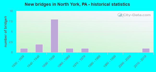
- New bridges - historical statistics
- 11930-1939
- 21940-1949
- 81950-1959
- 11960-1969
- 11970-1979
- 12010-2019

- Reconstructed bridges - Historical Statistics
- 11940-1949
- 01950-1959
- 01960-1969
- 11970-1979
- 01980-1989
- 01990-1999
- 32000-2009
- 22010-2019


- Bridge Condition - Deck
- 10.0%Very good
- 10.0%Good
- 20.0%Satisfactory
- 50.0%Fair
- 10.0%Poor

- Bridge Condition - Superstructure
- 10.0%Excellent
- 10.0%Satisfactory
- 80.0%Fair

- Bridge Condition - Substructure
- 20.0%Good
- 40.0%Satisfactory
- 40.0%Fair

- Bridge Condition - Channel
- 14.3%Good
- 42.9%Satisfactory
- 14.3%Fair
- 28.6%Poor
Find on map >> Show street view
Structure Number: 37367, Location: 0.3 MI E OF I-83 (Lat: 39.983831, Lng: -76.723442), Route carried "on" structure: US 30, Year Built: 1949, Year Reconstructed: 2011, Status: Open, Structure Length: 13.72m (45.01ft), Average Daily Traffic: 22,235 (year 2020), Truck Traffic: 15%, Average Future Daily Traffic: 39,517 (year 2040), Design Load: HS 20, Features Intersected: CODORUS CREEK
Minimum Vertical Clearance: 30+ m (98+ ft), Kilometerpoint: 25.835, Lanes on structure: 3, Base Highway Network: Yes, Owner: State Highway Agency, Approaching Roadway Width: 10.4m (34.1ft), Skew: 21 degrees, Material/Design: Concrete continuous, Design/Construction: Tee Beam, Number Of Spans In Main Unit: 7, Length of Maximum Span: 23.8m (78.1ft), Curb or Sidewalk Widths: Left: 0.3m (1.0ft), Right: 0.2m (0.7ft), Curb-To-Curb Width: 10.1m (33.1ft), Out-to-Out Width: 12.7m (41.7ft)
Condition: Deck: Fair, Superstructure: Fair, Substructure: Fair, Channel: Poor, Operating Rating: 52.6 metric tons, Method Used To Determine Operating Rating: Allowable Stress (AS), Inventory Rating: 26.3 metric tons, Method Used To Determine Inventory Rating: Allowable Stress (AS), Structural Evaluation: Somewhat better than minimum adequacy, Deck Geometry: High priority of replacement, Waterway Adequacy: Superior to present desirable criteria, Approach Roadway Alignment: Equal to present desirable criteria, Length Of Structure Improvement: 14.70m (48.23ft), Designated Inspection Frequency: Every 24 months, Inspection Date: October 2019, Bridge Improvement Cost: $207,000, Roadway Improvement Cost: $610,000, Total Project Cost: $2,796,000, Deck Structure Type: Concrete Cast-file-Place, Wearing Surface/Protective System: Wearing Surface: Monolithic Concrete, Deck Protection: Epoxy Coated Reinforcing
Find on map >> Show street view
Structure Number: 37368, Location: .5 MI.E. OF I-83 (Lat: 39.983803, Lng: -76.720922), Route carried "on" structure: US 30, Year Built: 1948, Year Reconstructed: 2010, Status: Open, Structure Length: 6.10m (20.01ft), Average Daily Traffic: 44,573 (year 2020), Truck Traffic: 15%, Average Future Daily Traffic: 68,705 (year 2032), Design Load: HS 20, Features Intersected: Norfolk Southern RR
Minimum Vertical Clearance: 30+ m (98+ ft), Kilometerpoint: 25.835, Lanes on structure: 4, Base Highway Network: Yes, Owner: State Highway Agency, Approaching Roadway Width: 25.6m (84.0ft), Skew: 20 degrees, Material/Design: Concrete, Design/Construction: Tee Beam, Number Of Spans In Main Unit: 5, Length of Maximum Span: 13.1m (43.0ft), Curb or Sidewalk Widths: Left: 1.5m (4.9ft), Right: 1.2m (3.9ft), Curb-To-Curb Width: 25.6m (84.0ft), Out-to-Out Width: 29.7m (97.4ft)
Condition: Deck: Satisfactory, Superstructure: Fair, Substructure: Satisfactory, Operating Rating: 46.3 metric tons, Method Used To Determine Operating Rating: Load Factor (LF), Inventory Rating: 28.1 metric tons, Method Used To Determine Inventory Rating: Load Factor (LF), Structural Evaluation: Somewhat better than minimum adequacy, Deck Geometry: Superior to present desirable criteria, Underclear: High priority of corrective action, Approach Roadway Alignment: Equal to present desirable criteria, Length Of Structure Improvement: 7.10m (23.29ft), Designated Inspection Frequency: Every 24 months, Inspection Date: September 2021, Bridge Improvement Cost: $160,000, Roadway Improvement Cost: $470,000, Total Project Cost: $2,157,000, Deck Structure Type: Concrete Cast-file-Place, Wearing Surface/Protective System: Wearing Surface: Integral Concrete
Find on map >> Show street view
Structure Number: 37442, Location: 0.8 MI S OF EXIT-19, I-83 (Lat: 39.979222, Lng: -76.722722), Route carried "on" structure: Interstate 83, Year Built: 1959, Status: Open, Structure Length: 2.23m (7.32ft), Average Daily Traffic: 70,986 (year 2020), Truck Traffic: 10%, Average Future Daily Traffic: 70,386 (year 2032), Design Load: HS 20, Features Intersected: MILL CREEK
Minimum Vertical Clearance: 30+ m (98+ ft), Kilometerpoint: 32.105, Lanes on structure: 4, Base Highway Network: Yes, Owner: State Highway Agency, Approaching Roadway Width: 25.6m (84.0ft), Skew: 33 degrees, Material/Design: Concrete, Design/Construction: Tee Beam, Number Of Spans In Main Unit: 2, Length of Maximum Span: 10.7m (35.1ft), Curb-To-Curb Width: 21.9m (71.9ft), Out-to-Out Width: 31.1m (102.0ft)
Condition: Deck: Fair, Superstructure: Fair, Substructure: Fair, Channel: Satisfactory, Operating Rating: 81.6 metric tons, Method Used To Determine Operating Rating: Load Factor (LF), Inventory Rating: 49.0 metric tons, Method Used To Determine Inventory Rating: Load Factor (LF), Structural Evaluation: Somewhat better than minimum adequacy, Deck Geometry: Better than present minimum criteria, Waterway Adequacy: Superior to present desirable criteria, Approach Roadway Alignment: Equal to present desirable criteria, Length Of Structure Improvement: 2.90m (9.51ft), Designated Inspection Frequency: Every 24 months, Inspection Date: October 2019, Bridge Improvement Cost: $39,000, Roadway Improvement Cost: $116,000, Total Project Cost: $531,000
Find on map >> Show street view
Structure Number: 37443, Location: 0.6 MI.S. US Rt 30 INTER (Lat: 39.979125, Lng: -76.721486), Route carried "on" structure: Interstate 83, Year Built: 1959, Status: Open, Structure Length: 15.15m (49.70ft), Average Daily Traffic: 70,986 (year 2020), Truck Traffic: 10%, Average Future Daily Traffic: 70,386 (year 2032), Design Load: HS 20, Features Intersected: Norfolk Southern RR
Minimum Vertical Clearance: 30+ m (98+ ft), Kilometerpoint: 32.863, Lanes on structure: 4, Base Highway Network: Yes, Owner: State Highway Agency, Approaching Roadway Width: 21.9m (71.9ft), Skew: 30 degrees, Material/Design: Steel continuous, Design/Construction: Stringer/Multi-beam, Number Of Spans In Main Unit: 5, Length of Maximum Span: 36.6m (120.1ft), Curb or Sidewalk Widths: Left: 0.2m (0.7ft), Right: 0.2m (0.7ft), Curb-To-Curb Width: 17.4m (57.1ft), Out-to-Out Width: 19.4m (63.6ft)
Condition: Deck: Fair, Superstructure: Fair, Substructure: Fair, Operating Rating: 82.6 metric tons, Method Used To Determine Operating Rating: Load Factor (LF), Inventory Rating: 49.0 metric tons, Method Used To Determine Inventory Rating: Load Factor (LF), Structural Evaluation: Somewhat better than minimum adequacy, Deck Geometry: Meets minimum limits, Underclear: High priority of corrective action, Approach Roadway Alignment: Equal to present desirable criteria, Length Of Structure Improvement: 16.10m (52.82ft), Designated Inspection Frequency: Every 24 months, Inspection Date: September 2021, Bridge Improvement Cost: $73,000, Roadway Improvement Cost: $216,000, Total Project Cost: $989,000, Deck Structure Type: Concrete Cast-file-Place, Wearing Surface/Protective System: Wearing Surface: Latex Concrete
Find on map >> Show street view
Structure Number: 37444, Location: 0.5 MI S OF EXIT-9, I-83 (Lat: 39.979247, Lng: -76.722869), Route carried "on" structure: Interstate 83, Year Built: 1959, Status: Open, Structure Length: 4.45m (14.60ft), Average Daily Traffic: 70,986 (year 2020), Truck Traffic: 10%, Average Future Daily Traffic: 70,386 (year 2032), Design Load: HS 20, Features Intersected: SR 3029; LOUCKS MILL RD
Minimum Vertical Clearance: 30+ m (98+ ft), Kilometerpoint: 32.863, Lanes on structure: 4, Lanes under structure: 2, Base Highway Network: Yes, Owner: State Highway Agency, Approaching Roadway Width: 21.9m (71.9ft), Skew: 30 degrees, Material/Design: Prestressed concrete, Design/Construction: Stringer/Multi-beam, Number Of Spans In Main Unit: 3, Length of Maximum Span: 16.2m (53.1ft), Curb or Sidewalk Widths: Left: 0.2m (0.7ft), Right: 0.2m (0.7ft), Curb-To-Curb Width: 21.0m (68.9ft), Out-to-Out Width: 21.8m (71.5ft)
Condition: Deck: Fair, Superstructure: Fair, Substructure: Fair, Operating Rating: 91.6 metric tons, Method Used To Determine Operating Rating: Load Factor (LF), Inventory Rating: 36.3 metric tons, Method Used To Determine Inventory Rating: Load Factor (LF), Structural Evaluation: Somewhat better than minimum adequacy, Deck Geometry: Better than present minimum criteria, Underclear: Superior to present desirable criteria, Approach Roadway Alignment: Equal to present desirable criteria, Length Of Structure Improvement: 5.40m (17.72ft), Designated Inspection Frequency: Every 24 months, Inspection Date: October 2019, Deck Structure Type: Concrete Cast-file-Place, Wearing Surface/Protective System: Wearing Surface: Latex Concrete
Find on map >> Show street view
Structure Number: 37445, Location: 0.4 MI S of Exit-21,I-83 (Lat: 39.979792, Lng: -76.725356), Route carried "on" structure: Interstate 83, Year Built: 1959, Year Reconstructed: 1984, Status: Open, Structure Length: 16.06m (52.69ft), Average Daily Traffic: 70,986 (year 2020), Truck Traffic: 10%, Average Future Daily Traffic: 70,386 (year 2032), Design Load: HS 20, Features Intersected: YorkRail & Codorus Creek
Minimum Vertical Clearance: 30+ m (98+ ft), Kilometerpoint: 32.863, Lanes on structure: 4, Base Highway Network: Yes, Owner: State Highway Agency, Approaching Roadway Width: 21.9m (71.9ft), Skew: 39 degrees, Material/Design: Prestressed concrete, Design/Construction: Stringer/Multi-beam, Number Of Spans In Main Unit: 7, Number Of Approach Spans: 1, Length of Maximum Span: 25.3m (83.0ft), Curb or Sidewalk Widths: Left: 0.2m (0.7ft), Right: 0.2m (0.7ft), Curb-To-Curb Width: 17.7m (58.1ft), Out-to-Out Width: 19.4m (63.6ft)
Condition: Deck: Fair, Superstructure: Fair, Substructure: Satisfactory, Channel: Satisfactory, Operating Rating: 88.0 metric tons, Method Used To Determine Operating Rating: Load Factor (LF), Inventory Rating: 21.8 metric tons, Method Used To Determine Inventory Rating: Load Factor (LF), Structural Evaluation: Somewhat better than minimum adequacy, Deck Geometry: Meets minimum limits, Underclear: High priority of replacement, Waterway Adequacy: Superior to present desirable criteria, Approach Roadway Alignment: Equal to present desirable criteria, Length Of Structure Improvement: 16.90m (55.45ft), Designated Inspection Frequency: Every 24 months, Inspection Date: September 2021, Bridge Improvement Cost: $759,000, Roadway Improvement Cost: $2,234,000, Total Project Cost: $10,241,000, Deck Structure Type: Concrete Cast-file-Place, Wearing Surface/Protective System: Wearing Surface: Latex Concrete
Find on map >> Show street view
Structure Number: 37448, Location: I83 & US RT 30 INTERCHNG. (Lat: 39.983981, Lng: -76.730097), Route carried "on" structure: Interstate 83, Year Built: 1959, Year Reconstructed: 2013, Status: Open, Structure Length: 6.52m (21.39ft), Average Daily Traffic: 51,776 (year 2020), Truck Traffic: 15%, Average Future Daily Traffic: 65,922 (year 2032), Design Load: HS 20, Features Intersected: US 30; SR 0030
Minimum Vertical Clearance: 30+ m (98+ ft), Kilometerpoint: 33.713, Lanes on structure: 5, Lanes under structure: 10, Base Highway Network: Yes, Owner: State Highway Agency, Approaching Roadway Width: 23.8m (78.1ft), Skew: 33 degrees, Material/Design: Steel continuous, Design/Construction: Stringer/Multi-beam, Number Of Spans In Main Unit: 3, Length of Maximum Span: 33.8m (110.9ft), Curb or Sidewalk Widths: Left: 0.2m (0.7ft), Right: 0.2m (0.7ft), Curb-To-Curb Width: 22.9m (75.1ft), Out-to-Out Width: 24.2m (79.4ft)
Condition: Deck: Poor, Superstructure: Fair, Substructure: Satisfactory, Operating Rating: 43.5 metric tons, Method Used To Determine Operating Rating: Load Factor (LF), Inventory Rating: 26.3 metric tons, Method Used To Determine Inventory Rating: Load Factor (LF), Structural Evaluation: Somewhat better than minimum adequacy, Deck Geometry: Somewhat better than minimum adequacy, Underclear: Equal to present minimum criteria, Approach Roadway Alignment: Equal to present desirable criteria, Length Of Structure Improvement: 6.50m (21.33ft), Designated Inspection Frequency: Every 24 months, Inspection Date: November 2019, Bridge Improvement Cost: $171,000, Roadway Improvement Cost: $505,000, Total Project Cost: $2,313,000, Deck Structure Type: Concrete Cast-file-Place, Wearing Surface/Protective System: Wearing Surface: Latex Concrete
Find on map >> Show street view
Structure Number: 37852, Location: NORTH YORK LOUCKS MILL RD (Lat: 39.982678, Lng: -76.722439), Route carried "on" structure: State highway , Year Built: 1938, Year Reconstructed: 1949, Status: Open, Structure Length: 1.34m (4.40ft), Average Daily Traffic: 5,799 (year 2020), Truck Traffic: 19%, Average Future Daily Traffic: 5,323 (year 2032), Design Load: HS 20, Features Intersected: MILL CREEK, Facility Carried by Structure: SR 3029
Minimum Vertical Clearance: 30+ m (98+ ft), Kilometerpoint: 1.975, Lanes on structure: 2, Owner: State Highway Agency, Approaching Roadway Width: 6.4m (21.0ft), Material/Design: Concrete, Design/Construction: Tee Beam, Number Of Spans In Main Unit: 1, Length of Maximum Span: 12.2m (40.0ft), Curb or Sidewalk Widths: Left: 0.8m (2.6ft), Right: 0.8m (2.6ft), Curb-To-Curb Width: 7.1m (23.3ft), Out-to-Out Width: 8.6m (28.2ft)
Condition: Deck: Satisfactory, Superstructure: Fair, Substructure: Good, Channel: Satisfactory, Operating Rating: 59.0 metric tons, Method Used To Determine Operating Rating: Load Factor (LF), Inventory Rating: 35.4 metric tons, Method Used To Determine Inventory Rating: Load Factor (LF), Structural Evaluation: Somewhat better than minimum adequacy, Deck Geometry: High priority of replacement, Waterway Adequacy: Equal to present minimum criteria, Approach Roadway Alignment: Equal to present desirable criteria, Length Of Structure Improvement: 2.00m (6.56ft), Designated Inspection Frequency: Every 24 months, Inspection Date: October 2019, Bridge Improvement Cost: $47,000, Roadway Improvement Cost: $139,000, Total Project Cost: $637,000, Deck Structure Type: Concrete Cast-file-Place, Wearing Surface/Protective System: Wearing Surface: Bituminous
Find on map >> Show street view
Structure Number: 38169, Location: .2E I-83/TRIB. CODORUS CR (Lat: 39.987586, Lng: -76.728069), Route carried "on" structure: City street , Year Built: 1975, Year Reconstructed: 2018, Status: Open, Structure Length: 1.19m (3.90ft), Average Daily Traffic: 3,000 (year 1999), Truck Traffic: 25%, Average Future Daily Traffic: 2,100 (year 2011), Design Load: HS 20, Features Intersected: TRIBUTARY CODORUS CREEK, Facility Carried by Structure: TORONITA ST
Minimum Vertical Clearance: 30+ m (98+ ft), Kilometerpoint: 0.000, Lanes on structure: 2, Owner: Town or Township Highway Agency, Approaching Roadway Width: 10.4m (34.1ft), Skew: 1 degrees, Material/Design: Prestressed concrete, Design/Construction: Box Beam or Girders - Single/Spread, Number Of Spans In Main Unit: 1, Length of Maximum Span: 11.3m (37.1ft), Curb-To-Curb Width: 10.4m (34.1ft), Out-to-Out Width: 11.4m (37.4ft)
Condition: Deck: Very good, Superstructure: Excellent, Substructure: Good, Channel: Fair, Operating Rating: 71.7 metric tons, Method Used To Determine Operating Rating: Load and Resistance Factor (LRFR), Inventory Rating: 51.7 metric tons, Method Used To Determine Inventory Rating: Load and Resistance Factor (LRFR), Structural Evaluation: Better than present minimum criteria, Deck Geometry: Somewhat better than minimum adequacy, Waterway Adequacy: Superior to present desirable criteria, Approach Roadway Alignment: Equal to present desirable criteria, Length Of Structure Improvement: 1.80m (5.91ft), Designated Inspection Frequency: Every 24 months, Inspection Date: October 2020, Bridge Improvement Cost: $5,000, Roadway Improvement Cost: $14,000, Total Project Cost: $65,000, Deck Structure Type: Concrete Cast-file-Place, Wearing Surface/Protective System: Wearing Surface: Monolithic Concrete, Deck Protection: Epoxy Coated Reinforcing
Find on map >> Show street view
Structure Number: 40665, Location: 0.3 MI E OF I-83 (Lat: 39.983947, Lng: -76.723225), Route carried "on" structure: US 30, Year Built: 1969, Year Reconstructed: 2011, Status: Open, Structure Length: 13.69m (44.91ft), Average Daily Traffic: 20,815 (year 2020), Truck Traffic: 14%, Average Future Daily Traffic: 44,113 (year 2032), Design Load: HS 20, Features Intersected: CODORUS CREEK
Minimum Vertical Clearance: 30+ m (98+ ft), Kilometerpoint: 25.922, Lanes on structure: 2, Base Highway Network: Yes, Owner: State Highway Agency, Approaching Roadway Width: 10.4m (34.1ft), Skew: 21 degrees, Material/Design: Prestressed concrete, Design/Construction: Stringer/Multi-beam, Number Of Spans In Main Unit: 7, Length of Maximum Span: 23.8m (78.1ft), Curb or Sidewalk Widths: Left: 1.5m (4.9ft), Right: 1.5m (4.9ft), Curb-To-Curb Width: 10.4m (34.1ft), Out-to-Out Width: 17.0m (55.8ft)
Condition: Deck: Good, Superstructure: Satisfactory, Substructure: Satisfactory, Channel: Poor, Operating Rating: 54.4 metric tons, Method Used To Determine Operating Rating: Load Factor (LF), Inventory Rating: 20.0 metric tons, Method Used To Determine Inventory Rating: Load Factor (LF), Structural Evaluation: Somewhat better than minimum adequacy, Deck Geometry: Somewhat better than minimum adequacy, Waterway Adequacy: Superior to present desirable criteria, Approach Roadway Alignment: Equal to present desirable criteria, Length Of Structure Improvement: 14.70m (48.23ft), Designated Inspection Frequency: Every 24 months, Inspection Date: October 2019, Bridge Improvement Cost: $785,000, Roadway Improvement Cost: $2,311,000, Total Project Cost: $10,593,000, Deck Structure Type: Concrete Cast-file-Place, Wearing Surface/Protective System: Wearing Surface: Monolithic Concrete, Deck Protection: Epoxy Coated Reinforcing
Find on map >> Show street view
Structure Number: 56715, Location: 0.2 MI NW of Sand Bank Rd (Lat: 39.990750, Lng: -76.717806), Route carried "on" structure: City street , Year Built: 2019, Status: Open, Structure Length: 0.82m (2.69ft), Average Daily Traffic: 100 (year 2019), Truck Traffic: 25%, Average Future Daily Traffic: 125 (year 2039), Features Intersected: Trib. to Codorus Creek, Facility Carried by Structure: T-837 Eden Rd
Minimum Vertical Clearance: 30+ m (98+ ft), Kilometerpoint: 0.000, Lanes on structure: 2, Owner: Town or Township Highway Agency, Approaching Roadway Width: 14.0m (45.9ft), Skew: 4 degrees, Material/Design: Concrete, Design/Construction: Culvert, Number Of Spans In Main Unit: 3, Length of Maximum Span: 0.9m (3.0ft), Curb or Sidewalk Widths: Left: 0.5m (1.6ft), Right: 4.1m (13.5ft), Curb-To-Curb Width: 11.2m (36.7ft), Out-to-Out Width: 16.8m (55.1ft)
Condition: Channel: Good, Culverts: Satisfactory, Operating Rating: 54.4 metric tons, Method Used To Determine Operating Rating: Field evaluation and documented engineering judgment, Inventory Rating: 32.7 metric tons, Method Used To Determine Inventory Rating: Field evaluation and documented engineering judgment, Structural Evaluation: Equal to present minimum criteria, Deck Geometry: Superior to present desirable criteria, Waterway Adequacy: Better than present minimum criteria, Approach Roadway Alignment: Equal to present desirable criteria, Designated Inspection Frequency: Every 24 months, Inspection Date: April 2021
Find on map >> Show street view
Structure Number: 37444, Location: 0.5 MI S OF EXIT-9, I-83 (Lat: 39.979247, Lng: -76.722869), Route carried "under" structure: State highway , Year Built: 1959, Structure Length: 0. m, Average Daily Traffic: 5,799 (year 2020), Truck Traffic: 19%, Features Intersected: SR 3029; LOUCKS MILL RD, Facility Carried by Structure: I-83; SR 0083
Minimum Vertical Clearance: 8.81m (28.90ft), Kilometerpoint: 1.242, Lanes on structure: 4, Lanes under structure: 2, Material/Design: Prestressed concrete, Design/Construction: Stringer/Multi-beam, Length of Maximum Span: 16.2m (53.1ft)
Find on map >> Show street view
Structure Number: 37448, Location: I83 & US RT 30 INTERCHNG. (Lat: 39.983981, Lng: -76.730097), Route carried "under" structure: Alternate US 30, Year Built: 1959, Structure Length: 0. m, Average Daily Traffic: 22,235 (year 2020), Truck Traffic: 15%, Features Intersected: US 30; SR 0030, Facility Carried by Structure: I-83; SR 0083
Minimum Vertical Clearance: 4.45m (14.60ft), Kilometerpoint: 25.286, Lanes on structure: 5, Lanes under structure: 5, Material/Design: Steel continuous, Design/Construction: Stringer/Multi-beam, Length of Maximum Span: 33.8m (110.9ft)
Find on map >> Show street view
Structure Number: 37448, Location: I83 & US RT 30 INTERCHNG. (Lat: 39.983981, Lng: -76.730097), Route carried "under" structure: Alternate US 30, Year Built: 1959, Structure Length: 0. m, Average Daily Traffic: 20,815 (year 2020), Truck Traffic: 14%, Features Intersected: US 30; SR 0030, Facility Carried by Structure: I-83; SR 0083
Minimum Vertical Clearance: 4.66m (15.29ft), Kilometerpoint: 25.333, Lanes on structure: 5, Lanes under structure: 5, Material/Design: Steel continuous, Design/Construction: Stringer/Multi-beam, Length of Maximum Span: 33.8m (110.9ft)